Middleton Junction

Settlement in Lancashire

England

Middleton Junction

Sewage Works Part of the old sewage works.
Sewage Works Credit: Peter McDermott

Middleton Junction is a small village located in the county of Lancashire, England. Situated approximately 6 miles north of Manchester city center, it falls within the Metropolitan Borough of Rochdale. With a population of around 2,000 residents, Middleton Junction is a close-knit community that offers a peaceful and friendly atmosphere.

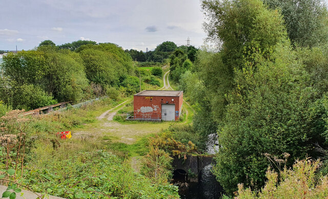
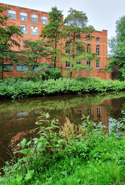
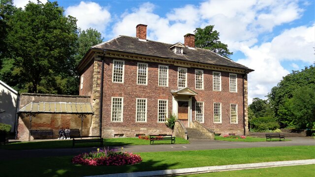
The village has a rich history, dating back to the industrial revolution when it served as a hub for textile production. Many of the original mills and buildings still stand, serving as a reminder of the area's industrial past. Today, Middleton Junction is known for its charming architecture and picturesque landscapes, making it an attractive destination for nature lovers.

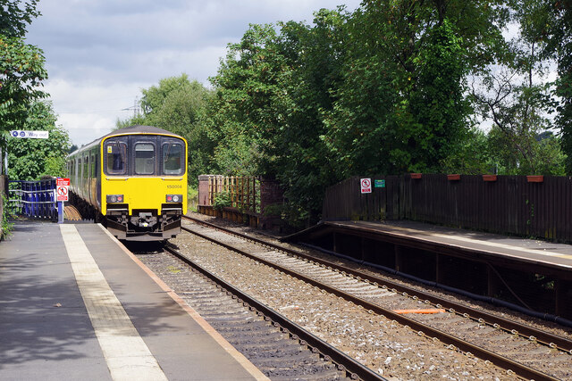
The village offers a range of amenities to its residents and visitors. There are several local shops, pubs, and restaurants, providing a variety of goods and services. Middleton Junction also benefits from excellent transport links, with regular bus services connecting it to nearby towns and cities. The village is conveniently located near major motorway networks, including the M60 and M62, allowing for easy access to the wider region.

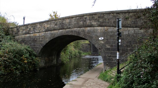
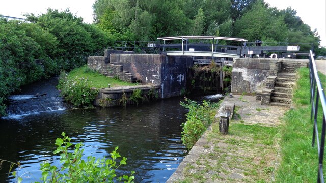
Nature enthusiasts can explore the nearby countryside, with scenic walks along the Rochdale Canal and surrounding green spaces. Middleton Junction is also home to several parks and recreational areas, offering opportunities for outdoor activities and relaxation.

Overall, Middleton Junction is a charming village that combines its industrial heritage with modern amenities and natural beauty. It provides a peaceful and welcoming environment for residents and visitors alike.

If you have any feedback on the listing, please let us know in the comments section below.

Middleton Junction Images

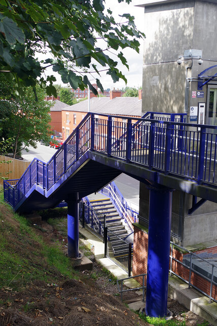
Images are sourced within 2km of 53.53855/-2.16972 or Grid Reference SD8804. Thanks to Geograph Open Source API. All images are credited.

Sewage Works Part of the old sewage works.
Sewage Works
Part of the old sewage works.
Malta Mill Old cotton mill alongside the Rochdale Canal.
Malta Mill
Old cotton mill alongside the Rochdale Canal.
Disused Canal Branch Branch off the Rochdale Canal leading to Ferney Field Colliery.
Disused Canal Branch
Branch off the Rochdale Canal leading to Ferney Field Colliery.
Locks on the Rochdale Canal Limefield farmhouse seen on the left of view
Locks on the Rochdale Canal
Limefield farmhouse seen on the left of view
Middleton Road View from railway bridge at Mills Hill Station
Middleton Road
View from railway bridge at Mills Hill Station
Scowcroft Lane Bridge Over the Rochdale Canal and carrying the No.70
Scowcroft Lane Bridge
Over the Rochdale Canal and carrying the No.70
Foxdenton Hall The south facade
Foxdenton Hall
The south facade
River Irk View from the towpath on the Rochdale Canal Aqueduct
River Irk
View from the towpath on the Rochdale Canal Aqueduct
Rochdale Canal Lock No.64 Kay Lane lock
Rochdale Canal Lock No.64
Kay Lane lock
Old Railway Trackbed Now a cycleway and path off Ferney Field Road
Old Railway Trackbed
Now a cycleway and path off Ferney Field Road
Major Earth Remediation Works View from the old railway trackbed to Middleton Junction
Major Earth Remediation Works
View from the old railway trackbed to Middleton Junction
Mills Hill Station A class 150 unit operated by Northern departs Mills Hill near the end of its Clitheroe to Rochdale journey. Although a station did briefly exist on this site in the 19th century, the modern facility dates only from 1985.
Mills Hill Station
A class 150 unit operated by Northern departs Mills Hill near the end of its Clitheroe to Rochdale journey. Although a station did briefly exist on this site in the 19th century, the modern facility dates only from 1985.
Steps at Mills Hill Station Mills Hill station is relatively new having opened in 1985. To site it adjacent to Oldham Road it was necessary to install a set of 27 steps on this side of the railway. Fortunately a lift is also provided.
Steps at Mills Hill Station
Mills Hill station is relatively new having opened in 1985. To site it adjacent to Oldham Road it was necessary to install a set of 27 steps on this side of the railway. Fortunately a lift is also provided.
Under Mills Hill Railway Bridge The railway bridge carries the Manchester to Rochdale railway across the A669. It was built in 1934, replacing an earlier bridge, allowing double deck trams and buses to pass underneath. Mills Hill station is located immediately to the south of the bridge. The boundary between the boroughs of Oldham and Rochdale is located here - the community of Mills Hill straddling both sides.
Under Mills Hill Railway Bridge
The railway bridge carries the Manchester to Rochdale railway across the A669. It was built in 1934, replacing an earlier bridge, allowing double deck trams and buses to pass underneath. Mills Hill station is located immediately to the south of the bridge. The boundary between the boroughs of Oldham and Rochdale is located here - the community of Mills Hill straddling both sides.
Mills Hill Bridge Mills Hill Bridge carries the Manchester to Rochdale railway over the A669 between Chadderton and Middleton. Mills Hill station is to the left accessed by a long flight of steps. The large billboard advertises 'See how they run' a whodunnit comedy spoof 'in cinemas September 9'.
Mills Hill Bridge
Mills Hill Bridge carries the Manchester to Rochdale railway over the A669 between Chadderton and Middleton. Mills Hill station is to the left accessed by a long flight of steps. The large billboard advertises 'See how they run' a whodunnit comedy spoof 'in cinemas September 9'.
Rochdale Canal, Mills Hill A pipe bridge crosses the canal to the south of Oldham Road bridge in the Mills Hill area. Just ahead on the right is Malta Mill, a former cotton mill built in 1904.
Rochdale Canal, Mills Hill
A pipe bridge crosses the canal to the south of Oldham Road bridge in the Mills Hill area. Just ahead on the right is Malta Mill, a former cotton mill built in 1904.
Work on the Rochdale Canal, Mills Hill Bank repairs are taking place here just north of Oldham Road bridge, although there was no sign of activity on this Thursday lunchtime. Both the towpath and the navigation are open although boat traffic would be limited by the closure of the canal north of Rochdale due to water shortages.
Work on the Rochdale Canal, Mills Hill
Bank repairs are taking place here just north of Oldham Road bridge, although there was no sign of activity on this Thursday lunchtime. Both the towpath and the navigation are open although boat traffic would be limited by the closure of the canal north of Rochdale due to water shortages.
Angling success on the Rochdale Canal Why this is here by the towpath close to the River Irk aqueduct is unclear - presumably the Canal and River Trust has sanctioned it but it is certainly not a common thing to find on the canal network. Which is just as well because if every canal angler put up something similar there would be no room for the towpath. Still, at least it tells us that these fish are present in the water.
Angling success on the Rochdale Canal
Why this is here by the towpath close to the River Irk aqueduct is unclear - presumably the Canal and River Trust has sanctioned it but it is certainly not a common thing to find on the canal network. Which is just as well because if every canal angler put up something similar there would be no room for the towpath. Still, at least it tells us that these fish are present in the water.
Show me another place!

Middleton Junction is located at Grid Ref: SD8804 (Lat: 53.53855, Lng: -2.16972)

Unitary Authority: Oldham

Police Authority: Greater Manchester

What 3 Words

///office.remedy.senior. Near Middleton, Manchester

Nearby Locations

Middleton Junction

Related Wikis

Middleton Junction

Middleton Junction is an industrial and residential district lying on the common border of Middleton in the Metropolitan Borough of Rochdale and Chadderton...

Middleton Junction railway station

Middleton Junction railway station was an early junction station on the Manchester and Leeds Railway, it opened when the branch to Oldham opened in 1842...

Junction Mill, Middleton Junction

Junction Mill, Middleton Junction is a cotton spinning mill at Middleton junction, Chadderton in Greater Manchester alongside the Rochdale Canal. It was...

Foxdenton

Foxdenton is a semi rural locality in Chadderton in the Metropolitan Borough of Oldham, Greater Manchester. It is located in the west of Chadderton....

Nearby Amenities

Located within 500m of 53.53855,-2.16972
Middleton Junction
Is In: Oldham, Greater Manchester, England, UK
Name Ur: مڈلٹن جنکشن
Place: suburb
Source: npe
Lat/Long: 53.5407739/-2.1675095
Waterway: turning_point
Lat/Long: 53.5342446/-2.1678224
Seamark Type: gate
Waterway: lock_gate
Lat/Long: 53.542288/-2.1692145
Middleton Junction
Historic Railway: junction
Railway: site
Lat/Long: 53.5418399/-2.171133
Bus Stop
Broadgate
Bus: yes
Naptan AtcoCode: 1800ED03531
Naptan Bearing: S
Naptan CommonName: Broadgate
Naptan Indicator: Opp Warehouse
Naptan Landmark: BUSINESS Park
Naptan NaptanCode: manajwtw
Naptan PlusbusZoneRef: MNCRPIC
Naptan ShortCommonName: Broadgate
Naptan Street: BROADGATE
Naptan Verified: no
Network: TfGM
Public Transport: platform
Source: naptan_import
Lat/Long: 53.5355068/-2.1690176
Bus Stop
Middleton Junction, Foxdenton Lane / opposite Broadgate
Bus: yes
Naptan AtcoCode: 1800ED05791
Naptan Bearing: W
Naptan CommonName: Grimshaw Lane/Broadgate
Naptan Indicator: Adj To Car Park
Naptan Landmark: EATON
Naptan NaptanCode: mantgjat
Naptan PlusbusZoneRef: MNCRPIC
Naptan ShortCommonName: Broadgate
Naptan Street: FOXDENTON LANE
Naptan Verified: no
Network: TfGM
Operator: Foxdenton Lane
Public Transport: platform
Source: naptan_import
Lat/Long: 53.5401892/-2.1694587
Bus Stop
Middleton Junction, Greengate / Middleton Junction (Stop D)
Bus: yes
Local Ref: D
Naptan AtcoCode: 1800ED10411
Naptan Bearing: SW
Naptan CommonName: Greengate/Middleton Junction (Stop D)
Naptan Indicator: Stop D
Naptan Landmark: OP EXPRESS SERV
Naptan NaptanCode: manamjgw
Naptan PlusbusZoneRef: MNCRPIC
Naptan ShortCommonName: Middleton Jct
Naptan Street: GREENGATE
Naptan Verified: no
Network: TfGM
Operator: TfGM
Public Transport: platform
Ref: D
Source: naptan_import
Lat/Long: 53.5409294/-2.1735813
Bus Stop
Joshua Lane/Greenhill Road
Bus: yes
Naptan AtcoCode: 1800ED19661
Naptan Bearing: S
Naptan CommonName: Joshua Lane/Greenhill Road
Naptan Indicator: Gas Depot
Naptan Landmark: NURSERY
Naptan NaptanCode: manataga
Naptan PlusbusZoneRef: MNCRPIC
Naptan ShortCommonName: Greenhill Road
Naptan Street: JOSHUA LANE
Naptan Verified: no
Network: TfGM
Public Transport: platform
Source: naptan_import
Lat/Long: 53.5427202/-2.1721399
Bus Stop
Middleton Junction (Stop B)
Bench: no
Bus: yes
Local Ref: B
Naptan AtcoCode: 1800ED19681
Naptan Bearing: S
Naptan CommonName: Middleton Junction (Stop B)
Naptan Indicator: Stop B
Naptan Landmark: OPP BREWERY
Naptan NaptanCode: manatagd
Naptan PlusbusZoneRef: MNCRPIC
Naptan ShortCommonName: Middleton Jct
Naptan Street: LEES STREET
Naptan Verified: no
Network: TfGM
Public Transport: platform
Shelter: no
Source: naptan_import
Lat/Long: 53.5417576/-2.1726793
Bus Stop
Middleton Junction, Grimshaw Lane / Moston Road (Stop F)
Bus: yes
Local Ref: F
Naptan AtcoCode: 1800ED19691
Naptan Bearing: NW
Naptan CommonName: Grimshaw Lane/Moston Road (Stop F)
Naptan Indicator: Stop F
Naptan Landmark: RADCLYFFE ARM
Naptan NaptanCode: manatagj
Naptan PlusbusZoneRef: MNCRPIC
Naptan ShortCommonName: Moston Road
Naptan Street: GRIMSHAW LANE
Naptan Verified: no
Network: TfGM
Operator: TfGM
Public Transport: platform
Ref: F
Source: naptan_import
Lat/Long: 53.5406444/-2.1717693
Bus Stop
Middleton Junction, Grimshaw Lane / Moston Road (Stop E)
Bus: yes
Local Ref: E
Naptan AtcoCode: 1800ED19701
Naptan Bearing: SE
Naptan CommonName: Grimshaw Lane/Moston Road (Stop E)
Naptan Indicator: Stop E
Naptan Landmark: OPP PUBLIC HSE
Naptan NaptanCode: manatagm
Naptan PlusbusZoneRef: MNCRPIC
Naptan ShortCommonName: Moston Road
Naptan Street: GRIMSHAW LANE
Naptan Verified: no
Network: TfGM
Operator: TfGM
Public Transport: platform
Ref: E
Source: naptan_import
Lat/Long: 53.540851/-2.1718758
Bus Stop
Middleton Junction, Foxdenton Lane / near Springs Road
Bus: yes
Naptan AtcoCode: 1800ED19711
Naptan Bearing: W
Naptan CommonName: Foxdenton Lane/Springs Road
Naptan Indicator: O/s Caterers
Naptan Landmark: CATERERS
Naptan NaptanCode: manatagp
Naptan Notes: STOP MOVEMENT
Naptan PlusbusZoneRef: MNCRPIC
Naptan ShortCommonName: Springs Road
Naptan Street: FOXDENTON LANE
Naptan Verified: no
Network: TfGM
Operator: TfGM
Public Transport: platform
Source: naptan_import
Lat/Long: 53.5399052/-2.1668773
Bus Stop
Middleton Junction, Foxdenton Lane / opposite Springs Road
Bus: yes
Naptan AtcoCode: 1800ED19721
Naptan Bearing: E
Naptan CommonName: Foxdenton Lane/Springs Road
Naptan Indicator: Nr Grass Land
Naptan Landmark: NR GRASS LAND
Naptan NaptanCode: manatagt
Naptan PlusbusZoneRef: MNCRPIC
Naptan ShortCommonName: Springs Road
Naptan Street: FOXDENTON LANE
Naptan Verified: no
Network: TfGM
Operator: TfGM
Public Transport: platform
Source: naptan_import
Lat/Long: 53.5400879/-2.1648258
Bus Stop
Greengate, Greengate / opposite Stagecoach Depot
Bus: yes
Naptan AtcoCode: 1800ED20201
Naptan Bearing: N
Naptan CommonName: Greengate/Bluebird Depot
Naptan Indicator: Op Bluebird Dep
Naptan Landmark: STAGECOACH
Naptan NaptanCode: mantgdap
Naptan PlusbusZoneRef: MNCRPIC
Naptan ShortCommonName: Bluebird Depot
Naptan Street: GREENGATE
Naptan Verified: no
Network: TfGM
Operator: TfGM
Public Transport: platform
Source: naptan_import
Lat/Long: 53.5362467/-2.17534
Bus Stop
Greengate, Greengate / opposite Mainway East
Bus: yes
Naptan AtcoCode: 1800ED00691
Naptan Bearing: S
Naptan CommonName: Greengate/Mainway East
Naptan Indicator: Sub Station
Naptan Landmark: SUB STATION
Naptan NaptanCode: manajpta
Naptan PlusbusZoneRef: MNCRPIC
Naptan ShortCommonName: Mainway East
Naptan Street: GREENGATE
Naptan Verified: no
Network: TfGM
Operator: TfGM
Public Transport: platform
Source: naptan_import
Lat/Long: 53.5386169/-2.1752166
Bus Stop
Greengate, Greengate / outside Stagecoach Depot
Bus: yes
Naptan AtcoCode: 1800ED00701
Naptan Bearing: S
Naptan CommonName: Greengate/Bluebird Depot
Naptan Indicator: Nr Bluebird Bus
Naptan Landmark: STAGECOACH
Naptan NaptanCode: manajptd
Naptan PlusbusZoneRef: MNCRPIC
Naptan ShortCommonName: Bluebird Depot
Naptan Street: GREENGATE
Naptan Verified: no
Network: TfGM
Operator: TfGM
Public Transport: platform
Source: naptan_import
Lat/Long: 53.5360085/-2.1750262
Bus Stop
Middleton Junction, Greengate / Middleton Junction (Stop C)
Bus: yes
Local Ref: C
Naptan AtcoCode: 1800ED01411
Naptan Bearing: NE
Naptan CommonName: Greengate/Middleton Junction (Stop C)
Naptan Indicator: Stop C
Naptan Landmark: ALLOTMENTS
Naptan NaptanCode: manajtjp
Naptan PlusbusZoneRef: MNCRPIC
Naptan ShortCommonName: Middleton Jct
Naptan Street: GREENGATE
Naptan Verified: no
Network: TfGM
Operator: TfGM
Public Transport: platform
Ref: C
Source: naptan_import
Lat/Long: 53.5410911/-2.1736574
Bus Stop
Greengate, Greengate / near Mainway East
Bus: yes
Naptan AtcoCode: 1800NE00691
Naptan Bearing: N
Naptan CommonName: Greengate/Mainway East
Naptan Indicator: Petrol Station
Naptan Landmark: PETROL STATION
Naptan NaptanCode: mandwajp
Naptan PlusbusZoneRef: MNCRPIC
Naptan ShortCommonName: Mainway East
Naptan Street: GREENGATE
Naptan Verified: no
Network: TfGM
Operator: TfGM
Public Transport: platform
Source: naptan_import
Lat/Long: 53.5388503/-2.1754288
Bus Stop
Lees Street/Lees Brewery
Bus: yes
Naptan AtcoCode: 1800NE02461
Naptan Bearing: N
Naptan CommonName: Lees Street/Lees Brewery
Naptan Indicator: Lees Brewery
Naptan Landmark: LEES BREWERY
Naptan NaptanCode: mandwdwd
Naptan PlusbusZoneRef: MNCRPIC
Naptan ShortCommonName: Lees Brewery
Naptan Street: LEES STREET
Naptan Verified: no
Network: TfGM
Public Transport: platform
Source: naptan_import
Lat/Long: 53.5425401/-2.1723504
Bus Stop
Mainway East/Greengate
Bus: yes
Naptan AtcoCode: 1800NE07981
Naptan Bearing: W
Naptan CommonName: Mainway East/Greengate
Naptan Indicator: O/s Garage
Naptan Landmark: GARAGE
Naptan NaptanCode: mandwmtm
Naptan PlusbusZoneRef: MNCRPIC
Naptan ShortCommonName: Greengate
Naptan Street: MAINWAY EAST
Naptan Verified: no
Network: TfGM
Public Transport: platform
Source: naptan_import
Lat/Long: 53.5387862/-2.1762433
Bus Stop
Greengate, Mainway East / adjacent Greengate
Bus: yes
Naptan AtcoCode: 1800NE07991
Naptan Bearing: E
Naptan CommonName: Mainway East/Greengate
Naptan Indicator: Garage
Naptan Landmark: HOUSE 427
Naptan NaptanCode: mandwmtp
Naptan PlusbusZoneRef: MNCRPIC
Naptan ShortCommonName: Greengate
Naptan Street: MAINWAY EAST
Naptan Verified: no
Network: TfGM
Operator: TfGM
Public Transport: platform
Source: naptan_import
Lat/Long: 53.5389844/-2.1759726
Bus Stop
Middleton Junction, Grimshaw Lane / Lees Brewery (Stop A)
Bus: yes
Local Ref: A
Naptan AtcoCode: 1800NE08001
Naptan Bearing: NW
Naptan CommonName: Grimshaw Lane/Lees Brewery (Stop A)
Naptan Indicator: Stop A
Naptan Landmark: CHEMISTS
Naptan NaptanCode: mandwmtw
Naptan PlusbusZoneRef: MNCRPIC
Naptan ShortCommonName: Lees Brewery
Naptan Street: GRIMSHAW LANE
Naptan Verified: no
Network: TfGM
Operator: TfGM
Public Transport: platform
Ref: A
Source: naptan_import
Lat/Long: 53.5416031/-2.1738557
Turning Circle
Lat/Long: 53.542047/-2.1678862
Mini Roundabout
Source: Bing
Lat/Long: 53.5367336/-2.1726378
Barrier: lift_gate
Lat/Long: 53.5401483/-2.168795
Traffic Signals
Lat/Long: 53.5403607/-2.1708093
Traffic Signals
Lat/Long: 53.5403746/-2.171212
Power: tower
Lat/Long: 53.5421405/-2.1689255
Power: tower
Lat/Long: 53.5363991/-2.1685017
Power: tower
Lat/Long: 53.5396381/-2.1692367
Power: tower
Lat/Long: 53.5397716/-2.1631537
Power: tower
Lat/Long: 53.5374492/-2.1645914
Seamark Type: gate
Waterway: lock_gate
Lat/Long: 53.5420744/-2.1691524
Pub
Radclyfe Arms
Lat/Long: 53.5405471/-2.1719205
Barrier: lift_gate
Lat/Long: 53.5401267/-2.1686238
Barrier: yes
Lat/Long: 53.5394121/-2.1714079
Barrier: lift_gate
Lat/Long: 53.537362/-2.1696876
Middleton Junction
Historic Railway: junction
Railway: site
Lat/Long: 53.540038/-2.1709867
Crossing
Crossing: unmarked
Crossing Markings: no
Lat/Long: 53.5369867/-2.1752777
Crossing
Crossing: unmarked
Crossing Markings: no
Lat/Long: 53.538236/-2.1753742
Crossing
Crossing: unmarked
Crossing Markings: no
Lat/Long: 53.5397262/-2.1748923
Chadderton Junction
Historic Railway: junction
Railway: site
Lat/Long: 53.5419735/-2.1651017
Middleton Junction
Historic Railway: station
Railway: site
Wikidata: Q6842024
Wikipedia: en:Middleton Junction railway station
Lat/Long: 53.5405261/-2.1708889
Bus Stop
Greengate, Mainway East / near Greengate
Bus: yes
Network: TfGM
Operator: TfGM
Public Transport: platform
Lat/Long: 53.5388858/-2.1758963
Power: tower
Lat/Long: 53.5356991/-2.1712644
Power: tower
Lat/Long: 53.5348561/-2.1700033
Power: tower
Lat/Long: 53.5349981/-2.1697352
Power: tower
Lat/Long: 53.5360363/-2.1712838
Power: tower
Lat/Long: 53.5373782/-2.1732813
Power: tower
Lat/Long: 53.5382385/-2.174554
Power: tower
Lat/Long: 53.5381643/-2.1749537
Power: tower
Lat/Long: 53.5371955/-2.173546
Barrier: yes
Lat/Long: 53.5375363/-2.1658354
Swan Mill Garage
Addr Postcode: M24 1QR
Addr Street: Foxdenton Lane
Contact Facebook: https://www.facebook.com/swanmillmiddleton
Phone: 0161 643 5739
Service Vehicle Alignment: yes
Service Vehicle Car Repair: yes
Service Vehicle Inspection: yes
Shop: car_repair
Lat/Long: 53.5402523/-2.1672527
The data included in this document is from www.openstreetmap.org. The data is made available under ODbL.

Have you been to Middleton Junction?

Leave your review of Middleton Junction below (or comments, questions and feedback).