Midmar Castle

Heritage Site in Aberdeenshire

Scotland

Midmar Castle

Minor road at Marionburgh Looking eastward.
Minor road at Marionburgh Credit: Peter Wood

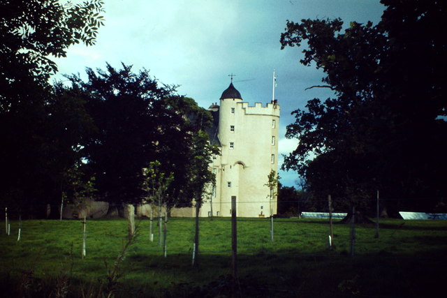
Midmar Castle is a historic landmark located in Aberdeenshire, Scotland. Situated near the village of Echt, it is a well-preserved example of a 16th-century tower house. This iconic structure was originally built in the 1560s by the Reid family, who were prominent landowners in the area.

The castle features a rectangular plan with four stories, each accessed by a spiral stone staircase. It is constructed with local granite, giving it a sturdy and imposing appearance. The entrance is adorned with a striking archway, and the exterior is adorned with crow-stepped gables and small turrets.

Over the centuries, Midmar Castle has undergone various modifications and additions, reflecting the changing needs and tastes of its owners. In the 18th century, a Georgian wing was added, expanding the living space within the castle. The interiors of the castle boast intricate woodwork, ornate plaster ceilings, and a collection of antique furniture and artwork.

Midmar Castle is surrounded by picturesque gardens and a beautiful landscape, making it a popular tourist destination. Visitors can explore the castle's grounds, which include a walled garden, a pond, and lush green lawns. The castle also offers guided tours, providing visitors with a glimpse into the rich history and architectural beauty of the site.

Today, Midmar Castle is recognized as a Category A listed building and a designated heritage site. It stands as a testament to the architectural prowess of its time and serves as a reminder of Scotland's rich cultural heritage.

If you have any feedback on the listing, please let us know in the comments section below.

Midmar Castle Images

Images are sourced within 2km of 57.14/-2.487 or Grid Reference NJ7005. Thanks to Geograph Open Source API. All images are credited.

Minor road at Marionburgh Looking eastward.
Minor road at Marionburgh
Looking eastward.
Minor road approaching Bents Looking north-westward.
Minor road approaching Bents
Looking north-westward.
Tree-lined minor road near to Hillhead Looking northward.
Tree-lined minor road near to Hillhead
Looking northward.
Track that gives access to North Tilldaff Looking eastward.
Track that gives access to North Tilldaff
Looking eastward.
View from the Hill of Fare Or, to be more specific, the view from one of the tracks on the Hill of Fare, north towards the Mither Tap of Bennachie.
View from the Hill of Fare
Or, to be more specific, the view from one of the tracks on the Hill of Fare, north towards the Mither Tap of Bennachie.
Christ Church and part of its Burial Ground, Midmar Viewed from the south-east.
Christ Church and part of its Burial Ground, Midmar
Viewed from the south-east.
Ordnance Survey Cut Mark This mark can be found on the wall of Christ Church, Midmar.
The recorded details give a height of 200.5361 metres above sea level.
For more detail see : <span class="nowrap"><a title="https://www.bench-marks.org.uk/bm163566" rel="nofollow ugc noopener" href="https://www.bench-marks.org.uk/bm163566">Link</a><img style="margin-left:2px;" alt="External link" title="External link - shift click to open in new window" src="https://s1.geograph.org.uk/img/external.png" width="10" height="10"/></span>
Ordnance Survey Cut Mark
This mark can be found on the wall of Christ Church, Midmar. The recorded details give a height of 200.5361 metres above sea level. For more detail see : LinkExternal link
Midmar Castle One of the celebrated Castles of Mar. It is a 16th century tower house and a former Gordon stronghold. 
<span class="nowrap"><a title="http://en.wikipedia.org/wiki/Midmar_Castle" rel="nofollow ugc noopener" href="http://en.wikipedia.org/wiki/Midmar_Castle">Link</a><img style="margin-left:2px;" alt="External link" title="External link - shift click to open in new window" src="https://s1.geograph.org.uk/img/external.png" width="10" height="10"/></span>
Midmar Castle
One of the celebrated Castles of Mar. It is a 16th century tower house and a former Gordon stronghold. LinkExternal link
Gateway to Midmar Castle (disused) Off B9119.
Gateway to Midmar Castle (disused)
Off B9119.
Path to Midmar Old Kirk From the B9119, over a wee headwater of the Gormack Burn.
Path to Midmar Old Kirk
From the B9119, over a wee headwater of the Gormack Burn.
The eastern gable end, Midmar Old Kirk View of the roofless Old Kirk at Midmar; seen from its small graveyard.
The eastern gable end, Midmar Old Kirk
View of the roofless Old Kirk at Midmar; seen from its small graveyard.
Sherritt-Duff memorial headstones in Midmar Old Kirk
Cunningar Motte, Midmar Far right; seen from the chained exit from Midmar Old Kirk. The front right gravestone, erected in 1871 by James McIntosh, is in memory of several of his children who had died in infancy, with his wife and his own death and burial here in 1915 subsequently added. The last of the family included on the stone is that of a Helen Mary who died in 1977.
Cunningar Motte, Midmar
Far right; seen from the chained exit from Midmar Old Kirk. The front right gravestone, erected in 1871 by James McIntosh, is in memory of several of his children who had died in infancy, with his wife and his own death and burial here in 1915 subsequently added. The last of the family included on the stone is that of a Helen Mary who died in 1977.
Sunhoney Recumbent Stone Circle (1) The circle at Sunhoney is complete, with nine stones in the circle besides the recumbent and flankers, all still standing. This is the first view of the circle from the access path. See <span class="nowrap"><a title="http://canmore.rcahms.gov.uk/en/site/18543/details/sunhoney/" rel="nofollow ugc noopener" href="http://canmore.rcahms.gov.uk/en/site/18543/details/sunhoney/">Link</a><img style="margin-left:2px;" alt="External link" title="External link - shift click to open in new window" src="https://s1.geograph.org.uk/img/external.png" width="10" height="10"/></span> for a full description. <a href="https://www.geograph.org.uk/photo/4447078">NJ7105 : Sunhoney Recumbent Stone Circle (2)</a>
Sunhoney Recumbent Stone Circle (1)
The circle at Sunhoney is complete, with nine stones in the circle besides the recumbent and flankers, all still standing. This is the first view of the circle from the access path. See LinkExternal link for a full description. NJ7105 : Sunhoney Recumbent Stone Circle (2)
Sunhoney Recumbent Stone Circle (2) These are the recumbent and flankers. The recumbent is not in its original position; it is lying on its face, so what is now the upper surface originally faced the centre of the circle. It has been moved into its present position during a restoration of the circle. See <span class="nowrap"><a title="http://canmore.rcahms.gov.uk/en/site/18543/details/sunhoney/" rel="nofollow ugc noopener" href="http://canmore.rcahms.gov.uk/en/site/18543/details/sunhoney/">Link</a><img style="margin-left:2px;" alt="External link" title="External link - shift click to open in new window" src="https://s1.geograph.org.uk/img/external.png" width="10" height="10"/></span> for a full description. <a href="https://www.geograph.org.uk/photo/4447090">NJ7105 : Sunhoney Recumbent Stone Circle (3)</a>
Sunhoney Recumbent Stone Circle (2)
These are the recumbent and flankers. The recumbent is not in its original position; it is lying on its face, so what is now the upper surface originally faced the centre of the circle. It has been moved into its present position during a restoration of the circle. See LinkExternal link for a full description. NJ7105 : Sunhoney Recumbent Stone Circle (3)
Sunhoney Recumbent Stone Circle (3) Looking into the circle from the south-west. The recumbent and flankers are right of centre. See <span class="nowrap"><a title="http://canmore.rcahms.gov.uk/en/site/18543/details/sunhoney/" rel="nofollow ugc noopener" href="http://canmore.rcahms.gov.uk/en/site/18543/details/sunhoney/">Link</a><img style="margin-left:2px;" alt="External link" title="External link - shift click to open in new window" src="https://s1.geograph.org.uk/img/external.png" width="10" height="10"/></span> for a full description. <a href="https://www.geograph.org.uk/photo/4447098">NJ7105 : Sunhoney Recumbent Stone Circle (4)</a>
Sunhoney Recumbent Stone Circle (3)
Looking into the circle from the south-west. The recumbent and flankers are right of centre. See LinkExternal link for a full description. NJ7105 : Sunhoney Recumbent Stone Circle (4)
Sunhoney Recumbent Stone Circle (4) The flankers and recumbent, from the south-west. See <span class="nowrap"><a title="http://canmore.rcahms.gov.uk/en/site/18543/details/sunhoney/" rel="nofollow ugc noopener" href="http://canmore.rcahms.gov.uk/en/site/18543/details/sunhoney/">Link</a><img style="margin-left:2px;" alt="External link" title="External link - shift click to open in new window" src="https://s1.geograph.org.uk/img/external.png" width="10" height="10"/></span> for a full description. <a href="https://www.geograph.org.uk/photo/4447106">NJ7105 : Sunhoney Recumbent Stone Circle (5)</a>
Sunhoney Recumbent Stone Circle (4)
The flankers and recumbent, from the south-west. See LinkExternal link for a full description. NJ7105 : Sunhoney Recumbent Stone Circle (5)
Sunhoney Recumbent Stone Circle (5) These are the stones in the northern arc of the circle. See <span class="nowrap"><a title="http://canmore.rcahms.gov.uk/en/site/18543/details/sunhoney/" rel="nofollow ugc noopener" href="http://canmore.rcahms.gov.uk/en/site/18543/details/sunhoney/">Link</a><img style="margin-left:2px;" alt="External link" title="External link - shift click to open in new window" src="https://s1.geograph.org.uk/img/external.png" width="10" height="10"/></span> for a full description. <a href="https://www.geograph.org.uk/photo/4447115">NJ7105 : Sunhoney Recumbent Stone Circle (6)</a>
Sunhoney Recumbent Stone Circle (5)
These are the stones in the northern arc of the circle. See LinkExternal link for a full description. NJ7105 : Sunhoney Recumbent Stone Circle (6)
Show me another place!

Midmar Castle is located at Grid Ref: NJ7005 (Lat: 57.14, Lng: -2.487)

What 3 Words

///flattered.column.crash. Near Sauchen, Aberdeenshire

Nearby Locations

Midmar Castle

Related Wikis

Midmar Castle

Midmar Castle is a 16th-century castle in Aberdeenshire, Scotland, located 12 kilometres (7.5 mi) west of Westhill and 3.5 kilometres (2.2 mi) west of...
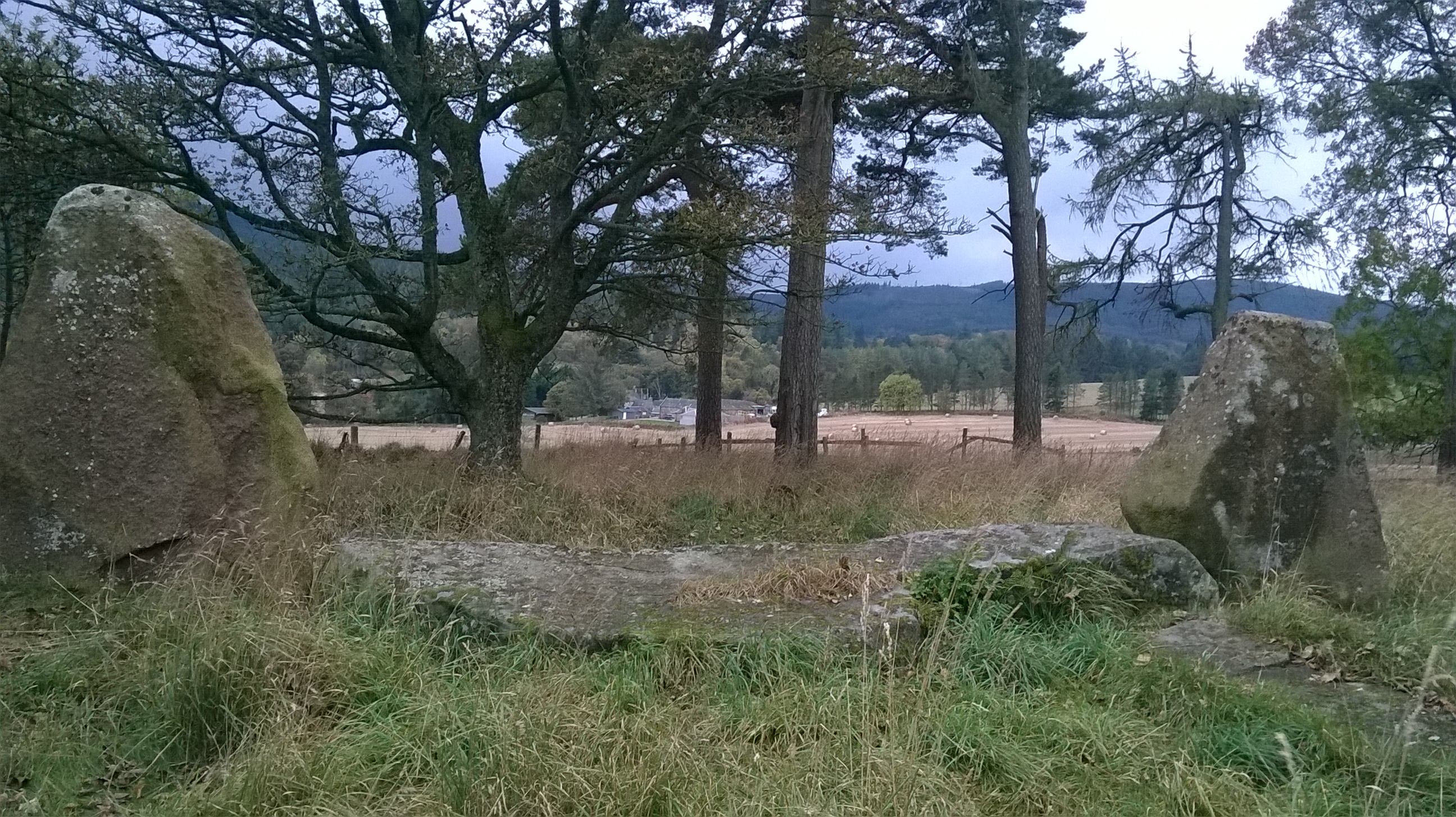
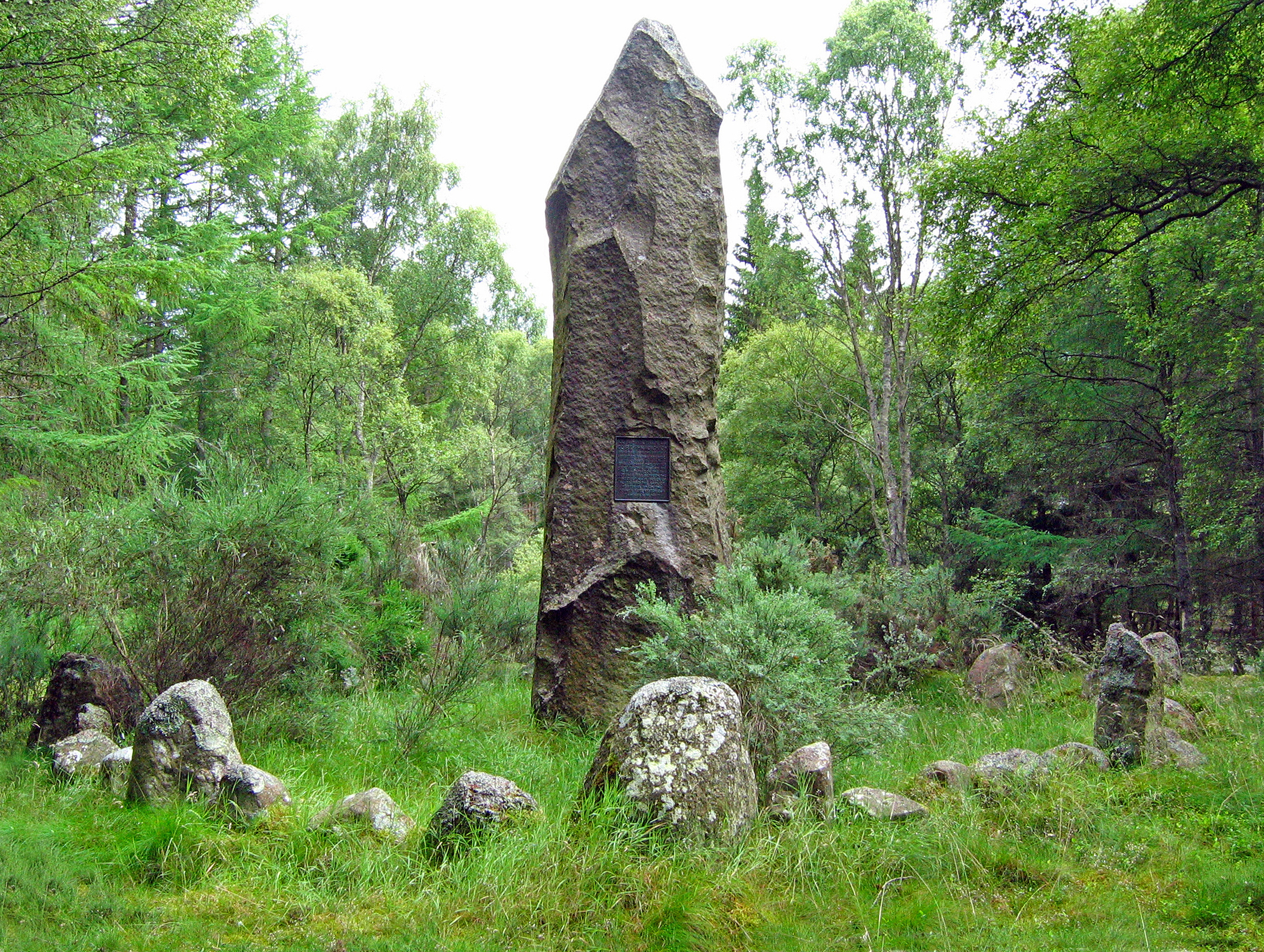
Sunhoney

Sunhoney is a stone circle of the recumbent type, which is common in the Grampian region, in particular at the River Dee. Sunhoney is situated about 2...

Midmar

Midmar is a historic settlement in Aberdeenshire, lying north of Banchory and southwest of Inverurie. It is noted for its three stone circles and various...

Echt, Aberdeenshire

Echt (Scottish Gaelic: Eicht) is an Aberdeenshire crossroads village in northeast Scotland with a population of approximately 300 people. Echt has a number...

Corsindae House

Corsindae House is a 16th-century castle, originally L-plan, about 8 miles (13 km) north of Banchory, Aberdeenshire, Scotland, and 1 mile (1.6 km) north...

Hill of Fare

The Hill of Fare is a small hill in Aberdeenshire, Scotland. It is located about 5 km (3 miles) northeast of the village of Torphins. The hill is long...

Battle of Corrichie

The Battle of Corrichie, also known as the Battle of Corrichy was a battle fought near Meikle Tap, near Aberdeen, Scotland, on 28 October 1562. It was...

Dunecht estate

The Dunecht Estate is one of the largest private estates in Aberdeenshire, Scotland at 53,000 acres (210 km2). It is owned by The Hon Charles Anthony...

Nearby Amenities

Located within 500m of 57.14,-2.487
Power: pole
Lat/Long: 57.1419729/-2.4804883
Power: pole
Lat/Long: 57.1420143/-2.4819463
Power: pole
Lat/Long: 57.1420445/-2.4832496
Power: pole
Lat/Long: 57.142068/-2.4843838
Power: pole
Lat/Long: 57.1421082/-2.4858685
Power: pole
Lat/Long: 57.1421373/-2.4872151
Power: pole
Lat/Long: 57.1421776/-2.4886277
Power: pole
Lat/Long: 57.1422179/-2.4899908
Power: pole
Lat/Long: 57.1422526/-2.4913106
Power: pole
Lat/Long: 57.1422671/-2.4921541
Power: pole
Lat/Long: 57.1422682/-2.4931027
Power: pole
Lat/Long: 57.1378142/-2.4905182
Power: pole
Lat/Long: 57.1382749/-2.4905827
Power: pole
Lat/Long: 57.1388777/-2.490654
Power: pole
Lat/Long: 57.1394612/-2.4907198
Power: pole
Lat/Long: 57.1403134/-2.4908296
Power: pole
Lat/Long: 57.1406498/-2.4900587
Power: pole
Lat/Long: 57.1408358/-2.4896527
Power: pole
Lat/Long: 57.1386619/-2.4940873
The data included in this document is from www.openstreetmap.org. The data is made available under ODbL.

Have you been to Midmar Castle?

Leave your review of Midmar Castle below (or comments, questions and feedback).