Load Bridge

Heritage Site in Somerset South Somerset

England

Load Bridge

Town Tree Lane
Town Tree Lane Credit: Sarah Charlesworth

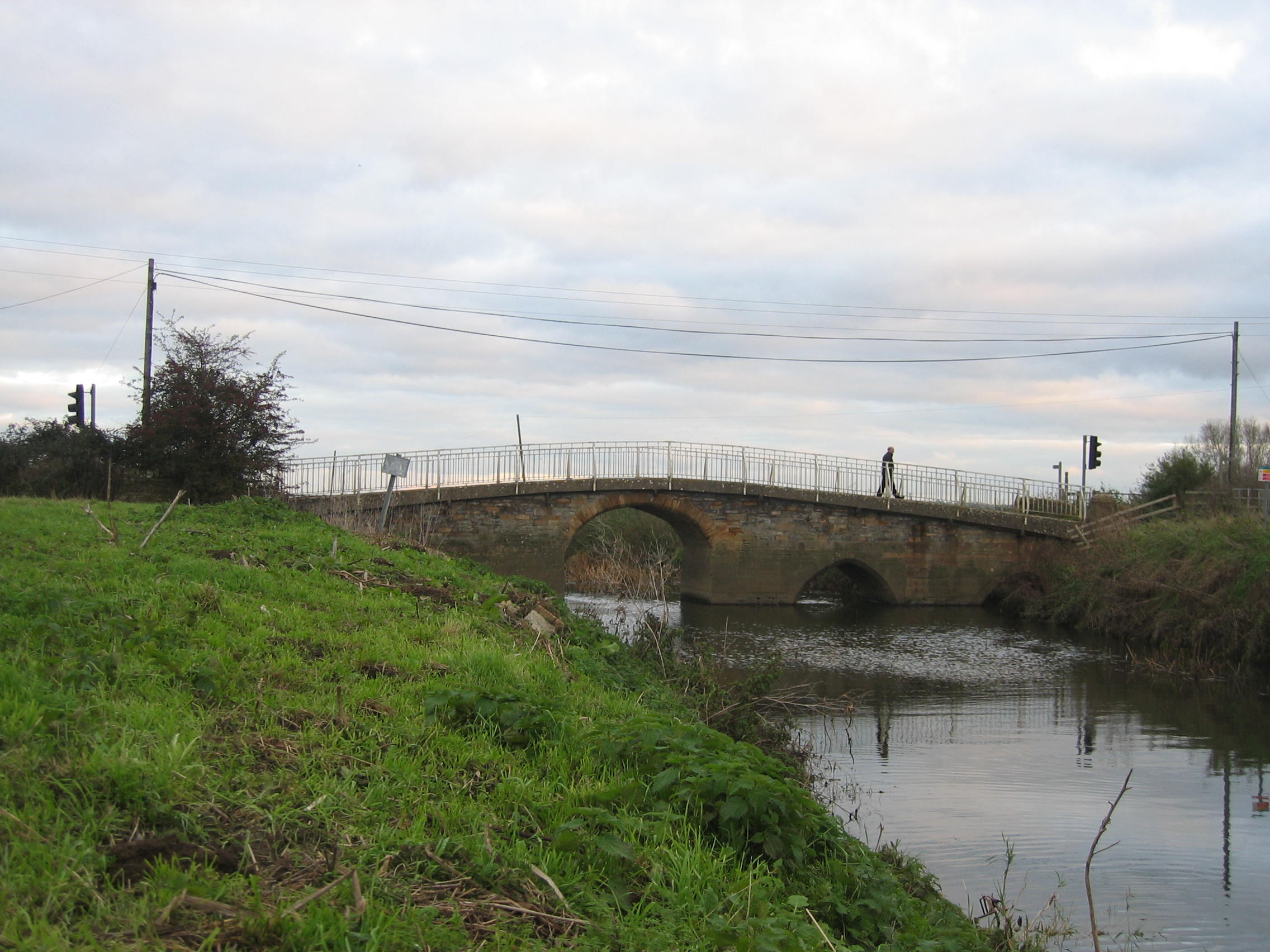
Load Bridge, Somerset is a historic and picturesque bridge situated in the county of Somerset, England. Spanning the River Parrett, this heritage site holds significant historical and architectural value. The bridge is located near the village of Load, in close proximity to the town of Bridgwater.

Load Bridge is believed to have been constructed during the medieval period, with its exact origins dating back to the 14th century. It was an essential crossing point for travelers and merchants during the medieval and early modern eras, connecting various towns and villages in the region. The bridge provided a vital link between Somerset and Devon, facilitating trade and commerce.

Architecturally, Load Bridge is an excellent example of a stone arch bridge, characterized by its sturdy construction and elegant design. The structure consists of three arches, supported by robust piers, and features a parapet adorned with stone balusters. The bridge is built predominantly with local limestone, showcasing the region's natural resources and craftsmanship.

Today, Load Bridge serves as a beloved landmark and a testament to Somerset's rich history. It continues to be an important thoroughfare for both vehicular and pedestrian traffic, connecting nearby communities and offering breathtaking views of the surrounding countryside. Visitors can also appreciate the tranquility of the river and enjoy the picturesque scenery that the bridge provides.

Load Bridge, Somerset is not only a vital transportation route but also a cherished heritage site that stands as a reminder of the region's architectural and historical legacy. It is a popular destination for history enthusiasts, photographers, and those seeking a glimpse into the past.

If you have any feedback on the listing, please let us know in the comments section below.

Load Bridge Images

Images are sourced within 2km of 51.008/-2.763 or Grid Reference ST4623. Thanks to Geograph Open Source API. All images are credited.

Town Tree Lane
Town Tree Lane
B3165 north of Stapleton (aka Long Load Road)
Sharp bend on the B3165 in Long Sutton
Farmland, Stapleton There is a gas pipeline marker in the hedge.
Farmland, Stapleton
There is a gas pipeline marker in the hedge.
Cattle by Mare Grove Mare Grove is the lane between hedges on the far side of the field.
Cattle by Mare Grove
Mare Grove is the lane between hedges on the far side of the field.
A dense hedgerow A big hedge off Long Load Road.
A dense hedgerow
A big hedge off Long Load Road.
Old school building, Long Load An 1872 Education Act village school building.
Old school building, Long Load
An 1872 Education Act village school building.
B3165, Long Load Martock to Somerton road.
B3165, Long Load
Martock to Somerton road.
Lost gate From the days when the land beyond the overgrown hedge was agricultural, it's a golf course now.
Lost gate
From the days when the land beyond the overgrown hedge was agricultural, it's a golf course now.
Lame Hill An arable field with some structure in the far boundary, probably a service reservoir.
Lame Hill
An arable field with some structure in the far boundary, probably a service reservoir.
Lame Hill A small clump of trees and what appears to be a water tank on the far side of a field.
Lame Hill
A small clump of trees and what appears to be a water tank on the far side of a field.
Site of a building, Sutton Hill An enclosure with the remains of a building.
Site of a building, Sutton Hill
An enclosure with the remains of a building.
Green and Devonshire Arms Village green, Long Sutton.
Green and Devonshire Arms
Village green, Long Sutton.
Circular bench, Long Sutton Tree, probably commemorative of a hatch, match, dispatch or job appointment in a certain family, on the green at Long Sutton.
Circular bench, Long Sutton
Tree, probably commemorative of a hatch, match, dispatch or job appointment in a certain family, on the green at Long Sutton.
Long Sutton This 19th century building looks like it was the village school once.
Long Sutton
This 19th century building looks like it was the village school once.
B3165, Long Sutton A tractor passes the village green.
B3165, Long Sutton
A tractor passes the village green.
War memorial, Long Sutton
Knightlands Lane, Long Sutton
Show me another place!

Load Bridge is located at Grid Ref: ST4623 (Lat: 51.008, Lng: -2.763)

Administrative County: Somerset

District: South Somerset

Police Authority: Avon and Somerset

What 3 Words

///clocks.openly.surveyors. Near Martock, Somerset

Related Wikis

Long Load

Long Load is a village and parish in Somerset, England, situated on the River Yeo 5 miles (8.0 km) south of Somerton in the South Somerset district. The...

Christ Church, Long Load

Christ Church is a former Church of England church in Long Load, Somerset, England. Designed by Charles Edmund Giles, it was built in 1854–1856 on the...

Long Sutton, Somerset

Long Sutton is a village and civil parish in Somerset, England, situated 4 miles (6.4 km) south of Somerton in the South Somerset district. The village...

Wet Moor

Wet Moor (grid reference ST448244) is a 491.0-hectare (1214.0 acre) biological Site of Special Scientific Interest east of Muchelney in Somerset, notified...

Church of the Holy Trinity, Long Sutton

The Church of the Holy Trinity in Long Sutton, Somerset, England dates from the 15th century and has been designated as a Grade I listed building.An earlier...

Ash, South Somerset

Ash is a village and parish in Somerset, England, situated 1 mile (1.6 km) from Martock and 6 miles (9.7 km) north-west of Yeovil. The parish has a population...

Pill Bridge

Pill Bridge is a stone arch bridge over the River Yeo between the parishes of Ilchester and Long Sutton, in the English county of Somerset. It is a scheduled...

Long Sutton and Pitney railway station

Long Sutton and Pitney railway station was a minor railway station situated in the hamlet of Upton, Somerset, about one mile equidistant from the two larger...

Nearby Amenities

Located within 500m of 51.008,-2.763
Long Load
Place: village
Source: npe
Lat/Long: 51.0055684/-2.7631847
Traffic Signals
Lat/Long: 51.0106489/-2.761188
Traffic Signals
Lat/Long: 51.0113599/-2.7608587
Power: pole
Source: bing
Lat/Long: 51.0096075/-2.7614267
Power: pole
Source: bing
Lat/Long: 51.0092582/-2.761534
Power: pole
Source: bing
Lat/Long: 51.0100623/-2.7612269
Power: pole
Source: bing
Lat/Long: 51.0103281/-2.7611612
Power: pole
Source: bing
Lat/Long: 51.0123017/-2.7631849
Power: pole
Source: bing
Lat/Long: 51.0120275/-2.7626525
Power: pole
Source: bing
Lat/Long: 51.0117617/-2.7620544
Power: pole
Source: bing
Lat/Long: 51.0115001/-2.7614763
Power: pole
Source: bing
Lat/Long: 51.0112327/-2.7608795
Power: pole
Source: bing
Lat/Long: 51.0107686/-2.7610391
Power: pole
Source: bing
Lat/Long: 51.0109213/-2.7590134
Power: pole
Source: bing
Lat/Long: 51.0110715/-2.7581424
Power: pole
Source: bing
Lat/Long: 51.0102682/-2.757099
Poles: bipole
Power: pole
Source: bing
Lat/Long: 51.0096809/-2.757158
Power: pole
Source: bing
Lat/Long: 51.0089384/-2.7572411
Power: pole
Source: bing
Lat/Long: 51.0082599/-2.7573109
Power: pole
Source: bing
Lat/Long: 51.0075595/-2.7573752
Power: pole
Source: bing
Lat/Long: 51.0068068/-2.7574584
Power: pole
Source: bing
Lat/Long: 51.0054094/-2.7576113
Power: pole
Source: bing
Lat/Long: 51.006098/-2.7575375
Power: pole
Source: bing
Lat/Long: 51.0061208/-2.7587405
Power: pole
Source: bing
Lat/Long: 51.0061436/-2.7598724
Power: pole
Source: bing
Transformer: distribution
Lat/Long: 51.0061976/-2.762112
Power: pole
Source: bing
Lat/Long: 51.0061646/-2.7609131
Power: pole
Source: bing
Lat/Long: 51.0071326/-2.7608661
Power: pole
Source: bing
Lat/Long: 51.0079325/-2.761007
Power: pole
Source: bing
Lat/Long: 51.0086295/-2.7611491
Power: pole
Source: bing
Lat/Long: 51.0090228/-2.7612363
Power: pole
Source: bing
Transformer: distribution
Lat/Long: 51.0053748/-2.7648774
Power: pole
Source: bing
Lat/Long: 51.0047646/-2.7653857
Power: pole
Source: bing
Lat/Long: 51.0040397/-2.7659972
The data included in this document is from www.openstreetmap.org. The data is made available under ODbL.

Have you been to Load Bridge?

Leave your review of Load Bridge below (or comments, questions and feedback).