Llangattock Court

Heritage Site in Brecknockshire

Wales

Llangattock Court

Ordnance Survey Cut Mark This OS cut mark can be found on Perth House. It marks a point 205.700m above mean sea level.
Ordnance Survey Cut Mark Credit: Adrian Dust

Llangattock Court is a historic heritage site located in the county of Brecknockshire, Wales. Situated in the scenic Usk Valley, this magnificent manor house dates back to the 17th century and is renowned for its architectural beauty and historical significance.

The main house of Llangattock Court is a Grade I listed building, recognized for its exceptional preservation and architectural merit. The exterior showcases a stunning combination of medieval and Georgian elements, with a symmetrical façade, grand windows, and a prominent central entrance. The interior of the house boasts an impressive collection of original features, including ornate plasterwork, intricate wood carvings, and elegant fireplaces.

The estate surrounding Llangattock Court is equally notable, with picturesque gardens and extensive parkland. The gardens offer a diverse range of landscaping styles, from formal terraces to wildflower meadows, and are known for their abundance of rare and exotic plants. The parkland, with its rolling hills and ancient trees, provides a tranquil setting for leisurely walks and picnics.

Throughout its history, Llangattock Court has been associated with several prominent families and figures, including the Morgan family, who were influential landowners in the area. The house also played a role during the English Civil War, serving as a garrison for Parliamentary forces.

Today, Llangattock Court stands as a testament to the rich heritage of Brecknockshire and welcomes visitors who wish to explore its grand architecture, lush gardens, and learn about its fascinating past. Guided tours are available, offering an immersive experience into the history and significance of this remarkable heritage site.

If you have any feedback on the listing, please let us know in the comments section below.

Llangattock Court Images

Images are sourced within 2km of 51.855/-3.147 or Grid Reference SO2118. Thanks to Geograph Open Source API. All images are credited.

Ordnance Survey Cut Mark This OS cut mark can be found on Perth House. It marks a point 205.700m above mean sea level.
Ordnance Survey Cut Mark
This OS cut mark can be found on Perth House. It marks a point 205.700m above mean sea level.
Entrance to South Lodge
Ffawyddog Gaer hillside enclosure as seen from Usk Valley Walk
Monmouthshire and Brecon Canal, Baylis Bridge, near Crickhowell
Root crop This is an unusual sight in this area of sheep pastures and hay fields. This crop can be used to feed sheep.
Ty Rachel is in the background.
Root crop
This is an unusual sight in this area of sheep pastures and hay fields. This crop can be used to feed sheep. Ty Rachel is in the background.
Coed y Cilau Semi-natural woodland in the valley of a mountain stream.
Coed y Cilau
Semi-natural woodland in the valley of a mountain stream.
Track by woodland The track passes along the top of the steep wooded bank of the Onnau stream, passing through sheep pastures. Field hedges were mainly absent.
Track by woodland
The track passes along the top of the steep wooded bank of the Onnau stream, passing through sheep pastures. Field hedges were mainly absent.
Tree stump This tree stump has given protection to young hawthorns sprouting in a field where sheep usually eat any new shoots in reach.
Tree stump
This tree stump has given protection to young hawthorns sprouting in a field where sheep usually eat any new shoots in reach.
Happy heifers I think these heifers of a small suckler herd were lucky to be allowed out instead of shut away for winter. Their well-drained field was not turned into a quagmire by their hooves.
Happy heifers
I think these heifers of a small suckler herd were lucky to be allowed out instead of shut away for winter. Their well-drained field was not turned into a quagmire by their hooves.
Future wood Nice to see this plantation of native trees growing well, instead of yet another boring pony paddock.
Future wood
Nice to see this plantation of native trees growing well, instead of yet another boring pony paddock.
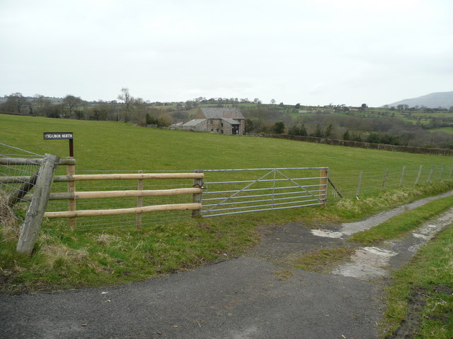
Pastures of the Usk valley This view looks over the valley south-east of Crickhowell to Sugarloaf in the distance. In the centre ground is a converted barn, Ysgubor-berth.
Pastures of the Usk valley
This view looks over the valley south-east of Crickhowell to Sugarloaf in the distance. In the centre ground is a converted barn, Ysgubor-berth.
Sheep pasture These animals are in a field on the southern slopes of the trench of the Usk valley. In the distance is a darren - cliff - on the northern flank of Twr Pen-cyrn.
Sheep pasture
These animals are in a field on the southern slopes of the trench of the Usk valley. In the distance is a darren - cliff - on the northern flank of Twr Pen-cyrn.
Ysgubor-berth A nicely converted barn with a fine view over the Usk valley.
Ysgubor-berth
A nicely converted barn with a fine view over the Usk valley.
Pen Cerrig-calch viewed across the Usk Valley Pen Cerrig-calch and Table Mountain viewed across the Usk Valley from the Usk Valley Walk near Ffawyddog.
Pen Cerrig-calch viewed across the Usk Valley
Pen Cerrig-calch and Table Mountain viewed across the Usk Valley from the Usk Valley Walk near Ffawyddog.
Sugar Loaf viewed from Ffawyddog Sugar Loaf viewed from the Usk Valley Walk above Ffawyddog.
Sugar Loaf viewed from Ffawyddog
Sugar Loaf viewed from the Usk Valley Walk above Ffawyddog.
Pen Cerrig-calch and Table Mountain Pen Cerrig-calch and Table Mountain viewed from the Usk Valley Walk near Ffawyddog.
Pen Cerrig-calch and Table Mountain
Pen Cerrig-calch and Table Mountain viewed from the Usk Valley Walk near Ffawyddog.
View across the Usk Valley to Tretower View to the north from the Usk Valley Walk near Ffawyddog. The River Usk flows through the valley in the foreground with the wooded hill named Myarth rising to the north of the river. The Rhiangoll, a tribuatary of the River Usk flows down the valley in the background, past Tretower Castle and Court which can be seen in the middle distance.
View across the Usk Valley to Tretower
View to the north from the Usk Valley Walk near Ffawyddog. The River Usk flows through the valley in the foreground with the wooded hill named Myarth rising to the north of the river. The Rhiangoll, a tribuatary of the River Usk flows down the valley in the background, past Tretower Castle and Court which can be seen in the middle distance.
Fields near Llangattock
Show me another place!

Llangattock Court is located at Grid Ref: SO2118 (Lat: 51.855, Lng: -3.147)

Unitary Authority: Powys

Police Authority: Dyfed Powys

What 3 Words

///noted.breached.surfer. Near Crickhowell, Powys

Related Wikis

Crickhowell Bridge

Crickhowell Bridge is an 18th-century bridge that spans the River Usk in Crickhowell, Powys, Wales. The main A4077 road to Gilwern crosses it. The bridge...

Llangattock, Powys

Llangattock (Welsh: Llangatwg) is a village, community and electoral ward in the Brecon Beacons National Park in Powys, Wales. It lies in the Usk Valley...

St Edmund's Church, Crickhowell

St Edmund's Church is located in Crickhowell, in southeastern Powys, Wales. Built in the early 14th century, the church is dedicated to Saint Edmund the...

Crickhowell Castle

Crickhowell Castle (Welsh: Castell Crucywel) is a Grade I listed building in Crickhowell, Wales, now largely ruined. An alternative name, "Alisby's Castle...

Nearby Amenities

Located within 500m of 51.855,-3.147
Traffic Signals
Lat/Long: 51.8570775/-3.1410968
Llangattock
Name Cy: Llangatwg
Place: village
Wikidata: Q13129643
Lat/Long: 51.8520145/-3.1472084
Toilets
Lat/Long: 51.8529223/-3.1454868
Historic: archaeological_site
Lat/Long: 51.8523273/-3.1451459
Barrier: cattle_grid
Lat/Long: 51.8519502/-3.1442165
Pub
Bridge End Inn
Real Ale: yes
Wikidata: Q29486217
Lat/Long: 51.8567224/-3.1412477
Telephone
Booth: KX100
Covered: booth
Lat/Long: 51.8525784/-3.1476742
Barrier: kissing_gate
Lat/Long: 51.8536208/-3.149495
Post Box
Ref: NP8 64
Lat/Long: 51.8572821/-3.1409837
Traffic Signals
Lat/Long: 51.8558931/-3.1428781
Traffic Signals
Lat/Long: 51.8562636/-3.143281
Post Box
Collection Times: Mo-Fr 16:00; Sa 07:30
Post Box Type: wall
Ref: NP8 59
Royal Cypher: GR
Royal Cypher Wikidata: Q33102273
Lat/Long: 51.8584594/-3.1515325
Parking
Access: customers
Parking: surface
Lat/Long: 51.8542025/-3.1501667
Telephone
Booth: KX100
Covered: booth
Lat/Long: 51.8576995/-3.1502543
Pub
The Vine Tree
Diet Vegan: yes
Diet Vegetarian: yes
Food: yes
Indoor Seating: yes
Outdoor Seating: yes
Payment Credit Cards: yes
Payment Debit Cards: yes
Wikidata: Q80858759
Lat/Long: 51.855215/-3.1421702
Access: customers
Leisure: garden
Lat/Long: 51.8565552/-3.1412327
Direction: 195
Generator Method: photovoltaic
Generator Output Electricity: yes
Generator Solar Modules: 18
Generator Source: solar
Generator Type: solar_photovoltaic_panel
Location: roof
Power: generator
Lat/Long: 51.8532169/-3.1488132
Direction: 195
Generator Method: photovoltaic
Generator Output Electricity: yes
Generator Solar Modules: 16
Generator Source: solar
Generator Type: solar_photovoltaic_panel
Location: roof
Power: generator
Lat/Long: 51.8530793/-3.1486669
Direction: 195
Generator Method: photovoltaic
Generator Output Electricity: yes
Generator Solar Modules: 16
Generator Source: solar
Generator Type: solar_photovoltaic_panel
Location: roof
Power: generator
Lat/Long: 51.8529633/-3.1485432
Direction: 195
Generator Method: photovoltaic
Generator Output Electricity: yes
Generator Solar Modules: 12
Generator Source: solar
Generator Type: solar_photovoltaic_panel
Location: roof
Power: generator
Lat/Long: 51.8531541/-3.1482429
Direction: 195
Generator Method: photovoltaic
Generator Output Electricity: yes
Generator Solar Modules: 8
Generator Source: solar
Generator Type: solar_photovoltaic_panel
Location: roof
Power: generator
Lat/Long: 51.8538157/-3.1503259
Direction: SSW
Generator Method: photovoltaic
Generator Output Electricity: yes
Generator Solar Modules: 14
Generator Source: solar
Generator Type: solar_photovoltaic_panel
Location: roof
Power: generator
Lat/Long: 51.8518347/-3.1455714
Direction: SSW
Generator Method: photovoltaic
Generator Output Electricity: yes
Generator Solar Modules: 12
Generator Source: solar
Generator Type: solar_photovoltaic_panel
Location: roof
Power: generator
Lat/Long: 51.850992/-3.14551
Direction: SW
Generator Method: photovoltaic
Generator Output Electricity: yes
Generator Solar Modules: 14
Generator Source: solar
Generator Type: solar_photovoltaic_panel
Location: roof
Power: generator
Lat/Long: 51.8507462/-3.1454131
Direction: 235
Generator Method: photovoltaic
Generator Output Electricity: yes
Generator Solar Modules: 10
Generator Source: solar
Generator Type: solar_photovoltaic_panel
Location: roof
Power: generator
Lat/Long: 51.8519979/-3.1486653
Direction: SE
Generator Method: photovoltaic
Generator Output Electricity: yes
Generator Solar Modules: 14
Generator Source: solar
Generator Type: solar_photovoltaic_panel
Location: roof
Power: generator
Lat/Long: 51.8509516/-3.1493962
Defibrillator
Emergency: defibrillator
Indoor: no
Lat/Long: 51.8528768/-3.1465209
Post Box
Operator: Royal Mail
Post Box Type: lamp
Ref: NP8 70
Royal Cypher: EIIR
Royal Cypher Wikidata: Q33102113
Lat/Long: 51.8527287/-3.1465283
Addr City: Abergavenny
Addr Housenumber: 6
Addr Postcode: NP8 1PQ
Addr Street: Church View
Addr Suburb: Llangattock
Lat/Long: 51.8535541/-3.1483199
Addr City: Abergavenny
Addr Housenumber: 4
Addr Postcode: NP8 1PQ
Addr Street: Church View
Addr Suburb: Llangattock
Lat/Long: 51.8535391/-3.1484508
Addr City: Abergavenny
Addr Housenumber: 2
Addr Postcode: NP8 1PQ
Addr Street: Church View
Addr Suburb: Llangattock
Lat/Long: 51.853528/-3.148579
Addr City: Abergavenny
Addr Housenumber: 8
Addr Postcode: NP8 1PQ
Addr Street: Church View
Addr Suburb: Llangattock
Lat/Long: 51.8535705/-3.1482176
Addr City: Abergavenny
Addr Housenumber: 12
Addr Postcode: NP8 1PQ
Addr Street: Church View
Addr Suburb: Llangattock
Lat/Long: 51.853582/-3.1480123
Addr City: Abergavenny
Addr Housenumber: 10
Addr Postcode: NP8 1PQ
Addr Street: Church View
Addr Suburb: Llangattock
Lat/Long: 51.8535764/-3.1481046
The data included in this document is from www.openstreetmap.org. The data is made available under ODbL.

Have you been to Llangattock Court?

Leave your review of Llangattock Court below (or comments, questions and feedback).