Craig y Castell

Heritage Site in Merionethshire

Wales

Craig y Castell

Afon Wnion Near Dolgellau The Wnion joins the Mawddach just above the tidal limit of the Mawddach estuary.
Afon Wnion Near Dolgellau Credit: David Robinson

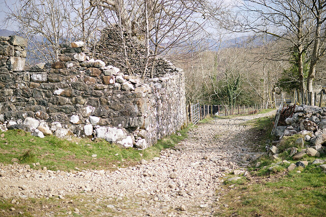
Craig y Castell is a historic heritage site located in Merionethshire, Wales. Situated on a hilltop, it offers breathtaking views of the surrounding landscape. The site consists of the remains of a medieval castle, which was once a significant stronghold in the region.

The castle was constructed in the 13th century and played a crucial role in defending the area against invasions. It was strategically positioned to overlook the surrounding valleys, providing an advantageous vantage point for its occupants. The castle's ruins, which include the remains of a tower and defensive walls, are a testament to its former grandeur.

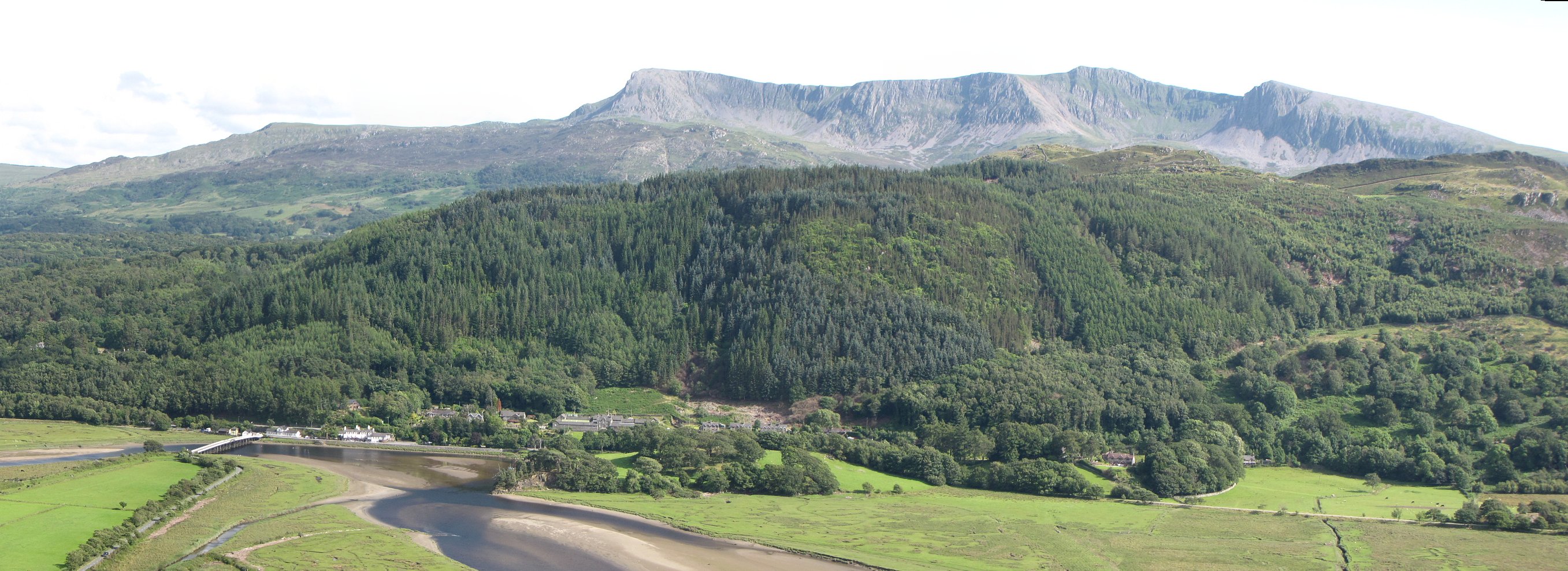
Visitors to Craig y Castell can explore the site and imagine what life would have been like in medieval times. The castle's layout and architectural features provide insights into its defensive capabilities and the living conditions of its inhabitants. The panoramic views from the hilltop also offer a glimpse into the castle's strategic importance.

In addition to its historical significance, Craig y Castell is also a popular destination for outdoor enthusiasts. The site is surrounded by picturesque hiking trails, allowing visitors to enjoy the natural beauty of the Welsh countryside. The combination of history and stunning scenery makes Craig y Castell a must-visit destination for both history buffs and nature lovers alike.

Overall, Craig y Castell is a captivating heritage site that showcases the rich history and natural splendor of Merionethshire. Its medieval castle ruins and panoramic views make it an ideal destination for those seeking to immerse themselves in the past and marvel at the beauty of the Welsh landscape.

If you have any feedback on the listing, please let us know in the comments section below.

Craig y Castell Images

Images are sourced within 2km of 52.738/-3.933 or Grid Reference SH6917. Thanks to Geograph Open Source API. All images are credited.

Afon Wnion Near Dolgellau The Wnion joins the Mawddach just above the tidal limit of the Mawddach estuary.
Afon Wnion Near Dolgellau
The Wnion joins the Mawddach just above the tidal limit of the Mawddach estuary.
A minor road leading to Gellilwyd Fawr Which provides access to the green lane over the hills to Kings Youth Hostel.
A minor road leading to Gellilwyd Fawr
Which provides access to the green lane over the hills to Kings Youth Hostel.
On the lane to Gellilwyd Fach
Passing through Gellilwyd Fawr Farm This is the start of a green lane over the hills to Kings Youth Hostel. The OS route mark the route with green dots as an 'other route' open to all vehicles, but I would suggest that you not try it with a four-wheel drive! Motorcycles would find it an interesting challenge. The route crosses access land as far as Hafod-dywyll. The stile in the view has been dispensed with - access is through the gate.
Passing through Gellilwyd Fawr Farm
This is the start of a green lane over the hills to Kings Youth Hostel. The OS route mark the route with green dots as an 'other route' open to all vehicles, but I would suggest that you not try it with a four-wheel drive! Motorcycles would find it an interesting challenge. The route crosses access land as far as Hafod-dywyll. The stile in the view has been dispensed with - access is through the gate.
A ruined barn at Gellilwyd Fawr Viewed from the start of the green lane over the hills to Kings Youth Hostel.
A ruined barn at Gellilwyd Fawr
Viewed from the start of the green lane over the hills to Kings Youth Hostel.
A track on Gellilwyd Farm This is a right of way leading south to Llyn Gwernan. It is not the green lane to Kings.
A track on Gellilwyd Farm
This is a right of way leading south to Llyn Gwernan. It is not the green lane to Kings.
On the green lane up from Gellilwyd Fawr Looking back down the steep hill that rises from the farm.
On the green lane up from Gellilwyd Fawr
Looking back down the steep hill that rises from the farm.
Pasture above Gellilwyd This is all access land. Cadair Idris in the distance.
Pasture above Gellilwyd
This is all access land. Cadair Idris in the distance.
Ex-railway bridge crossing Afon Wnion Afon Wnion is a tributary of Afon Mawddach which it joins about half a mile to the right. The bridge now carries the Mawddach Trail, which runs to Morfa Mawddach on the Mawddach estuary.
Ex-railway bridge crossing Afon Wnion
Afon Wnion is a tributary of Afon Mawddach which it joins about half a mile to the right. The bridge now carries the Mawddach Trail, which runs to Morfa Mawddach on the Mawddach estuary.
Walkers on the Mawddach Trail Bright sunshine but a cold wind.
Walkers on the Mawddach Trail
Bright sunshine but a cold wind.
Ordnance Survey Cut Mark This OS cut mark can be found on the wall NE side of the road. It marks a point 6.482m above mean sea level.
Ordnance Survey Cut Mark
This OS cut mark can be found on the wall NE side of the road. It marks a point 6.482m above mean sea level.
The west end of Llyn Gwernan An attractive pool of water nestling in a bit of a hollow. The mountain in the distance is Rhobell Fawr.
The west end of Llyn Gwernan
An attractive pool of water nestling in a bit of a hollow. The mountain in the distance is Rhobell Fawr.
View west from above Tyddyn Mawr Looking over fields to the distant crags of Pared y Cefn Hir.
View west from above Tyddyn Mawr
Looking over fields to the distant crags of Pared y Cefn Hir.
Woodland path The path here is narrow and steep but very verdant in June after a little rain.
Woodland path
The path here is narrow and steep but very verdant in June after a little rain.
Ladder stile on the edge of the woods At the end of a steepish path up through the woods stands this stile.
Ladder stile on the edge of the woods
At the end of a steepish path up through the woods stands this stile.
Secluded cottage What a spot this cottage occupies.
Secluded cottage
What a spot this cottage occupies.
Llyn Gwernan's east shore Taken from the new path that goes round the lake
Llyn Gwernan's east shore
Taken from the new path that goes round the lake
Isolated trees on grassy moorland The location is south-west of Dolgellau. The hill beyond rises to over 500m but appears unnamed on OS maps; it's just a minor outlier of the Cadair Idris range with little prominence of its own.
Isolated trees on grassy moorland
The location is south-west of Dolgellau. The hill beyond rises to over 500m but appears unnamed on OS maps; it's just a minor outlier of the Cadair Idris range with little prominence of its own.
Show me another place!

Craig y Castell is located at Grid Ref: SH6917 (Lat: 52.738, Lng: -3.933)

What 3 Words

///baroness.active.budgeted. Near Dolgellau, Gwynedd

Nearby Locations

Craig y Castell

Related Wikis

Penmaenpool

Penmaenpool (Welsh: Llynpenmaen) is a hamlet on the south side of the estuary of the River Mawddach in Wales, near Dolgellau. A Grade II listed toll bridge...

Penmaenpool railway station

Penmaenpool railway station at Penmaenpool in Gwynedd, North Wales, was formerly a station on the Dolgelly [sic] branch of the Aberystwith and Welsh Coast...
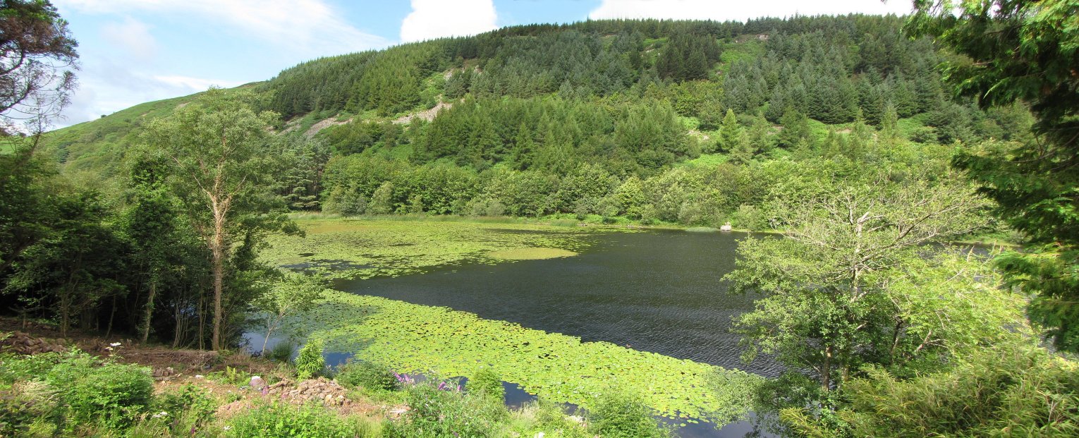
Llyn Gwernan

Llyn Gwernan is a lake in Gwynedd, Wales and an important geological site, notable for an unusual thickness of Devensian Late-glacial organic deposits...

Borthwnog

Borthwnog is a family name given to the Borthwnog estate in Gwynedd, north-west Wales. Borthwnog Hall was the Manor House of the estate which encompassed...

Nearby Amenities

Located within 500m of 52.738,-3.933
Barrier: stile
Material: wood
Step Count: 6
Stile: ladder
Lat/Long: 52.7396622/-3.9371182
Craig Y Castell
Ele: 298
Natural: peak
Lat/Long: 52.7375903/-3.9357855
Barrier: stile
Material: wood
Step Count: 5
Stile: ladder
Lat/Long: 52.7403015/-3.9295368
Barrier: stile
Material: wood
Step Count: 5
Stile: ladder
Lat/Long: 52.7404164/-3.9346981
Ford: yes
Lat/Long: 52.7404342/-3.9346981
The data included in this document is from www.openstreetmap.org. The data is made available under ODbL.

Have you been to Craig y Castell?

Leave your review of Craig y Castell below (or comments, questions and feedback).