Columbine Hall

Heritage Site in Suffolk

England

Columbine Hall

Columbine Hall Columbine Hall was built in about 1390 probably by Richard Hotot. It was originally larger; what remains now is the gatehouse range. There have been various owners over the centuries and for many years it was used as a farm; during the Second World War landgirls were trained here. Today it remains in private ownership but guided tours are available on certain dates, see <span class="nowrap"><a title="https://www.columbinehall.co.uk/guided-tours/" rel="nofollow ugc noopener" href="https://www.columbinehall.co.uk/guided-tours/">Link</a><img style="margin-left:2px;" alt="External link" title="External link - shift click to open in new window" src="https://s1.geograph.org.uk/img/external.png" width="10" height="10"/></span>.
Columbine Hall Credit: Stephen McKay

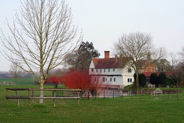
Columbine Hall, located in Suffolk, England, is a historically significant heritage site that dates back to the 14th century. This Grade I listed building stands as a testament to the medieval architecture and rich history of the region. The hall is situated in a tranquil setting, surrounded by picturesque gardens and sprawling countryside.

The main structure of Columbine Hall consists of a striking timber-framed building with a thatched roof, which has been meticulously preserved over the centuries. The hall features a symmetrical layout with a central hall flanked by two wings. The interior boasts a wealth of original features, including exposed beams, intricate woodwork, and a magnificent fireplace that exudes a sense of grandeur.

Throughout its long and storied history, Columbine Hall has undergone various renovations and additions, showcasing different architectural styles from different eras. Notably, the east wing was added in the 17th century, incorporating elements of Jacobean design.

The hall is surrounded by beautifully landscaped gardens, with manicured lawns, flowerbeds, and a charming courtyard. The gardens offer visitors a peaceful retreat, with scenic views of the surrounding countryside.

Columbine Hall has also served as a home to several notable families throughout the centuries, contributing to its historical significance. Today, the hall is privately owned and closed to the public, preserving its unique atmosphere and historical integrity.

In summary, Columbine Hall is a remarkable heritage site that offers a glimpse into the architectural and cultural heritage of Suffolk. With its medieval origins, breathtaking features, and stunning surroundings, it stands as a testament to the region's rich history and enduring beauty.

If you have any feedback on the listing, please let us know in the comments section below.

Columbine Hall Images

Images are sourced within 2km of 52.203/1.022 or Grid Reference TM0660. Thanks to Geograph Open Source API. All images are credited.

Columbine Hall Columbine Hall was built in about 1390 probably by Richard Hotot. It was originally larger; what remains now is the gatehouse range. There have been various owners over the centuries and for many years it was used as a farm; during the Second World War landgirls were trained here. Today it remains in private ownership but guided tours are available on certain dates, see <span class="nowrap"><a title="https://www.columbinehall.co.uk/guided-tours/" rel="nofollow ugc noopener" href="https://www.columbinehall.co.uk/guided-tours/">Link</a><img style="margin-left:2px;" alt="External link" title="External link - shift click to open in new window" src="https://s1.geograph.org.uk/img/external.png" width="10" height="10"/></span>.
Columbine Hall
Columbine Hall was built in about 1390 probably by Richard Hotot. It was originally larger; what remains now is the gatehouse range. There have been various owners over the centuries and for many years it was used as a farm; during the Second World War landgirls were trained here. Today it remains in private ownership but guided tours are available on certain dates, see LinkExternal link.
Cereal crop, Newton Bridge
Junction on a bend of the B1113, Newton Bridge
Cereal crop and hedgerow off Stonebridge Lane
Gated track off Stonebridge Lane
Stonebridge Lane towards Old Newton
Cereal crop towards the River Gipping
Stonebridge Lane towards Old Newton
Barn, Colt Meadow Farm
Farmland off Stonebridge Lane
Stonebridge Lane towards Old Newton
Farm buildings, Hill Farm
Cereal crop near Hill Farm
School Road, Old Newton
Cereal crop and pylon
Rendall Lane
Rendall Lane
Barn under construction, Stowupland
Bungalows, Stowupland
Show me another place!

Columbine Hall is located at Grid Ref: TM0660 (Lat: 52.203, Lng: 1.022)

What 3 Words

///reason.headstone.today. Near Stowmarket, Suffolk

Nearby Locations

Columbine Hall

Related Wikis

Stowupland High School

Stowupland High School is a co-educational secondary school and sixth form situated in the Suffolk village Stowupland. It caters for students aged 11–18...

Stowupland

Stowupland is a village 1 mile (2 km) east of Stowmarket, Suffolk, England. Stowupland means "a place occupied on higher ground than Stowmarket", with...

Stow Hundred

Stow was a hundred of Suffolk, consisting of 22,710 acres (91.9 km2).Stow Hundred a fertile and picturesque district in central Suffolk around seven miles...

Suffolk

Suffolk ( SUF-ək) is a ceremonial county in the East of England and East Anglia. It is bordered by Norfolk to the north, the North Sea to the east, Essex...

Nearby Amenities

Located within 500m of 52.203,1.022
Stowupland
Place: village
Wikidata: Q2356170
Wikipedia: en:Stowupland
Lat/Long: 52.1985529/1.0225038
Bus Stop
The Retreat
Naptan AtcoCode: 390040573
Naptan Bearing: S
Naptan CommonName: The Retreat
Naptan Indicator: adj
Naptan Landmark: The Retreat
Naptan NaptanCode: sufgajwt
Naptan Street: The Green
Naptan Verified: no
Public Transport: platform
Source: naptan_import
Lat/Long: 52.1995238/1.0209925
Bus Stop
The Retreat
Naptan AtcoCode: 390040574
Naptan Bearing: N
Naptan CommonName: The Retreat
Naptan Indicator: opp
Naptan Landmark: The Retreat
Naptan NaptanCode: sufgamad
Naptan Street: The Green
Naptan Verified: no
Public Transport: platform
Source: naptan_import
Lat/Long: 52.1994898/1.020917
Bus Stop
Reeds Way
Naptan AtcoCode: 390040575
Naptan Bearing: S
Naptan CommonName: Reeds Way
Naptan Indicator: adj
Naptan Landmark: Reeds Way
Naptan NaptanCode: sufgamag
Naptan Street: Trinity Walk
Naptan Verified: no
Public Transport: platform
Source: naptan_import
Lat/Long: 52.203422/1.0250483
Bus Stop
Reeds Way
Naptan AtcoCode: 390040576
Naptan Bearing: N
Naptan CommonName: Reeds Way
Naptan Indicator: opp
Naptan Landmark: Reeds Way
Naptan NaptanCode: sufgamaj
Naptan Street: Trinity Walk
Naptan Verified: no
Public Transport: platform
Source: naptan_import
Lat/Long: 52.203483/1.0247744
Bus Stop
Trinity Walk
Naptan AtcoCode: 390040577
Naptan Bearing: S
Naptan CommonName: Trinity Walk
Naptan Indicator: o/s 31
Naptan Landmark: Trinity Walk
Naptan NaptanCode: sufgamam
Naptan Street: Trinity Walk
Naptan Verified: no
Public Transport: platform
Source: naptan_import
Lat/Long: 52.2020712/1.0247662
Turning Circle
Turning Circle: hammer
Lat/Long: 52.202487/1.0227932
Noexit: yes
Lat/Long: 52.2012757/1.0223152
Noexit: yes
Lat/Long: 52.2022166/1.0218994
Pub
The Retreat
Addr City: Stowmarket
Addr Postcode: IP14 4AG
Addr Street: Thorney Green
Addr Village: Stowupland
Fhrs Id: 1405081
Source Addr: FHRS Open Data
Lat/Long: 52.1993579/1.0217606
Post Box
Ref: IP14 8020
Lat/Long: 52.2013829/1.022094
M&M Butchers
Addr City: Stowmarket
Addr Housename: Silverside House
Addr Postcode: IP14 4AR
Addr Street: Gipping Road
Addr Village: Stowupland
Fhrs Id: 1587141
Shop: butcher
Source Addr: FSA Food Hygiene Ratings Database
Lat/Long: 52.2010084/1.0220021
Power: pole
Lat/Long: 52.2064299/1.0227671
Columbyne Hall
Historic: yes
Place: locality
Lat/Long: 52.206995/1.0246728
Noexit: yes
Lat/Long: 52.2005619/1.0251247
Noexit: yes
Lat/Long: 52.2027095/1.0275663
Noexit: yes
Lat/Long: 52.2027533/1.0267552
Noexit: yes
Lat/Long: 52.2033278/1.0270504
Noexit: yes
Lat/Long: 52.2044105/1.0287351
Noexit: yes
Lat/Long: 52.2043525/1.0280672
Noexit: yes
Lat/Long: 52.2040751/1.0268898
Noexit: yes
Lat/Long: 52.204026/1.0266915
Bus: yes
Public Transport: stop_position
Lat/Long: 52.1998946/1.0205816
Bus Stop
Trinity Walk
Naptan AtcoCode: 390040578
Naptan NaptanCode: sufgamap
Public Transport: platform
Lat/Long: 52.2021553/1.024673
Crossing
Crossing: uncontrolled
Crossing Island: no
Crossing Markings: no
Kerb: lowered
Supervised: no
Tactile Paving: yes
Lat/Long: 52.2035528/1.0270017
Noexit: yes
Lat/Long: 52.2035072/1.0278118
Noexit: yes
Lat/Long: 52.2034809/1.0261595
Noexit: yes
Lat/Long: 52.2025538/1.027168
Noexit: yes
Lat/Long: 52.2034525/1.028487
Crossing
Crossing: uncontrolled
Crossing Island: no
Crossing Markings: no
Kerb: lowered
Supervised: no
Tactile Paving: yes
Lat/Long: 52.2026216/1.0282007
Noexit: yes
Lat/Long: 52.2039591/1.0263218
Noexit: yes
Lat/Long: 52.2007338/1.0244382
Power: pole
Lat/Long: 52.2051016/1.0239678
The data included in this document is from www.openstreetmap.org. The data is made available under ODbL.

Have you been to Columbine Hall?

Leave your review of Columbine Hall below (or comments, questions and feedback).