Chapel & Popes Tower

Heritage Site in Oxfordshire West Oxfordshire

England

Chapel & Popes Tower

St Michael's Church, Stanton Harcourt
St Michael's Church, Stanton Harcourt Credit: AJD

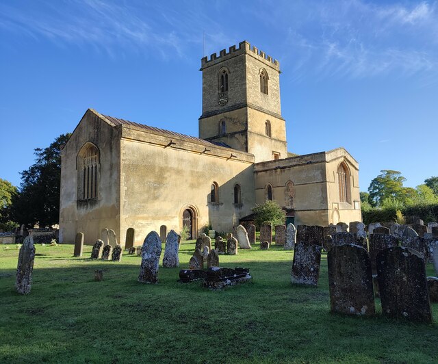
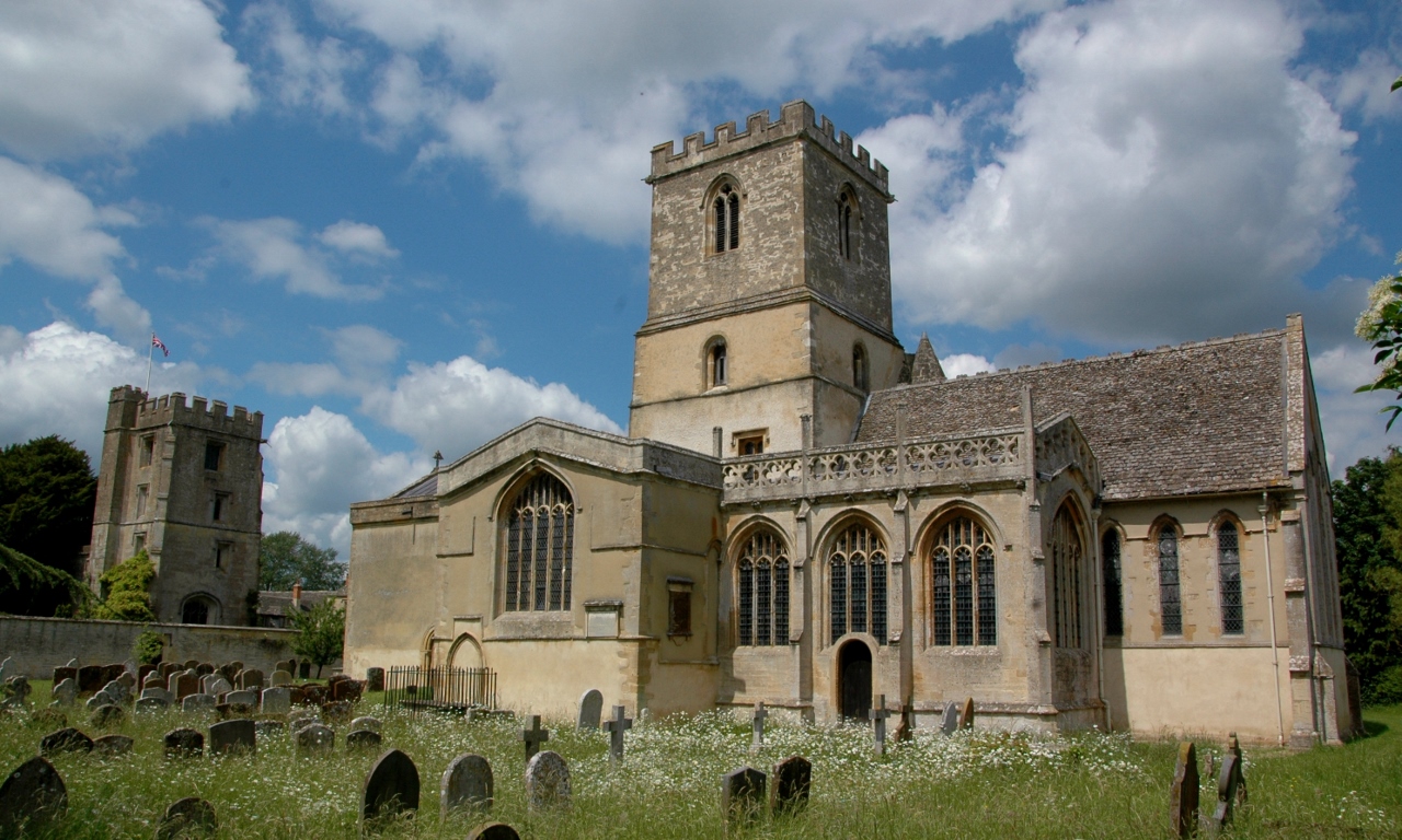
Chapel & Popes Tower is a historic heritage site located in Oxfordshire, England. This site is a unique architectural masterpiece that showcases the rich history and cultural significance of the region.

The Chapel & Popes Tower is primarily known for its stunning medieval architecture, which dates back to the 15th century. The tower, standing at an impressive height, offers panoramic views of the surrounding countryside and provides visitors with a truly breathtaking experience. The intricate stone carvings and detailed craftsmanship of the tower are a testament to the skill and artistry of the period.

The chapel, situated adjacent to the tower, is equally impressive. With its soaring ceilings and beautiful stained glass windows, it is considered a prime example of Gothic architecture. The chapel was once a place of worship and prayer, and its peaceful ambiance still resonates with visitors today.

Visitors to Chapel & Popes Tower can explore the site's rich history through informative displays and exhibits. These exhibits provide a fascinating insight into the tower's construction and the lives of the people who once inhabited it. Additionally, guided tours are available, allowing visitors to delve deeper into the site's history and learn about its significance in the local community.

Chapel & Popes Tower is a must-visit destination for history enthusiasts, architecture lovers, and anyone seeking a glimpse into Oxfordshire's rich cultural heritage. Its awe-inspiring beauty and historical importance make it a truly remarkable heritage site.

If you have any feedback on the listing, please let us know in the comments section below.

Chapel & Popes Tower Images

Images are sourced within 2km of 51.747/-1.398 or Grid Reference SP4105. Thanks to Geograph Open Source API. All images are credited.

St Michael's Church, Stanton Harcourt
S-bend on the lane to Stanton Harcourt A footpath to Blue Barn goes off to the left.
S-bend on the lane to Stanton Harcourt
A footpath to Blue Barn goes off to the left.
B4449 at Beard Mill Farm
The B4449 by Beard Mill Farm The B4449 runs from the A415 at Hardwick to Eynsham.
The B4449 by Beard Mill Farm
The B4449 runs from the A415 at Hardwick to Eynsham.
Footpath to South Leigh
Beard Mill On the icy-cold looking River Windrush, south-east of Witney.
This comment was supplied by a contributor in December 2009;
"This mill was nominated for the Downland Prize 2007. The Downland Prize has been awarded every year since 1998 to an architect based in RIBA South East or RIBA South regions, whose project with a total cost of £1 million, best demonstrates the benefits of using an architect’s services. The Downland Prize is sponsored by Ibstock Brick. The award for the best individual house is sponsored by the Management Recruitment Group; and the sustainability award, by the Rooflight Company."
Beard Mill
On the icy-cold looking River Windrush, south-east of Witney. This comment was supplied by a contributor in December 2009; "This mill was nominated for the Downland Prize 2007. The Downland Prize has been awarded every year since 1998 to an architect based in RIBA South East or RIBA South regions, whose project with a total cost of £1 million, best demonstrates the benefits of using an architect’s services. The Downland Prize is sponsored by Ibstock Brick. The award for the best individual house is sponsored by the Management Recruitment Group; and the sustainability award, by the Rooflight Company."
Footpath towards Tar Wood And South Leigh
Footpath towards Tar Wood
And South Leigh
Drive into Beard Mill
Footpath off the Cogges to Stanton Harcourt road
Cogges Lane, Blackditch
St. Michael's Church, Stanton Harcourt
The Harcourt Arms, Stanton Harcourt
Stanton Harcourt
Stanton Harcourt
footpath north of Bablock Hythe, Oxfordshire with sheep
footpath north of Bablock Hythe, Oxfordshire
with sheep
sheep may safely doze, footpath near Bablock Hythe
Bridleway through the woods To Northmoor about 1 mile.
Bridleway through the woods
To Northmoor about 1 mile.
Linch Hill Woods Opposite Linch Hill Cottages.
Linch Hill Woods
Opposite Linch Hill Cottages.
Footpath across the by-pass. The B4449 Stanton Harcourt by-pass, this gate leads across the fields to the village.
Footpath across the by-pass.
The B4449 Stanton Harcourt by-pass, this gate leads across the fields to the village.
Show me another place!

Chapel & Popes Tower is located at Grid Ref: SP4105 (Lat: 51.747, Lng: -1.398)

Administrative County: Oxfordshire

District: West Oxfordshire

Police Authority: Thames Valley

What 3 Words

///exam.rattled.offerings. Near Standlake, Oxfordshire

Related Wikis

Stanton Harcourt

Stanton Harcourt is a village and civil parish in Oxfordshire about 4 miles (6.4 km) southeast of Witney and about 6 miles (10 km) west of Oxford. The...

Devil's Quoits

The Devil's Quoits (grid reference SP411048) is a henge and stone circle to the south of the village of Stanton Harcourt in Oxfordshire, England. The site...

RAF Stanton Harcourt

Royal Air Force Stanton Harcourt or more simply RAF Stanton Harcourt is a former Royal Air Force satellite station located 4.4 miles (7.1 km) southeast...

Bablock Hythe

Bablock Hythe is a hamlet in Oxfordshire, England, some five miles (8 km) west of Oxford city centre. There was a ferry across the River Thames at Bablock...

Northmoor, Oxfordshire

Northmoor is a village and civil parish in West Oxfordshire, about 6 miles (10 km) west of Oxford and almost the same distance southeast of Witney. Northmoor...
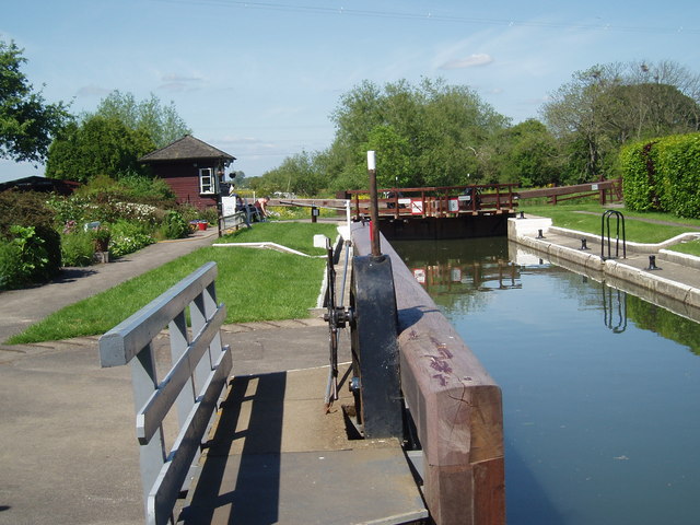
Pinkhill Lock

Pinkhill Lock is a lock on the River Thames in England. It is close to Farmoor, Oxfordshire. The first lock was built of stone by Daniel Harris for the...

Standlake

Standlake is a village and civil parish in West Oxfordshire about 5 miles (8 km) southeast of Witney and 7 miles (11 km) west of Oxford, England. The parish...

St Giles' Church, Standlake

The Parish Church of Saint Giles, Standlake is the Church of England parish church of Standlake, a village about 5 miles (8 km) southeast of Witney in...

Nearby Amenities

Located within 500m of 51.747,-1.398
Stanton Harcourt
Is In: Oxfordshire, England, UK
Place: village
Lat/Long: 51.7479629/-1.4039487
Bus Stop
Harcourt Arms
Bench: no
Bin: no
Bus: yes
Departures Board: no
Lit: no
Naptan AtcoCode: 340000704HA
Naptan Bearing: NW
Naptan CommonName: Harcourt Arms
Naptan Indicator: Outside
Naptan Landmark: Harcourt Arms
Naptan NaptanCode: oxfapaja
Naptan Street: Village Road
Naptan Verified: no
Public Transport: platform
Shelter: yes
Source: naptan_import
Tactile Paving: no
Wheelchair: yes
Lat/Long: 51.748857/-1.3997292
Bus Stop
Harcourt Arms
Bench: no
Bus: yes
Departures Board: no
Naptan AtcoCode: 340000704HAO
Naptan Bearing: SE
Naptan BusStopType: CUS
Naptan CommonName: Harcourt Arms
Naptan Indicator: Opposite
Naptan Landmark: Harcourt Arms
Naptan NaptanCode: oxfgajwm
Naptan Street: Village Road
Naptan Verified: no
Public Transport: platform
Shelter: no
Source: naptan_import
Lat/Long: 51.7492639/-1.4001729
Steadys Lane
Naptan AtcoCode: 340000704STC
Naptan Bearing: S
Naptan BusStopType: CUS
Naptan CommonName: Steadys Lane
Naptan Indicator: Corner
Naptan Landmark: Manor Farm
Naptan NaptanCode: oxfgajwj
Naptan Street: Village Road
Naptan Verified: no
Source: naptan_import
Lat/Long: 51.7469134/-1.3994508
Bus Stop
Steadys Lane
Bench: no
Bin: no
Bus: yes
Lit: no
Naptan AtcoCode: 340000704STO
Naptan Bearing: N
Naptan CommonName: Steadys Lane
Naptan Indicator: Opposite
Naptan Landmark: Manor Farm
Naptan NaptanCode: oxfgajwg
Naptan Street: Village Road
Naptan Verified: no
Public Transport: platform
Shelter: no
Source: naptan_import
Tactile Paving: no
Lat/Long: 51.7469501/-1.3995807
The Harcourt Stores
Opening Hours: "Closed indefinitely owing to staff shortage since mid-2022."
Shop: convenience
Website: https://www.theharcourtarms.com/the-stores
Wheelchair: yes
Lat/Long: 51.7488079/-1.3997987
Former RAF Stanton Harcourt
Abandoned Aeroway: aerodrome
Lat/Long: 51.7462103/-1.4014872
Entrance: main
Lat/Long: 51.748064/-1.397966
Post Box
Brand: Royal Mail
Brand Wikidata: Q638098
Collection Times: Mo-Fr 09:00; Sa 07:00
Operator: Royal Mail
Operator Wikidata: Q638098
Post Box Type: pillar
Ref: OX29 53D
Royal Cypher: GR
Royal Cypher Wikidata: Q33102273
Lat/Long: 51.7493389/-1.4015261
Material: wood
Power: pole
Lat/Long: 51.7485591/-1.4047041
Material: wood
Power: pole
Lat/Long: 51.7482027/-1.4044916
Material: wood
Power: pole
Lat/Long: 51.7480197/-1.4050604
Bench
Backrest: yes
Material: wood
Lat/Long: 51.7495248/-1.4040151
Waste Basket
Waste: trash;dog_excrement
Lat/Long: 51.7495055/-1.4040116
Man Made: utility_pole
Material: wood
Utility: telecom
Lat/Long: 51.7494711/-1.4040684
Access: private
Capacity: 15
Leisure: outdoor_seating
Lit: no
Lat/Long: 51.7498561/-1.400169
Artwork Type: mosaic
Tourism: artwork
Lat/Long: 51.7498016/-1.4000515
Bench
Backrest: yes
Material: wood
Seats: 3
Lat/Long: 51.7489906/-1.4018018
Bench
Backrest: yes
Material: wood
Seats: 3
Lat/Long: 51.7489983/-1.401921
Parking Space
Capacity: 1
Lat/Long: 51.7451916/-1.3987603
Parking Space
Capacity: 2
Lat/Long: 51.7452204/-1.3989371
Historic: memorial
Inscription: The former RAF Stanton Harcourt We remember all those who fought for our freedom in WW2 They did not die in vain [list of names] Kindly donated in 2020 by Hayfield: developer of this site
Material: metal
Memorial: plaque
Start Date: 2020
Lat/Long: 51.7457276/-1.3999393
Entrance: yes
Lat/Long: 51.7483049/-1.3985034
Waste Basket
Waste: trash;dog_excrement
Lat/Long: 51.7512392/-1.3987615
Waste Basket
Waste: trash;dog_excrement
Lat/Long: 51.7498835/-1.4005079
Crossing
Crossing: unmarked
Crossing Island: no
Tactile Paving: yes
Lat/Long: 51.7492138/-1.4019128
The data included in this document is from www.openstreetmap.org. The data is made available under ODbL.

Have you been to Chapel & Popes Tower?

Leave your review of Chapel & Popes Tower below (or comments, questions and feedback).