Castle of Fiddes
Heritage Site in Kincardineshire
Scotland
Castle of Fiddes

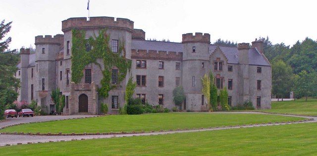
The Castle of Fiddes, located in Kincardineshire, Scotland, is a historic heritage site that dates back to the 16th century. Situated on a picturesque hilltop, the castle offers breathtaking views of the surrounding countryside.
Originally built as a fortified tower house, the castle has undergone several modifications and additions over the centuries. The architecture of the castle reflects a mix of medieval and Renaissance styles, with its sturdy stone walls, narrow windows, and imposing battlements.
The Castle of Fiddes played a significant role in the region's history. It served as a defensive stronghold for local clans during times of conflict and as a residence for various noble families. The castle's strategic location allowed its occupants to have a commanding position over the surrounding lands, providing protection and control over the area.
Today, the castle is open to the public as a heritage site, offering visitors a glimpse into the past. Exploring the castle's well-preserved interiors, visitors can admire the grandeur of its architecture and learn about the history of the surrounding area. The castle also hosts various events and exhibitions, showcasing the rich cultural heritage of Kincardineshire.
Whether it is the stunning views from its ramparts or the captivating stories of its past, the Castle of Fiddes continues to enchant visitors and serves as a testament to the region's history and architectural heritage.
If you have any feedback on the listing, please let us know in the comments section below.
Castle of Fiddes Images
Images are sourced within 2km of 56.925/-2.287 or Grid Reference NO8281. Thanks to Geograph Open Source API. All images are credited.


Castle of Fiddes is located at Grid Ref: NO8281 (Lat: 56.925, Lng: -2.287)
What 3 Words
///toggle.stung.graduated. Near Stonehaven, Aberdeenshire
Nearby Locations
Related Wikis

Castle of Fiddes
The Castle of Fiddes is a 16th-century tower house in Aberdeenshire, Scotland, located around 6 kilometres (3.7 mi) south-west of Stonehaven. It is dated...

Tewel
Tewel is a hamlet located approximately two miles west of Stonehaven, Kincardineshire on the Auchenblae Road in Northeast Scotland. It consists of: Tewel...
Drumlithie railway station
Drumlithie railway station served the village of Drumlithie, Aberdeenshire, Scotland from 1849 to 1956 on the Aberdeen Railway. == History == The station...
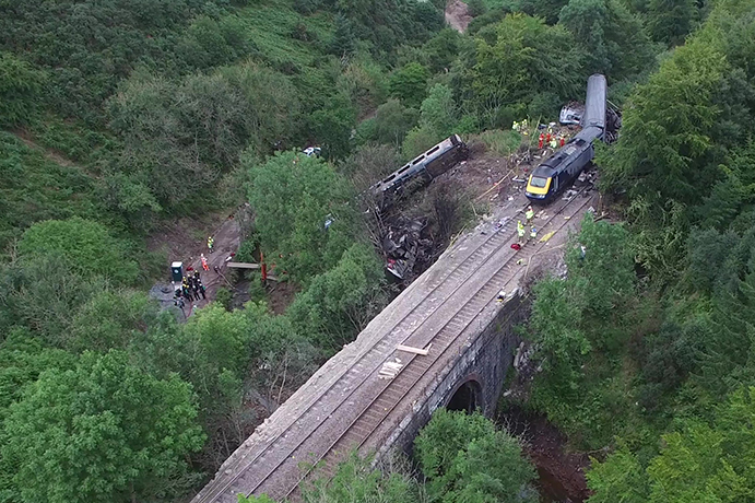
Stonehaven derailment
The Stonehaven derailment was a fatal railway accident that occurred at 09:38 BST on 12 August 2020, when a passenger train returning to Aberdeen hit a...

Drumlithie
Drumlithie is a village in the Howe of the Mearns in southern Aberdeenshire, Scotland. Situated seven miles south of Stonehaven in the parish of Glenbervie...

Carmont railway station
Carmont railway station, on the Aberdeen Railway, served the rural area of Carmont in Aberdeenshire, Scotland from 1855 to 1964. == History == The station...
Fetteresso Castle
Fetteresso Castle is a 14th-century tower house, rebuilt in 1761 as a Scottish Gothic style Palladian manor, with clear evidence of prehistoric use of...

Kirktown of Fetteresso
The Kirktown of Fetteresso is a well-preserved village near Stonehaven, Scotland. In the planning area of Kincardine and Mearns, Aberdeenshire, this village...
Nearby Amenities
Located within 500m of 56.925,-2.287Have you been to Castle of Fiddes?
Leave your review of Castle of Fiddes below (or comments, questions and feedback).