Castle Cary

Heritage Site in Stirlingshire

Scotland

Castle Cary

Allandale Cottages The northern side of a neat row of workers' cottages on the B816 - here there are 46 in four blocks. They were built in 1907 by John G Stein to house workers from his nearby Castlecary Fireclay Works <a href="https://www.geograph.org.uk/gridref/NS+7978">NS 7978</a>. They were named after his son, Allan. Built from red sandstone, with pitched slate roofs, the S row cottages are similar, but without the dormer windows. For a closer view see <a href="https://www.geograph.org.uk/photo/6194373">NS8078 : Allandale Cottages</a>. <span class="nowrap"><a title="https://canmore.org.uk/site/150976/castlecary-allandale-cottages" rel="nofollow ugc noopener" href="https://canmore.org.uk/site/150976/castlecary-allandale-cottages">Link</a><img style="margin-left:2px;" alt="External link" title="External link - shift click to open in new window" src="https://s1.geograph.org.uk/img/external.png" width="10" height="10"/></span>. The '5 mph Play Street 8am to sunset except for access' refers to the road at the back of the cottages <a href="https://www.geograph.org.uk/photo/6194381">NS8078 : Allandale Cottages - Play Street</a>, not the one in view!
Allandale Cottages Credit: M J Richardson

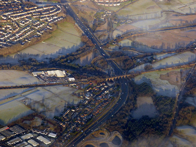
Castle Cary, located in Stirlingshire, Scotland, is a historically significant heritage site that dates back to the medieval period. Situated on a prominent hill overlooking the River Forth, the castle has played a crucial role in the region's history and has witnessed numerous significant events.

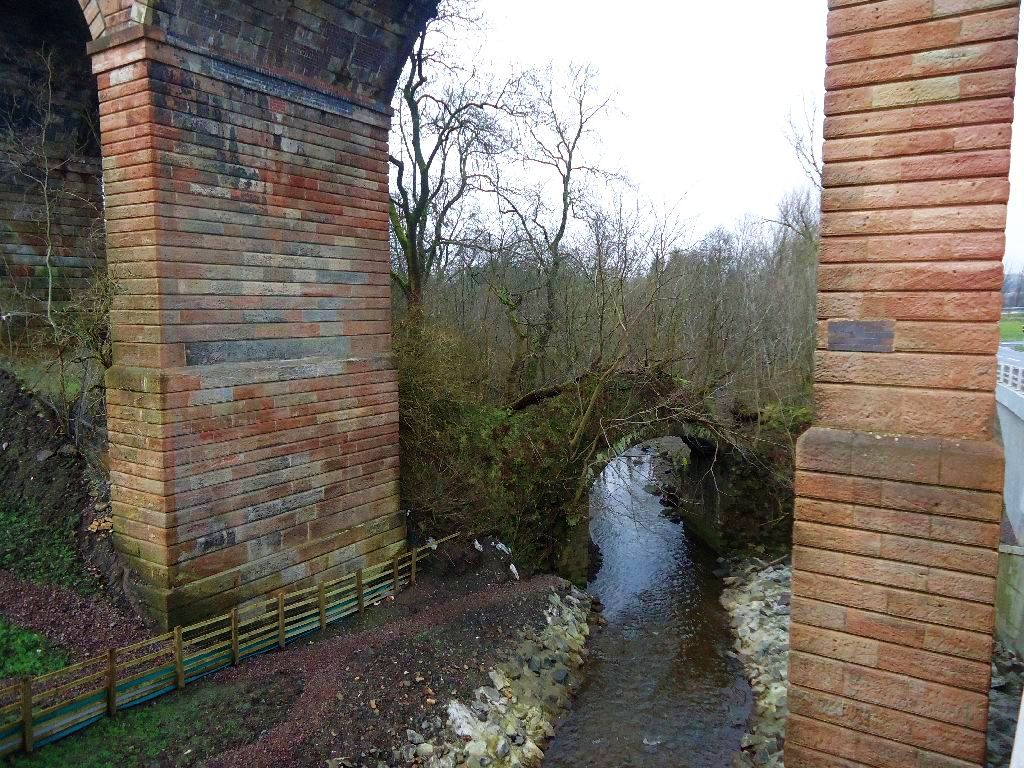
Built in the 12th century, Castle Cary was initially a stronghold of the powerful Stewart family. Over the centuries, it passed through the hands of several noble families, each leaving their mark on the castle's architecture and layout. The castle's distinctive features include a tall tower, defensive walls, and a well-preserved courtyard.

Throughout its existence, Castle Cary has been involved in several important historical episodes. During the Wars of Scottish Independence, it served as a key strategic point and was besieged multiple times. The castle witnessed the arrival of Mary, Queen of Scots, in 1567, and later became the site of a skirmish between Royalists and Covenanters during the Civil War.

Today, Castle Cary stands as a testament to the region's rich history and architectural heritage. Visitors can explore the castle's ruins, taking in its impressive structure and enjoying panoramic views of the surrounding landscape. Interpretive signage provides information on the castle's history, and guided tours are available to offer a deeper understanding of its significance.

Castle Cary's location, perched atop a hill with commanding views, makes it a popular destination for history enthusiasts and those seeking to soak in the region's natural beauty. Its historical importance, combined with its picturesque setting, ensures that Castle Cary remains a cherished heritage site in Stirlingshire.

If you have any feedback on the listing, please let us know in the comments section below.

Castle Cary Images

Images are sourced within 2km of 55.9757/-3.9453 or Grid Reference NS7877. Thanks to Geograph Open Source API. All images are credited.

Allandale Cottages The northern side of a neat row of workers' cottages on the B816 - here there are 46 in four blocks. They were built in 1907 by John G Stein to house workers from his nearby Castlecary Fireclay Works <a href="https://www.geograph.org.uk/gridref/NS+7978">NS 7978</a>. They were named after his son, Allan. Built from red sandstone, with pitched slate roofs, the S row cottages are similar, but without the dormer windows. For a closer view see <a href="https://www.geograph.org.uk/photo/6194373">NS8078 : Allandale Cottages</a>. <span class="nowrap"><a title="https://canmore.org.uk/site/150976/castlecary-allandale-cottages" rel="nofollow ugc noopener" href="https://canmore.org.uk/site/150976/castlecary-allandale-cottages">Link</a><img style="margin-left:2px;" alt="External link" title="External link - shift click to open in new window" src="https://s1.geograph.org.uk/img/external.png" width="10" height="10"/></span>. The '5 mph Play Street 8am to sunset except for access' refers to the road at the back of the cottages <a href="https://www.geograph.org.uk/photo/6194381">NS8078 : Allandale Cottages - Play Street</a>, not the one in view!
Allandale Cottages
The northern side of a neat row of workers' cottages on the B816 - here there are 46 in four blocks. They were built in 1907 by John G Stein to house workers from his nearby Castlecary Fireclay Works NS 7978. They were named after his son, Allan. Built from red sandstone, with pitched slate roofs, the S row cottages are similar, but without the dormer windows. For a closer view see NS8078 : Allandale Cottages. LinkExternal link. The '5 mph Play Street 8am to sunset except for access' refers to the road at the back of the cottages NS8078 : Allandale Cottages - Play Street, not the one in view!
Allandale Cottages The northern side of a neat row of workers' cottages on the B816 - here there are 46 in four blocks. They were built in 1907 by John G Stein to house workers from his nearby Castlecary Fireclay Works <a href="https://www.geograph.org.uk/gridref/NS+7978">NS 7978</a>. They were named after his son, Allan. Built from red sandstone, with pitched slate roofs, the S row cottages are similar, but without the dormer windows. <span class="nowrap"><a title="https://canmore.org.uk/site/150976/castlecary-allandale-cottages" rel="nofollow ugc noopener" href="https://canmore.org.uk/site/150976/castlecary-allandale-cottages">Link</a><img style="margin-left:2px;" alt="External link" title="External link - shift click to open in new window" src="https://s1.geograph.org.uk/img/external.png" width="10" height="10"/></span>. For a longer view see <a href="https://www.geograph.org.uk/photo/6194370">NS8078 : Allandale Cottages</a>.
Allandale Cottages
The northern side of a neat row of workers' cottages on the B816 - here there are 46 in four blocks. They were built in 1907 by John G Stein to house workers from his nearby Castlecary Fireclay Works NS 7978. They were named after his son, Allan. Built from red sandstone, with pitched slate roofs, the S row cottages are similar, but without the dormer windows. LinkExternal link. For a longer view see NS8078 : Allandale Cottages.
Allandale Cottages - Play Street The rear of the cottages pictured in <a href="https://www.geograph.org.uk/photo/6194373">NS8078 : Allandale Cottages</a>. Parking spaces alternate with lawns and drying greens, and the strip coincides with the course of the Antonine Wall; immediately to the left of the trees is the Forth & Clyde Canal.
Allandale Cottages - Play Street
The rear of the cottages pictured in NS8078 : Allandale Cottages. Parking spaces alternate with lawns and drying greens, and the strip coincides with the course of the Antonine Wall; immediately to the left of the trees is the Forth & Clyde Canal.
B816: Allandale Allandale Cottage built for workers at John G. Stein brickworks
B816: Allandale
Allandale Cottage built for workers at John G. Stein brickworks
Cruising the canal Heading west between locks 17 & 18
Cruising the canal
Heading west between locks 17 & 18
Castlecary Viaduct from the A80
Cumbernauld, Walton Burn Flowing through a gully next to Abronhill's ring road a fairly wide burn. Note the ochre seeping from the sandstone.
Cumbernauld, Walton Burn
Flowing through a gully next to Abronhill's ring road a fairly wide burn. Note the ochre seeping from the sandstone.
Castlecary, Millennium Bridge Carries the Glasgow to Stirling road A/M80 over the Forth & Clyde Canal.
Castlecary, Millennium Bridge
Carries the Glasgow to Stirling road A/M80 over the Forth & Clyde Canal.
Forth & Clyde Canal, Castlecary bridge This new bridge (built 2000) replaced a swing bridge which carried the old Glasgow to Stirling trunk road prior to the building of the A80 dual carriageway nearby. See RCAHMS record <span class="nowrap"><a title="http://canmore.rcahms.gov.uk/en/site/90344/details/castlecary+swing+bridge+forth+and+clyde+canal/" rel="nofollow ugc noopener" href="http://canmore.rcahms.gov.uk/en/site/90344/details/castlecary+swing+bridge+forth+and+clyde+canal/">Link</a><img style="margin-left:2px;" alt="External link" title="External link - shift click to open in new window" src="https://s1.geograph.org.uk/img/external.png" width="10" height="10"/></span>
Forth & Clyde Canal, Castlecary bridge
This new bridge (built 2000) replaced a swing bridge which carried the old Glasgow to Stirling trunk road prior to the building of the A80 dual carriageway nearby. See RCAHMS record LinkExternal link
Castlecary, farm track Runs along the southern side of the Forth & Clyde Canal.
Castlecary, farm track
Runs along the southern side of the Forth & Clyde Canal.
Forth & Clyde Canal, ruins Adjacent to lock 19 these maybe the foundations of a lock keeper's dwelling.
Forth & Clyde Canal, ruins
Adjacent to lock 19 these maybe the foundations of a lock keeper's dwelling.
Forth & Clyde Canal, lock 19
Forth & Clyde Canal, lock 19 Looking westward. Like other locks on this canal this one doubles as a weir draining excess water from the summit level.
Forth & Clyde Canal, lock 19
Looking westward. Like other locks on this canal this one doubles as a weir draining excess water from the summit level.
Forth & Clyde Canal, lock 19 Looking eastward.
Forth & Clyde Canal, lock 19
Looking eastward.
Castlecary bridge View from the east. See also <a href="https://www.geograph.org.uk/photo/2350935">NS7878 : Forth & Clyde Canal, Castlecary bridge</a>
Castlecary bridge
Castlecary, land engineering works Excavation of drainage channel and suds ponds to take surface water from the adjacent motorway under construction. After filtering through two ponds it will be channelled into the Bonny Water. Let's hope it works.
Castlecary, land engineering works
Excavation of drainage channel and suds ponds to take surface water from the adjacent motorway under construction. After filtering through two ponds it will be channelled into the Bonny Water. Let's hope it works.
Castlecary, Millennium bridge As the Forth & Clyde canal passes under.
Castlecary, Millennium bridge
As the Forth & Clyde canal passes under.
Woodneuk aqueduct and Red Burn Everything you see in this photo is man made - including the river. 

The aqueduct, built in 1770 carries the Forth & Clyde canal. The canal Resident Engineer, Robert Mackell, under pressure to trim costs diverted the Red Burn from its natural route which went north-west to join the Bonny Water to a directly northern course to enable a shorter span for the aqueduct over the river.
Woodneuk aqueduct and Red Burn
Everything you see in this photo is man made - including the river. The aqueduct, built in 1770 carries the Forth & Clyde canal. The canal Resident Engineer, Robert Mackell, under pressure to trim costs diverted the Red Burn from its natural route which went north-west to join the Bonny Water to a directly northern course to enable a shorter span for the aqueduct over the river.
Show me another place!

Castle Cary is located at Grid Ref: NS7877 (Lat: 55.9757, Lng: -3.9453)

Unitary Authority: Falkirk

Police Authority: Forth Valley

What 3 Words

///coupler.procured.dares. Near Banknock, Falkirk

Related Wikis

Castle Cary Castle

Castle Cary Castle (sometimes called Castlecary Castle) is a fifteenth-century tower house, about 6 miles (10 km) from Falkirk, in the former county...

Castlecary

Castlecary () is a small historic village in North Lanarkshire, Scotland, directly adjacent to the border with Falkirk. It has long been associated with...

Castlecary rail accidents

Two rail accidents have occurred near Castlecary, Scotland. One of these was in 1937 and one in 1968. Both events involved rear-end collisions, and caused...

Castlecary railway station

Castlecary railway station served the village of Castlecary, North Lanarkshire, Scotland from 1842 to 1967 on the Edinburgh and Glasgow Railway. ��2�...

Red Burn

The Red Burn is one of two main streams which flow out of Cumbernauld. The Scottish New Town’s name derives from the Gaelic for "the meeting of the waters...

Wardpark

Wardpark is an industrial estate in Cumbernauld, Scotland split by the M80 motorway. The former Burroughs factory, the first factory of Cumbernauld new...

Banknock

Banknock (Scottish Gaelic: Baile nan Cnoc) is a village within the Falkirk council area in Central Scotland. The village is 6.7 miles (10.8 km) west-southwest...

Abronhill

Abronhill () is an area in the north-east of Cumbernauld, North Lanarkshire, Scotland. It extends one to two miles (two to three kilometres) from Cumbernauld...

Nearby Amenities

Located within 500m of 55.9757,-3.9453
Material: wood
Power: pole
Lat/Long: 55.9792805/-3.940672
Material: wood
Power: pole
Lat/Long: 55.9794609/-3.9444237
Material: wood
Power: pole
Lat/Long: 55.9796662/-3.942815
Castlecary
Place: village
Wikidata: Q5050472
Wikipedia: en:Castlecary
Lat/Long: 55.9794877/-3.9473796
Power: pole
Lat/Long: 55.9751211/-3.94425
Power: pole
Lat/Long: 55.9745651/-3.9439583
Power: pole
Lat/Long: 55.9740254/-3.9428396
Power: pole
Lat/Long: 55.9736978/-3.9421209
Power: pole
Lat/Long: 55.9730613/-3.9406585
Power: pole
Lat/Long: 55.9727151/-3.9397899
Bus Stop
Wardpark, Castlecary Road before Tollpark Road
Bus: yes
Departures Board: timetable
Naptan AtcoCode: 61601344
Naptan NaptanCode: 65236397
Public Transport: platform
Shelter: no
Lat/Long: 55.9762735/-3.9526439
Bus Stop
Wardpark, Castlecary Road opp Tollpark Road
Bus: yes
Departures Board: timetable
Naptan AtcoCode: 61601345
Naptan NaptanCode: 65237254
Public Transport: platform
Shelter: no
Lat/Long: 55.9757279/-3.9530948
Bus Stop
Castlecary, Castlecary Road opp Garnhill Farm Road
Bus: yes
Departures Board: timetable
Naptan AtcoCode: 61601343
Naptan NaptanCode: 65235353
Public Transport: platform
Shelter: no
Lat/Long: 55.977458/-3.9506658
Bus Stop
Castlecary, Castlecary Road opp Castle Court
Bus: yes
Departures Board: timetable
Naptan AtcoCode: 61601342
Naptan NaptanCode: 65232329
Public Transport: platform
Shelter: yes
Lat/Long: 55.9783638/-3.9495704
Bus Stop
Castlecary, Castlecary Road opp Castlecary House Hotel
Bus: yes
Departures Board: timetable
Naptan AtcoCode: 61601341
Naptan NaptanCode: 65236849
Public Transport: platform
Shelter: no
Lat/Long: 55.9798059/-3.9471958
Bus Stop
Castlecary, Castlecary Road at Castlecary House Hotel
Bus: yes
Departures Board: timetable
Naptan AtcoCode: 61601340
Naptan NaptanCode: 65235934
Public Transport: platform
Shelter: no
Lat/Long: 55.9799995/-3.9470231
Post Box
Collection Plate: CP7D
Collection Plate Date: 2022-09-21
Collection Times: Mo-Fr 09:00; Sa 07:00
Operator: Royal Mail
Post Box Design: LB3426
Post Box Mounting: pier
Post Box Type: lamp
Ref: G68 11D
Royal Cypher: scottish_crown
Source: survey
Lat/Long: 55.978719/-3.9493659
The data included in this document is from www.openstreetmap.org. The data is made available under ODbL.

Have you been to Castle Cary?

Leave your review of Castle Cary below (or comments, questions and feedback).