Carnfachbugeilyn

Heritage Site in Cardiganshire

Wales

Carnfachbugeilyn

Boundary marker stone and small cairn Above Hafren Forest.
Boundary marker stone and small cairn Credit: John Lucas

Carnfachbugeilyn is a historic heritage site located in Cardiganshire, Wales. Situated in the scenic countryside, this site holds great cultural and historical significance.

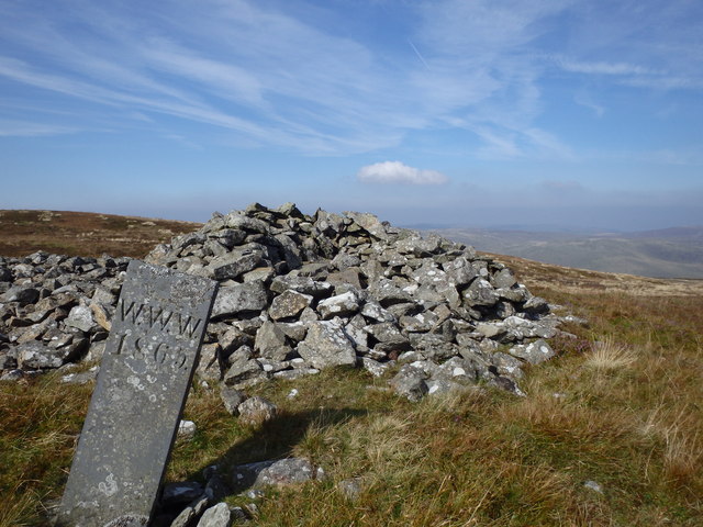
The main feature of Carnfachbugeilyn is a Neolithic burial chamber, dating back to around 3500-2000 BC. This chamber, also known as a chambered tomb, consists of a large capstone supported by several upright stones, creating a fascinating and iconic structure. Archaeological excavations have revealed that this tomb was used for communal burials during the Neolithic period.

Surrounding the burial chamber, there are traces of ancient settlement remains and evidence of agricultural activity, indicating that this site was not only used for burial purposes but also served as a place for human habitation.

Carnfachbugeilyn is a protected heritage site, recognized for its historical and archaeological importance. It offers visitors a unique opportunity to explore and learn about the lives of our ancestors from thousands of years ago. The site provides information boards and interpretation panels, helping visitors understand the significance and context of the chambered tomb and the history of the surrounding area.

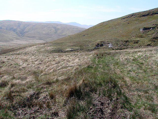
The natural beauty of the Cardiganshire countryside adds to the charm of Carnfachbugeilyn. Surrounded by rolling hills and lush greenery, this site offers a peaceful and serene atmosphere for visitors to enjoy. It is a popular destination for history enthusiasts, archaeology students, and anyone interested in exploring the ancient heritage of Wales.

If you have any feedback on the listing, please let us know in the comments section below.

Carnfachbugeilyn Images

Images are sourced within 2km of 52.5/-3.732 or Grid Reference SN8290. Thanks to Geograph Open Source API. All images are credited.

Boundary marker stone and small cairn Above Hafren Forest.
Boundary marker stone and small cairn
Above Hafren Forest.
Carreg derfyn a charn fach / A boundary stone and small cairn Carreg derfyn a charn fach yn dynodi ffin Ceredigion a Phowys. Y fan yn y pellter yw Pumlumon Arwystli.

A boundary stone and small cairn denoting the boundary between Ceredigion and Powys. The peak in the distance is Pumlumon Arwystli.
Carreg derfyn a charn fach / A boundary stone and small cairn
Carreg derfyn a charn fach yn dynodi ffin Ceredigion a Phowys. Y fan yn y pellter yw Pumlumon Arwystli. A boundary stone and small cairn denoting the boundary between Ceredigion and Powys. The peak in the distance is Pumlumon Arwystli.
On Bryn Cras
On Bryn Cras
Pombren ar Ffordd Hafren / A footbridge on the Severn Way Pompren fach ar Ffordd Hafren.

A small footbridge on the Severn Way.
Pombren ar Ffordd Hafren / A footbridge on the Severn Way
Pompren fach ar Ffordd Hafren. A small footbridge on the Severn Way.
Ffordd Hafren / The Severn Way Cerddwyr yn dilyn Ffordd Hafren.

Walkers following the Severn Way.
Ffordd Hafren / The Severn Way
Cerddwyr yn dilyn Ffordd Hafren. Walkers following the Severn Way.
Llwybr Hafren / The Severn Way Llwybr Hafren yn mynd tuag at y blanhigfa goniferaidd, y mae llawer ohoni yn y pellter wedi'i dymchwel.

The Severn Way heading towards the conifer Plantation, much of it in the distance has been felled.
Llwybr Hafren / The Severn Way
Llwybr Hafren yn mynd tuag at y blanhigfa goniferaidd, y mae llawer ohoni yn y pellter wedi'i dymchwel. The Severn Way heading towards the conifer Plantation, much of it in the distance has been felled.
Blaen Hafren / Source of the Severn River Yn y pellter mae postyn yn nodi'n fras lleoliad blaen Hafren.

The post in the distance marks the approximate location of the source of the Severn River.
Blaen Hafren / Source of the Severn River
Yn y pellter mae postyn yn nodi'n fras lleoliad blaen Hafren. The post in the distance marks the approximate location of the source of the Severn River.
Llwybr ger Blaen Hafren / Path near source of the Severn Llwybr yn dilyn ffens ger Blaen Hafren. 

A path following a fence near the source of the Severn.
Llwybr ger Blaen Hafren / Path near source of the Severn
Llwybr yn dilyn ffens ger Blaen Hafren. A path following a fence near the source of the Severn.
Llyn dienw  ar Fryn Cras / Unnamed lake on Bryn Cras Llyn dienw ar Fryn Cras. Ar y llyn y mae dau wydd Canadaidd. 


An unnamed lake on Bryn Cras (trans. scorched hill). On the lake are two Canadian geese.
Llyn dienw ar Fryn Cras / Unnamed lake on Bryn Cras
Llyn dienw ar Fryn Cras. Ar y llyn y mae dau wydd Canadaidd. An unnamed lake on Bryn Cras (trans. scorched hill). On the lake are two Canadian geese.
Stone marker on the county boundary The WWW refers to Sir Watkin Williams-Wynn, a Baronet and major landowner in Victorian Wales who had this and presemably many other boundary markers erected in 1865 along the boundary of his vast estates. Some great old graffiti too.
Stone marker on the county boundary
The WWW refers to Sir Watkin Williams-Wynn, a Baronet and major landowner in Victorian Wales who had this and presemably many other boundary markers erected in 1865 along the boundary of his vast estates. Some great old graffiti too.
Looking towards Foel Uchaf The footpath here (such as it is) is well above the valley floor because of the boggy ground that is found beside the river. Even at this height, wet feet and 'that sinking feeling' are a hazard for the unwary!
Looking towards Foel Uchaf
The footpath here (such as it is) is well above the valley floor because of the boggy ground that is found beside the river. Even at this height, wet feet and 'that sinking feeling' are a hazard for the unwary!
Where does the path go? The map has the right of way passing over the top of this hill (which seems to have escaped being named). In practice, most people appear to skirt the base of the hill to the right to join the water board track which ends at <a href="https://www.geograph.org.uk/gridref/SN81899162">SN81899162</a>.

My thanks to David Williams for the following tale:

The path goes from Dylife to Cardiganshire! My father, William David Williams, took this very path with a farm-horse named "Bess", starting before dawn on 25th December 1938 from Gwartew, Staylittle and arrived at Llawrcwm-bach in the upper valley of the River Leri at lunchtime. He had lunch with his sister Margaretta Evans, her husband and family. He then started his return journey to Staylittle with his nephew, Gareth Evans (now a retired pensioner living at Swn-y-Ffrwd, Bontgoch) sitting on horseback. They passed the farmers at Nant-y-moch feeding some sheep with hay and by the time they reached the Pumlimon water-shed, it was dark. My father had to dismount and check that they were on the correct side of a cairn of stones (to avoid taking them between some water-filled peat trenches). Half an hour later the moon had risen and they arrived home safely in Gwartew, to be greeted by my mother the same day! A wonderful, true account of life in Wales, bringing Christmas Greetings to a little boy!

Afternote: Gwartew is at grid ref <a href="https://www.geograph.org.uk/gridref/SN89899194">SN89899194</a> and Llawrcwm-bach is at grid ref <a href="https://www.geograph.org.uk/gridref/SN70818538">SN70818538</a>
Where does the path go?
The map has the right of way passing over the top of this hill (which seems to have escaped being named). In practice, most people appear to skirt the base of the hill to the right to join the water board track which ends at SN81899162. My thanks to David Williams for the following tale: The path goes from Dylife to Cardiganshire! My father, William David Williams, took this very path with a farm-horse named "Bess", starting before dawn on 25th December 1938 from Gwartew, Staylittle and arrived at Llawrcwm-bach in the upper valley of the River Leri at lunchtime. He had lunch with his sister Margaretta Evans, her husband and family. He then started his return journey to Staylittle with his nephew, Gareth Evans (now a retired pensioner living at Swn-y-Ffrwd, Bontgoch) sitting on horseback. They passed the farmers at Nant-y-moch feeding some sheep with hay and by the time they reached the Pumlimon water-shed, it was dark. My father had to dismount and check that they were on the correct side of a cairn of stones (to avoid taking them between some water-filled peat trenches). Half an hour later the moon had risen and they arrived home safely in Gwartew, to be greeted by my mother the same day! A wonderful, true account of life in Wales, bringing Christmas Greetings to a little boy! Afternote: Gwartew is at grid ref SN89899194 and Llawrcwm-bach is at grid ref SN70818538
End of the water board track in the upper Hengwm Valley
The southern extent of Bugeilyn The forestry on the hill in the distance sits on the northern face of Cefn Llwyd at Bryn yr wyn.
The southern extent of Bugeilyn
The forestry on the hill in the distance sits on the northern face of Cefn Llwyd at Bryn yr wyn.
The summit of Carn Fawr My GPS is on the nearby pillar because I contribute to a database which records positions at known 'highest points'. I did know where I was!
The summit of Carn Fawr
My GPS is on the nearby pillar because I contribute to a database which records positions at known 'highest points'. I did know where I was!
Near the source of the River Severn Looking towards Carnfachbugeilyn. A landscape of boggy peathags.
Near the source of the River Severn
Looking towards Carnfachbugeilyn. A landscape of boggy peathags.
Carnfachbugeilyn Ancient cairn near the source of the Severn.
Carnfachbugeilyn
Ancient cairn near the source of the Severn.
Descending Carnfachbugeilyn Rough moorland but fairly easy if you stick to the fence line. In the far distance is Bugeilyn the small lake after which Carnfachbugeilyn and Banc Bugeilyn appear to be named.
Descending Carnfachbugeilyn
Rough moorland but fairly easy if you stick to the fence line. In the far distance is Bugeilyn the small lake after which Carnfachbugeilyn and Banc Bugeilyn appear to be named.
Show me another place!

Carnfachbugeilyn is located at Grid Ref: SN8290 (Lat: 52.5, Lng: -3.732)

Unitary Authority: Ceredigion

Police Authority: Dyfed Powys

What 3 Words

///headset.eggshell.hops. Near Staylittle, Powys

Related Wikis

Pumlumon Cwmbiga

Pumlumon Cwmbiga is a summit of the Pumlumon mountain range in Ceredigion, Wales. It is 620 metres (2,034) feet above sea level and is a deleted Nuttall...

Banc Bugeilyn

Banc Bugeilyn is a hill found in Plynlimon between Aberystwyth and Welshpool in the United Kingdom; grid reference SN826925.The summit is class as a Dewey...

Bryn yr Ŵyn

Bryn yr Ŵyn (Welsh for 'hill of the lambs') is a former Dewey in the foothills of Plynlimon between Aberystwyth and Welshpool in Wales. The summit height...

Pen Pumlumon Arwystli

Pen Pumlumon Arwystli is the second highest summit on the Plynlimon massif, a part of the Cambrian Mountains in the county of Ceredigion, Wales. The summit...

Nearby Amenities

Located within 500m of 52.5,-3.732
Historic: boundary_stone
Source: Bing
Lat/Long: 52.4986394/-3.7303415
Carnfachbugeilyn
Place: hamlet
Lat/Long: 52.4983443/-3.7350258
Carn Brydain-uchaf
Place: hamlet
Lat/Long: 52.4992978/-3.7274513
The data included in this document is from www.openstreetmap.org. The data is made available under ODbL.

Have you been to Carnfachbugeilyn?

Leave your review of Carnfachbugeilyn below (or comments, questions and feedback).