Becket's Barn

Heritage Site in Sussex Arun

England

Becket's Barn

St. Thomas a'Becket, Pagham
St. Thomas a'Becket, Pagham Credit: Jeff Gogarty

Becket's Barn is a historic heritage site located in Sussex, England. Situated in the picturesque countryside, this barn holds significant historical and architectural value.

The barn dates back to the 13th century and is believed to have been part of the nearby Battle Abbey Estate. It is named after Thomas Becket, the Archbishop of Canterbury, who was martyred in 1170. While there is no concrete evidence linking Becket to the barn, local folklore suggests that it may have been used to house his horses during his stay in the area.

The barn is a fine example of medieval architecture, characterized by its timber-framed structure and thatched roof. It features a large central hall with impressive oak beams and a stone floor, showcasing the craftsmanship of the era. Over the centuries, the barn has undergone various modifications and repairs, including the addition of brick walls in the 17th century.

Today, Becket's Barn serves as a popular venue for weddings, events, and exhibitions. Its rustic charm and unique atmosphere make it an ideal setting for a variety of occasions. Visitors can also explore the surrounding grounds, which offer stunning views of the Sussex countryside.

As a heritage site, Becket's Barn is protected by preservation laws, ensuring its historical significance is maintained for future generations to appreciate. It stands as a testament to the rich history and architectural heritage of Sussex, attracting both locals and tourists alike.

If you have any feedback on the listing, please let us know in the comments section below.

Becket's Barn Images

Images are sourced within 2km of 50.77/-0.745 or Grid Reference SZ8897. Thanks to Geograph Open Source API. All images are credited.

St. Thomas a'Becket, Pagham
Interior St. Thomas a'Becket, Pagham
Down church path to a thatched cottage
Footpath to Honer Farm from Halsey's Farm
Coarse grass near Pagham Harbour Pagham Harbour is a natural harbour in West Sussex. It is south of the city of Chichester and near the towns of Pagham and Selsey.
Whether it is a bay or estuary is a debateable point.
It is a biological Site of Special Scientific Interest, a Local Nature Reserve, a Special Protection Area, and a Ramsar site. Its shingle spit is further designated a Geological Conservation Review site. In spring or autumn rare migratory birds can often be seen. Pagham Harbour Local Nature Reserve covers 1,450 acres of salt marsh, mudflats, farmland, copses, lagoons, reed beds and shingle beaches.
Coarse grass near Pagham Harbour
Pagham Harbour is a natural harbour in West Sussex. It is south of the city of Chichester and near the towns of Pagham and Selsey. Whether it is a bay or estuary is a debateable point. It is a biological Site of Special Scientific Interest, a Local Nature Reserve, a Special Protection Area, and a Ramsar site. Its shingle spit is further designated a Geological Conservation Review site. In spring or autumn rare migratory birds can often be seen. Pagham Harbour Local Nature Reserve covers 1,450 acres of salt marsh, mudflats, farmland, copses, lagoons, reed beds and shingle beaches.
Alternative paths to Pagham Harbour
Path reaches Pagham Harbour Pagham Harbour is a natural harbour in West Sussex. It is south of the city of Chichester and near the towns of Pagham and Selsey.
Whether it is a bay or estuary is a debateable point.
It is a biological Site of Special Scientific Interest, a Local Nature Reserve, a Special Protection Area, and a Ramsar site. Its shingle spit is further designated a Geological Conservation Review site. In spring or autumn rare migratory birds can often be seen. Pagham Harbour Local Nature Reserve covers 1,450 acres of salt marsh, mudflats, farmland, copses, lagoons, reed beds and shingle beaches.
Path reaches Pagham Harbour
Pagham Harbour is a natural harbour in West Sussex. It is south of the city of Chichester and near the towns of Pagham and Selsey. Whether it is a bay or estuary is a debateable point. It is a biological Site of Special Scientific Interest, a Local Nature Reserve, a Special Protection Area, and a Ramsar site. Its shingle spit is further designated a Geological Conservation Review site. In spring or autumn rare migratory birds can often be seen. Pagham Harbour Local Nature Reserve covers 1,450 acres of salt marsh, mudflats, farmland, copses, lagoons, reed beds and shingle beaches.
Islands and path in Pagham Harbour Pagham Harbour is a natural harbour in West Sussex. It is south of the city of Chichester and near the towns of Pagham and Selsey.
Whether it is a bay or estuary is a debateable point.
It is a biological Site of Special Scientific Interest, a Local Nature Reserve, a Special Protection Area, and a Ramsar site. Its shingle spit is further designated a Geological Conservation Review site. In spring or autumn rare migratory birds can often be seen. Pagham Harbour Local Nature Reserve covers 1,450 acres of salt marsh, mudflats, farmland, copses, lagoons, reed beds and shingle beaches.
Islands and path in Pagham Harbour
Pagham Harbour is a natural harbour in West Sussex. It is south of the city of Chichester and near the towns of Pagham and Selsey. Whether it is a bay or estuary is a debateable point. It is a biological Site of Special Scientific Interest, a Local Nature Reserve, a Special Protection Area, and a Ramsar site. Its shingle spit is further designated a Geological Conservation Review site. In spring or autumn rare migratory birds can often be seen. Pagham Harbour Local Nature Reserve covers 1,450 acres of salt marsh, mudflats, farmland, copses, lagoons, reed beds and shingle beaches.
Little Welbourne and Pagham Church from across the harbour The church is <a href="https://www.geograph.org.uk/photo/6899232">SZ8897 : St. Thomas a'Becket, Pagham</a>.
Little Welbourne and Pagham Church from across the harbour
Sleuce for Bremere Rife into the harbour Pagham Harbour is a natural harbour in West Sussex. It is south of the city of Chichester and near the towns of Pagham and Selsey.
Whether it is a bay or estuary is a debateable point.
It is a biological Site of Special Scientific Interest, a Local Nature Reserve, a Special Protection Area, and a Ramsar site. Its shingle spit is further designated a Geological Conservation Review site. In spring or autumn rare migratory birds can often be seen. Pagham Harbour Local Nature Reserve covers 1,450 acres of salt marsh, mudflats, farmland, copses, lagoons, reed beds and shingle beaches.
Sleuce for Bremere Rife into the harbour
Pagham Harbour is a natural harbour in West Sussex. It is south of the city of Chichester and near the towns of Pagham and Selsey. Whether it is a bay or estuary is a debateable point. It is a biological Site of Special Scientific Interest, a Local Nature Reserve, a Special Protection Area, and a Ramsar site. Its shingle spit is further designated a Geological Conservation Review site. In spring or autumn rare migratory birds can often be seen. Pagham Harbour Local Nature Reserve covers 1,450 acres of salt marsh, mudflats, farmland, copses, lagoons, reed beds and shingle beaches.
Bremere Rife near the sleuces
Bremere Rife near to Pagham Harbour
Footpath on Pagham Wall  Pagham Harbour is a natural harbour in West Sussex. It is south of the city of Chichester and near the towns of Pagham and Selsey.
Whether it is a bay or estuary is a debateable point.
It is a biological Site of Special Scientific Interest, a Local Nature Reserve, a Special Protection Area, and a Ramsar site. Its shingle spit is further designated a Geological Conservation Review site. In spring or autumn rare migratory birds can often be seen. Pagham Harbour Local Nature Reserve covers 1,450 acres of salt marsh, mudflats, farmland, copses, lagoons, reed beds and shingle beaches.
Footpath on Pagham Wall
Pagham Harbour is a natural harbour in West Sussex. It is south of the city of Chichester and near the towns of Pagham and Selsey. Whether it is a bay or estuary is a debateable point. It is a biological Site of Special Scientific Interest, a Local Nature Reserve, a Special Protection Area, and a Ramsar site. Its shingle spit is further designated a Geological Conservation Review site. In spring or autumn rare migratory birds can often be seen. Pagham Harbour Local Nature Reserve covers 1,450 acres of salt marsh, mudflats, farmland, copses, lagoons, reed beds and shingle beaches.
Path through trees from Pagham Harbour
Path to Pagham Harbour enters woodland strip
Looking towards Marsh Farm
Grassland near Honer Farm crossed by footpaths
Gate on footpath between Honer Farm and Halsey's Farm
Show me another place!

Becket's Barn is located at Grid Ref: SZ8897 (Lat: 50.77, Lng: -0.745)

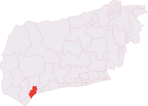
Administrative County: West Sussex

District: Arun

Police Authority: Sussex

What 3 Words

///community.asterisk.shatters. Near Selsey, West Sussex

Nearby Locations

Pagham Becket's Barn

Related Wikis

Pagham

Pagham is a coastal village, Anglican parish and civil parish in the Arun district of West Sussex, England, with a population of around 6,100. It lies...

Pagham Cricket Club Ground

Pagham Cricket Club Ground is a cricket ground in Pagham, Sussex. The first recorded match on the ground was in 1976, when Sussex played the first first...

Pagham F.C.

Pagham Football Club is a football club based in Pagham, near Bognor Regis, West Sussex, England. They are currently members of the Southern Combination...

Nyetimber Mill

Nyetimber Mill is a grade II listed tower mill at Pagham, Sussex, England which has been converted to residential use. == History == Nyetimber Mill was...
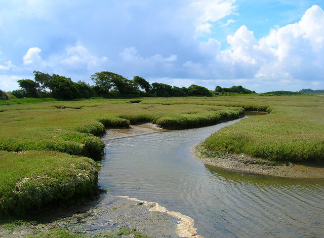
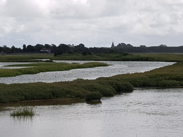
Pagham Harbour

Pagham Harbour is a 629-hectare (1,550-acre) biological and geological Site of Special Scientific Interest on the western outskirts of Bognor Regis in...

Nyetimber (electoral division)

Nyetimber is an electoral division of West Sussex in the United Kingdom and returns one member to sit on West Sussex County Council. == Extent == The division...

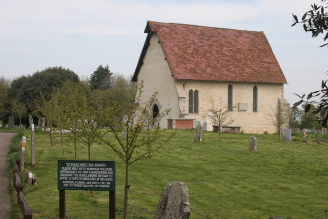
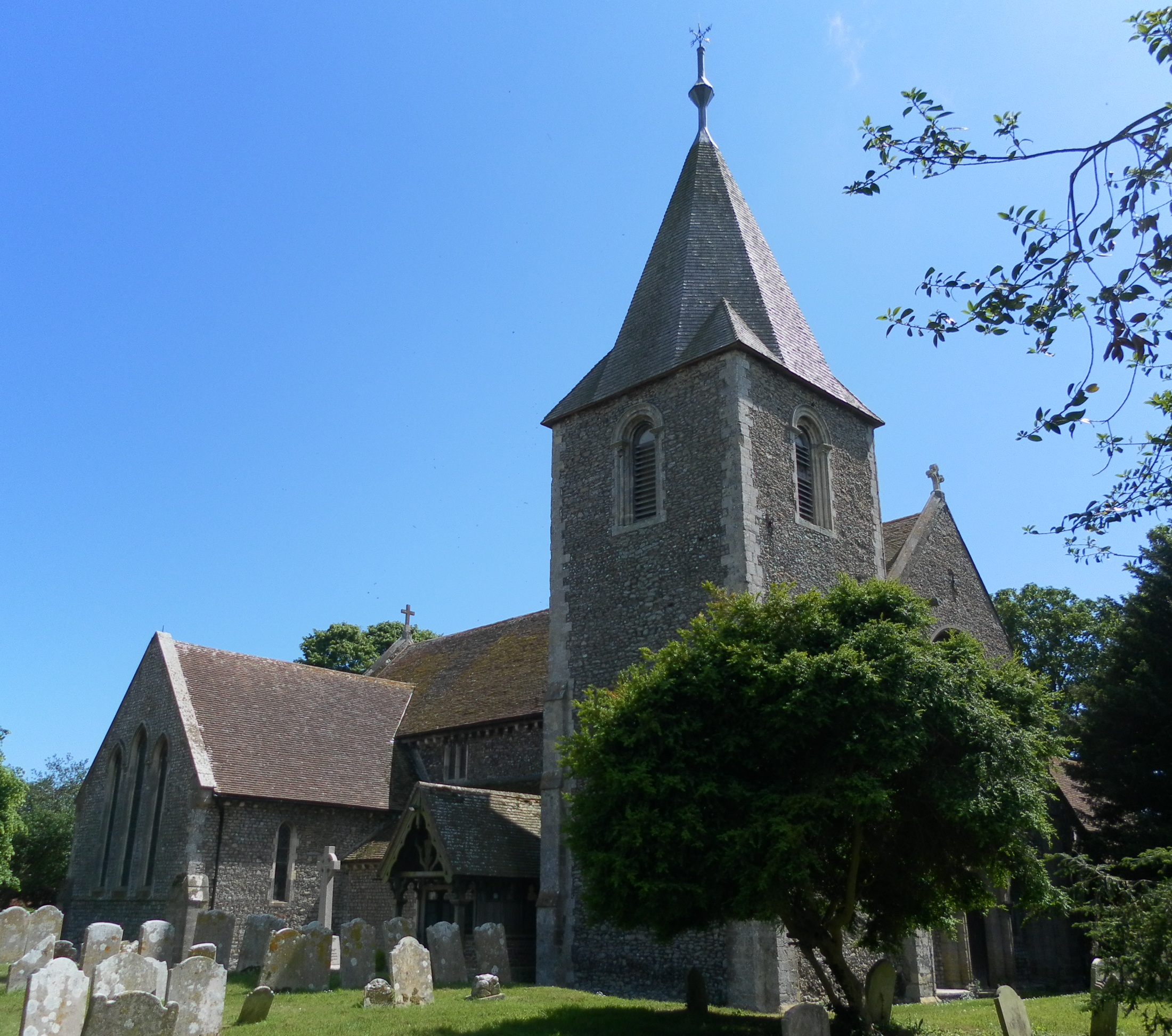
St Wilfrid's Chapel, Church Norton

St Wilfrid's Chapel, also known as St Wilfrid's Church and originally as St Peter's Church, is a former Anglican church at Church Norton, a rural location...

Selsey Abbey

Selsey Abbey was founded by St Wilfrid in AD 681 on land donated at Selsey by the local Anglo-Saxon ruler, King Æðelwealh of Sussex, Sussex's first Christian...

Related Videos

HAVEN CHURCH FARM, BOGNOR REGIS HOLIDAY VLOG | APRIL 2023

Hello :) It's been a VERY long time since I filmed a video, but with lots of persuasion from my sisters and my number one fan (my ...

Haven Perran Sands, May 2022

Haven Perran Sands, May 2022 We recently stayed at Haven Perran Sands in Perranporth, Cornwall and in this video I give you a ...

Haven Bronze Caravan Tour and Review 2022

Haven Bronze Caravan Tour and Review 2022 In this video, I take you on a tour of our bronze caravan at Haven Church Farm, ...

Nearby Amenities

Located within 500m of 50.77,-0.745
Pagham
Is In: West Sussex, England, UK
Place: village
Source: npe
Wikidata: Q2920359
Lat/Long: 50.7706947/-0.7394133
Mini Roundabout
Lat/Long: 50.7695749/-0.7460196
Bus Stop
Church Farm Caravan Park
Bus: yes
Naptan AtcoCode: 4400LH0375
Naptan Bearing: NE
Naptan BusStopType: CUS
Naptan CommonName: Church Farm Caravan Park
Naptan Indicator: opp. Sea Lane
Naptan Landmark: Sea Lane
Naptan NaptanCode: wsxdatmj
Naptan Street: Pagham Road
Naptan Verified: no
Public Transport: platform
Source: naptan_import
Lat/Long: 50.7704847/-0.7453848
Bus Stop
Church Farm Caravan Park
Bus: yes
Naptan AtcoCode: 4400LH0376
Naptan Bearing: E
Naptan CommonName: Church Farm Caravan Park
Naptan Indicator: adj Pagham Road
Naptan Landmark: Pagham Road
Naptan NaptanCode: wsxdatmp
Naptan Street: Sea Lane
Naptan Verified: no
Public Transport: platform
Source: naptan_import
Lat/Long: 50.7706739/-0.7448846
Bus Stop
The Parade
Bench: yes
Bin: no
Bus: yes
Lit: yes
Naptan AtcoCode: 4400LH0377
Naptan Bearing: S
Naptan CommonName: The Parade
Naptan Indicator: adj Woodfield Close
Naptan Landmark: Woodfield Close
Naptan NaptanCode: wsxdatmt
Naptan Street: The Parade
Naptan Verified: no
Public Transport: platform
Shelter: yes
Source: naptan_import
Tactile Paving: no
Lat/Long: 50.7696076/-0.7384474
Bus Stop
The Parade
Bench: yes
Bin: yes
Bus: yes
Lit: yes
Naptan AtcoCode: 4400LH0378
Naptan Bearing: N
Naptan CommonName: The Parade
Naptan Indicator: o/s post office
Naptan Landmark: Woodfield Close
Naptan NaptanCode: wsxdatmw
Naptan Street: The Parade
Naptan Verified: no
Public Transport: platform
Shelter: yes
Source: naptan_import
Tactile Paving: no
Lat/Long: 50.7699385/-0.7384455
Turning Circle
Lat/Long: 50.7718768/-0.7395621
The Caravan at Church Farm
Designation: Holiday Caravan
Tourism: chalet
Website: http://www.caravanatchurchfarm.co.uk
Lat/Long: 50.7701688/-0.750175
Post Box
Brand: Royal Mail
Brand Wikidata: Q638098
Brand Wikipedia: en:Royal Mail
Collection Plate: CP1
Collection Times: Mo-Fr 16:30; Sa 11:15
Operator: Royal Mail
Operator Wikidata: Q638098
Post Box Type: pillar
Ref: PO21 18
Royal Cypher: GR
Royal Cypher Wikidata: Q33102273
Source: survey
Lat/Long: 50.7707868/-0.7442414
Toilets
Check Date: 2021-07-08
Fee: no
Source: survey
Wheelchair: yes
Lat/Long: 50.7692089/-0.738226
Telephone
Booth: KX100
Check Date: 2021-07-08
Covered: booth
Source: survey
Lat/Long: 50.7661462/-0.7422623
Cafe
Pagham Beach Cafe
Addr City: Pagham
Addr Housenumber: 1
Addr Postcode: PO21 4SS
Addr Street: Harbour Road
Fhrs Authority: Arun
Fhrs Id: 292085
Fhrs Local Authority Id: 626153
Lat/Long: 50.7686787/-0.7385478
Church Farm Holiday Village
Place: locality
Source: OS OpenData StreetView
Lat/Long: 50.7677051/-0.7495553
Post Box
Brand: Royal Mail
Brand Wikidata: Q638098
Brand Wikipedia: en:Royal Mail
Collection Plate: CP1
Collection Times: Mo-Fr 16:30; Sa 11:15
Operator: Royal Mail
Operator Wikidata: Q638098
Post Box Type: pillar
Ref: PO21 45
Royal Cypher: EIIR
Royal Cypher Wikidata: Q33102113
Lat/Long: 50.7698038/-0.73857
Dentist
Pagham Harbour Dental Studio
Healthcare: dentist
Lat/Long: 50.7703917/-0.7385686
Pharmacy
Jordans Pharmacy
Addr City: Pagham
Addr Housenumber: 14-15
Addr Postcode: PO21 4TW
Addr Street: The Parade
Fhrs Authority: Arun
Fhrs Id: 521193
Fhrs Local Authority Id: 638175
Healthcare: pharmacy
Lat/Long: 50.7704595/-0.7385283
Man Made: mast
Lat/Long: 50.7724676/-0.7431716
Man Made: mast
Lat/Long: 50.7723319/-0.7433557
Man Made: mast
Lat/Long: 50.772441/-0.7432079
Historic: memorial
Memorial: war_memorial
Lat/Long: 50.7702698/-0.7482431
Restaurant
Magic Wok
Addr City: Pagham
Addr Housenumber: 20
Addr Postcode: PO21 4TW
Addr Street: The Parade
Cuisine: chinese
Fhrs Authority: Arun
Fhrs Id: 548139
Fhrs Local Authority Id: 638222
Takeaway: only
Lat/Long: 50.7706302/-0.7382083
Pagham Newsagents
Shop: newsagent
Lat/Long: 50.7706574/-0.7384028
A1 Barber Shop & Ladies Salon
Shop: hairdresser
Unisex: yes
Lat/Long: 50.7706124/-0.7384323
The Point
Shop: charity
Lat/Long: 50.770576/-0.7384577
Dentist
Pagham Dental
Healthcare: dentist
Lat/Long: 50.7705251/-0.7384913
Dapper Dogs Grooming Salon
Pet: dog
Shop: pet_grooming
Lat/Long: 50.7703207/-0.7385731
Pagham Village Stores
Addr City: Pagham
Addr Housenumber: 9
Addr Postcode: PO21 4TW
Addr Street: The Parade
Fhrs Authority: Arun
Fhrs Id: 1437918
Fhrs Local Authority Id: 9103764
Shop: convenience
Lat/Long: 50.7703012/-0.7384913
Lee Hobson Independant Funeral Service
Shop: funeral_directors
Lat/Long: 50.7702681/-0.7383478
Restaurant
Spice Paradise
Addr City: Pagham
Addr Housenumber: 6
Addr Postcode: PO21 4TW
Addr Street: The Parade
Cuisine: curry
Fhrs Authority: Arun
Fhrs Id: 1178922
Fhrs Local Authority Id: 9102489
Takeaway: yes
Lat/Long: 50.7701035/-0.7384202
Restaurant
Small Fry
Addr City: Pagham
Addr Housenumber: 5a
Addr Postcode: PO21 4TW
Addr Street: The Parade
Cuisine: fish_and_chips
Fhrs Authority: Arun
Fhrs Id: 132122
Fhrs Local Authority Id: 638108
Takeaway: only
Lat/Long: 50.7700543/-0.738443
Co-Op Pagham Funeralcare
Check Date: 2023-08-27
Shop: funeral_directors
Lat/Long: 50.7699873/-0.7384899
Ce-aire
Shop: hairdresser
Lat/Long: 50.769922/-0.7385261
Restaurant
Pagham Pizza & Kebab
Takeaway: only
Lat/Long: 50.7698847/-0.7385449
Social Facility
Angelica Care
Social Facility: ambulatory_care
Lat/Long: 50.7698491/-0.7385691
Doctors
Arthur Griffiths Clinic
Healthcare: doctor
Lat/Long: 50.7696057/-0.7381506
Pagham Service Station
Check Date: 2023-08-27
Shop: car_repair
Lat/Long: 50.7693728/-0.7383531
Pagham Autos
Check Date: 2023-08-27
Shop: car
Lat/Long: 50.7693046/-0.7383867
Generator Method: photovoltaic
Generator Output Electricity: yes
Generator Source: solar
Generator Type: solar_photovoltaic_panel
Location: roof
Power: generator
Lat/Long: 50.7708171/-0.7451918
Access: permissive
Drinking Water: yes
Man Made: water_tap
Lat/Long: 50.7702271/-0.7489351
Bar
Mash & Barrel, Show Bar, Cooks and Mini Market
Addr City: Pagham
Addr Housename: Church Farm Holiday Village
Addr Postcode: PO21 4NR
Addr Street: Church Lane
Fhrs Authority: Arun
Fhrs Id: 147137
Fhrs Local Authority Id: 9101121
Lat/Long: 50.7702927/-0.745233
The data included in this document is from www.openstreetmap.org. The data is made available under ODbL.

Have you been to Becket's Barn?

Leave your review of Becket's Barn below (or comments, questions and feedback).