Basing House

Heritage Site in Hampshire

England

Basing House

Always popular - Bartons Mill
Always popular - Bartons Mill Credit: Mr Ignavy

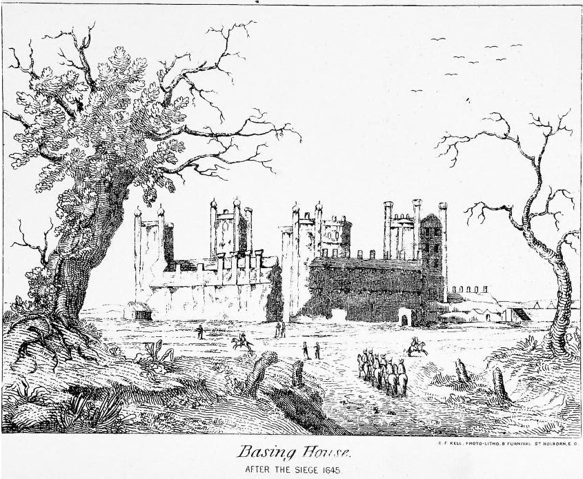
Basing House, located in the county of Hampshire, England, is a renowned heritage site that holds significant historical and cultural importance. The site is home to the ruins of a once-magnificent Tudor mansion, which was one of the largest castles in England during its prime.

Originally built in the late 13th century, Basing House became a prominent residence for several noble families over the centuries, including the influential Paulet family. However, its most memorable period was during the English Civil War in the 17th century. Basing House was staunchly loyal to the Royalist cause, and it became a strategic stronghold for King Charles I's forces.

The mansion withstood multiple sieges, including a famous one in 1645, when it was attacked by Parliamentary forces led by Oliver Cromwell himself. Despite its valiant defense, the mansion eventually fell, leading to its destruction and subsequent ruin.

Today, the ruins of Basing House stand as a testament to its tumultuous past. Visitors can explore the remains of the mansion, which include the Great Barn, the Old House, and the Tudor kitchens. The site also features a museum that showcases artifacts and provides insights into the history of Basing House and its inhabitants.

In addition to its historical significance, Basing House offers beautiful gardens and open grounds for visitors to enjoy. The site hosts various events throughout the year, such as reenactments, workshops, and guided tours, allowing visitors to immerse themselves in the history and atmosphere of this remarkable heritage site.

If you have any feedback on the listing, please let us know in the comments section below.

Basing House Images

Images are sourced within 2km of 51.267/-1.047 or Grid Reference SU6652. Thanks to Geograph Open Source API. All images are credited.

Always popular - Bartons Mill
Centre of Old Basing I wonder how the railway was received when it was first built through the old village.
Centre of Old Basing
I wonder how the railway was received when it was first built through the old village.
An old house in Old Basing
Skip road onto A339 Part of the ring road network to the east of Basingstoke.
Skip road onto A339
Part of the ring road network to the east of Basingstoke.
Approach to Black Dam Roundabout on Ringway East Southbound on the A339 in Basingstoke. Footbridge provides safe crossing for walkers on a public footpath.
Approach to Black Dam Roundabout on Ringway East
Southbound on the A339 in Basingstoke. Footbridge provides safe crossing for walkers on a public footpath.
Footbridge over the M3 The M3 motorway runs for 59 miles from Sunbury-on-Thames to Southampton. Construction started 1968 and was finally completed in 1995. The Winchester bypass through Twyford Downs was the most controversial section to be built.
Wikipedia: <span class="nowrap"><a title="http://en.wikipedia.org/wiki/M3_motorway_(Great_Britain)" rel="nofollow ugc noopener" href="http://en.wikipedia.org/wiki/M3_motorway_(Great_Britain)">Link</a><img style="margin-left:2px;" alt="External link" title="External link - shift click to open in new window" src="https://s1.geograph.org.uk/img/external.png" width="10" height="10"/></span>
Footbridge over the M3
The M3 motorway runs for 59 miles from Sunbury-on-Thames to Southampton. Construction started 1968 and was finally completed in 1995. The Winchester bypass through Twyford Downs was the most controversial section to be built. Wikipedia: LinkExternal link
M3, eastbound The M3 motorway runs for 59 miles from Sunbury-on-Thames to Southampton. Construction started 1968 and was finally completed in 1995. The Winchester bypass through Twyford Downs was the most controversial section to be built.
Wikipedia: <span class="nowrap"><a title="http://en.wikipedia.org/wiki/M3_motorway_(Great_Britain)" rel="nofollow ugc noopener" href="http://en.wikipedia.org/wiki/M3_motorway_(Great_Britain)">Link</a><img style="margin-left:2px;" alt="External link" title="External link - shift click to open in new window" src="https://s1.geograph.org.uk/img/external.png" width="10" height="10"/></span>
M3, eastbound
The M3 motorway runs for 59 miles from Sunbury-on-Thames to Southampton. Construction started 1968 and was finally completed in 1995. The Winchester bypass through Twyford Downs was the most controversial section to be built. Wikipedia: LinkExternal link
Ford at Mapledurwell This is the first of three fords along the byway at Mapledurwell.
Ford at Mapledurwell
This is the first of three fords along the byway at Mapledurwell.
Ford on the Lyde River This is the third of the three Mapledurwell fords on the byway leading down to London Road.
Ford on the Lyde River
This is the third of the three Mapledurwell fords on the byway leading down to London Road.
Ford at Mapledurwell This is the second of the three Mapledurwell fords.
Ford at Mapledurwell
This is the second of the three Mapledurwell fords.
The A339 The A339 runs for almost 35miles between Newbury in Berkshire and Alton in Hampshire. Along the way, it forms the eastern and northern parts of the Basingstoke Ring Road.

More details <span class="nowrap"><a title="http://www.sabre-roads.org.uk/wiki/index.php?title=A339" rel="nofollow ugc noopener" href="http://www.sabre-roads.org.uk/wiki/index.php?title=A339">Link</a><img style="margin-left:2px;" alt="External link" title="External link - shift click to open in new window" src="https://s1.geograph.org.uk/img/external.png" width="10" height="10"/></span>  SABRE Wiki
The A339
The A339 runs for almost 35miles between Newbury in Berkshire and Alton in Hampshire. Along the way, it forms the eastern and northern parts of the Basingstoke Ring Road. More details LinkExternal link SABRE Wiki
The A399, Ringway East The A339 runs for almost 35miles between Newbury in Berkshire and Alton in Hampshire. Along the way, it forms the eastern and northern parts of the Basingstoke Ring Road.

More details <span class="nowrap"><a title="http://www.sabre-roads.org.uk/wiki/index.php?title=A339" rel="nofollow ugc noopener" href="http://www.sabre-roads.org.uk/wiki/index.php?title=A339">Link</a><img style="margin-left:2px;" alt="External link" title="External link - shift click to open in new window" src="https://s1.geograph.org.uk/img/external.png" width="10" height="10"/></span>  SABRE Wiki
The A399, Ringway East
The A339 runs for almost 35miles between Newbury in Berkshire and Alton in Hampshire. Along the way, it forms the eastern and northern parts of the Basingstoke Ring Road. More details LinkExternal link SABRE Wiki
Heavy traffic, A339 The A339 runs for almost 35miles between Newbury in Berkshire and Alton in Hampshire. Along the way, it forms the eastern and northern parts of the Basingstoke Ring Road.

More details <span class="nowrap"><a title="http://www.sabre-roads.org.uk/wiki/index.php?title=A339" rel="nofollow ugc noopener" href="http://www.sabre-roads.org.uk/wiki/index.php?title=A339">Link</a><img style="margin-left:2px;" alt="External link" title="External link - shift click to open in new window" src="https://s1.geograph.org.uk/img/external.png" width="10" height="10"/></span>  SABRE Wiki
Heavy traffic, A339
The A339 runs for almost 35miles between Newbury in Berkshire and Alton in Hampshire. Along the way, it forms the eastern and northern parts of the Basingstoke Ring Road. More details LinkExternal link SABRE Wiki
Spur to the M3 The M3 motorway runs for 59 miles from Sunbury-on-Thames to Southampton. Construction started 1968 and was finally completed in 1995. The Winchester bypass through Twyford Downs was the most controversial section to be built.
Wikipedia: <span class="nowrap"><a title="http://en.wikipedia.org/wiki/M3_motorway_(Great_Britain)" rel="nofollow ugc noopener" href="http://en.wikipedia.org/wiki/M3_motorway_(Great_Britain)">Link</a><img style="margin-left:2px;" alt="External link" title="External link - shift click to open in new window" src="https://s1.geograph.org.uk/img/external.png" width="10" height="10"/></span>
Spur to the M3
The M3 motorway runs for 59 miles from Sunbury-on-Thames to Southampton. Construction started 1968 and was finally completed in 1995. The Winchester bypass through Twyford Downs was the most controversial section to be built. Wikipedia: LinkExternal link
Junction with the M3 The M3 motorway runs for 59 miles from Sunbury-on-Thames to Southampton. Construction started 1968 and was finally completed in 1995. The Winchester bypass through Twyford Downs was the most controversial section to be built.
Wikipedia: <span class="nowrap"><a title="http://en.wikipedia.org/wiki/M3_motorway_(Great_Britain)" rel="nofollow ugc noopener" href="http://en.wikipedia.org/wiki/M3_motorway_(Great_Britain)">Link</a><img style="margin-left:2px;" alt="External link" title="External link - shift click to open in new window" src="https://s1.geograph.org.uk/img/external.png" width="10" height="10"/></span>
Junction with the M3
The M3 motorway runs for 59 miles from Sunbury-on-Thames to Southampton. Construction started 1968 and was finally completed in 1995. The Winchester bypass through Twyford Downs was the most controversial section to be built. Wikipedia: LinkExternal link
Cutting entering Basingstoke
Basingstoke Campus See <a href="https://www.geograph.org.uk/photo/4078774">SU6452 : Framework for new offices</a> for an early view during the construction phase. The land for a while was a Park & Ride but had a short life as such and quickly became derelict.

I quote from a Network Rail newsletter - "It took 18 months to build and features 50m indoor and 120m outdoor track layouts, train driving simulators, as well as educational space to provide learning environments for railway engineers, signallers, maintenance staff and drivers.

The Basingstoke campus will also be home to the new Route Operations Centre, which will eventually operate all signalling and infrastructure for the Wessex route network." (Nov.2015)
Basingstoke Campus
See SU6452 : Framework for new offices for an early view during the construction phase. The land for a while was a Park & Ride but had a short life as such and quickly became derelict. I quote from a Network Rail newsletter - "It took 18 months to build and features 50m indoor and 120m outdoor track layouts, train driving simulators, as well as educational space to provide learning environments for railway engineers, signallers, maintenance staff and drivers. The Basingstoke campus will also be home to the new Route Operations Centre, which will eventually operate all signalling and infrastructure for the Wessex route network." (Nov.2015)
Show me another place!

Basing House is located at Grid Ref: SU6652 (Lat: 51.267, Lng: -1.047)

What 3 Words

///firms.gains.took. Near Old Basing, Hampshire

Nearby Locations

Basing House

Related Wikis

Siege of Basing House

The siege of Basing House near Basingstoke in Hampshire, was a Parliamentarian victory late in the First English Civil War. Whereas the title of the event...

Old Basing

Old Basing is a village in Hampshire, England, just east of Basingstoke. It was called Basengum in the Anglo-Saxon Chronicle and Basinges in the Domesday...

Battle of Basing

The Battle of Basing was a victory of a Danish Viking army over the West Saxons at the royal estate of Basing in Hampshire on about 22 January 871.In late...

Basing House

Basing House was a Tudor palace and castle in the village of Old Basing in the English county of Hampshire. It once rivalled Hampton Court Palace in its...

Lychpit

Lychpit is now the name of a modern housing development adjacent to Old Basing near Basingstoke, Hampshire. The modern development started in the early...

The Mill Field, Hampshire

The Mill Field is a 11.7-hectare (29-acre) Local Nature Reserve in Basingstoke in Hampshire. It is owned by Basingstoke and Deane Borough Council and...

Daneshill Park Woods

Daneshill Park Woods is a 4.4-hectare (11-acre) Local Nature Reserve in Basingstoke in Hampshire. It is owned and managed by Basingstoke and Deane Borough...

Fanum House

Fanum House is the headquarters of the Automobile Association in Basingstoke, in the English county of Hampshire. It is one of several current and former...

Nearby Amenities

Located within 500m of 51.267,-1.047
Barrier: bollard
Lat/Long: 51.2629944/-1.0445052
Crossing
Crossing Island: yes
Crossing Signals: no
Kerb: lowered
Sloped Curb: yes
Lat/Long: 51.2631275/-1.0472658
Barrier: bollard
Lat/Long: 51.2690972/-1.0430105
Pub
The Crown
Created By: Potlatch 0.4c
Wikidata: Q26385124
Lat/Long: 51.2703456/-1.0509327
Co-op Food
Addr City: Basingstoke
Addr Postcode: RG24 7HR
Addr Street: Linden Avenue
Addr Village: Old Basing
Brand: Co-op Food
Brand Wikidata: Q3277439
Operator: The Co-operative Group
Operator Wikidata: Q117202
Shop: supermarket
Website: https://www.coop.co.uk/store-finder/RG24-7HR/linden-avenue
Wheelchair: yes
Lat/Long: 51.2656522/-1.0431514
Dentist
Linden Dental Centre
Lat/Long: 51.2659016/-1.0429646
The Street Bakeshop
Shop: bakery
Lat/Long: 51.2709593/-1.049614
Barrier: kissing_gate
Lat/Long: 51.2682992/-1.0496109
Crossing
Crossing: unmarked
Crossing Island: yes
Kerb: lowered
Sloped Curb: yes
Lat/Long: 51.2629947/-1.0487238
Power: tower
Lat/Long: 51.2634357/-1.0488879
Power: tower
Lat/Long: 51.2637697/-1.0518517
Bus Stop
London Road
Bus: yes
Naptan AtcoCode: 1900HAA19825
Naptan Bearing: N
Naptan CommonName: London Road
Naptan Indicator: N-bound
Naptan NaptanCode: hamjgtmg
Naptan PlusbusZoneRef: BSNGSTK
Naptan Street: Byfleet Avenue
Naptan Verified: no
Public Transport: platform
Lat/Long: 51.2638024/-1.0426184
Old Basing
Is In: Hampshire, England, UK
Place: village
Wikidata: Q1231708
Lat/Long: 51.2712823/-1.046029
Basing House
Historic: ruins
Wikidata: Q4867508
Lat/Long: 51.2697937/-1.0522522
Traffic Signals
Traffic Signals Direction: forward
Lat/Long: 51.2689951/-1.0452841
Post Box
Collection Times: Mo-Fr 09:00; Sa 07:00
Postal Code: RG24
Ref: RG24 213
Lat/Long: 51.268369/-1.0445773
Bench
Backrest: yes
Lat/Long: 51.2688897/-1.0452415
Bench
Lat/Long: 51.2673303/-1.0517833
Bench
FIXME: approximate
Lat/Long: 51.2665026/-1.0515528
Barrier: kissing_gate
Lat/Long: 51.2666504/-1.047141
Barrier: kissing_gate
Lat/Long: 51.2690974/-1.046178
Bench
Lat/Long: 51.2691803/-1.0462846
Postal Code: RG24 7HD
Source Postal Code: planning notice
Lat/Long: 51.2676709/-1.0442
Kindergarten
NCH House
Lat/Long: 51.2655277/-1.0464857
Bench
Lat/Long: 51.265679/-1.0433438
Bus Stop
Lat/Long: 51.2671705/-1.040364
Barrier: bollard
Lat/Long: 51.2631433/-1.0465828
Barrier: kissing_gate
Lat/Long: 51.269238/-1.0485604
War Memorial
Historic: memorial
Memorial: war_memorial
Lat/Long: 51.2714629/-1.0470208
Bus Stop
Lat/Long: 51.2694734/-1.0418646
Bus Stop
Dickens Lane
Bus: yes
Naptan AtcoCode: 1900HA010344
Naptan Bearing: E
Naptan CommonName: Dickens Lane
Naptan Crossing: Park Lane
Naptan NaptanCode: hamgdpmd
Naptan PlusbusZoneRef: BSNGSTK
Naptan Street: London Road
Naptan Verified: no
Public Transport: platform
Source: naptan_import
Lat/Long: 51.2631406/-1.0477036
Bus Stop
Dickens Lane
Bus: yes
Naptan AtcoCode: 1900HA010345
Naptan Bearing: W
Naptan CommonName: Dickens Lane
Naptan Crossing: Park Lane
Naptan NaptanCode: hamgdpjw
Naptan PlusbusZoneRef: BSNGSTK
Naptan Street: London Road
Naptan Verified: no
Public Transport: platform
Source: naptan_import
Lat/Long: 51.2629894/-1.0478605
Bus Stop
Blenheim Road
Naptan AtcoCode: 1900HA010348
Naptan Bearing: NW
Naptan CommonName: Blenheim Road
Naptan Crossing: Blenheim Road
Naptan NaptanCode: hamgdtpd
Naptan PlusbusZoneRef: BSNGSTK
Naptan Street: Hatch Lane
Naptan Verified: no
Source: naptan_import
Lat/Long: 51.2671007/-1.0404117
Blenheim Road
Naptan AtcoCode: 1900HA010349
Naptan Bearing: SE
Naptan BusStopType: CUS
Naptan CommonName: Blenheim Road
Naptan Crossing: Blenheim Road
Naptan NaptanCode: hamgdtmg
Naptan PlusbusZoneRef: BSNGSTK
Naptan Street: Hatch Lane
Naptan Verified: no
Source: naptan_import
Lat/Long: 51.2674212/-1.0411217
Bus Stop
Fiveways
Naptan AtcoCode: 1900HA010350
Naptan Bearing: NW
Naptan CommonName: Fiveways
Naptan Crossing: Park Lane
Naptan NaptanCode: hamgdpwg
Naptan PlusbusZoneRef: BSNGSTK
Naptan Street: Crown Lane
Naptan Verified: no
Source: naptan_import
Lat/Long: 51.2690411/-1.0456751
Bus Stop
Fiveways
Naptan AtcoCode: 1900HA010351
Naptan Bearing: E
Naptan CommonName: Fiveways
Naptan Crossing: Milkingpen Lane
Naptan NaptanCode: hamgdptp
Naptan PlusbusZoneRef: BSNGSTK
Naptan Street: Crown Lane
Naptan Verified: no
Source: naptan_import
Lat/Long: 51.2692722/-1.0464444
Bus Stop
Belle Vue Road
Bus: yes
Naptan AtcoCode: 1900HA010352
Naptan Bearing: N
Naptan CommonName: Belle Vue Road
Naptan Crossing: The Mead
Naptan NaptanCode: hamgdtaj
Naptan PlusbusZoneRef: BSNGSTK
Naptan ShortCommonName: Old Basing Infant School
Naptan Street: Milkingpen Lane
Naptan Verified: no
Public Transport: platform
Source: naptan_import
Lat/Long: 51.2703012/-1.0447172
Bus Stop
Fraser Close
Bus: yes
Naptan AtcoCode: 1900HA010354
Naptan Bearing: SE
Naptan CommonName: Fraser Close
Naptan Crossing: Fraser Close
Naptan NaptanCode: hamgdtjt
Naptan PlusbusZoneRef: BSNGSTK
Naptan Street: Belle Vue Road
Naptan Verified: no
Public Transport: platform
Source: naptan_import
Lat/Long: 51.2691271/-1.0407995
Bus Stop
Fraser Close
Naptan AtcoCode: 1900HA010355
Naptan Bearing: NW
Naptan CommonName: Fraser Close
Naptan Crossing: Loyalty Lane
Naptan Landmark: Belle Vue Rd Shops
Naptan NaptanCode: hamgdtmt
Naptan PlusbusZoneRef: BSNGSTK
Naptan Street: Belle Vue Road
Naptan Verified: no
Source: naptan_import
Lat/Long: 51.2690919/-1.0408863
Bus Stop
The British Legion
Naptan AtcoCode: 1900HA010362
Naptan Bearing: W
Naptan CommonName: The British Legion
Naptan Crossing: Musket Copse
Naptan NaptanCode: hamgdpjm
Naptan PlusbusZoneRef: BSNGSTK
Naptan Street: Crown Lane
Naptan Verified: no
Source: naptan_import
Lat/Long: 51.2695095/-1.0479876
Bus Stop
The British Legion
Naptan AtcoCode: 1900HA010363
Naptan Bearing: E
Naptan CommonName: The British Legion
Naptan Crossing: Musket Copse
Naptan NaptanCode: hamgdpjg
Naptan PlusbusZoneRef: BSNGSTK
Naptan Street: Crown Lane
Naptan Verified: no
Source: naptan_import
Lat/Long: 51.2696259/-1.0479658
Bus Stop
The Crown Ph
Naptan AtcoCode: 1900HA010364
Naptan Bearing: W
Naptan CommonName: The Crown Ph
Naptan Crossing: Bexmoor Way
Naptan NaptanCode: hamgdpdg
Naptan PlusbusZoneRef: BSNGSTK
Naptan Street: The Street
Naptan Verified: no
Source: naptan_import
Lat/Long: 51.270371/-1.0510949
Bus Stop
Old Basing Bakery
Naptan AtcoCode: 1900HA010366
Naptan Bearing: W
Naptan CommonName: Old Basing Bakery
Naptan Crossing: Crown Lane
Naptan NaptanCode: hamgdpgp
Naptan PlusbusZoneRef: BSNGSTK
Naptan Street: The Street
Naptan Verified: no
Source: naptan_import
Lat/Long: 51.2706949/-1.0499987
Bus Stop
Old Basing Bakery
Naptan AtcoCode: 1900HA010367
Naptan Bearing: E
Naptan CommonName: Old Basing Bakery
Naptan Crossing: Crown Lane
Naptan NaptanCode: hamgdpja
Naptan PlusbusZoneRef: BSNGSTK
Naptan Street: The Street
Naptan Verified: no
Source: naptan_import
Lat/Long: 51.2708014/-1.0498245
Bus Stop
Belle Vue Road
Naptan AtcoCode: 1900HAA10036
Naptan Bearing: N
Naptan CommonName: Belle Vue Road
Naptan Crossing: Opp The Mead
Naptan Landmark: Old Basing Infant School
Naptan NaptanCode: hamjmgaw
Naptan PlusbusZoneRef: BSNGSTK
Naptan Street: Milkingpen Lane
Naptan Verified: no
Source: naptan_import
Lat/Long: 51.2701744/-1.0446052
Bus Stop
Fiveways
Naptan AtcoCode: 1900HAA10038
Naptan Bearing: N
Naptan CommonName: Fiveways
Naptan Crossing: Hatch Lane
Naptan NaptanCode: hamjmgdg
Naptan Street: Byfleet Avenue
Naptan Verified: no
Source: naptan_import
Lat/Long: 51.2681053/-1.0445047
Bus Stop
Linden Avenue
Naptan AtcoCode: 1900HAA10039
Naptan Bearing: N
Naptan CommonName: Linden Avenue
Naptan Crossing: Linden Avenue
Naptan NaptanCode: hamjmgdj
Naptan PlusbusZoneRef: BSNGSTK
Naptan Street: Byfleet Avenue
Naptan Verified: no
Source: naptan_import
Lat/Long: 51.2659839/-1.0435024
Bus Stop
Fiveways
Bus: yes
Naptan AtcoCode: 1900HAA13435
Naptan Bearing: S
Naptan CommonName: Fiveways
Naptan Crossing: Park Lane
Naptan NaptanCode: hamgdtag
Naptan PlusbusZoneRef: BSNGSTK
Naptan Street: Byfleet Avenue
Naptan Verified: no
Public Transport: platform
Source: naptan_import
Lat/Long: 51.2679802/-1.0445933
Bus Stop
London Road
Bus: yes
Naptan AtcoCode: 1900HAA19826
Naptan Bearing: S
Naptan CommonName: London Road
Naptan Crossing: London Road
Naptan NaptanCode: hamjgtmj
Naptan PlusbusZoneRef: BSNGSTK
Naptan Street: Byfleet Avenue
Naptan Verified: no
Public Transport: platform
Source: naptan_import
Lat/Long: 51.2636099/-1.0423907
Bus Stop
Linden Avenue
Bus: yes
Naptan AtcoCode: 1900HAA19827
Naptan Bearing: NW
Naptan CommonName: Linden Avenue
Naptan Crossing: Linden Avenue
Naptan NaptanCode: hamjgtmp
Naptan PlusbusZoneRef: BSNGSTK
Naptan Street: Byfleet Avenue
Naptan Verified: no
Public Transport: platform
Source: naptan_import
Lat/Long: 51.2660212/-1.0436593
Crossing
Crossing: uncontrolled
Kerb: lowered
Sloped Curb: yes
Lat/Long: 51.2690211/-1.0448777
Traffic Signals
Traffic Signals Direction: forward
Lat/Long: 51.2687069/-1.0451504
Crossing
Crossing: uncontrolled
Kerb: lowered
Sloped Curb: yes
Lat/Long: 51.2689857/-1.0452354
Traffic Signals
Traffic Signals Direction: backward
Lat/Long: 51.2686719/-1.0448404
Crossing
Crossing: uncontrolled
Kerb: lowered
Sloped Curb: yes
Lat/Long: 51.2688769/-1.0446551
Traffic Signals
Traffic Signals Direction: backward
Lat/Long: 51.2691302/-1.0448487
Barrier: kissing_gate
Lat/Long: 51.2685999/-1.045288
Crossing
Crossing: uncontrolled
Kerb: lowered
Sloped Curb: yes
Lat/Long: 51.2687042/-1.0448542
Crossing
Crossing: uncontrolled
Kerb: lowered
Sloped Curb: yes
Lat/Long: 51.2687407/-1.0451309
Traffic Signals
Traffic Signals Direction: backward
Lat/Long: 51.2688667/-1.044599
Crossing
Crossing: uncontrolled
Kerb: lowered
Sloped Curb: yes
Lat/Long: 51.262975/-1.0482219
Bus Stop
Byfleet Avenue
Bus: yes
Naptan AtcoCode: 1900HAA91361
Naptan NaptanCode: hamjtagd
Public Transport: platform
Lat/Long: 51.2657639/-1.0425765
Crossing
Crossing: uncontrolled
Lanes: 1
Traffic Calming: choker
Lat/Long: 51.2694633/-1.0476189
Crossing
Crossing: uncontrolled
Lat/Long: 51.2702924/-1.0433452
Colour: red
Marker: post
Lat/Long: 51.2702573/-1.0502951
Parking
Access: customers
Parking: surface
Lat/Long: 51.2704051/-1.0508798
Parking Space
Capacity: 1
Parking Space: disabled
Lat/Long: 51.2704043/-1.0507015
Parking
Access: private
Parking: surface
Lat/Long: 51.2713363/-1.0454241
Grit Bin
Lat/Long: 51.2713424/-1.0455138
Barrier: kissing_gate
Foot: yes
Motor Vehicle: no
Lat/Long: 51.263224/-1.0502519
The data included in this document is from www.openstreetmap.org. The data is made available under ODbL.

Have you been to Basing House?

Leave your review of Basing House below (or comments, questions and feedback).