Arnot House
Heritage Site in Yorkshire
England
Arnot House

Arnot House, located in Yorkshire, England, is a historic heritage site that holds great significance in the region. Dating back to the 17th century, this stunning house has witnessed numerous transformations and played a vital role in the local community.
Built in the Jacobean architectural style, Arnot House stands as a testament to the grandeur and elegance of the era. The house boasts a symmetrical façade adorned with intricate stone carvings and large windows, allowing ample natural light to penetrate the interior. The surrounding gardens, meticulously landscaped, provide a picturesque backdrop to the house.
Throughout its history, Arnot House has served various purposes. Originally a family residence for wealthy landowners, it later became a temporary shelter for displaced families during World War II. Today, the house is open to the public as a heritage site and museum, offering visitors a glimpse into the past.
Inside, the house showcases a vast collection of artifacts and exhibits, illustrating the rich cultural heritage of Yorkshire. From antique furniture and paintings to historical documents and photographs, every corner of Arnot House tells a unique story. Guided tours are available, providing visitors with insightful narratives about the house and its former inhabitants.
Arnot House also hosts special events and activities throughout the year, including workshops, lectures, and exhibitions. These events aim to engage the local community and promote an understanding of the region's history and heritage.
In conclusion, Arnot House stands as a remarkable heritage site in Yorkshire, offering visitors an opportunity to explore the architectural beauty of the past and delve into the rich history of the region.
If you have any feedback on the listing, please let us know in the comments section below.
Arnot House Images
Images are sourced within 2km of 53.905/-2.342 or Grid Reference SD7745. Thanks to Geograph Open Source API. All images are credited.
![Sawley village and abbey [1] An information board about the abbey.
Sawley is a small village on the banks of the River Ribble, some 3½ miles northeast of Clitheroe. The village is dominated by the ruins of the Cistercian abbey founded in 1148. The abbey was dissolved in 1536 and mostly demolished, the stone taken and reused in neighbouring farms and cottages. The ruins are now in the care of English Heritage. The abbey remains are listed, grade I, with details at: <span class="nowrap"><a title="https://historicengland.org.uk/listing/the-list/list-entry/1072099" rel="nofollow ugc noopener" href="https://historicengland.org.uk/listing/the-list/list-entry/1072099">Link</a><img style="margin-left:2px;" alt="External link" title="External link - shift click to open in new window" src="https://s1.geograph.org.uk/img/external.png" width="10" height="10"/></span> The site is a Scheduled Ancient Monument with much detail at: <span class="nowrap"><a title="https://historicengland.org.uk/listing/the-list/list-entry/1015492" rel="nofollow ugc noopener" href="https://historicengland.org.uk/listing/the-list/list-entry/1015492">Link</a><img style="margin-left:2px;" alt="External link" title="External link - shift click to open in new window" src="https://s1.geograph.org.uk/img/external.png" width="10" height="10"/></span>](https://s0.geograph.org.uk/geophotos/07/02/65/7026512_73de4ce8.jpg)
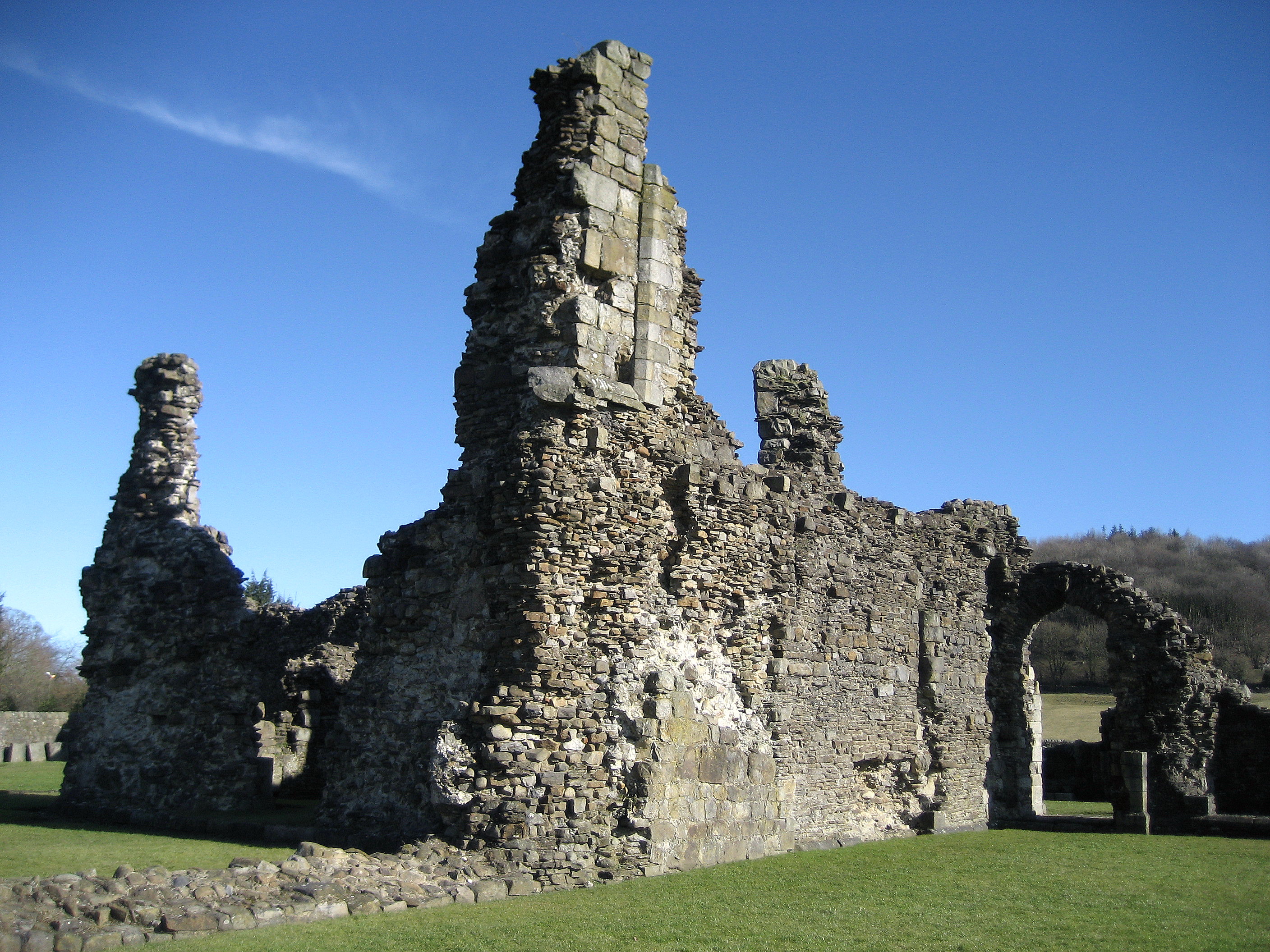
![Sawley village and abbey [2] The ruins of the abbey church.
Sawley is a small village on the banks of the River Ribble, some 3½ miles northeast of Clitheroe. The village is dominated by the ruins of the Cistercian abbey founded in 1148. The abbey was dissolved in 1536 and mostly demolished, the stone taken and reused in neighbouring farms and cottages. The ruins are now in the care of English Heritage. The abbey remains are listed, grade I, with details at: <span class="nowrap"><a title="https://historicengland.org.uk/listing/the-list/list-entry/1072099" rel="nofollow ugc noopener" href="https://historicengland.org.uk/listing/the-list/list-entry/1072099">Link</a><img style="margin-left:2px;" alt="External link" title="External link - shift click to open in new window" src="https://s1.geograph.org.uk/img/external.png" width="10" height="10"/></span> The site is a Scheduled Ancient Monument with much detail at: <span class="nowrap"><a title="https://historicengland.org.uk/listing/the-list/list-entry/1015492" rel="nofollow ugc noopener" href="https://historicengland.org.uk/listing/the-list/list-entry/1015492">Link</a><img style="margin-left:2px;" alt="External link" title="External link - shift click to open in new window" src="https://s1.geograph.org.uk/img/external.png" width="10" height="10"/></span>](https://s1.geograph.org.uk/geophotos/07/02/65/7026513_b5890db0.jpg)
![Sawley village and abbey [3] An information board about the abbey.
Sawley is a small village on the banks of the River Ribble, some 3½ miles northeast of Clitheroe. The village is dominated by the ruins of the Cistercian abbey founded in 1148. The abbey was dissolved in 1536 and mostly demolished, the stone taken and reused in neighbouring farms and cottages. The ruins are now in the care of English Heritage. The abbey remains are listed, grade I, with details at: <span class="nowrap"><a title="https://historicengland.org.uk/listing/the-list/list-entry/1072099" rel="nofollow ugc noopener" href="https://historicengland.org.uk/listing/the-list/list-entry/1072099">Link</a><img style="margin-left:2px;" alt="External link" title="External link - shift click to open in new window" src="https://s1.geograph.org.uk/img/external.png" width="10" height="10"/></span> The site is a Scheduled Ancient Monument with much detail at: <span class="nowrap"><a title="https://historicengland.org.uk/listing/the-list/list-entry/1015492" rel="nofollow ugc noopener" href="https://historicengland.org.uk/listing/the-list/list-entry/1015492">Link</a><img style="margin-left:2px;" alt="External link" title="External link - shift click to open in new window" src="https://s1.geograph.org.uk/img/external.png" width="10" height="10"/></span>](https://s3.geograph.org.uk/geophotos/07/02/65/7026515_6052e2c8.jpg)
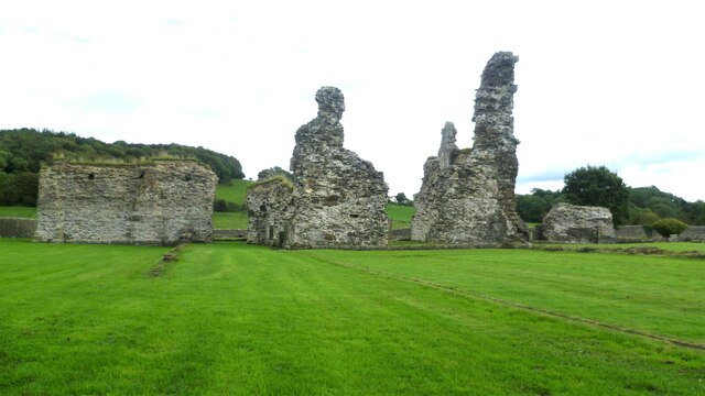
![Sawley village and abbey [4] The ruins of some of the monk&#039;s accommodation.
Sawley is a small village on the banks of the River Ribble, some 3½ miles northeast of Clitheroe. The village is dominated by the ruins of the Cistercian abbey founded in 1148. The abbey was dissolved in 1536 and mostly demolished, the stone taken and reused in neighbouring farms and cottages. The ruins are now in the care of English Heritage. The abbey remains are listed, grade I, with details at: <span class="nowrap"><a title="https://historicengland.org.uk/listing/the-list/list-entry/1072099" rel="nofollow ugc noopener" href="https://historicengland.org.uk/listing/the-list/list-entry/1072099">Link</a><img style="margin-left:2px;" alt="External link" title="External link - shift click to open in new window" src="https://s1.geograph.org.uk/img/external.png" width="10" height="10"/></span> The site is a Scheduled Ancient Monument with much detail at: <span class="nowrap"><a title="https://historicengland.org.uk/listing/the-list/list-entry/1015492" rel="nofollow ugc noopener" href="https://historicengland.org.uk/listing/the-list/list-entry/1015492">Link</a><img style="margin-left:2px;" alt="External link" title="External link - shift click to open in new window" src="https://s1.geograph.org.uk/img/external.png" width="10" height="10"/></span>](https://s0.geograph.org.uk/geophotos/07/02/65/7026516_b62c5d29.jpg)
![Sawley village and abbey [5] The remains of part of the floor of the abbey church.
Sawley is a small village on the banks of the River Ribble, some 3½ miles northeast of Clitheroe. The village is dominated by the ruins of the Cistercian abbey founded in 1148. The abbey was dissolved in 1536 and mostly demolished, the stone taken and reused in neighbouring farms and cottages. The ruins are now in the care of English Heritage. The abbey remains are listed, grade I, with details at: <span class="nowrap"><a title="https://historicengland.org.uk/listing/the-list/list-entry/1072099" rel="nofollow ugc noopener" href="https://historicengland.org.uk/listing/the-list/list-entry/1072099">Link</a><img style="margin-left:2px;" alt="External link" title="External link - shift click to open in new window" src="https://s1.geograph.org.uk/img/external.png" width="10" height="10"/></span> The site is a Scheduled Ancient Monument with much detail at: <span class="nowrap"><a title="https://historicengland.org.uk/listing/the-list/list-entry/1015492" rel="nofollow ugc noopener" href="https://historicengland.org.uk/listing/the-list/list-entry/1015492">Link</a><img style="margin-left:2px;" alt="External link" title="External link - shift click to open in new window" src="https://s1.geograph.org.uk/img/external.png" width="10" height="10"/></span>](https://s1.geograph.org.uk/geophotos/07/02/65/7026517_7643acc2.jpg)
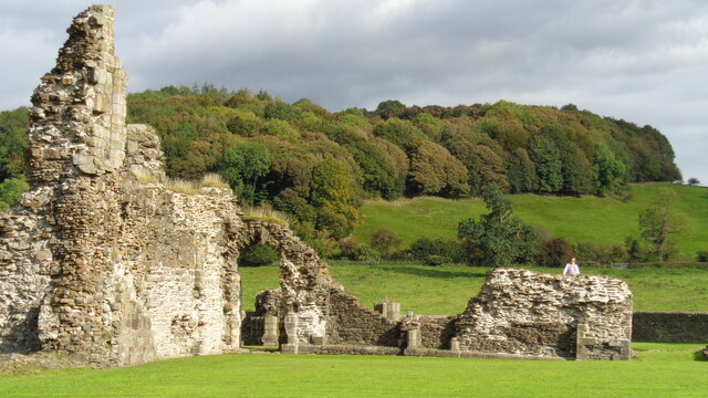
![Sawley village and abbey [6] The remains of the abbey church.
Sawley is a small village on the banks of the River Ribble, some 3½ miles northeast of Clitheroe. The village is dominated by the ruins of the Cistercian abbey founded in 1148. The abbey was dissolved in 1536 and mostly demolished, the stone taken and reused in neighbouring farms and cottages. The ruins are now in the care of English Heritage. The abbey remains are listed, grade I, with details at: <span class="nowrap"><a title="https://historicengland.org.uk/listing/the-list/list-entry/1072099" rel="nofollow ugc noopener" href="https://historicengland.org.uk/listing/the-list/list-entry/1072099">Link</a><img style="margin-left:2px;" alt="External link" title="External link - shift click to open in new window" src="https://s1.geograph.org.uk/img/external.png" width="10" height="10"/></span> The site is a Scheduled Ancient Monument with much detail at: <span class="nowrap"><a title="https://historicengland.org.uk/listing/the-list/list-entry/1015492" rel="nofollow ugc noopener" href="https://historicengland.org.uk/listing/the-list/list-entry/1015492">Link</a><img style="margin-left:2px;" alt="External link" title="External link - shift click to open in new window" src="https://s1.geograph.org.uk/img/external.png" width="10" height="10"/></span>](https://s3.geograph.org.uk/geophotos/07/02/65/7026519_f683a7e7.jpg)
![Sawley village and abbey [7] Fragments of carved stone in storage.
Sawley is a small village on the banks of the River Ribble, some 3½ miles northeast of Clitheroe. The village is dominated by the ruins of the Cistercian abbey founded in 1148. The abbey was dissolved in 1536 and mostly demolished, the stone taken and reused in neighbouring farms and cottages. The ruins are now in the care of English Heritage. The abbey remains are listed, grade I, with details at: <span class="nowrap"><a title="https://historicengland.org.uk/listing/the-list/list-entry/1072099" rel="nofollow ugc noopener" href="https://historicengland.org.uk/listing/the-list/list-entry/1072099">Link</a><img style="margin-left:2px;" alt="External link" title="External link - shift click to open in new window" src="https://s1.geograph.org.uk/img/external.png" width="10" height="10"/></span> The site is a Scheduled Ancient Monument with much detail at: <span class="nowrap"><a title="https://historicengland.org.uk/listing/the-list/list-entry/1015492" rel="nofollow ugc noopener" href="https://historicengland.org.uk/listing/the-list/list-entry/1015492">Link</a><img style="margin-left:2px;" alt="External link" title="External link - shift click to open in new window" src="https://s1.geograph.org.uk/img/external.png" width="10" height="10"/></span>](https://s0.geograph.org.uk/geophotos/07/02/65/7026520_b94ddb19.jpg)
![Sawley village and abbey [8] This delightful former school, which closed in 1976, is now the village hall.
Sawley is a small village on the banks of the River Ribble, some 3½ miles northeast of Clitheroe. The village is dominated by the ruins of the Cistercian abbey founded in 1148. The abbey was dissolved in 1536 and mostly demolished, the stone taken and reused in neighbouring farms and cottages. The ruins are now in the care of English Heritage.](https://s3.geograph.org.uk/geophotos/07/02/65/7026539_8fb6ee9f.jpg)

![Sawley village and abbey [9] A row of houses in rubble stone under a stone slate roof.
Sawley is a small village on the banks of the River Ribble, some 3½ miles northeast of Clitheroe. The village is dominated by the ruins of the Cistercian abbey founded in 1148. The abbey was dissolved in 1536 and mostly demolished, the stone taken and reused in neighbouring farms and cottages. The ruins are now in the care of English Heritage.](https://s0.geograph.org.uk/geophotos/07/02/65/7026548_2fc290cc.jpg)
Arnot House is located at Grid Ref: SD7745 (Lat: 53.905, Lng: -2.342)
Division: West Riding
What 3 Words
///brew.cuddling.balanced. Near Chatburn, Lancashire
Nearby Locations
Related Wikis
Sawley Abbey
Sawley Abbey was an abbey of Cistercian monks in the village of Sawley, Lancashire, in England (and historically in the West Riding of Yorkshire). Created...

Bowland High
Bowland High is a coeducational secondary school with academy status, located in Grindleton in Lancashire, England. It educates pupils from ages 11–16...

Sawley, Lancashire
Sawley is a village and civil parish in the Borough of Ribble Valley in Lancashire, England. The population of the civil parish was 305 at the 2001 Census...
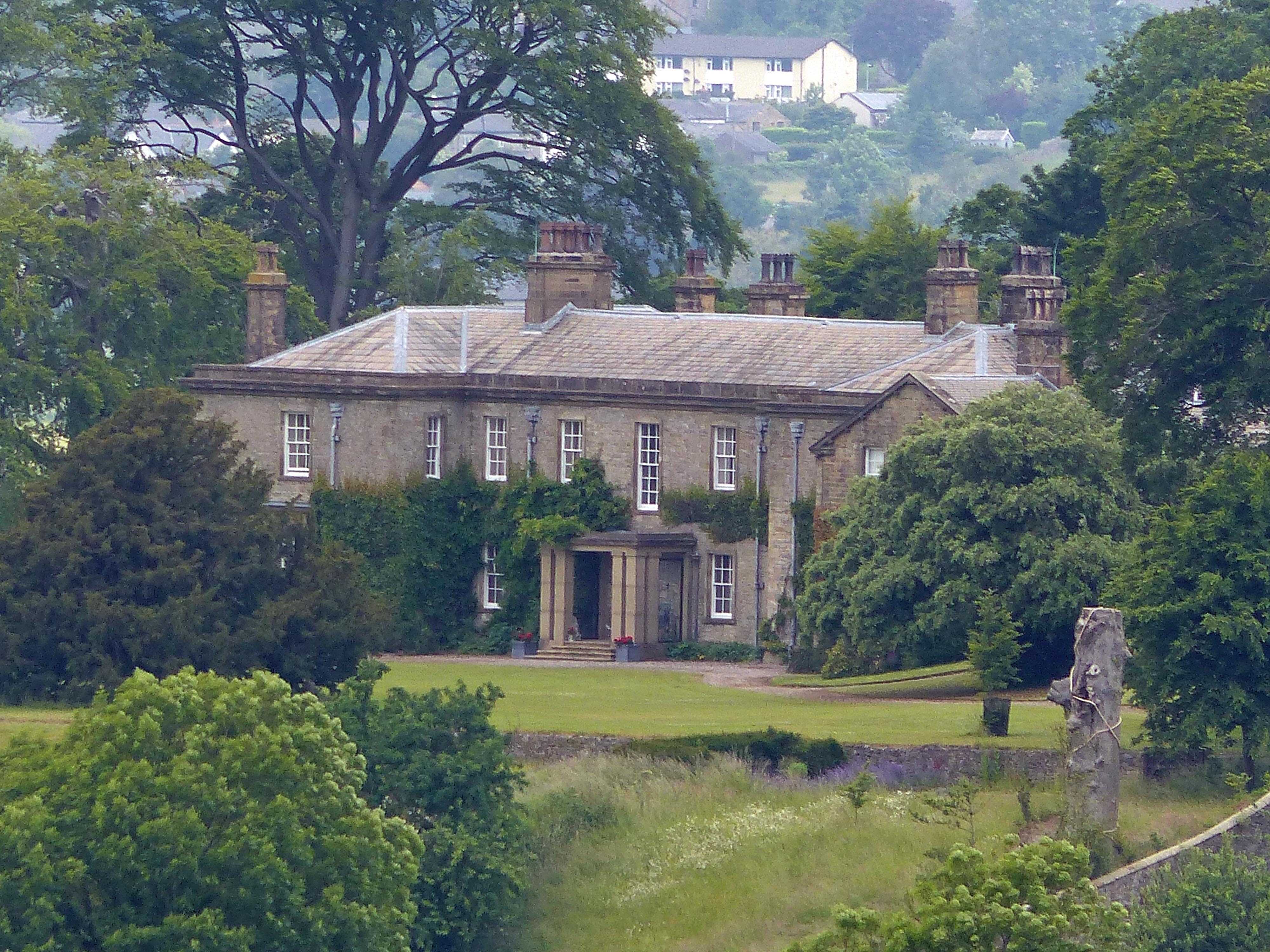
Downham Hall
Downham Hall is an English country house in Downham, Lancashire, England. == Overview == Downham Hall was designed by George Webster (1797–1864) in 1835...

Christ Church, Chatburn
Christ Church is in the village of Chatburn, Lancashire, England. It is an active Anglican parish church in the deanery of Whalley, the archdeaconry of...
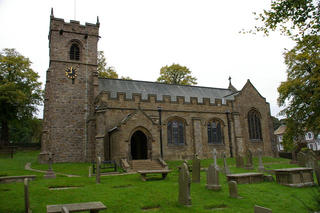
St Ambrose's Church, Grindleton
St Ambrose's Church is in the village of Grindleton, which is situated about 3 miles (5 km) northeast of Clitheroe, Lancashire, England. It is an active...
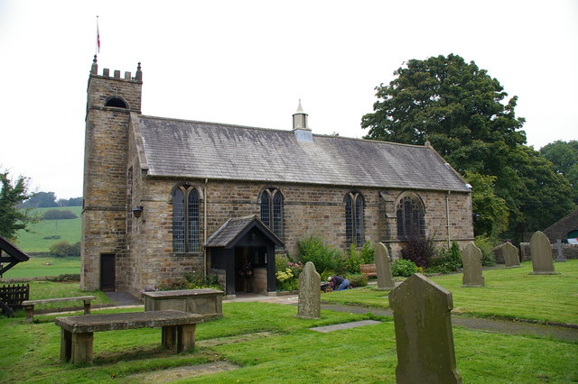
St Leonard's Church, Downham
St Leonard's Church is in the village of Downham, Lancashire, England. It is an active Anglican parish church in the diocese of Blackburn. The tower...

Chatburn
Chatburn is a village, civil parish and electoral ward in the Ribble Valley, East Lancashire, England. The population of the civil parish at the 2011 census...
Nearby Amenities
Located within 500m of 53.905,-2.342Have you been to Arnot House?
Leave your review of Arnot House below (or comments, questions and feedback).