An Dùn

Heritage Site in Argyllshire

Scotland

An Dùn

Limestone and flowers, Druim Mòr A long limestone ridge at the south end of Lismore.
Limestone and flowers, Druim Mòr Credit: Richard Webb

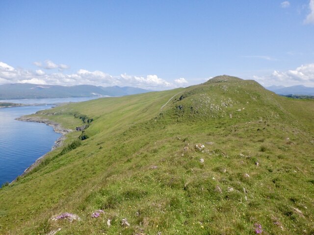
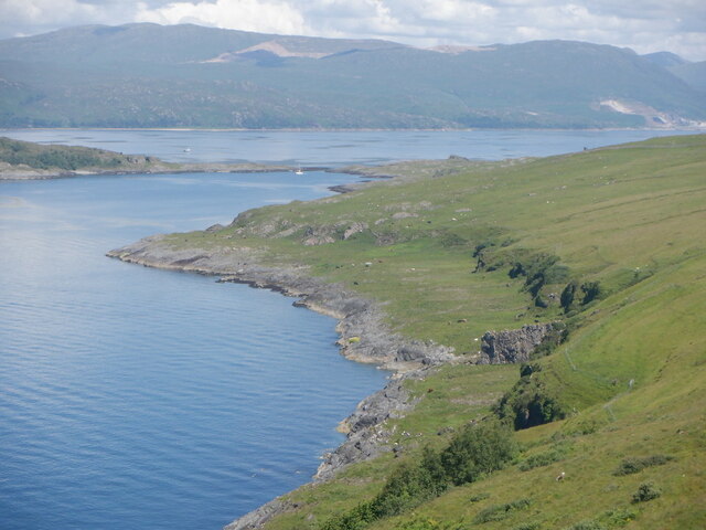
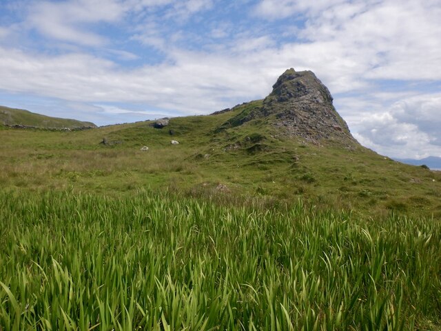
An Dùn, located in Argyllshire, Scotland, is a historical heritage site that holds significant cultural and historical value. Perched on a hilltop overlooking the stunning Loch Creran, An Dùn is a well-preserved ancient hillfort dating back to the Iron Age.

The site features a circular fortification surrounded by a stone wall, measuring about 60 meters in diameter. The walls, constructed with large stones without the use of mortar, have withstood the test of time, standing proudly as a testament to the engineering skills of its ancient inhabitants.

The interior of An Dùn contains the remnants of several roundhouses, indicating that it was once a bustling settlement. These roundhouses, made from timber and thatch, served as dwellings for the ancient inhabitants and were arranged in a circular pattern within the fortification.

Visitors to An Dùn can explore the site and take in the breathtaking views of the surrounding landscape. The hillfort offers a glimpse into the daily lives and defensive strategies of the Iron Age people who inhabited the area.

An Dùn is a protected heritage site and is managed by local authorities to ensure its preservation for future generations. It serves as an important educational resource, allowing visitors to learn about the rich history and cultural heritage of the region.

With its picturesque location and historical significance, An Dùn is a must-visit destination for history enthusiasts, archaeology buffs, and nature lovers alike. It offers a unique opportunity to step back in time and experience the ancient past of Argyllshire.

If you have any feedback on the listing, please let us know in the comments section below.

An Dùn Images

Images are sourced within 2km of 56.468/-5.58 or Grid Reference NM7936. Thanks to Geograph Open Source API. All images are credited.

Limestone and flowers, Druim Mòr A long limestone ridge at the south end of Lismore.
Limestone and flowers, Druim Mòr
A long limestone ridge at the south end of Lismore.
Cnoc Sneachdach, Lismore The high (by Lismore standards) ridge running along the south of the island.
Cnoc Sneachdach, Lismore
The high (by Lismore standards) ridge running along the south of the island.
Bàgh Clach an Dobhrain The west side of Lismore in part of the island depopulated by clearance. This is a very good example of a raised beach. 
The Glensanda quarry is visible beyond the anchorage and Bernera Island.
Bàgh Clach an Dobhrain
The west side of Lismore in part of the island depopulated by clearance. This is a very good example of a raised beach. The Glensanda quarry is visible beyond the anchorage and Bernera Island.
The Fiart Road, Lismore The south of the island running down to Dalnarrow through fine limestone scenery.
The Fiart Road, Lismore
The south of the island running down to Dalnarrow through fine limestone scenery.
The Fiart Road, Lismore The road to Dalnarrow passing through fine limestone scenery.
The Fiart Road, Lismore
The road to Dalnarrow passing through fine limestone scenery.
Dyke, Druim Mòr Igneous rock from the Mull or Ardnamurchan complex is raised above the older limestone.
Dyke, Druim Mòr
Igneous rock from the Mull or Ardnamurchan complex is raised above the older limestone.
Cattle, Dalnarrow
Cattle, Dalnarrow
Raised beach near Port Chruban View from Dun Chruban towards the lighthouse on Eilean Musdile.
Raised beach near Port Chruban
View from Dun Chruban towards the lighthouse on Eilean Musdile.
Wall, Dun Chruban Fort near Dalnarrow at the southern end of Lismore.
Wall, Dun Chruban
Fort near Dalnarrow at the southern end of Lismore.
Port Chruban, Lismore View from the ruins of Dun Chruban.
Port Chruban, Lismore
View from the ruins of Dun Chruban.
Road to Port an Rubha The road through the southern reaches of Lismore, an area badly affected by clearance. It is more path like after Dalnarrow.
Road to Port an Rubha
The road through the southern reaches of Lismore, an area badly affected by clearance. It is more path like after Dalnarrow.
Limestone slabs, Port an Rubha There are two limestone ridges at the southern end of Lismore. These are former sea cliffs on the eastern ridge.
Limestone slabs, Port an Rubha
There are two limestone ridges at the southern end of Lismore. These are former sea cliffs on the eastern ridge.
Former headland, Lismore Looking up at one of the two limestone ridges from a raised beach at the south end of Lismore.
Former headland, Lismore
Looking up at one of the two limestone ridges from a raised beach at the south end of Lismore.
Port an Rubha A beach near the southern end of Lismore.
Port an Rubha
A beach near the southern end of Lismore.
A field between the ridges The fences are tatty now but there were enclosed fields between the two limestone ridges in the south of Lismore.
A field between the ridges
The fences are tatty now but there were enclosed fields between the two limestone ridges in the south of Lismore.
Field, south end of Lismore
Cattle, Dalnarrow Southern end of Lismore.
Cattle, Dalnarrow
Southern end of Lismore.
Limestone scenery, Lismore The road from Dalnarrow passes between two limestone ridges.
Limestone scenery, Lismore
The road from Dalnarrow passes between two limestone ridges.
Show me another place!

An Dùn is located at Grid Ref: NM7936 (Lat: 56.468, Lng: -5.58)

Unitary Authority: Argyll and Bute

Police Authority: Argyll and West Dunbartonshire

What 3 Words

///jumped.crunching.glow. Near Craignure, Argyll & Bute

Nearby Locations

Gleann Beithe An Dùn

Related Wikis

Eilean Musdile

Eilean Musdile (Mansedale) is an islet, and lighthouse to the south west of Lismore in the Inner Hebrides. The island lies in the entrance to Loch Linnhe...

Bernera Island

Bernera Island (Scottish Gaelic: Beàrnaraigh) or simply Bernera is a tidal island off Lismore, in Argyll, Scotland. == History == In the 6th century, Bernera...

Achanduin Castle

Achanduin Castle, (also known as Achadun Castle and Acha-Dun), is a castle, now in ruins, located about 5.0 kilometres (3.1 mi) west of Achnacroish on...

Lady's Rock

Lady's Rock is an uninhabited skerry to the south west of Lismore in the Inner Hebrides. It is submerged at high tide and carries a navigation beacon....

Nearby Amenities

Located within 500m of 56.468,-5.58
Natural: cave_entrance
Lat/Long: 56.4652883/-5.5820245
Natural: cave_entrance
Lat/Long: 56.4684766/-5.5880876
The data included in this document is from www.openstreetmap.org. The data is made available under ODbL.

Have you been to An Dùn?

Leave your review of An Dùn below (or comments, questions and feedback).