A La Ronde

Heritage Site in Devon

England

A La Ronde

A-La-Ronde House This quirky house is owned by the National Trust.
A-La-Ronde House Credit: Bob Walters

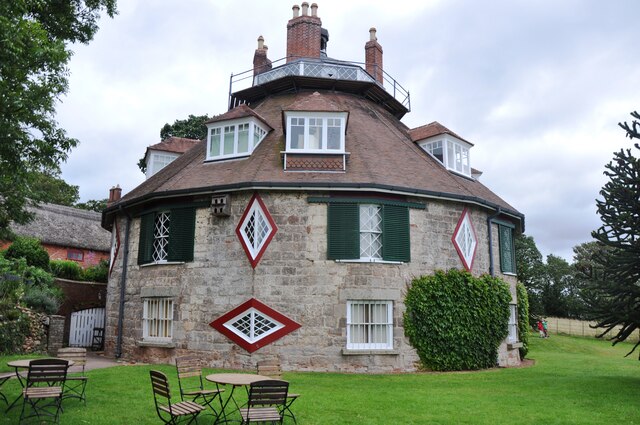
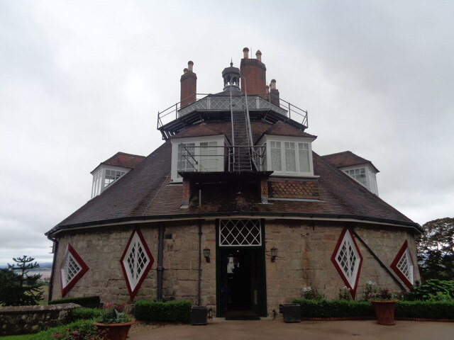
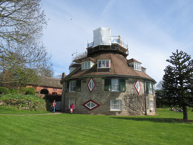
A La Ronde is a unique and remarkable heritage site located in Devon, England. This extraordinary 18th-century house was built in 1796 by Jane and Mary Parminter, two cousins who were inspired by their travels across Europe.

The most striking feature of A La Ronde is its unusual circular design, which was influenced by the architecture they encountered during their extensive European journey. The house consists of 16 sides, with each room radiating from a central octagonal hall. The interior is adorned with an array of intricate and delicate decorative elements, including shells, feathers, and mementos from their travels.

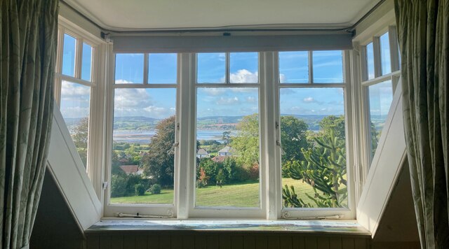
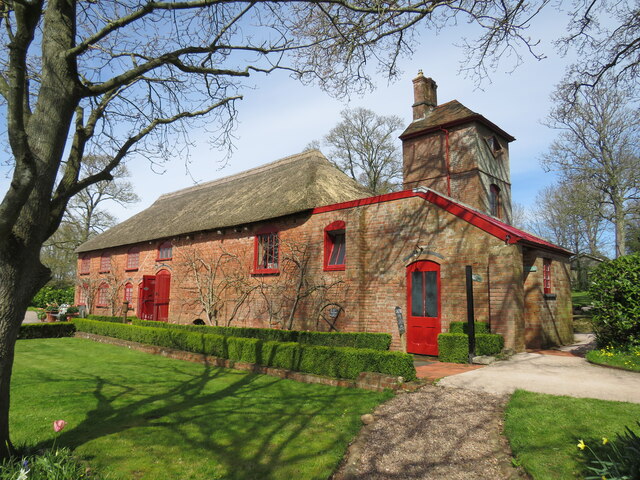
The gardens surrounding A La Ronde are equally impressive. They offer breathtaking views of the Exe Estuary and are meticulously maintained with a variety of plants, flowers, and trees. Visitors can wander through winding paths, relax in the peaceful atmosphere, and enjoy the beauty of the surrounding nature.

A La Ronde also houses a fascinating collection of objects and artifacts, each with its own unique story. From an extensive collection of miniature paintings to a shell-encrusted gallery, the house showcases the eclectic and eccentric tastes of its former owners.

Recognizing its historical and architectural significance, A La Ronde was acquired by the National Trust in 1991. Today, it serves as a popular visitor attraction, providing an insight into the lives and adventures of Jane and Mary Parminter. Whether exploring the enchanting interior, strolling through the gardens, or learning about the Parminters' fascinating journey, a visit to A La Ronde is a truly captivating experience.

If you have any feedback on the listing, please let us know in the comments section below.

A La Ronde Images

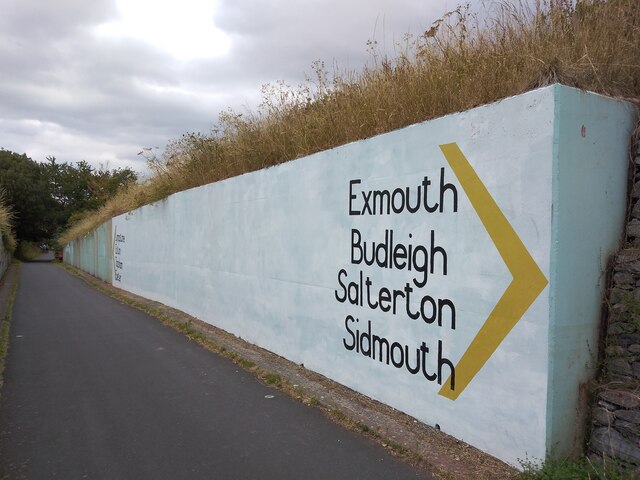
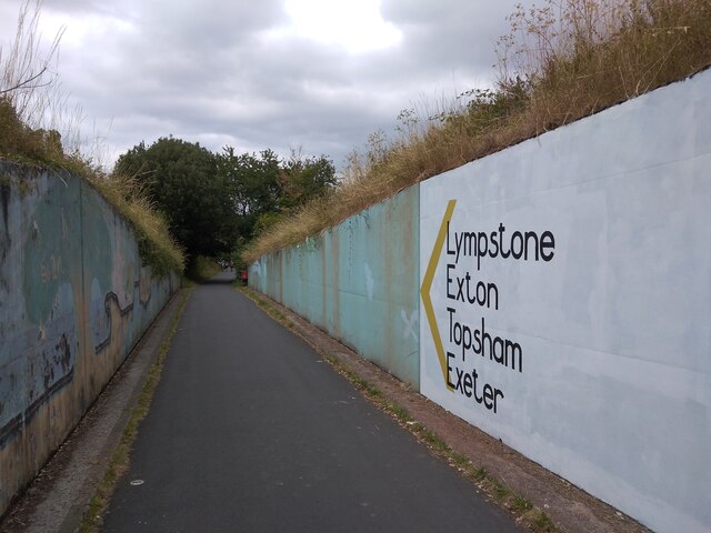
Images are sourced within 2km of 50.642/-3.41 or Grid Reference SY0083. Thanks to Geograph Open Source API. All images are credited.

A-La-Ronde House This quirky house is owned by the National Trust.
A-La-Ronde House
This quirky house is owned by the National Trust.
A La Ronde
A La Ronde
Residential Street in Exmouth A view of Carter Avenue, a residential street in Exmouth in Devon.
Residential Street in Exmouth
A view of Carter Avenue, a residential street in Exmouth in Devon.
Room with a view The view from one of the bedrooms at the National Trust property A la Ronde, near Exmouth. The view is of the River Exe estuary with Starcross in the distance.

A la Ronde is a quirky eighteenth century 16-sided house, built by two cousins, Jane and Mary Parminter and is packed to the rafters with mementos from their European grand tours.
Room with a view
The view from one of the bedrooms at the National Trust property A la Ronde, near Exmouth. The view is of the River Exe estuary with Starcross in the distance. A la Ronde is a quirky eighteenth century 16-sided house, built by two cousins, Jane and Mary Parminter and is packed to the rafters with mementos from their European grand tours.
The East Devon Way along the northern edge of Exmouth A 40 mile route that starts at Exmouth and follows the estuary of the River Exe to Lympstone and then turns east over the commons and rolling hills of the East Devon AONB via Harpford, Sidbury, Farway and Colyton to Lyme Regis. It covers a wide variety of landscapes; estuary, high open commons, woodlands and quiet river valleys. Walking is generally not difficult but the route does include some quite sharp climbs.
The East Devon Way along the northern edge of Exmouth
A 40 mile route that starts at Exmouth and follows the estuary of the River Exe to Lympstone and then turns east over the commons and rolling hills of the East Devon AONB via Harpford, Sidbury, Farway and Colyton to Lyme Regis. It covers a wide variety of landscapes; estuary, high open commons, woodlands and quiet river valleys. Walking is generally not difficult but the route does include some quite sharp climbs.
The East Devon Way on Marley Road Passing through the Hulham district of north Exmouth
The East Devon Way on Marley Road
Passing through the Hulham district of north Exmouth
Jubilee Drive, Exmouth Stop for Stagecoach bus 57 to Exeter via Exmouth
Jubilee Drive, Exmouth
Stop for Stagecoach bus 57 to Exeter via Exmouth
Marley Road joining Higher Marley Road, Exmouth Taking the East Devon Way out of Exmouth
Marley Road joining Higher Marley Road, Exmouth
Taking the East Devon Way out of Exmouth
Bystock Wood, off Higher Marley Road, Exmouth
A La Ronde This sixteen-sided cottage was built in the late eighteenth century for Jane and Mary Parminter, on their return from a Grand Tour of Europe. According to tradition, the design was inspired by their visit to the octagonal basilica of San Vitale at Ravenna.
A La Ronde
This sixteen-sided cottage was built in the late eighteenth century for Jane and Mary Parminter, on their return from a Grand Tour of Europe. According to tradition, the design was inspired by their visit to the octagonal basilica of San Vitale at Ravenna.
A la Ronde under wraps Unusual country home, cared for by the National Trust, undergoing some essential repairs.
A la Ronde under wraps
Unusual country home, cared for by the National Trust, undergoing some essential repairs.
Barn at A la Ronde More conventional design than the adjacent house!
Barn at A la Ronde
More conventional design than the adjacent house!
Foot & Cycle Path in Exmouth The foot & cycle path in Exmouth, Devon running alongside the railway with King George's playing field on the right-hand side.
Foot & Cycle Path in Exmouth
The foot & cycle path in Exmouth, Devon running alongside the railway with King George's playing field on the right-hand side.
Direction sign as art, Lympstone South of Lympstone, the Exe Estuary Way (footpath and cyclepath) runs through a cutting, with reinforced walls on each side.  These walls were decorated by children from the local school <a href="https://www.geograph.org.uk/photo/3711620">SX9983 : East Devon : Cycle Path</a>, and over time, the paints faded and attracted graffiti.  Early in 2022, part of the wall was repainted with direction arrows; as the only choice is to go north or south, the signs do not convey much information.
Direction sign as art, Lympstone
South of Lympstone, the Exe Estuary Way (footpath and cyclepath) runs through a cutting, with reinforced walls on each side. These walls were decorated by children from the local school SX9983 : East Devon : Cycle Path, and over time, the paints faded and attracted graffiti. Early in 2022, part of the wall was repainted with direction arrows; as the only choice is to go north or south, the signs do not convey much information.
Direction sign as art (2), Lympstone South of Lympstone, the Exe Estuary Way (footpath and cyclepath) runs through a cutting, with reinforced walls on each side.  These walls were decorated by children from the local school <a href="https://www.geograph.org.uk/photo/3711620">SX9983 : East Devon : Cycle Path</a>, and over time, the paints faded and attracted graffiti.  Early in 2022, part of the wall was repainted with direction arrows; as the only choice is to go north or south, the signs do not convey much information.
Direction sign as art (2), Lympstone
South of Lympstone, the Exe Estuary Way (footpath and cyclepath) runs through a cutting, with reinforced walls on each side. These walls were decorated by children from the local school SX9983 : East Devon : Cycle Path, and over time, the paints faded and attracted graffiti. Early in 2022, part of the wall was repainted with direction arrows; as the only choice is to go north or south, the signs do not convey much information.
Am OS Bench Mark Situated on the annex wall to Four Winds cottage.
Am OS Bench Mark
Situated on the annex wall to Four Winds cottage.
Smeath Cottage Bench Mark Situated low down on a side wall.
Smeath Cottage Bench Mark
Situated low down on a side wall.
An OS Bench Mark Situated at the base of the railway bridge.
Currently partially buried in ivy.
An OS Bench Mark
Situated at the base of the railway bridge. Currently partially buried in ivy.
Show me another place!

A La Ronde is located at Grid Ref: SY0083 (Lat: 50.642, Lng: -3.41)

What 3 Words

///spider.pens.grape. Near Lympstone, Devon

Nearby Locations

A-la-Ronde A La Ronde

Related Wikis

Nearby Amenities

Located within 500m of 50.642,-3.41
Speed Camera
Maxspeed: 30 mph
Lat/Long: 50.641463/-3.4117492
Courtlands Cross
Junction: yes
Lat/Long: 50.6420099/-3.4120238
Turning Circle
Lat/Long: 50.6407712/-3.4043754
Turning Circle
Lat/Long: 50.6406076/-3.4036337
Turning Circle
Lat/Long: 50.6409797/-3.4052094
Turning Circle
Lat/Long: 50.641184/-3.4073022
Turning Circle
Lat/Long: 50.6391476/-3.4068184
Turning Circle
Lat/Long: 50.6398475/-3.4078613
Turning Circle
Lat/Long: 50.6403117/-3.407415
Post Box
Check Date: 2022-03-14
Collection Times: Mo-Fr 09:00; Sa 07:00
Operator: Royal Mail
Post Box Type: pillar
Ref: EX8 160D
Royal Cypher: EIIR
Royal Cypher Wikidata: Q33102113
Source: survey
Lat/Long: 50.6399279/-3.4048796
Entrance: main
Lat/Long: 50.6417145/-3.4087053
Traffic Calming: bump
Lat/Long: 50.642353/-3.4086945
Post Office
Rivermead Avenue Post Office
Addr City: Exmouth
Addr Housenumber: 23-25
Addr Postcode: EX8 3BH
Addr Street: Rivermead Avenue
Opening Hours: Mo-Sa 05:30-19:30; Su 05:30-13:00
Ref Pol Id: 12737
Lat/Long: 50.6384246/-3.4089474
Fuel
Brand: Esso
Mapillary: 417211870342458
Operator: Esso
Survey Date: 2022-05-22
Lat/Long: 50.641723/-3.4120573
Haldon Motors
Addr Street: Exeter Road
Shop: car
Source: local knowledge
Website: https://www.haldonmotors.co.uk/
Lat/Long: 50.6418696/-3.4116865
Disused Amenity: cafe
Layer: -1
Note: cafe closed, likely permentantly, but preserving node for history incase reopns in the near future
Lat/Long: 50.6417217/-3.4088986
Toilets
Check Date: 2023-08-23
Fee: no
Lat/Long: 50.6417026/-3.4084387
Entrance: main
Lat/Long: 50.6418061/-3.4084744
Entrance: yes
Lat/Long: 50.6418154/-3.4085975
Shop: gift
Lat/Long: 50.6418274/-3.4085513
Bicycle Parking
Bicycle Parking: bollard
Capacity: 6
Check Date Capacity: 2023-09-12
Covered: no
Lat/Long: 50.6419879/-3.4081094
Barrier: cycle_barrier
Cycle Barrier: double
Lat/Long: 50.6391985/-3.4109475
Traffic Signals
Bicycle: yes
Button Operated: yes
Crossing: traffic_signals
Crossing Island: no
Crossing Ref: toucan
Kerb: lowered
Tactile Paving: yes
Traffic Signals Direction: both
Lat/Long: 50.6391939/-3.4108442
Bus Stop
Courtlands Cross
Bench: no
Bin: no
Bus: yes
Lit: yes
Naptan AtcoCode: 1100DEC10810
Naptan BusStopType: MKD
Naptan Indicator: NW-bound
Naptan NaptanCode: dvndtpjg
Naptan StopType: BCT
Naptan Street: Exmouth Road
Naptan TimingStatus: OTH
Public Transport: platform
Shelter: yes
Source: naptan
Tactile Paving: no
Validated: false
Lat/Long: 50.6423776/-3.4124125
Bus Stop
Courtlands Cross
Bench: no
Bin: no
Bus: yes
Lit: yes
Naptan AtcoCode: 1100DEC10808
Naptan BusStopType: MKD
Naptan Indicator: S-bound
Naptan NaptanCode: dvndtpjw
Naptan StopType: BCT
Naptan Street: Exeter Road
Naptan TimingStatus: OTH
Public Transport: platform
Shelter: no
Source: naptan
Tactile Paving: no
Validated: false
Lat/Long: 50.6414778/-3.4117066
Bus Stop
Littlemead Lane
Bench: no
Bin: no
Lit: no
Naptan AtcoCode: 1100DEC10994
Naptan BusStopType: MKD
Naptan Indicator: NW-bound
Naptan NaptanCode: dvndtwap
Naptan StopType: BCT
Naptan Street: Littlemead Lane
Naptan TimingStatus: OTH
Public Transport: platform
Shelter: no
Source: naptan
Validated: false
Lat/Long: 50.6388634/-3.4077675
Bus Stop
Littlemead Lane
Bench: no
Bin: no
Lit: no
Naptan AtcoCode: 1100DEC10995
Naptan BusStopType: MKD
Naptan Indicator: SE-bound
Naptan NaptanCode: dvndtwaw
Naptan StopType: BCT
Naptan Street: Littlemead Lane
Naptan TimingStatus: OTH
Public Transport: platform
Shelter: no
Source: naptan
Validated: false
Lat/Long: 50.6388645/-3.4076827
Bus Stop
Rivermead Avenue
Bench: no
Bin: no
Bus: yes
Lit: yes
Naptan AtcoCode: 1100DEC10807
Naptan BusStopType: MKD
Naptan Indicator: opp
Naptan NaptanCode: dvndtpmw
Naptan StopType: BCT
Naptan Street: Exeter Road
Naptan TimingStatus: OTH
Public Transport: platform
Shelter: yes
Source: naptan
Tactile Paving: no
Validated: false
Lat/Long: 50.6385843/-3.4108696
Bus Stop
Rivermead Avenue
Bench: yes
Bin: no
Bus: yes
Lit: yes
Naptan AtcoCode: 1100DEC10806
Naptan BusStopType: MKD
Naptan Indicator: S-bound
Naptan NaptanCode: dvndtptg
Naptan StopType: BCT
Naptan Street: Exeter Road
Naptan TimingStatus: OTH
Public Transport: platform
Shelter: yes
Source: naptan
Tactile Paving: no
Validated: false
Lat/Long: 50.6376363/-3.4103329
Bus Stop
Post Office
Bench: no
Bin: no
Bus: yes
Lit: no
Naptan AtcoCode: 1100DEC10985
Naptan BusStopType: MKD
Naptan Indicator: opp
Naptan NaptanCode: dvndtptw
Naptan StopType: BCT
Naptan Street: Rivermead Avenue
Naptan TimingStatus: OTH
Public Transport: platform
Shelter: no
Source: naptan
Validated: false
Lat/Long: 50.6381103/-3.4098097
Bus Stop
Post Office
Bus: yes
Naptan AtcoCode: 1100DEC10984
Naptan BusStopType: MKD
Naptan Indicator: E-bound
Naptan NaptanCode: dvndtpwg
Naptan StopType: BCT
Naptan Street: Rivermead Avenue
Naptan TimingStatus: OTH
Public Transport: platform
Source: naptan
Validated: false
Lat/Long: 50.6383171/-3.4090663
Bus Stop
Mount Pleasant Avenue
Bench: no
Bin: no
Lit: yes
Naptan AtcoCode: 1100DEZ05254
Naptan BusStopType: MKD
Naptan Indicator: SE-bound
Naptan NaptanCode: dvndtwgt
Naptan StopType: BCT
Naptan Street: Mount Pleasant Avenue
Naptan TimingStatus: OTH
Public Transport: platform
Shelter: no
Source: naptan
Validated: false
Lat/Long: 50.6403624/-3.4060809
Bus Stop
Mount Pleasant Avenue
Bench: no
Bin: no
Lit: no
Naptan AtcoCode: 1100DEA09065
Naptan BusStopType: MKD
Naptan Indicator: SW-bound
Naptan NaptanCode: dvngjdtg
Naptan StopType: BCT
Naptan Street: Mount Pleasant Avenue
Naptan TimingStatus: OTH
Public Transport: platform
Shelter: no
Source: naptan
Validated: false
Lat/Long: 50.6397057/-3.4072835
Bus Stop
Thorpe Avenue
Naptan AtcoCode: 1100DEC10997
Naptan BusStopType: MKD
Naptan Indicator: NW-bound
Naptan NaptanCode: dvndtwmg
Naptan StopType: BCT
Naptan Street: Mount Pleasant Avenue
Naptan TimingStatus: OTH
Public Transport: platform
Source: naptan
Validated: false
Lat/Long: 50.6400848/-3.4051712
Barrier: cycle_barrier
Cycle Barrier: double
Lat/Long: 50.6392542/-3.4107468
Generator Method: photovoltaic
Generator Output Electricity: yes
Generator Source: solar
Generator Type: solar_photovoltaic_panel
Location: roof
Power: generator
Lat/Long: 50.6400264/-3.409668
Generator Method: photovoltaic
Generator Output Electricity: yes
Generator Source: solar
Generator Type: solar_photovoltaic_panel
Location: roof
Power: generator
Lat/Long: 50.640848/-3.410875
Generator Method: photovoltaic
Generator Output Electricity: yes
Generator Source: solar
Generator Type: solar_photovoltaic_panel
Location: roof
Power: generator
Lat/Long: 50.6411933/-3.4150539
Generator Method: photovoltaic
Generator Output Electricity: yes
Generator Source: solar
Generator Type: solar_photovoltaic_panel
Location: roof
Power: generator
Lat/Long: 50.6376789/-3.4087293
Generator Method: photovoltaic
Generator Output Electricity: yes
Generator Source: solar
Generator Type: solar_photovoltaic_panel
Location: roof
Power: generator
Lat/Long: 50.6376296/-3.4092281
Generator Method: photovoltaic
Generator Output Electricity: yes
Generator Source: solar
Generator Type: solar_photovoltaic_panel
Location: roof
Power: generator
Lat/Long: 50.6400394/-3.408644
Generator Method: photovoltaic
Generator Output Electricity: yes
Generator Source: solar
Generator Type: solar_photovoltaic_panel
Location: roof
Power: generator
Lat/Long: 50.6407462/-3.4075134
Generator Method: photovoltaic
Generator Output Electricity: yes
Generator Source: solar
Generator Type: solar_photovoltaic_panel
Location: roof
Power: generator
Lat/Long: 50.6406312/-3.4043384
Generator Method: photovoltaic
Generator Output Electricity: yes
Generator Source: solar
Generator Type: solar_photovoltaic_panel
Location: roof
Power: generator
Lat/Long: 50.6406487/-3.4042832
Generator Method: photovoltaic
Generator Output Electricity: yes
Generator Source: solar
Generator Type: solar_photovoltaic_panel
Location: roof
Power: generator
Lat/Long: 50.6407745/-3.4099214
Generator Method: photovoltaic
Generator Output Electricity: yes
Generator Source: solar
Generator Type: solar_photovoltaic_panel
Location: roof
Power: generator
Lat/Long: 50.6409074/-3.4101364
Generator Method: photovoltaic
Generator Output Electricity: yes
Generator Source: solar
Generator Type: solar_photovoltaic_panel
Location: roof
Power: generator
Lat/Long: 50.6410215/-3.4110203
Generator Method: photovoltaic
Generator Output Electricity: yes
Generator Source: solar
Generator Type: solar_photovoltaic_panel
Location: roof
Power: generator
Lat/Long: 50.6410738/-3.4110753
Generator Method: photovoltaic
Generator Output Electricity: yes
Generator Source: solar
Generator Type: solar_photovoltaic_panel
Location: roof
Power: generator
Lat/Long: 50.6415568/-3.4140762
Generator Method: photovoltaic
Generator Output Electricity: yes
Generator Source: solar
Generator Type: solar_photovoltaic_panel
Location: roof
Power: generator
Lat/Long: 50.6415777/-3.4141325
Generator Method: photovoltaic
Generator Output Electricity: yes
Generator Source: solar
Generator Type: solar_photovoltaic_panel
Location: roof
Power: generator
Lat/Long: 50.6412656/-3.4147704
Generator Method: photovoltaic
Generator Output Electricity: yes
Generator Source: solar
Generator Type: solar_photovoltaic_panel
Location: roof
Power: generator
Lat/Long: 50.6420786/-3.4128781
Generator Method: photovoltaic
Generator Output Electricity: yes
Generator Source: solar
Generator Type: solar_photovoltaic_panel
Location: roof
Power: generator
Lat/Long: 50.6420828/-3.4129787
Generator Method: photovoltaic
Generator Output Electricity: yes
Generator Source: solar
Generator Type: solar_photovoltaic_panel
Location: roof
Power: generator
Lat/Long: 50.6420939/-3.4127574
Generator Method: photovoltaic
Generator Output Electricity: yes
Generator Source: solar
Generator Type: solar_photovoltaic_panel
Location: roof
Power: generator
Lat/Long: 50.6403567/-3.4100826
Generator Method: photovoltaic
Generator Output Electricity: yes
Generator Source: solar
Generator Type: solar_photovoltaic_panel
Location: roof
Power: generator
Lat/Long: 50.6405371/-3.4097124
Generator Method: photovoltaic
Generator Output Electricity: yes
Generator Source: solar
Generator Type: solar_photovoltaic_panel
Location: roof
Power: generator
Lat/Long: 50.6405625/-3.4097929
Generator Method: photovoltaic
Generator Output Electricity: yes
Generator Source: solar
Generator Type: solar_photovoltaic_panel
Location: roof
Power: generator
Lat/Long: 50.6406489/-3.4097956
Generator Method: photovoltaic
Generator Output Electricity: yes
Generator Source: solar
Generator Type: solar_photovoltaic_panel
Location: roof
Power: generator
Lat/Long: 50.6412565/-3.4105352
Generator Method: photovoltaic
Generator Output Electricity: yes
Generator Source: solar
Generator Type: solar_photovoltaic_panel
Location: roof
Power: generator
Lat/Long: 50.6413046/-3.4105949
Generator Method: photovoltaic
Generator Output Electricity: yes
Generator Source: solar
Generator Type: solar_photovoltaic_panel
Location: roof
Power: generator
Lat/Long: 50.6419667/-3.4112883
Generator Method: photovoltaic
Generator Output Electricity: yes
Generator Source: solar
Generator Type: solar_photovoltaic_panel
Location: roof
Power: generator
Lat/Long: 50.6419446/-3.4114157
Generator Method: photovoltaic
Generator Output Electricity: yes
Generator Source: solar
Generator Type: solar_photovoltaic_panel
Location: roof
Power: generator
Lat/Long: 50.6399602/-3.4072958
Generator Method: photovoltaic
Generator Output Electricity: yes
Generator Source: solar
Generator Type: solar_photovoltaic_panel
Location: roof
Power: generator
Lat/Long: 50.6384485/-3.4075646
Generator Method: photovoltaic
Generator Output Electricity: yes
Generator Source: solar
Generator Type: solar_photovoltaic_panel
Location: roof
Power: generator
Lat/Long: 50.6384408/-3.4088976
Generator Method: photovoltaic
Generator Output Electricity: yes
Generator Source: solar
Generator Type: solar_photovoltaic_panel
Location: roof
Power: generator
Lat/Long: 50.644442/-3.4107966
Traffic Calming: bump
Lat/Long: 50.6423062/-3.4084767
Bench
Backrest: yes
Colour: green
Material: wood
Lat/Long: 50.6420798/-3.4118939
Post Box
Check Date: 2022-03-14
Collection Times: Mo-Fr 09:00; Sa 07:00
Operator: Royal Mail
Post Box Type: wall
Ref: EX8 15D
Royal Cypher: GR
Royal Cypher Wikidata: Q33102273
Source: survey
Lat/Long: 50.6420985/-3.4119368
Post Box
Check Date: 2022-03-14
Collection Times: Mo-Fr 17:15; Sa 12:45
Operator: Royal Mail
Post Box Type: pillar
Ref: EX8 604
Royal Cypher: EIIR
Royal Cypher Wikidata: Q33102113
Source: survey
Lat/Long: 50.6383685/-3.4088717
Courtlands Cross
Ele: 51.663
Man Made: survey_point
Material: concrete
Ref: ST11/T99
Survey Point Purpose: both
Survey Point Structure: block
Lat/Long: 50.6423746/-3.412253
Courtlands
Place: locality
Lat/Long: 50.64106/-3.4164017
Waste Basket
Survey Date: 2023-01-29
Lat/Long: 50.6418066/-3.4116637
Parcel Locker
Parcel Mail In: yes
Parcel Pickup: yes
Survey Date: 2023-01-29
Lat/Long: 50.6417781/-3.4121145
Bench
Backrest: no
Material: wood
Lat/Long: 50.6422822/-3.4094699
Bench
Backrest: no
Material: wood
Lat/Long: 50.6421359/-3.4105669
Bench
Backrest: no
Material: wood
Lat/Long: 50.6419262/-3.4109766
Bench
Backrest: no
Material: wood
Lat/Long: 50.640393/-3.4089841
Entrance: exit
Lat/Long: 50.6417627/-3.4088014
Artwork Type: statue
Tourism: artwork
Lat/Long: 50.6416337/-3.408456
Man Made: obelisk
Material: stone
Obelisk Size: medium
Start Date: 1996
Lat/Long: 50.6412101/-3.4080315
Bench
Backrest: yes
Colour: white
Material: metal
Lat/Long: 50.6413926/-3.408165
Bench
Backrest: yes
Colour: white
Material: metal
Lat/Long: 50.6415197/-3.4082917
Operator: National Trust
Shop: ticket
Lat/Long: 50.6419445/-3.408055
Traffic Calming: bump
Lat/Long: 50.6423351/-3.4090206
The data included in this document is from www.openstreetmap.org. The data is made available under ODbL.

Have you been to A La Ronde?

Leave your review of A La Ronde below (or comments, questions and feedback).