Worsbrough Village

Settlement in Yorkshire

England

Worsbrough Village

Rockley Engine House
Rockley Engine House Credit: Dave Pickersgill

Worsbrough Village is a charming settlement located in the metropolitan borough of Barnsley, South Yorkshire, England. Situated just 5 miles south of Barnsley town center, the village is nestled within the picturesque countryside, offering residents and visitors a tranquil escape from the hustle and bustle of urban life.

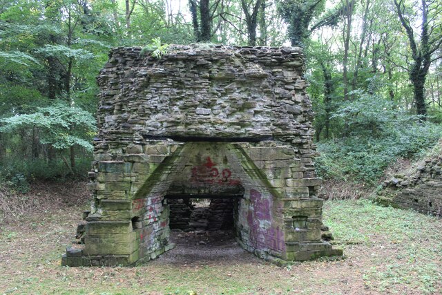
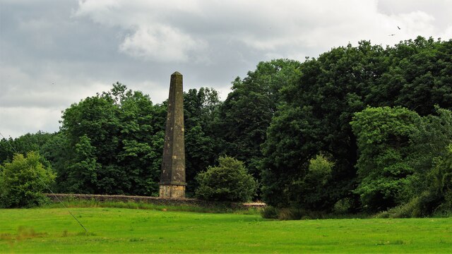
The village is renowned for its rich historical heritage. One of the focal points is Worsbrough Mill, a 17th-century working watermill that has been beautifully preserved and is now a popular tourist attraction. Visitors can witness the traditional milling process and explore the adjacent country park, which provides scenic walking trails along the banks of the River Dove.

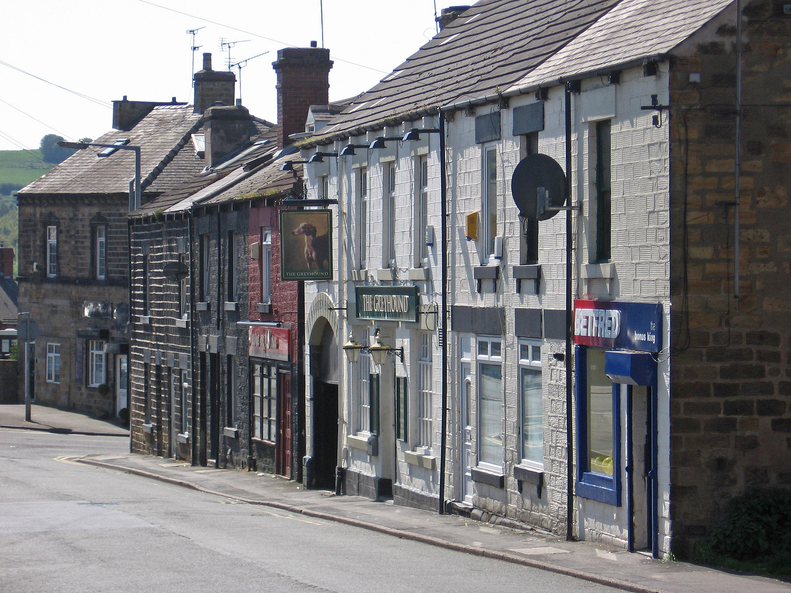
The village itself boasts an array of quaint stone-built houses, many of which date back to the 18th and 19th centuries, adding to the area's charm and character. Worsbrough Village also features several local amenities, including a primary school, a village hall, and a number of traditional pubs that offer a warm welcome to locals and visitors alike.

For nature enthusiasts, the nearby Worsbrough Reservoir offers opportunities for fishing and birdwatching, while the Trans Pennine Trail, a long-distance footpath, passes through the village, attracting walkers and cyclists who enjoy the scenic route.

With its rich history, idyllic countryside setting, and various attractions, Worsbrough Village is a hidden gem in Yorkshire, offering a delightful blend of heritage, natural beauty, and community spirit.

If you have any feedback on the listing, please let us know in the comments section below.

Worsbrough Village Images

Images are sourced within 2km of 53.519474/-1.4743205 or Grid Reference SE3402. Thanks to Geograph Open Source API. All images are credited.

Rockley Engine House
Rockley Forge
Rockley Forge
Footbridge, Worsbrough Country Park
Queen Anne's Obelisk On the Wentworth Castle Estate
Queen Anne's Obelisk
On the Wentworth Castle Estate
Old milepost This milepost at the busy traffic lights cross-roads on the A61 out of Barnsley was painted in 2016.  It is from the Wakefield to Sheffield turnpike first enacted in 1758.   There are only 2 posts remaining north of Barnsley and 5 (including one in the park at Firth Park) on the way to Sheffield.    The two north of Barnsley are a different style to the ones on the Sheffield route.   A visit to clean the post and redo the legends is needed.  This post is Grade II listed 1192299.
Old milepost
This milepost at the busy traffic lights cross-roads on the A61 out of Barnsley was painted in 2016. It is from the Wakefield to Sheffield turnpike first enacted in 1758. There are only 2 posts remaining north of Barnsley and 5 (including one in the park at Firth Park) on the way to Sheffield. The two north of Barnsley are a different style to the ones on the Sheffield route. A visit to clean the post and redo the legends is needed. This post is Grade II listed 1192299.
Worsbrough Corn Mill Now a museum
Worsbrough Corn Mill
Now a museum
Old milestone Since this milestone was last photographed, the entrance into the Wentworth Castle estate on Rockley Lane leading to Queen Anne's Obelisk has been tarmacked.   Fortunately the legend on the milestone, 1/Mile, is still visible and the tarmac will keep the weeds at bay.  Wentworth Castle was built between 1711-1764 for Willian Wentworth, the Earl of Strafford.
Old milestone
Since this milestone was last photographed, the entrance into the Wentworth Castle estate on Rockley Lane leading to Queen Anne's Obelisk has been tarmacked. Fortunately the legend on the milestone, 1/Mile, is still visible and the tarmac will keep the weeds at bay. Wentworth Castle was built between 1711-1764 for Willian Wentworth, the Earl of Strafford.
Queen Anne's Obelisk The Wenworth Estate folly appears to be in the garden of the lodge in this view
Queen Anne's Obelisk
The Wenworth Estate folly appears to be in the garden of the lodge in this view
Stone tower on Hound Hill Lane It dates from 1642 and was created under the instructions of Richard Elmhirst, the owner of the adjacent property. He sided with royalists during The English Civil War.
Stone tower on Hound Hill Lane
It dates from 1642 and was created under the instructions of Richard Elmhirst, the owner of the adjacent property. He sided with royalists during The English Civil War.
Outbuildings at Houndhill Houndhill is a substantial Grade II listed Tudor farmhouse (part timber-framed) which dates from the late sixteenth century. Unfortunately, the house itself is not visible from Hound Hill Lane being set back from the road.
Outbuildings at Houndhill
Houndhill is a substantial Grade II listed Tudor farmhouse (part timber-framed) which dates from the late sixteenth century. Unfortunately, the house itself is not visible from Hound Hill Lane being set back from the road.
Treelands Cottage at Brough Green Though it looks very peaceful, it is in fact very close to the M1 motorway with its constantly roaring traffic noise.
Treelands Cottage at Brough Green
Though it looks very peaceful, it is in fact very close to the M1 motorway with its constantly roaring traffic noise.
Wooden sculpture A wooden sculpture adjacent to Worsbrough Reservoir.
Wooden sculpture
A wooden sculpture adjacent to Worsbrough Reservoir.
Sculptured bench A sculptured bench adjacent to Worsbrough Reservoir.
Sculptured bench
A sculptured bench adjacent to Worsbrough Reservoir.
Worsbrough Reservoir With Wentworth Castle in the distance
Worsbrough Reservoir
With Wentworth Castle in the distance
Fields and new houses, Upper Hoyland View from the foot of the Hoyland Lowe Stand folly.
Fields and new houses, Upper Hoyland
View from the foot of the Hoyland Lowe Stand folly.
Houses on Park Road
Houses on Park Road
Houses on Sheffield Road
Show me another place!

Worsbrough Village is located at Grid Ref: SE3402 (Lat: 53.519474, Lng: -1.4743205)

Division: West Riding

Unitary Authority: Barnsley

Police Authority: South Yorkshire

What 3 Words

///fully.beans.media. Near Birdwell, South Yorkshire

Related Wikis

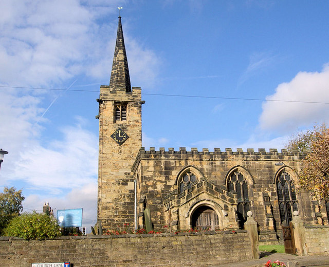
Church of St Mary, Worsbrough

The Church of St. Mary is the parish church in the village of Worsbrough in South Yorkshire, England. It is a Church of England church in the Diocese of...

Worsbrough

Worsbrough is an area about two miles south of Barnsley in the metropolitan borough of Barnsley, South Yorkshire, England. Before 1974, Worsbrough had...
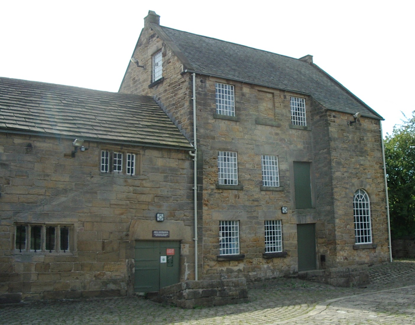
Worsbrough Mill

Worsbrough Mill, also known as Worsbrough Corn Mill and Worsbrough Mill Farm is a complex of buildings including a seventeenth-century water-powered mill...

Worsbrough Bridge Athletic F.C.

Worsbrough Bridge Athletic Football Club is a football club based in Worsbrough, Barnsley, South Yorkshire, England. They are currently members of the...

Related Videos

Hauck Travel Cot Dream N Play Unboxing Set UP and Review #baby

In this video we show you the unboxing, set up and how to dismantle the Hauck Dream N Play Travel cot. The baby travel cot is ...

Cannon Hall Barnsley Stately home walking tour sarahs uk graveyard english history

I made it to Cannon Hall and wanted to show you around. I used the new camera, think it looks better sarahs uk graveyard.

Nearby Amenities

Located within 500m of 53.519474,-1.4743205
Bus Stop
Worsbrough Road/Priory Close
Bus: yes
Naptan AtcoCode: 370050480
Naptan Bearing: NE
Naptan CommonName: Worsbrough Road/Priory Close
Naptan Indicator: 50480
Naptan Landmark: CHURCH
Naptan PlusbusZoneRef: ROTHCEN
Naptan Street: Worsbrough Road
Naptan Verified: no
Public Transport: platform
Source: naptan_import
Lat/Long: 53.5196656/-1.4741305
Bus Stop
Sheffield Road/Shaw Bank Wood
Bus: yes
Naptan AtcoCode: 370050481
Naptan Bearing: NE
Naptan CommonName: Sheffield Road/Shaw Bank Wood
Naptan Indicator: 50481
Naptan Landmark: SHAW BANK WOOD
Naptan PlusbusZoneRef: ROTHCEN
Naptan Street: Sheffield Road
Naptan Verified: no
Public Transport: platform
Source: naptan_import
Lat/Long: 53.5199594/-1.4796472
Bus Stop
Worsbrough Road/St Marys School
Alt Name: Worsbrough Road/St Marys School
Naptan AltCommonName: Worsbrough Road/St Marys School
Naptan AtcoCode: 370050486
Naptan Bearing: NE
Naptan CommonName: Worsbrough Road/St Marys School
Naptan Indicator: 50486
Naptan Landmark: OPPOSITE ST MARYS SCHOOL
Naptan PlusbusZoneRef: ROTHCEN
Naptan Street: Worsbrough Road
Naptan Verified: no
Source: naptan_import
Lat/Long: 53.5159988/-1.4763175
Bus Stop
Worsbrough Road/St Marys School
Alt Name: Worsbrough Road/St Marys School
Naptan AltCommonName: Worsbrough Road/St Marys School
Naptan AtcoCode: 370050487
Naptan Bearing: SW
Naptan CommonName: Worsbrough Road/St Marys School
Naptan Indicator: 50487
Naptan Landmark: OUTSIDE ST MARYS SCHOOL/GRAVE
Naptan PlusbusZoneRef: ROTHCEN
Naptan Street: Worsbrough Road
Naptan Verified: no
Source: naptan_import
Lat/Long: 53.5165803/-1.475692
Bus Stop
Worsbrough Road/St Marys Church
Alt Name: Worsbrough Road/St Marys Church
Bus: yes
Naptan AltCommonName: Worsbrough Road/St Marys Church
Naptan AtcoCode: 370050488
Naptan Bearing: SW
Naptan CommonName: Worsbrough Road/St Marys Church
Naptan Indicator: 50488
Naptan Landmark: CHURCH
Naptan PlusbusZoneRef: ROTHCEN
Naptan Street: Worsbrough Road
Naptan Verified: no
Public Transport: platform
Source: naptan_import
Lat/Long: 53.5187222/-1.4742327
Bus Stop
Worsbrough Road/Hall Close
Bus: yes
Naptan AtcoCode: 370050664
Naptan Bearing: NE
Naptan CommonName: Worsbrough Road/Hall Close
Naptan Indicator: 50664
Naptan Landmark: WORSBROUGH HALL
Naptan PlusbusZoneRef: ROTHCEN
Naptan Street: Worsbrough Road
Naptan Verified: no
Public Transport: platform
Source: naptan_import
Lat/Long: 53.5206551/-1.4722631
Bus Stop
Sheffield Road/Shaw Bank Wood
Bus: yes
Naptan AtcoCode: 370051115
Naptan Bearing: SW
Naptan CommonName: Sheffield Road/Shaw Bank Wood
Naptan Indicator: 51115
Naptan Landmark: OPP. SHAW BANK WOOD
Naptan PlusbusZoneRef: ROTHCEN
Naptan Street: Sheffield Road
Naptan Verified: no
Public Transport: platform
Source: naptan_import
Lat/Long: 53.5201552/-1.4792074
Worsbrough Road/Hall Close
Naptan AtcoCode: 370055638
Naptan Bearing: SW
Naptan BusStopType: CUS
Naptan CommonName: Worsbrough Road/Hall Close
Naptan Indicator: 55638
Naptan Landmark: WORSBROUGH HALL
Naptan PlusbusZoneRef: ROTHCEN
Naptan Street: Worsbrough Road
Naptan Verified: no
Source: naptan_import
Lat/Long: 53.5205917/-1.4721583
Turning Circle
Lat/Long: 53.5185584/-1.472042
Power: pole
Lat/Long: 53.5208164/-1.4684649
Power: pole
Lat/Long: 53.5215381/-1.4683092
Power: pole
Lat/Long: 53.5201069/-1.4669449
Pub
Edmunds Arms
Name En: Edmunds Arms
Lat/Long: 53.5191938/-1.4749246
Marker: aerial
Lat/Long: 53.5211919/-1.4763959
Marker: aerial
Lat/Long: 53.5226389/-1.4725985
Post Box
Collection Times: Mo-Fr 09:00; Sa 07:00
Post Box Type: wall
Ref: S70 127
Royal Cypher: EIIR
Royal Cypher Wikidata: Q33102113
Lat/Long: 53.5194279/-1.4744327
Barrier: stile
Lat/Long: 53.5200123/-1.4793179
Barrier: stile
Lat/Long: 53.519506/-1.4774967
Marker: aerial
Lat/Long: 53.5190277/-1.4793563
Barrier: stile
Lat/Long: 53.5200307/-1.4795801
Marker: aerial
Lat/Long: 53.5205262/-1.4772948
Parking
Lat/Long: 53.5217084/-1.4704595
Defibrillator
Access: yes
Defibrillator Location: Phone outside wall facing the road
Emergency: defibrillator
Indoor: no
Lat/Long: 53.5193883/-1.4743097
The data included in this document is from www.openstreetmap.org. The data is made available under ODbL.

Have you been to Worsbrough Village?

Leave your review of Worsbrough Village below (or comments, questions and feedback).