Martin

Settlement in Lincolnshire North Kesteven

England

Martin

Holy Trinity church, Martin The door has changed colour in the last 10 years, <a href="https://www.geograph.org.uk/photo/3381003">TF1259 : Holy Trinity Church, Martin</a> but still locked tight and unwelcoming.
Holy Trinity church, Martin Credit: Julian P Guffogg

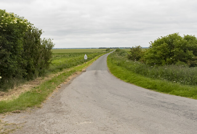
Martin is a small village located in the county of Lincolnshire, in the east of England. Situated about 10 miles south of the city of Lincoln, Martin is nestled within the picturesque countryside, surrounded by fields and farmland.

The village has a long history, dating back to the Roman times, evidenced by the discovery of Roman coins and artifacts in the area. Today, Martin retains its quaint and traditional charm, with a population of around 400 residents.

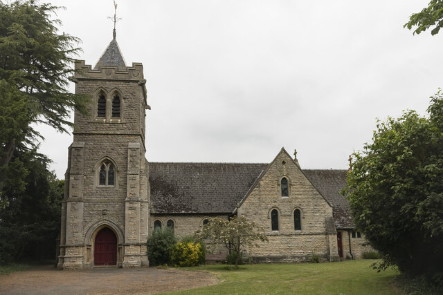
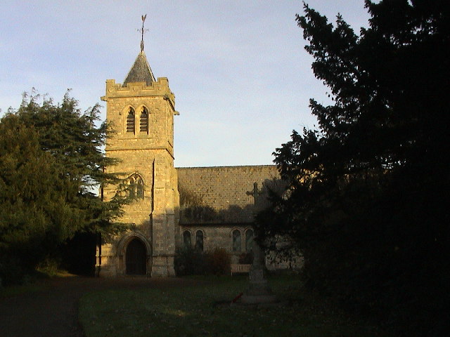
The heart of Martin is its village green, flanked by historic cottages and the Church of St. Michael and All Angels. This Grade I listed church boasts a striking medieval tower and is renowned for its beautiful stained glass windows. The village green also serves as a focal point for community events and gatherings, such as the annual summer fete.

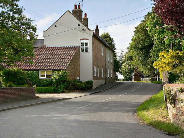
Despite its small size, the village offers several amenities for its residents. These include a primary school, a village hall, and a local pub, providing a place for socializing and community engagement.

Surrounded by scenic countryside, Martin is a popular destination for nature lovers and outdoor enthusiasts. The village is dotted with footpaths and bridleways, offering opportunities for walking, cycling, and horse riding. Additionally, the nearby Martin Moor nature reserve provides a haven for wildlife and birdwatching.

Overall, Martin, Lincolnshire, is a charming and historic village, offering a peaceful and idyllic retreat for its residents and visitors alike.

If you have any feedback on the listing, please let us know in the comments section below.

Martin Images

Images are sourced within 2km of 53.127058/-0.3276118 or Grid Reference TF1260. Thanks to Geograph Open Source API. All images are credited.

Holy Trinity church, Martin The door has changed colour in the last 10 years, <a href="https://www.geograph.org.uk/photo/3381003">TF1259 : Holy Trinity Church, Martin</a> but still locked tight and unwelcoming.
Holy Trinity church, Martin
The door has changed colour in the last 10 years, TF1259 : Holy Trinity Church, Martin but still locked tight and unwelcoming.
Disused RAF Metheringham airfield: aerial 2022
Martin North Drove Heading in the direction of Martin Dales.
Martin North Drove
Heading in the direction of Martin Dales.
Blankney Drove Looking towards Carr Dyke Farm.
Blankney Drove
Looking towards Carr Dyke Farm.
Blankney Fen
Blankney Fen
Metheringham Airfield Visitor Centre
Timberland Fen
Timberland Fen
Roadside
Roadside
Timberland The Post Office
Timberland
The Post Office
Timberland The Penny Farthing <span class="nowrap"><a title="http://www.martintimberland.co.uk/timberland/penny/penny.php" rel="nofollow ugc noopener" href="http://www.martintimberland.co.uk/timberland/penny/penny.php">Link</a><img style="margin-left:2px;" alt="External link" title="External link - shift click to open in new window" src="https://s1.geograph.org.uk/img/external.png" width="10" height="10"/></span>
Timberland
The Penny Farthing LinkExternal link
Martin Holy Trinity Church
Martin
Holy Trinity Church
Car Dyke Looking northwest. The distant culvert is a few metres into TF1260.
Car Dyke
Looking northwest. The distant culvert is a few metres into TF1260.
The western edge of Martin village The yellow panels of the speed restriction signs almost blend into the yellow rape.
The western edge of Martin village
The yellow panels of the speed restriction signs almost blend into the yellow rape.
Houghton House, Timberland ,Lincoln Formerly known as the Houghton Arms this used to be one of Timberlands village pubs
Houghton House, Timberland ,Lincoln
Formerly known as the Houghton Arms this used to be one of Timberlands village pubs
St.Andrew's church Early 13th century tower and later medieval church extensively restored by Goddard in 1887
St.Andrew's church
Early 13th century tower and later medieval church extensively restored by Goddard in 1887
St.Andrew's church tower Early 13th century Transitional / Early English tower to St.Andrew's church with bold buttresses
St.Andrew's church tower
Early 13th century Transitional / Early English tower to St.Andrew's church with bold buttresses
Timberland War Memorial On a buttress of St.Andrew's church tower <a title="https://www.geograph.org.uk/photo/695028" href="https://www.geograph.org.uk/photo/695028">Link</a>
Timberland War Memorial
On a buttress of St.Andrew's church tower Link
Memorial to Rev.Wheat To the Glory of God and in loving memory of
Christopher George Wheat
Priest
For 28 years vicar of this parish 1878 – 1901
Passed away December 4th 1908 aged 69
Rest eternal grant unto him, O Lord
And may light perpetual shine upon him
Memorial to Rev.Wheat
To the Glory of God and in loving memory of Christopher George Wheat Priest For 28 years vicar of this parish 1878 – 1901 Passed away December 4th 1908 aged 69 Rest eternal grant unto him, O Lord And may light perpetual shine upon him
Show me another place!

Martin is located at Grid Ref: TF1260 (Lat: 53.127058, Lng: -0.3276118)

Division: Parts of Kesteven

Administrative County: Lincolnshire

District: North Kesteven

Police Authority: Lincolnshire

What 3 Words

///telephone.scarecrow.duke. Near Metheringham, Lincolnshire

Nearby Locations

Martin

Related Wikis

Martin, North Kesteven

Martin is a small village and civil parish in the North Kesteven district of Lincolnshire, England. The population at the 2011 census was 866. It lies...

Metheringham Lass

The Metheringham Lass is the name given to an apparition which has been reported at RAF Metheringham. Reports have stated that the woman, wearing a jacket...

RAF Metheringham

Royal Air Force Metheringham or more simply RAF Metheringham is a former Royal Air Force station situated between the villages of Metheringham and Martin...

Timberland, Lincolnshire

Timberland is a village in the North Kesteven district of Lincolnshire, England. The population of the civil parish (including Thorpe Tilney) at the 2011...

Nearby Amenities

Located within 500m of 53.127058,-0.3276118
Source: OS_OpenData _StreetView
Lat/Long: 53.1245078/-0.3226988
Source: OS_OpenData _StreetView
Lat/Long: 53.124478/-0.3237755
Source: OS_OpenData _StreetView
Lat/Long: 53.1244562/-0.3247204
Source: OS_OpenData _StreetView
Lat/Long: 53.1248763/-0.3264173
Source: OS_OpenData _StreetView
Lat/Long: 53.1250064/-0.3284005
Source: OS_OpenData _StreetView
Lat/Long: 53.1249602/-0.3293578
Source: OS_OpenData _StreetView
Lat/Long: 53.1247091/-0.3309511
Source: OS_OpenData _StreetView
Lat/Long: 53.1244866/-0.333235
Martin
Is In: Lincolnshire, England, UK
Old Name: Merton
Place: village
Source: Bing
Lat/Long: 53.1253109/-0.3254251
Source: OS_OpenData _StreetView
Lat/Long: 53.1249627/-0.3271255
Bus Stop
Mill Lane
Naptan AtcoCode: 270002701031
Naptan Bearing: E
Naptan CommonName: Mill Lane
Naptan Indicator: adj
Naptan Landmark: Mill Lane
Naptan NaptanCode: linadtgd
Naptan Street: High Street
Naptan Verified: no
Source: naptan_import
Lat/Long: 53.1245522/-0.3234128
Bus Stop
Mill Lane
Naptan AtcoCode: 270002701032
Naptan Bearing: W
Naptan CommonName: Mill Lane
Naptan Indicator: opp
Naptan Landmark: Mill Lane
Naptan NaptanCode: linadpjp
Naptan Street: High Street
Naptan Verified: no
Source: naptan_import
Lat/Long: 53.1244622/-0.3227736
Bus Stop
Wyatt Close
Naptan AtcoCode: 2700LMC05224
Naptan Bearing: N
Naptan CommonName: Wyatt Close
Naptan Indicator: adj
Naptan Landmark: Wyatt Close
Naptan NaptanCode: lindtamw
Naptan Street: Timberland Road
Naptan Verified: no
Source: naptan_import
Lat/Long: 53.1245261/-0.3273146
Bus Stop
Wyatt Close
Naptan AtcoCode: 2700LMCC1188
Naptan Bearing: S
Naptan CommonName: Wyatt Close
Naptan Indicator: opp
Naptan Landmark: Wyatt Close
Naptan NaptanCode: linajgam
Naptan Street: Timberland Road
Naptan Verified: no
Source: naptan_import
Lat/Long: 53.1246319/-0.3271611
Power: pole
Lat/Long: 53.1287845/-0.3229768
Power: pole
Lat/Long: 53.1279581/-0.3227877
Power: pole
Lat/Long: 53.1257322/-0.3222017
Power: pole
Lat/Long: 53.1264831/-0.3224042
Power: pole
Lat/Long: 53.127229/-0.3226134
Power: pole
Lat/Long: 53.1250723/-0.322081
Power: pole
Lat/Long: 53.1302104/-0.3232223
Manor Farm
Place: farm
Source: Bing
Lat/Long: 53.1241467/-0.3266029
Martin Moor
Place: locality
Source: Bing
Lat/Long: 53.1279791/-0.3348442
Beechwood Barn
Place: farm
Source: Bing
Lat/Long: 53.129553/-0.332531
North Moor House
Place: isolated_dwelling
Source: Bing
Lat/Long: 53.1295036/-0.3314329
The Lances
Place: isolated_dwelling
Source: Bing
Lat/Long: 53.1298636/-0.3280095
The Vicarage
Place: isolated_dwelling
Source: Bing
Lat/Long: 53.1275852/-0.3267842
Power: pole
Lat/Long: 53.129697/-0.3309739
Power: pole
Lat/Long: 53.1296697/-0.3296891
Power: pole
Lat/Long: 53.1296729/-0.3284875
Power: pole
Lat/Long: 53.1297034/-0.3271544
Power: pole
Lat/Long: 53.1296439/-0.3260681
Power: pole
Lat/Long: 53.1296246/-0.3245848
Power: pole
Lat/Long: 53.1296085/-0.3231767
Generator Method: photovoltaic
Generator Output Electricity: yes
Generator Source: solar
Generator Type: solar_photovoltaic_panel
Location: roof
Power: generator
Lat/Long: 53.1247842/-0.3269666
Generator Method: photovoltaic
Generator Output Electricity: yes
Generator Source: solar
Generator Type: solar_photovoltaic_panel
Location: roof
Power: generator
Lat/Long: 53.1247593/-0.3278478
Generator Method: photovoltaic
Generator Output Electricity: yes
Generator Source: solar
Generator Type: solar_photovoltaic_panel
Location: roof
Power: generator
Lat/Long: 53.1243183/-0.3277096
Generator Method: photovoltaic
Generator Output Electricity: yes
Generator Source: solar
Generator Type: solar_photovoltaic_panel
Location: roof
Power: generator
Lat/Long: 53.1243601/-0.328014
Generator Method: photovoltaic
Generator Output Electricity: yes
Generator Source: solar
Generator Type: solar_photovoltaic_panel
Location: roof
Power: generator
Lat/Long: 53.1245058/-0.3290065
Generator Method: photovoltaic
Generator Output Electricity: yes
Generator Source: solar
Generator Type: solar_photovoltaic_panel
Location: roof
Power: generator
Lat/Long: 53.1244929/-0.3307016
Generator Method: photovoltaic
Generator Output Electricity: yes
Generator Source: solar
Generator Type: solar_photovoltaic_panel
Location: roof
Power: generator
Lat/Long: 53.1244559/-0.3307486
Generator Method: photovoltaic
Generator Output Electricity: yes
Generator Source: solar
Generator Type: solar_photovoltaic_panel
Location: roof
Power: generator
Lat/Long: 53.12448/-0.3308344
Public Bookcase
Booth: K6
Disused Amenity: telephone
Man Made: telephone_box
Old Phone: +44 1526 378298
Public Bookcase Type: phone_box
Lat/Long: 53.1247464/-0.325892
Post Box
Post Box Mounting: wooden_post
Post Box Type: lamp
Royal Cypher: EIIR
Royal Cypher Wikidata: Q33102113
Lat/Long: 53.1250193/-0.3271097
Post Box
Post Box Type: wall
Lat/Long: 53.124629/-0.3230105
Entrance: yes
Lat/Long: 53.1246307/-0.3229773
Defibrillator
Access: yes
Defibrillator Location: outside Martin Village Hall
Emergency: defibrillator
Indoor: no
Lat/Long: 53.1246352/-0.322886
Bench
Lat/Long: 53.1246304/-0.3228474
The data included in this document is from www.openstreetmap.org. The data is made available under ODbL.

Have you been to Martin?

Leave your review of Martin below (or comments, questions and feedback).