Marston

Settlement in Oxfordshire Oxford

England

Marston

The Manor, home of John Buchan The Manor at Elsfield was the home of John Buchan from 1919 - 1935
The Manor, home of John Buchan Credit: Jon S

Marston is a charming village located in Oxfordshire, England. Situated just three miles northeast of the historic city of Oxford, Marston is a popular residential area known for its peaceful atmosphere and picturesque surroundings.

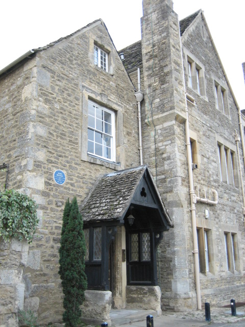
The village is nestled amidst rolling countryside, offering stunning views of the surrounding fields and meadows. Marston is characterized by its traditional architecture, with many of its buildings dating back several centuries. The village center is home to a range of amenities, including a post office, a convenience store, and a handful of local shops and businesses.

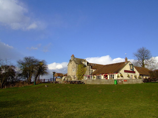
Marston is also well-known for its strong sense of community. The village hosts regular events and activities, such as festivals and fairs, which bring residents together and foster a friendly atmosphere. The village pub, The Victoria Arms, is a popular gathering spot for locals and visitors alike, offering a warm and welcoming ambiance.

Nature enthusiasts will appreciate Marston's proximity to several green spaces and nature reserves. The nearby University Parks and Shotover Country Park provide ample opportunities for outdoor activities such as walking, cycling, and picnicking. Additionally, the River Cherwell flows through Marston, offering scenic riverside walks and opportunities for boating.

With its idyllic countryside setting and close proximity to Oxford, Marston offers a perfect balance between peaceful village life and access to urban amenities. Whether one seeks tranquillity, community spirit, or outdoor recreation, Marston provides a delightful place to live or visit in Oxfordshire.

If you have any feedback on the listing, please let us know in the comments section below.

Marston Images

Images are sourced within 2km of 51.775635/-1.2382429 or Grid Reference SP5208. Thanks to Geograph Open Source API. All images are credited.

The Manor, home of John Buchan The Manor at Elsfield was the home of John Buchan from 1919 - 1935
The Manor, home of John Buchan
The Manor at Elsfield was the home of John Buchan from 1919 - 1935
The Manor House, Elsfield
Blue plaque for John Buchan On the wall of the Manor House, Elsfield <a href="https://www.geograph.org.uk/photo/334513">SP5310 : The Manor House, Elsfield</a>
Blue plaque for John Buchan
On the wall of the Manor House, Elsfield SP5310 : The Manor House, Elsfield
Tree reflected in wet wheatfield After heavy rain there was standing water in the field. Photo from road just by Bayswater Brook.
Tree reflected in wet wheatfield
After heavy rain there was standing water in the field. Photo from road just by Bayswater Brook.
Wet field near Marston Common Just by the bridge over Bayswater Brook. Field wet after heavy rain.
Wet field near Marston Common
Just by the bridge over Bayswater Brook. Field wet after heavy rain.
Bayswater Brook View by road to Woodeaton. Looking at the map, the brook has a rather circuitous route, from Shotover, past Sandhills and Barton, by Old Marston , back north to this site and a kilometre on joins the Cherwell.
Bayswater Brook
View by road to Woodeaton. Looking at the map, the brook has a rather circuitous route, from Shotover, past Sandhills and Barton, by Old Marston , back north to this site and a kilometre on joins the Cherwell.
Bridge or Raft Recent flooding almost covers this footbridge.
Bridge or Raft
Recent flooding almost covers this footbridge.
Bridleway to Cherwell Farm Off the lane to Woodeaton the bridleway to Cherwell farm
Bridleway to Cherwell Farm
Off the lane to Woodeaton the bridleway to Cherwell farm
Bridleway heading down to Long Wood Bridleway heading down to Long Wood and on to the Woodeaton lane
Bridleway heading down to Long Wood
Bridleway heading down to Long Wood and on to the Woodeaton lane
The dovecote behind Home farm
A40 Oxford Ring Road curving north of the Cherwell
Dovecote, Home Farm, Elsfield 18C dovecote on the listed buildings index. <span class="nowrap"><a title="http://www.britishlistedbuildings.co.uk/en-246573-home-farmhouse-dovecote-approximately-80" rel="nofollow ugc noopener" href="http://www.britishlistedbuildings.co.uk/en-246573-home-farmhouse-dovecote-approximately-80">Link</a><img style="margin-left:2px;" alt="External link" title="External link - shift click to open in new window" src="https://s1.geograph.org.uk/img/external.png" width="10" height="10"/></span>
Dovecote, Home Farm, Elsfield
18C dovecote on the listed buildings index. LinkExternal link
Peacock at Church Farm In the square by a couple of metres. 4 squares intersect more or less in this yard.
Peacock at Church Farm
In the square by a couple of metres. 4 squares intersect more or less in this yard.
Road to Sescut Farm
Road to Sescut Farm
Elsfield Manor Just in the square by a few metres, this large but rather bleak looking manor house was from 1919 to 1935 the home of the 1st Baron Tweedsmuir of Elsfield, author John Buchan.
I knew about his writing, but I never knew he was governor general of Canada as well.
Apparently so, according to the blue plaque on the wall.
Elsfield Manor
Just in the square by a few metres, this large but rather bleak looking manor house was from 1919 to 1935 the home of the 1st Baron Tweedsmuir of Elsfield, author John Buchan. I knew about his writing, but I never knew he was governor general of Canada as well. Apparently so, according to the blue plaque on the wall.
The Road Past Sescut Farm
Track at Lane End Farm
The road to Marston
The road to Marston
Show me another place!

Marston is located at Grid Ref: SP5208 (Lat: 51.775635, Lng: -1.2382429)

Administrative County: Oxfordshire

District: Oxford

Police Authority: Thames Valley

What 3 Words

///losses.people.gives. Near Oxford, Oxfordshire

Nearby Locations

Old Marston Marston

Related Wikis

Marston, Oxford

Marston is a village in the civil parish of Old Marston about 2 miles (3 km) northeast of the centre of Oxford, England. It was absorbed within the city...

Swan School, Oxford

The Swan School is a coeducational secondary school and sixth form located in Marston, Oxford. The school opened in September 2019 and was Oxford's first...

Victoria Arms, Marston

The Victoria Arms (known locally as the Vicky Arms and formerly as the Ferry Inn) is a pub on the eastern bank of the River Cherwell at the end of Mill...

Long Crendon F.C.

Long Crendon Football Club is a football club based in Long Crendon, Buckinghamshire, England. They are currently members of the Hellenic League Division...

Oxford City Nomads F.C.

Oxford City Nomads Football Club was a football club based in Oxford, England. == History == The club was established in 1936 as Quarry Nomads, a youth...

Oxford United W.F.C.

Oxford United Women's Football Club is an English women's football club affiliated with Oxford United, and founded in 2005. They had major success in their...

Oxford City F.C.

Oxford City Football Club is a semi-professional association football club based in Marston, Oxford, England. In 2023–24 they will compete in the National...

Marston Ferry Road

Marston Ferry Road is a link road in north Oxford, England. It is named after the ferry that used to cross the River Cherwell at the village of Marston...

Nearby Amenities

Located within 500m of 51.775635,-1.2382429
Turning Circle
Turning Circle: hammer
Lat/Long: 51.7761353/-1.2348873
Turning Circle
Turning Circle: knuckle
Lat/Long: 51.7748772/-1.2366723
Turning Circle
Lat/Long: 51.7724407/-1.2351681
Turning Circle
Lat/Long: 51.7776615/-1.2381808
Turning Circle
Lat/Long: 51.7785194/-1.2385963
Marston
Place: village
Lat/Long: 51.7761475/-1.2379075
Barrier: stile
Foot: yes
Source: photograph
Lat/Long: 51.7752511/-1.2323311
The Three Horseshoes
Former Amenity: pub
Source: photograph
Lat/Long: 51.7746953/-1.2375966
Post Box
Collection Times: Mo-Fr 17:00; Sa 11:30
Operator: Royal Mail
Operator Type: private
Operator Wikidata: Q638098
Post Box Type: lamp
Ref: OX3 192
Royal Cypher: EIIR
Royal Cypher Wikidata: Q33102113
Source: photograph
Lat/Long: 51.7744569/-1.237436
Barrier: cycle_barrier
Foot: yes
Lat/Long: 51.7719392/-1.234297
Library
Old Marston Library
Opening Hours: Tu,Th 14:00-17:00,17:30-19:00; Fr 10:00-12:00,14:00-17:00; Sa 09:30-12:30
Source: yahoo_imagery
Source Name: photograph
Wheelchair: yes
Wikidata: Q55112970
Lat/Long: 51.7718956/-1.2364367
Community Centre
Mortimer Hall
Source: yahoo_imagery
Source Name: photograph
Lat/Long: 51.7718167/-1.236538
Barrier: stile
Lat/Long: 51.7731572/-1.2415658
Barrier: kissing_gate
Lat/Long: 51.7735012/-1.2411187
Barrier: entrance
Lat/Long: 51.7745786/-1.2445799
Barrier: entrance
Lat/Long: 51.7739517/-1.2421107
Barrier: entrance
Lat/Long: 51.7735594/-1.241042
Man Made: mast
Note: I'm not sure what it's used for. It's a metal mast, not very tall.
Tower Construction: lattice_steel
Tower Type: communication
Lat/Long: 51.7728793/-1.2413949
Bicycle Parking
Capacity: 4
Lat/Long: 51.7717478/-1.2364003
Barrier: bollard
Lat/Long: 51.7712716/-1.2367885
Barrier: stile
Lat/Long: 51.778332/-1.2366526
Maxspeed: 20 mph
Maxspeed Note: Oxford 20 mph zone
Maxspeed Spec: 50m SE of junction with South Croft (sic)
Traffic Calming: choker
Lat/Long: 51.7754406/-1.233416
Bus Stop
St Nicholas Church
Bus: yes
Local Ref: o/s
Naptan AtcoCode: 340000013CHU
Naptan Bearing: E
Naptan CommonName: St Nicholas Church
Naptan Indicator: Outside
Naptan Landmark: Church Hall
Naptan NaptanCode: oxfamjdw
Naptan PlusbusZoneRef: OXFD
Naptan Street: Elsfield Road
Public Transport: platform
Route Ref: 14A;17C
Shelter: no
Source: naptan_import
Lat/Long: 51.7757668/-1.2367683
Bus Stop
St Nicholas Church
Bus: yes
Local Ref: opp
Naptan AtcoCode: 340000013OCH
Naptan Bearing: W
Naptan CommonName: St Nicholas Church
Naptan Indicator: Opposite
Naptan Landmark: Church
Naptan NaptanCode: oxfatmjw
Naptan PlusbusZoneRef: OXFD
Naptan Street: Elsfield Road
Public Transport: platform
Route Ref: 14A;17C
Shelter: yes
Source: naptan_import
Tactile Paving: no
Lat/Long: 51.7756632/-1.2373261
Bus Stop
Old Marston Library
Bench: no
Bin: no
Bus: yes
Local Ref: opp
Naptan AtcoCode: 340001284OPP
Naptan Bearing: S
Naptan CommonName: Old Marston Library
Naptan Indicator: Opposite
Naptan Landmark: Library
Naptan NaptanCode: oxfgmtad
Naptan PlusbusZoneRef: OXFD
Naptan Street: Oxford Road
Naptan Verified: no
Public Transport: platform
Route Ref: 14A;17C
Shelter: no
Source: naptan_import
Tactile Paving: no
Lat/Long: 51.7721958/-1.2360815
Bus Stop
Old Marston Library
Bench: yes
Bus: yes
Local Ref: o/s
Naptan AtcoCode: 340001284OUT
Naptan Bearing: N
Naptan CommonName: Old Marston Library
Naptan Indicator: Outside
Naptan Landmark: Library
Naptan NaptanCode: oxfgmtag
Naptan PlusbusZoneRef: OXFD
Naptan Street: Oxford Road
Public Transport: platform
Route Ref: 14A;17C
Shelter: yes
Source: naptan_import
Lat/Long: 51.771839/-1.2362909
Bus Stop
Old Three Horseshoes
Bench: no
Bin: yes
Bus: yes
Local Ref: opp
Naptan AtcoCode: 340001285OPP
Naptan Bearing: N
Naptan CommonName: Post Office
Naptan Indicator: Opposite
Naptan Landmark: Post Office
Naptan NaptanCode: oxfgmtaj
Naptan PlusbusZoneRef: OXFD
Naptan Street: Oxford Road
Naptan Verified: no
Old Name: Post Office
Public Transport: platform
Route Ref: 14A;17C
Shelter: no
Source: naptan_import
Tactile Paving: no
Lat/Long: 51.7746502/-1.2377925
Bus Stop
Old Three Horseshoes
Bench: no
Bin: yes
Bus: yes
Local Ref: o/s
Naptan AtcoCode: 340001285OUT
Naptan Bearing: S
Naptan CommonName: Post Office
Naptan Indicator: Outside
Naptan Landmark: Post Office
Naptan NaptanCode: oxfgmtam
Naptan PlusbusZoneRef: OXFD
Naptan Street: Oxford Road
Naptan Verified: no
Old Name: Post Office
Public Transport: platform
Route Ref: 14A;17C
Shelter: no
Source: naptan_import
Tactile Paving: no
Lat/Long: 51.7749583/-1.2379186
Bradlands
Frequency: 0
Naptan AtcoCode: 340004133BRD
Naptan Bearing: W
Naptan BusStopType: CUS
Naptan CommonName: Bradlands
Naptan Crossing: Mill Lane
Naptan Indicator: Flats
Naptan PlusbusZoneRef: OXFD
Naptan Street: Bradlands
Naptan Verified: no
Source: naptan_import
Lat/Long: 51.7786195/-1.2412045
Post Box
Collection Times: Mo-Fr 17:00; Sa 11:30
Operator: Royal Mail
Operator Type: private
Operator Wikidata: Q638098
Ref: OX3 861
Royal Cypher: EIIR
Lat/Long: 51.7782906/-1.2406281
Barrier: kissing_gate
Lat/Long: 51.7736832/-1.2408938
Barrier: kissing_gate
Lat/Long: 51.7746648/-1.2393479
Source: survey
Traffic Calming: choker
Lat/Long: 51.7756198/-1.2345364
Source: survey
Traffic Calming: choker
Lat/Long: 51.7721611/-1.2361545
Barrier: stile
Lat/Long: 51.7722516/-1.2341249
Source: survey
Traffic Calming: choker
Lat/Long: 51.7731139/-1.2366057
Source: survey
Traffic Calming: choker
Lat/Long: 51.7738872/-1.2369289
Barrier: stile
Foot: yes
Lat/Long: 51.7746997/-1.2335139
Source: survey
Traffic Calming: choker
Lat/Long: 51.7749178/-1.2379571
Source: survey
Traffic Calming: choker
Lat/Long: 51.7757161/-1.2355403
Source: survey
Traffic Calming: choker
Lat/Long: 51.7757201/-1.2365115
Barrier: bollard
Bicycle: yes
Foot: yes
Lat/Long: 51.772987/-1.2398988
Barrier: bollard
Bicycle: yes
Foot: yes
Lat/Long: 51.7730385/-1.2399994
Barrier: bollard
Bicycle: yes
Lat/Long: 51.7743004/-1.2435356
Barrier: bollard
Bicycle: yes
Lat/Long: 51.7743232/-1.2436287
Barrier: kissing_gate
Lat/Long: 51.7770033/-1.2413886
Traffic Calming: bump
Lat/Long: 51.7771703/-1.2408046
Recycling
Operator: British Heart Foundation
Recycling Clothes: yes
Recycling Type: container
Lat/Long: 51.7777811/-1.2365298
Barrier: cycle_barrier
Foot: yes
Lat/Long: 51.7770933/-1.2373231
Barrier: bollard
Bicycle: yes
Bollard: fixed
Foot: yes
Lat/Long: 51.7784183/-1.2391059
Royalist surrender at Oxford
Historic: memorial
Inscription Url: http://www.oxonblueplaques.org.uk/plaques/civil_war.html
Memorial: blue_plaque
Lat/Long: 51.7764231/-1.2389315
Turning Circle
Lat/Long: 51.7743459/-1.2367125
Defibrillator
Defibrillator Location: Outside wall of Mortimer Hall / Old Marston Library
Emergency: defibrillator
Emergency Phone: 999
Lat/Long: 51.7718422/-1.2364313
Waste Basket
Waste: trash
Lat/Long: 51.7716467/-1.2363897
Barrier: cycle_barrier
Foot: yes
Lat/Long: 51.771651/-1.2364173
Operator: SSE Power Distribution
Power: substation
Ref: Oxford Road 1511
Substation: minor_distribution
Lat/Long: 51.7715911/-1.2362167
Barrier: swing_gate
Lat/Long: 51.771991/-1.2342438
Barrier: swing_gate
Swing Gate Type: single
Lat/Long: 51.7721011/-1.2342387
Waste Basket
Waste: trash
Lat/Long: 51.772472/-1.2335573
Waste Basket
Waste: trash
Lat/Long: 51.7725134/-1.2338242
Scout Hut
43rd Oxford (St Nicholas) Scout Group
Lat/Long: 51.7723927/-1.2343432
Waste Basket
Waste: trash
Lat/Long: 51.7719396/-1.2343298
Barrier: entrance
Lat/Long: 51.772544/-1.2339879
Turning Circle
Lat/Long: 51.7721384/-1.235231
Turning Circle
Lat/Long: 51.7744706/-1.2369543
Crossing
Kerb: flush
Lat/Long: 51.775513/-1.2341102
Crossing
Crossing: uncontrolled
Lat/Long: 51.7757649/-1.2349584
Crossing
Crossing: uncontrolled
Lat/Long: 51.7757806/-1.2368791
Crossing
Lat/Long: 51.7728866/-1.2397174
Speed Camera
Direction: 150
Lat/Long: 51.7713194/-1.2370655
Direction: 185
Generator Method: photovoltaic
Generator Output Electricity: yes
Generator Solar Modules: 22
Generator Source: solar
Generator Type: solar_photovoltaic_panel
Location: roof
Power: generator
Lat/Long: 51.7730988/-1.2375673
Fixme: solar panels?
Lat/Long: 51.7729526/-1.2359823
Direction: 185
Fixme: survey for panel count
Generator Method: photovoltaic
Generator Output Electricity: yes
Generator Solar Modules: 7
Generator Source: solar
Generator Type: solar_photovoltaic_panel
Location: roof
Power: generator
Lat/Long: 51.7746198/-1.236433
Direction: 175
Fixme: survey for panel count
Generator Method: photovoltaic
Generator Output Electricity: yes
Generator Solar Modules: 10
Generator Source: solar
Generator Type: solar_photovoltaic_panel
Location: roof
Power: generator
Lat/Long: 51.7749893/-1.2366341
Fixme: solar panels?
Lat/Long: 51.7749468/-1.2357854
Direction: 195
Fixme: survey for panel count
Generator Method: photovoltaic
Generator Output Electricity: yes
Generator Solar Modules: 12
Generator Source: solar
Generator Type: solar_photovoltaic_panel
Location: roof
Power: generator
Lat/Long: 51.7748195/-1.2349228
Direction: 195
Generator Method: photovoltaic
Generator Output Electricity: yes
Generator Solar Modules: 9
Generator Source: solar
Generator Type: solar_photovoltaic_panel
Location: roof
Power: generator
Lat/Long: 51.7754649/-1.2342678
Direction: 145
Fixme: survey for panel count
Generator Method: photovoltaic
Generator Output Electricity: yes
Generator Solar Modules: 10
Generator Source: solar
Generator Type: solar_photovoltaic_panel
Location: roof
Power: generator
Lat/Long: 51.7750852/-1.2361805
Direction: 175
Fixme: survey for panel count
Generator Method: photovoltaic
Generator Output Electricity: yes
Generator Solar Modules: 3
Generator Source: solar
Generator Type: solar_photovoltaic_panel
Location: roof
Power: generator
Lat/Long: 51.7753873/-1.2371483
Direction: 175
Fixme: survey for panel count & types
Generator Method: photovoltaic
Generator Output Electricity: yes
Generator Solar Modules: 19
Generator Source: solar
Generator Type: solar_photovoltaic_panel
Location: roof
Power: generator
Lat/Long: 51.7754038/-1.2374334
Crossing
Crossing: uncontrolled
Lat/Long: 51.7756295/-1.2345959
The data included in this document is from www.openstreetmap.org. The data is made available under ODbL.

Have you been to Marston?

Leave your review of Marston below (or comments, questions and feedback).