Mount Pleasant

Settlement in Norfolk Norwich

England

Mount Pleasant

River Wensum Just below the limit of navigation for boats, which is up by the trees in the distance.
River Wensum Credit: Des Blenkinsopp

Mount Pleasant is a neighborhood located in the city of Norfolk, Virginia. Situated in the eastern part of the city, it is bounded by North Military Highway to the west, Virginia Beach Boulevard to the south, and Northampton Boulevard to the east. The community is known for its mix of residential, commercial, and industrial developments.

Residentially, Mount Pleasant boasts a variety of housing options, including single-family homes, townhouses, and apartment complexes. The neighborhood offers a suburban atmosphere, with tree-lined streets and well-maintained properties. Residents enjoy access to several parks and green spaces, providing ample opportunities for outdoor activities.

The commercial sector in Mount Pleasant is vibrant, featuring a range of businesses, shops, and restaurants. The neighborhood is home to several shopping centers, providing convenient access to daily necessities and services. In addition, the area has a reputation for its local dining scene, offering diverse culinary options to suit various tastes.

Mount Pleasant also houses numerous industrial facilities, contributing to the local economy. These include manufacturing plants, warehouses, and distribution centers. The neighborhood benefits from its proximity to major transportation routes, such as interstates and highways, facilitating the movement of goods and services.

Overall, Mount Pleasant offers a balanced blend of residential, commercial, and industrial components, making it an attractive place to live, work, and visit within the city of Norfolk.

If you have any feedback on the listing, please let us know in the comments section below.

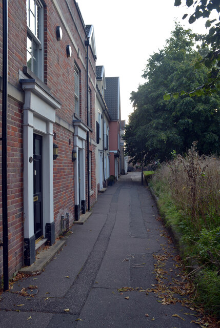
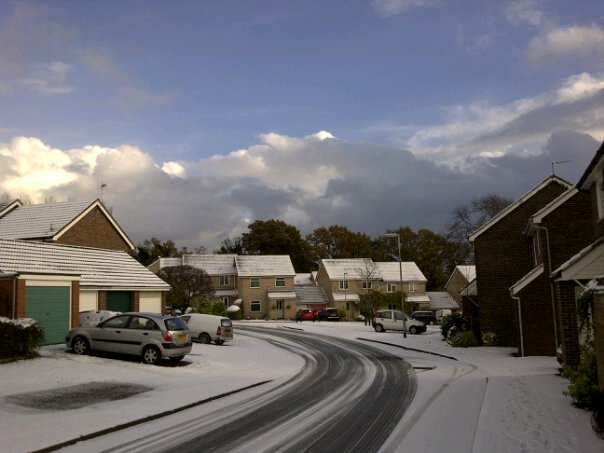
Mount Pleasant Images

Images are sourced within 2km of 52.619021/1.2735345 or Grid Reference TG2107. Thanks to Geograph Open Source API. All images are credited.

River Wensum Just below the limit of navigation for boats, which is up by the trees in the distance.
River Wensum
Just below the limit of navigation for boats, which is up by the trees in the distance.
Flowers by the City Wall A section of the old City Wall with some colourful wild flowers.
Flowers by the City Wall
A section of the old City Wall with some colourful wild flowers.
Premier Inn, Duke Street, Norwich
The Oak Circus Centre and St. Miles Alley, Norwich The Oak Circus Centre is a training and education space, events venue, rehearsals space and community resource. It is situated in the early 16th century St Michael Coslany, a Grade 1 listed building.
The Oak Circus Centre and St. Miles Alley, Norwich
The Oak Circus Centre is a training and education space, events venue, rehearsals space and community resource. It is situated in the early 16th century St Michael Coslany, a Grade 1 listed building.
Oak Street, Norwich
Oak Street, Norwich
Indigo Yard, Norwich
St. Miles Alley, Norwich
St. Andrew's Car Park, Duke Street, Norwich
Church of St. John the Baptist seen from St. John's Alley, Norwich
Guildhall Hill, Norwich
St. Giles Street, Norwich
St. Giles on the Hill, Norwich
The Cathedral of St. John the Baptist, Norwich The Cathedral, located on Earlham Road, was constructed between 1882 and 1910 to designs by George Gilbert Scott, Jr. as a parish church dedicated to John the Baptist, on the site of the Norwich City Gaol.The funds for its construction were provided by Henry Fitzalan-Howard, 15th Duke of Norfolk. In 1976 it was consecrated as the cathedral church for the newly erected Diocese of East Anglia and the seat of the Bishop of East Anglia. It is the second largest Roman Catholic cathedral in England.
It is one of two cathedrals in the city of Norwich, and should not be confused with the Church of England Norwich Cathedral, completed in the Norman style in 1145.
Grade I listed. <span class="nowrap"><a title="http://www.britishlistedbuildings.co.uk/en-229040-roman-catholic-cathedral-of-st-john-the-" rel="nofollow ugc noopener" href="http://www.britishlistedbuildings.co.uk/en-229040-roman-catholic-cathedral-of-st-john-the-">Link</a><img style="margin-left:2px;" alt="External link" title="External link - shift click to open in new window" src="https://s1.geograph.org.uk/img/external.png" width="10" height="10"/></span>
The Cathedral of St. John the Baptist, Norwich
The Cathedral, located on Earlham Road, was constructed between 1882 and 1910 to designs by George Gilbert Scott, Jr. as a parish church dedicated to John the Baptist, on the site of the Norwich City Gaol.The funds for its construction were provided by Henry Fitzalan-Howard, 15th Duke of Norfolk. In 1976 it was consecrated as the cathedral church for the newly erected Diocese of East Anglia and the seat of the Bishop of East Anglia. It is the second largest Roman Catholic cathedral in England. It is one of two cathedrals in the city of Norwich, and should not be confused with the Church of England Norwich Cathedral, completed in the Norman style in 1145. Grade I listed. LinkExternal link
Unthank Road, Norwich A close-up of the post box can be seen in <a href="https://www.geograph.org.uk/photo/7000311">TG2208 : Post box, Clarendon Road, Norwich</a>.
Unthank Road, Norwich
A close-up of the post box can be seen in TG2208 : Post box, Clarendon Road, Norwich.
Post box, Clarendon Road, Norwich This post box can be seen in context in <a href="https://www.geograph.org.uk/photo/7000309">TG2208 : Unthank Road, Norwich</a>.
Post box, Clarendon Road, Norwich
This post box can be seen in context in TG2208 : Unthank Road, Norwich.
Grosvenor Road, Norwich
Show me another place!

Mount Pleasant is located at Grid Ref: TG2107 (Lat: 52.619021, Lng: 1.2735345)

Administrative County: Norfolk

District: Norwich

Police Authority: Norfolk

What 3 Words

///sharp.mats.tilt. Near Norwich, Norfolk

Nearby Locations

Arlington Mount Pleasant

Related Wikis

Norwich South (UK Parliament constituency)

Norwich South is a constituency in Norfolk represented in the House of Commons of the Parliament of the United Kingdom, since 2015 by Clive Lewis, of the...

Town Close School

Town Close School is an independent preparatory school located in Norwich, England. The heart of the School is two large town houses, one early Georgian...

City of Norwich School

The City of Norwich School, more commonly known as CNS, is a coeducational secondary school and sixth form with academy status in Norwich, England. �...

Eaton, Norfolk

Eaton is a suburb of the city of Norwich, in the Norwich district, in the county town of Norfolk, England. Anciently the superiority of manor of Eaton...

Nearby Amenities

Located within 500m of 52.619021,1.2735345
Crossing
Crossing: traffic_signals
Crossing Island: no
Crossing Ref: pelican
Tactile Paving: yes
Lat/Long: 52.6190857/1.2692965
Traffic Signals
Lat/Long: 52.6194444/1.26859
Crossing
Crossing: unmarked
Crossing Island: yes
Crossing Markings: no
Tactile Paving: yes
Lat/Long: 52.6193663/1.268347
Traffic Signals
Lat/Long: 52.6206992/1.2708813
Traffic Signals
Lat/Long: 52.6173161/1.2762825
Traffic Calming: cushion
Lat/Long: 52.6195328/1.2726877
Traffic Calming: hump
Lat/Long: 52.6226445/1.2736038
Give Way
Lat/Long: 52.6189355/1.2801915
Traffic Signals
Lat/Long: 52.6154727/1.2706123
Traffic Calming: cushion
Lat/Long: 52.6205311/1.2711781
Addr City: Norwich
Addr Country: GB
Addr Housenumber: 1d
Addr Postcode: NR2 2AD
Addr Street: Christchurch Road
Fixme: check address
Source Addr Postcode: code-point_open
Lat/Long: 52.6177681/1.27423
Give Way
Lat/Long: 52.6195025/1.2774057
Crossing
Bicycle: yes
Crossing: unmarked
Crossing Island: no
Tactile Paving: no
Lat/Long: 52.6172095/1.2763487
Post Box
Check Date Collection Times: 2023-02-17
Collection Times: Mo-Fr 09:00; Sa 07:00
Operator: Royal Mail
Post Box Type: pillar
Ref: NR4 435D
Royal Cypher: EIIR
Royal Cypher Wikidata: Q33102113
Lat/Long: 52.6157747/1.2719012
Post Box
Collection Times: Mo-Fr 16:45; Sa 11:30
Operator: Royal Mail
Post Box Type: pillar
Ref: NR4 420
Royal Cypher: GVIR
Royal Cypher Wikidata: Q33102169
Lat/Long: 52.6180188/1.2674439
Post Box
Collection Times: Mo-Fr 16:45; Sa 11:45
Operator: Royal Mail
Post Box Type: pillar
Ref: NR2 215
Royal Cypher: EIIR
Royal Cypher Wikidata: Q33102113
Source Date: 2019-04-03
Lat/Long: 52.6229238/1.27586
Telephone
Booth: KX100
Check Date: 2023-02-17
Covered: booth
Operator: BT
Payment Coins: yes
Payment Credit Cards: yes
Payment Debit Cards: yes
Payment Telephone Cards: yes
Lat/Long: 52.6229056/1.2758879
Post Box
Collection Times: Mo-Fr 09:00; Sa 07:00
Operator: Royal Mail
Post Box Type: pillar
Ref: NR2 208D
Royal Cypher: EIIR
Royal Cypher Wikidata: Q33102113
Lat/Long: 52.6201578/1.2700555
Post Box
Collection Times: Mo-Fr 17:15; Sa 11:15
Operator: Royal Mail
Post Box Type: pillar
Ref: NR2 212
Royal Cypher: EIIR
Royal Cypher Wikidata: Q33102113
Lat/Long: 52.6170655/1.2766027
Post Box
Collection Times: Mo-Fr 09:00; Sa 07:00
Operator: Royal Mail
Post Box Type: pillar
Ref: NR2 221D
Royal Cypher: GR
Royal Cypher Wikidata: Q33102273
Lat/Long: 52.6220451/1.2691972
Brand: T-Mobile UK
Communication Mobile Phone: yes
Man Made: mast
Material: metal
Operator: EE;Three UK
Ref: 78251 MBNL
Tower Construction: freestanding
Tower Type: communication
Lat/Long: 52.6154299/1.2751292
Bus Stop
High School
Bus: yes
Naptan AtcoCode: 2900N12139
Naptan Bearing: NW
Naptan CommonName: High School
Naptan Indicator: adj
Naptan Landmark: High School
Naptan Locality: Norwich
Naptan NaptanCode: nfodjada
Naptan PlusbusZoneRef: NRCH
Naptan Street: Newmarket Road
Note: Bearing should be SE
Public Transport: platform
Route Ref: 44
Shelter: no
Source: naptan_import;survey
Lat/Long: 52.618037/1.2752544
Bus Stop
Norwich / Newmarket Road / Albemarle Road
Bench: no
Bin: no
Bus: yes
Lit: no
Naptan AtcoCode: 2900N12349
Naptan Bearing: SW
Naptan CommonName: Albemarle Road
Naptan Indicator: opp
Naptan Landmark: Abemarle Road
Naptan Locality: Norwich
Naptan NaptanCode: nfodjmwg
Naptan PlusbusZoneRef: NRCH
Naptan Street: Newmarket Road
Public Transport: platform
Shelter: no
Source: naptan_import;survey
Tactile Paving: yes
Lat/Long: 52.6183195/1.2795067
Bus Stop
Norwich / Newmarket Road / Lime Tree Road
Bench: yes
Bin: yes
Bus: yes
Lit: yes
Naptan AtcoCode: 2900N12351
Naptan Bearing: NE
Naptan CommonName: Lime Tree Road
Naptan Indicator: opp
Naptan Latitude: 52.61721
Naptan Locality: Norwich
Naptan Longitude: 1.275562
Naptan NaptanCode: nfodjmwm
Naptan PlusbusZoneRef: NRCH
Naptan Street: Newmarket Road
Public Transport: platform
Shelter: yes
Source: naptan_import;survey
Tactile Paving: no
Lat/Long: 52.6170991/1.2753846
Bus Stop
Newmarket Road / High School
Bench: no
Bin: no
Bus: yes
Lit: yes
Naptan AtcoCode: 2900N12352
Naptan Bearing: NE
Naptan CommonName: Albemarle Road
Naptan Indicator: adj
Naptan Landmark: Albermarle Road
Naptan Locality: Norwich
Naptan NaptanCode: nfodjmwp
Naptan PlusbusZoneRef: NRCH
Naptan Street: Newmarket Road
Public Transport: platform
Shelter: no
Source: naptan_import;survey
Tactile Paving: no
Lat/Long: 52.6179797/1.2780048
Bus Stop
Leopold Road, adj
Bench: yes
Bin: yes
Bus: yes
Lit: yes
Naptan AtcoCode: 2900N12353
Naptan Bearing: NE
Naptan CommonName: Leopold Road
Naptan Indicator: adj
Naptan Locality: Norwich
Naptan NaptanCode: nfodjmwt
Naptan PlusbusZoneRef: NRCH
Naptan Street: Newmarket Road
Naptan Verified: no
Operator: First Eastern Counties;Anglian Coaches Ltd.;Konectbus;H.Semmence & Co. Ltd.;Norfolk Green;Eagles Coaches
Public Transport: platform
Shelter: yes
Source: naptan_import
Tactile Paving: no
Lat/Long: 52.6159213/1.2717569
Bus Stop
Norwich / Newmarket Road / Limetree Road
Bench: yes
Bin: yes
Bus: yes
Lit: yes
Naptan AtcoCode: 2900N12354
Naptan Bearing: SW
Naptan CommonName: Lime Tree Road
Naptan Indicator: adj
Naptan Locality: Norwich
Naptan NaptanCode: nfodjpad
Naptan PlusbusZoneRef: NRCH
Naptan Street: Newmarket Road
Note: Sign road name should be 'Lime Tree Road'
Public Transport: platform
Shelter: yes
Source: naptan_import;survey
Tactile Paving: no
Lat/Long: 52.6168683/1.2750978
Bus Stop
Newmarket Rd / Eaton Road
Bench: yes
Bin: yes
Bus: yes
Lit: yes
Naptan AtcoCode: 2900N12355
Naptan Bearing: SW
Naptan CommonName: Eaton Road
Naptan Indicator: adj
Naptan Landmark: Recreation Ground
Naptan Locality: Norwich
Naptan NaptanCode: nfodjpag
Naptan PlusbusZoneRef: NRCH
Naptan Street: Newmarket Road
Operator: First Eastern Counties;Anglian Coaches Ltd.;Konectbus;H.Semmence & Co. Ltd.;Norfolk Green;Eagles Coaches
Public Transport: platform
Shelter: no
Source: naptan_import;survey
Tactile Paving: no
Lat/Long: 52.6158051/1.2718871
Bus Stop
Mount Pleasant
Bench: no
Bin: yes
Bus: yes
Lit: no
Naptan AtcoCode: 2900N12408
Naptan Bearing: NE
Naptan BusStopType: CUS
Naptan CommonName: Lincoln Street
Naptan Indicator: adj
Naptan Landmark: Lincoln Street
Naptan Latitude: 52.6225406
Naptan Locality: Norwich
Naptan Longitude: 1.2746894
Naptan NaptanCode: nfodjtda
Naptan PlusbusZoneRef: NRCH
Naptan Street: Unthank Road
Public Transport: platform
Ref: NFODJTDA
Shelter: no
Source: naptan_import;survey
Tactile Paving: no
Lat/Long: 52.6219495/1.2733971
Bus Stop
Norwich / Mount Pleasant
Bench: no
Bin: no
Bus: yes
Lit: no
Naptan AtcoCode: 2900N12409
Naptan Bearing: SW
Naptan BusStopType: CUS
Naptan CommonName: Lincoln Street
Naptan Indicator: opp
Naptan Landmark: College Road
Naptan Latitude: 52.6221799
Naptan Locality: Norwich
Naptan Longitude: 1.2740713
Naptan NaptanCode: nfodjtdg
Naptan PlusbusZoneRef: NRCH
Naptan Street: Unthank Road
Public Transport: platform
Shelter: no
Source: naptan_import;survey
Tactile Paving: yes
Lat/Long: 52.622039/1.2737601
Bus Stop
Norwich / Unthank Road
Bench: no
Bin: no
Bus: yes
Lit: no
Naptan AtcoCode: 2900N12410
Naptan Bearing: NE
Naptan BusStopType: CUS
Naptan CommonName: Glebe Road
Naptan Indicator: adj
Naptan Locality: Norwich
Naptan NaptanCode: nfodjtdj
Naptan PlusbusZoneRef: NRCH
Naptan Street: Unthank Road
Public Transport: platform
Shelter: no
Source: naptan_import;survey
Tactile Paving: yes
Lat/Long: 52.62104/1.2715056
Bus Stop
Norwich / Unthank Road Colman Road
Bench: no
Bin: yes
Bus: yes
Lit: yes
Naptan AtcoCode: 2900N12411
Naptan Bearing: NE
Naptan CommonName: Colman Hospital
Naptan Indicator: adj
Naptan Locality: Norwich
Naptan NaptanCode: nfodjtdm
Naptan PlusbusZoneRef: NRCH
Naptan Street: Unthank Road
Public Transport: platform
Shelter: yes
Source: naptan_import;survey
Tactile Paving: no
Lat/Long: 52.6199311/1.2694222
Bus Stop
Norwich / Unthank Road Colman Road
Bench: no
Bin: no
Bus: yes
Lit: yes
Naptan AtcoCode: 2900N12412
Naptan Bearing: SW
Naptan BusStopType: CUS
Naptan CommonName: Colman Hospital
Naptan Indicator: opp
Naptan Locality: Norwich
Naptan NaptanCode: nfodjtdp
Naptan PlusbusZoneRef: NRCH
Naptan Street: Unthank Road
Public Transport: platform
Shelter: no
Source: naptan_import;survey
Tactile Paving: no
Lat/Long: 52.620219/1.270138
Bus Stop
Norwich / Colman Road
Bench: no
Bin: no
Bus: yes
Lit: no
Naptan AtcoCode: 2900N12413
Naptan Bearing: NW
Naptan BusStopType: CUS
Naptan CommonName: Mornington Road
Naptan Indicator: opp
Naptan Latitude: 52.6200493
Naptan Locality: Norwich
Naptan Longitude: 1.266878
Naptan NaptanCode: nfodjtdt
Naptan PlusbusZoneRef: NRCH
Naptan Street: Colman Road
Operator: First Eastern Counties
Public Transport: platform
Shelter: no
Source: naptan_import;survey
Tactile Paving: yes
Lat/Long: 52.6198317/1.2673905
Bus Stop
Plantsman Close
Bench: no
Bin: no
Bus: yes
Lit: no
Naptan AtcoCode: 2900N12595
Naptan Bearing: SE
Naptan BusStopType: CUS
Naptan CommonName: Plantsman Close
Naptan Indicator: adj
Naptan Landmark: Plantsman Close
Naptan Locality: Norwich
Naptan NaptanCode: nfodmgat
Naptan PlusbusZoneRef: NRCH
Naptan Street: Daniels Road
Public Transport: platform
Shelter: no
Source: naptan_import;survey
Tactile Paving: yes
Lat/Long: 52.61561/1.275062
Bus Stop
Melrose Road
Bus: yes
Naptan AtcoCode: 2900N12596
Naptan Bearing: SE
Naptan CommonName: Melrose Road
Naptan Indicator: opp
Naptan Landmark: Waldeck Road
Naptan Locality: Norwich
Naptan NaptanCode: nfodmgaw
Naptan PlusbusZoneRef: NRCH
Naptan Street: Mile End Road
Operator: First Eastern Counties
Physically Present: no
Public Transport: platform
Source: naptan_import;survey
Lat/Long: 52.6189867/1.2695326
Barrier: bollard
Bicycle: yes
Bollard: fixed
Foot: yes
Lat/Long: 52.6215145/1.2789923
Barrier: bollard
Bicycle: yes
Bollard: fixed
Foot: yes
Lat/Long: 52.6213073/1.2785603
Waste Basket
Colour: green
Material: plastic
Lat/Long: 52.6214239/1.2791813
Waste Basket
Check Date: 2021-07-24
Lat/Long: 52.6159255/1.271912
Waste Basket
Check Date: 2021-06-06
Lat/Long: 52.6157911/1.2719031
Waste Basket
Check Date: 2021-06-06
Lat/Long: 52.6175444/1.2772387
Crossing
Crossing: unmarked
Crossing Island: yes
Tactile Paving: no
Lat/Long: 52.618631/1.2802433
Crossing
Bicycle: yes
Button Operated: yes
Crossing: traffic_signals
Crossing Island: no
Crossing Ref: toucan
Tactile Paving: yes
Traffic Signals Sound: walk
Lat/Long: 52.6159534/1.2744858
Crossing
Bicycle: yes
Crossing: unmarked
Crossing Island: no
Tactile Paving: no
Lat/Long: 52.6153791/1.2706897
Barrier: bollard
Bicycle: yes
Bollard: fixed
Lat/Long: 52.615767/1.271967
Crossing
Bicycle: yes
Crossing: unmarked
Tactile Paving: no
Lat/Long: 52.6160972/1.2729097
Crossing
Bicycle: yes
Crossing: unmarked
Crossing Island: no
Tactile Paving: no
Lat/Long: 52.6186131/1.2806916
Crossing
Crossing: uncontrolled
Crossing Island: no
Crossing Ref: zebra
Kerb: lowered
Tactile Paving: yes
Lat/Long: 52.622341/1.2744569
Waste Basket
Check Date: 2023-02-17
Lat/Long: 52.6199513/1.2694697
Waste Basket
Colour: green
Material: plastic
Lat/Long: 52.6219453/1.2733873
Crossing
Crossing: unmarked
Crossing Island: no
Tactile Paving: no
Lat/Long: 52.6163283/1.2734017
Crossing
Crossing: unmarked
Crossing Island: no
Tactile Paving: no
Lat/Long: 52.6167643/1.2734803
Crossing
Crossing: unmarked
Crossing Island: no
Tactile Paving: no
Lat/Long: 52.616696/1.2733882
Crossing
Crossing: unmarked
Crossing Island: no
Tactile Paving: no
Lat/Long: 52.6167022/1.274188
Traffic Calming: cushion
Lat/Long: 52.6180385/1.2751277
Traffic Calming: hump
Lat/Long: 52.6232994/1.2729402
Traffic Calming: hump
Lat/Long: 52.6222779/1.2725614
Traffic Calming: hump
Lat/Long: 52.6229651/1.2718703
Crossing
Crossing: traffic_signals
Crossing Island: yes
Tactile Paving: yes
Lat/Long: 52.6155424/1.2708556
Crossing
Crossing: unmarked
Crossing Island: no
Tactile Paving: no
Lat/Long: 52.6166123/1.2742294
Crossing
Crossing: unmarked
Crossing Island: no
Tactile Paving: no
Lat/Long: 52.6164097/1.2733386
Crossing
Button Operated: yes
Crossing: traffic_signals
Crossing Island: yes
Tactile Paving: yes
Traffic Signals Vibration: no
Lat/Long: 52.6173675/1.2765245
Crossing
Crossing: traffic_signals
Crossing Island: yes
Tactile Paving: yes
Lat/Long: 52.6174545/1.2765682
Crossing
Crossing: unmarked
Crossing Island: yes
Tactile Paving: no
Lat/Long: 52.6173972/1.2761719
Give Way
Lat/Long: 52.6201372/1.2670003
Speed Camera
Ref: F33
Website: http://norfolk-safety-camera.org.uk/index.php?page=fixedinfo
Lat/Long: 52.6182003/1.2705992
Traffic Calming: cushion
Lat/Long: 52.6175777/1.2758669
Traffic Calming: cushion
Lat/Long: 52.6200783/1.2718609
Traffic Calming: cushion
Lat/Long: 52.6191059/1.273367
Traffic Calming: cushion
Lat/Long: 52.6184685/1.2744189
Bench
Backrest: yes
Check Date: 2021-06-04
Material: wood
Lat/Long: 52.6161107/1.2730478
Bench
Backrest: yes
Check Date: 2021-05-01
Material: wood
Lat/Long: 52.6166696/1.2745837
Street Lamp
Lat/Long: 52.6167562/1.2736528
Street Lamp
Lat/Long: 52.6168455/1.2733137
Crossing
Button Operated: yes
Crossing: traffic_signals
Crossing Island: no
Crossing Ref: pelican
Tactile Paving: yes
Lat/Long: 52.6202163/1.2667348
Crossing
Crossing: unmarked
Crossing Island: yes
Kerb: flush
Tactile Paving: no
Lat/Long: 52.6181457/1.2787651
Barrier: bollard
Bollard: fixed
Lat/Long: 52.6192913/1.2770648
Grit Bin
Lat/Long: 52.6186064/1.2668872
Cycleway: asl
Lat/Long: 52.6193176/1.2682069
Entrance: main
Lat/Long: 52.6231522/1.2729172
Bench
Backrest: yes
Colour: brown
Material: wood
Seats: 3
Lat/Long: 52.6195283/1.2685803
Crossing
Crossing: uncontrolled
Lat/Long: 52.6202773/1.2692347
Crossing
Crossing: uncontrolled
Lat/Long: 52.6205102/1.2695164
Milestone
Distance Norwich: 1 mi
Distance Thetford: 28 mi
Material: wood
Note: 1m high wooden square post with pyramidal top, no inscription. The only thing that could be the marker in the area.
Lat/Long: 52.6183916/1.2797905
Entrance: main
Lat/Long: 52.6183243/1.2722504
Give Way
Lat/Long: 52.6215012/1.2696019
Give Way
Lat/Long: 52.621541/1.2696871
Give Way
Lat/Long: 52.6223751/1.2687057
Give Way
Lat/Long: 52.6224094/1.2687878
Traffic Calming: hump
Lat/Long: 52.621646/1.2695157
Traffic Calming: hump
Lat/Long: 52.6222109/1.2689343
Give Way
Lat/Long: 52.6219304/1.2691638
Give Way
Lat/Long: 52.6219653/1.2692465
Give Way
Lat/Long: 52.6174021/1.2679249
Give Way
Lat/Long: 52.6174537/1.2678765
Location: overground
Power: transformer
Transformer: distribution
Lat/Long: 52.6199795/1.2675856
Cafe
Kofra
Addr City: Norwich
Addr Housenumber: 16
Addr Postcode: NR2 2EB
Addr Street: Onley Street
Capacity: 8
Cuisine: coffee_shop;cakes
Fhrs Id: 1080661
Internet Access: wlan
Internet Access Fee: no
Outdoor Seating: yes
Source Addr: FHRS Open Data
Lat/Long: 52.6227471/1.2773436
Waste Basket
Lat/Long: 52.623072/1.2762794
Bicycle Parking
Bicycle Parking: stands
Capacity: 4
Covered: no
Lat/Long: 52.6230527/1.2762252
Grit Bin
Lat/Long: 52.6229689/1.275613
Grit Bin
Lat/Long: 52.6226676/1.27487
Grit Bin
Lat/Long: 52.622329/1.2740251
Crossing
Crossing: unmarked
Tactile Paving: no
Lat/Long: 52.6188962/1.2694328
Crossing
Crossing: traffic_signals
Crossing Island: no
Crossing Ref: pelican
Tactile Paving: yes
Lat/Long: 52.6190043/1.2693346
Crossing
Crossing: unmarked
Crossing Island: yes
Tactile Paving: yes
Lat/Long: 52.619651/1.268103
Crossing
Crossing: unmarked
Crossing Island: no
Tactile Paving: yes
Lat/Long: 52.6201493/1.2670118
Crossing
Button Operated: yes
Crossing: traffic_signals
Crossing Island: no
Crossing Ref: pelican
Tactile Paving: yes
Lat/Long: 52.6201523/1.2667409
Give Way
Lat/Long: 52.6179533/1.2713799
Give Way
Lat/Long: 52.6178295/1.2713848
Give Way
Lat/Long: 52.6184105/1.2703449
Give Way
Lat/Long: 52.6187543/1.2667068
Power: transformer
Lat/Long: 52.6196936/1.2771307
Peartree Bindery
Addr City: Norwich
Addr Housenumber: 173
Addr Postcode: NR2 2PG
Addr Street: Unthank Road
Craft: bookbinder
Website: http://peartreebindery.co.uk/
Lat/Long: 52.6227921/1.27501
Bicycle Rental
Unthank Road/Colman Road
Bicycle Rental: dropoff_point
Capacity: 10
Email: support@beryl.cc
Fee: yes
Name Signed: no
Network: Beryl - Norwich
Official Name: Unthank Road/Colman Road
Operator: Beryl
Operator Wikidata: Q106575369
Payment App: yes
Payment App Android: cc.beryl.basis
Payment App Ios: 1386768364
Payment Cash: no
Payment Credit Cards: no
Payment Cryptocurrencies: no
Payment Debit Cards: no
Payment Electronic Purses: no
Phone: +44 20 3003 5044
Ref Gbfs: beryl_norwich:1873
Rental: city_bike;ebike;escooter
Website: https://beryl.cc/scheme/norwich
Lat/Long: 52.6194572/1.268293
Waste Basket
Colour: green
Material: plastic
Lat/Long: 52.6167219/1.2748565
Waste Basket
Colour: green
Material: plastic
Lat/Long: 52.6197842/1.2692073
Waste Basket
Colour: green
Material: plastic
Lat/Long: 52.6210438/1.2796307
Waste Basket
Colour: green
Material: plastic
Lat/Long: 52.616026/1.2727448
Waste Basket
Colour: green
Material: plastic
Lat/Long: 52.6209442/1.278952
Waste Basket
Colour: green
Material: plastic
Lat/Long: 52.6156513/1.2750833
Waste Basket
Colour: green
Material: plastic
Lat/Long: 52.6182004/1.2673476
Waste Basket
Colour: green
Material: plastic
Lat/Long: 52.6185313/1.2802743
Waste Basket
Colour: green
Material: plastic
Lat/Long: 52.6162209/1.2726694
Waste Basket
Colour: green
Material: plastic
Lat/Long: 52.6169873/1.2750305
Mount Pleasant
Place: neighbourhood
Lat/Long: 52.6199663/1.2760502
Give Way
Lat/Long: 52.6187227/1.2803252
Telephone
Booth: KX100
Covered: booth
Lat/Long: 52.6228951/1.2759134
Entrance: main
Lat/Long: 52.6209147/1.2690617
Entrance: main
Lat/Long: 52.6207027/1.2694325
Give Way
Lat/Long: 52.6231003/1.2718323
Generator Method: photovoltaic
Generator Output Electricity: yes
Generator Solar Modules: 14
Generator Source: solar
Generator Type: solar_photovoltaic_panel
Location: roof
Power: generator
Lat/Long: 52.6200941/1.2797946
Crossing
Kerb: yes
Surface: bitmac
Tactile Paving: no
Traffic Calming: choker
Lat/Long: 52.6181895/1.2675908
Give Way
Lat/Long: 52.6181036/1.2672682
Give Way
Lat/Long: 52.6180517/1.2673151
Man Made: utility_pole
Material: wood
Utility: telecom
Lat/Long: 52.6194193/1.2688619
Man Made: utility_pole
Material: wood
Utility: telecom
Lat/Long: 52.6202646/1.270247
Man Made: utility_pole
Material: wood
Utility: telecom
Lat/Long: 52.6197737/1.2694021
Man Made: utility_pole
Material: wood
Utility: telecom
Lat/Long: 52.6211048/1.2701418
Man Made: utility_pole
Material: wood
Utility: telecom
Lat/Long: 52.6200548/1.2717965
Man Made: utility_pole
Material: wood
Utility: telecom
Lat/Long: 52.6187097/1.2688196
Man Made: utility_pole
Material: wood
Utility: telecom
Lat/Long: 52.6185564/1.2684219
Man Made: utility_pole
Material: wood
Utility: telecom
Lat/Long: 52.6184301/1.2680666
Man Made: utility_pole
Material: wood
Utility: telecom
Lat/Long: 52.6179987/1.2672713
Man Made: utility_pole
Material: wood
Utility: telecom
Lat/Long: 52.6184888/1.2670198
Man Made: utility_pole
Material: wood
Utility: telecom
Lat/Long: 52.6194245/1.2682918
The data included in this document is from www.openstreetmap.org. The data is made available under ODbL.

Have you been to Mount Pleasant?

Leave your review of Mount Pleasant below (or comments, questions and feedback).