Mixon

Settlement in Staffordshire Staffordshire Moorlands

England

Mixon

The Stable at Harvey Gate
The Stable at Harvey Gate Credit: Alex McGregor

Mixon is a small village located in the Staffordshire county of England. Situated in the West Midlands region, it falls within the district of East Staffordshire. The village is nestled in a picturesque rural setting, surrounded by rolling hills and lush green countryside.

Mixon is known for its tranquil atmosphere and close-knit community. With a population of just over 500 residents, it offers a peaceful and quiet escape from the hustle and bustle of city life. The village is primarily residential, with a few local amenities that cater to the needs of its residents.

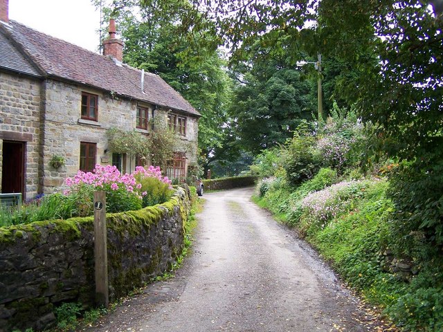
The village is home to a charming parish church, which dates back to the 13th century, adding a touch of historical significance to the area. The church is a focal point for the community and hosts regular religious services and events.

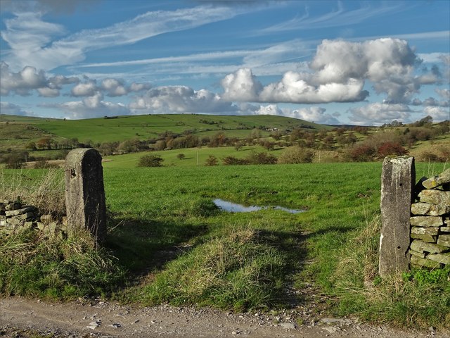
Mixon is also blessed with beautiful natural surroundings, making it an ideal location for outdoor enthusiasts. The nearby countryside provides ample opportunities for hiking, cycling, and exploring the scenic landscapes. The village is surrounded by several walking trails, offering stunning views of the Staffordshire countryside.

Despite its small size, Mixon benefits from good transportation links. The village is well-connected to nearby towns and cities, with regular bus services and easy access to major road networks. This allows residents to easily commute to nearby employment centers or access a wider range of amenities and services.

In summary, Mixon is a charming village in Staffordshire that offers a peaceful and idyllic lifestyle. With its beautiful surroundings, close-knit community, and easy access to transportation links, it provides an attractive living environment for its residents.

If you have any feedback on the listing, please let us know in the comments section below.

Mixon Images

Images are sourced within 2km of 53.112841/-1.9371095 or Grid Reference SK0457. Thanks to Geograph Open Source API. All images are credited.

The Stable at Harvey Gate
New house
New house
Former Ford at Onecote This point is marked on the OS 1:25000 map as a ford but is now culverted with a substantial pipe.
Former Ford at Onecote
This point is marked on the OS 1:25000 map as a ford but is now culverted with a substantial pipe.
Roadside, Blakelow Road Looking across the wall and signs towards the lane to Clough House Farm.
Roadside, Blakelow Road
Looking across the wall and signs towards the lane to Clough House Farm.
Mill Lea near Onecote
Onecote Grange, Staffordshire
The track to Mixon From Onecote Grange
The track to Mixon
From Onecote Grange
At Mixon - junction of tracks
Young bull above The River Hamps He was guarding the public right of way, causing me to divert into the adjacent field.
Young bull above The River Hamps
He was guarding the public right of way, causing me to divert into the adjacent field.
Building at  Mixon's former copper mine
Building at Mixon's former copper mine
View to Brund Hays from Black Brook
Longhorn cow by Farmoor
Staffordshire Countryside Looking north from Far Moor
Staffordshire Countryside
Looking north from Far Moor
Footbridge over The River Hamps
Approaching Black Brook When another Geograph member passed by here in 2011, the farm appeared to be abandoned but it has clearly enjoyed rejuvenation since then:- <a title="https://www.geograph.org.uk/photo/2515522" href="https://www.geograph.org.uk/photo/2515522">Link</a>
Approaching Black Brook
When another Geograph member passed by here in 2011, the farm appeared to be abandoned but it has clearly enjoyed rejuvenation since then:- Link
On the track from Farmoor
View across the Hamps Valley from Mixon
Onecote Lane Head Douse Lane, Onecote, Staffordshire
Onecote Lane Head
Douse Lane, Onecote, Staffordshire
Show me another place!

Mixon is located at Grid Ref: SK0457 (Lat: 53.112841, Lng: -1.9371095)

Administrative County: Staffordshire

District: Staffordshire Moorlands

Police Authority: Staffordshire

What 3 Words

///kindness.adjuster.feelers. Near Leek, Staffordshire

Nearby Locations

Mixon

Related Wikis

Morridge

Morridge is a geographical feature, a few mile east of Leek, in Staffordshire, England. It is in the local government district of Staffordshire Moorlands...

Elkstones

Elkstones is a small hamlet in the parish of Warslow and Elkstones, consisting of Upper Elkstone and Lower Elkstone. Situated high in the Staffordshire...

River Hamps

The River Hamps is a river in Staffordshire, England. It is a tributary of the River Manifold, which itself flows into the River Dove near Ilam. For much...

Warslow and Elkstones

Warslow and Elkstones is a civil parish in the district of Staffordshire Moorlands in north-east Staffordshire, England. It includes the village of Warslow...

Thorncliffe, Staffordshire

Thorncliffe is a small village in Staffordshire, England, straddling the Staffordshire Moorlands and Peak District National Park. By 1600 the name Thorncliffe...

Butterton

Butterton is a small village in the Staffordshire Peak District of England (grid reference SK075565). It overlooks the Manifold Valley and Ecton Hill,...

Onecote

Onecote is a village and civil parish on the B5053 road, near Leek, in the Staffordshire Moorlands district, in the county of Staffordshire, England. The...

St Bartholomew's Church, Butterton

St Bartholomew's Church, Butterton is a Grade II listed parish church in the Church of England in Butterton. == History == St Bartholomew's Church was...

Nearby Amenities

Located within 500m of 53.112841,-1.9371095
Barrier: cattle_grid
Lat/Long: 53.1123685/-1.93269
Barrier: stile
Lat/Long: 53.1124892/-1.930485
Barrier: stile
Lat/Long: 53.1166065/-1.9343979
Barrier: stile
Material: stone
Source: survey;gps
Stile: stepover
Lat/Long: 53.1124569/-1.9401919
Barrier: stile
Material: steel
Source: survey;gps
Stile: stepover
Lat/Long: 53.1105632/-1.9375261
Barrier: stile
Material: wood
Source: survey;gps
Stile: stepover
Lat/Long: 53.1109781/-1.9378908
Barrier: stile
Material: wood
Source: survey;gps
Stile: stepover
Lat/Long: 53.1111295/-1.9380548
Information: guidepost
Operator: Peak & Northern Footpaths Society
Ref: 407
Source: survey;gps
Tourism: information
Lat/Long: 53.1122175/-1.9423788
Barrier: stile
Material: wood
Source: survey;gps
Stile: stepover
Lat/Long: 53.1123093/-1.9392529
Barrier: stile
Material: stone
Source: survey;gps
Stile: stepover
Lat/Long: 53.1125585/-1.9394575
Information: guidepost
Operator: Peak & Northern Footpaths Society
Ref: 405
Source: survey;gps
Tourism: information
Lat/Long: 53.1125624/-1.9394742
Barrier: stile
Material: stone
Source: survey;gps
Stile: stepover
Lat/Long: 53.1130241/-1.9408118
Barrier: stile
Material: wood
Source: survey;gps
Stile: stepover
Lat/Long: 53.1133334/-1.9425778
Information: guidepost
Operator: Peak & Northern Footpaths Society
Ref: 406
Source: survey;gps
Tourism: information
Lat/Long: 53.1127373/-1.9386623
Barrier: cattle_grid
Bicycle: yes
Foot: yes
Lat/Long: 53.1128012/-1.9382218
Barrier: stile
Material: wood
Source: survey;gps
Stile: stepover
Lat/Long: 53.113144/-1.9357699
Barrier: stile
Material: wood
Source: survey;gps
Stile: stepover
Lat/Long: 53.1132883/-1.9339558
Barrier: stile
Material: stone
Source: survey;gps
Stile: stepover
Lat/Long: 53.1133611/-1.9336745
Barrier: stile
Material: wood
Source: survey;gps
Stile: stepover
Lat/Long: 53.1134913/-1.9336768
Barrier: stile
Material: wood
Source: survey;gps
Stile: stepover
Lat/Long: 53.1145595/-1.9335287
Barrier: stile
Material: wood
Source: survey;gps
Stile: stepover
Lat/Long: 53.1127947/-1.9330703
Barrier: stile
Material: wood
Source: survey;bing
Stile: stepover
Lat/Long: 53.1128069/-1.9313399
Barrier: entrance
Source: survey;gps
Lat/Long: 53.1131344/-1.9321944
Barrier: cattle_grid
Lat/Long: 53.1107613/-1.9349254
Barrier: cattle_grid
Lat/Long: 53.1108144/-1.9346048
Mixon
Place: hamlet
Lat/Long: 53.1129317/-1.9360611
The data included in this document is from www.openstreetmap.org. The data is made available under ODbL.

Have you been to Mixon?

Leave your review of Mixon below (or comments, questions and feedback).