Lesnes Abbey

Settlement in Kent

England

Lesnes Abbey

sunset Sunset over Southmere Lake with the flats in shadow
sunset Credit: Linda Craven

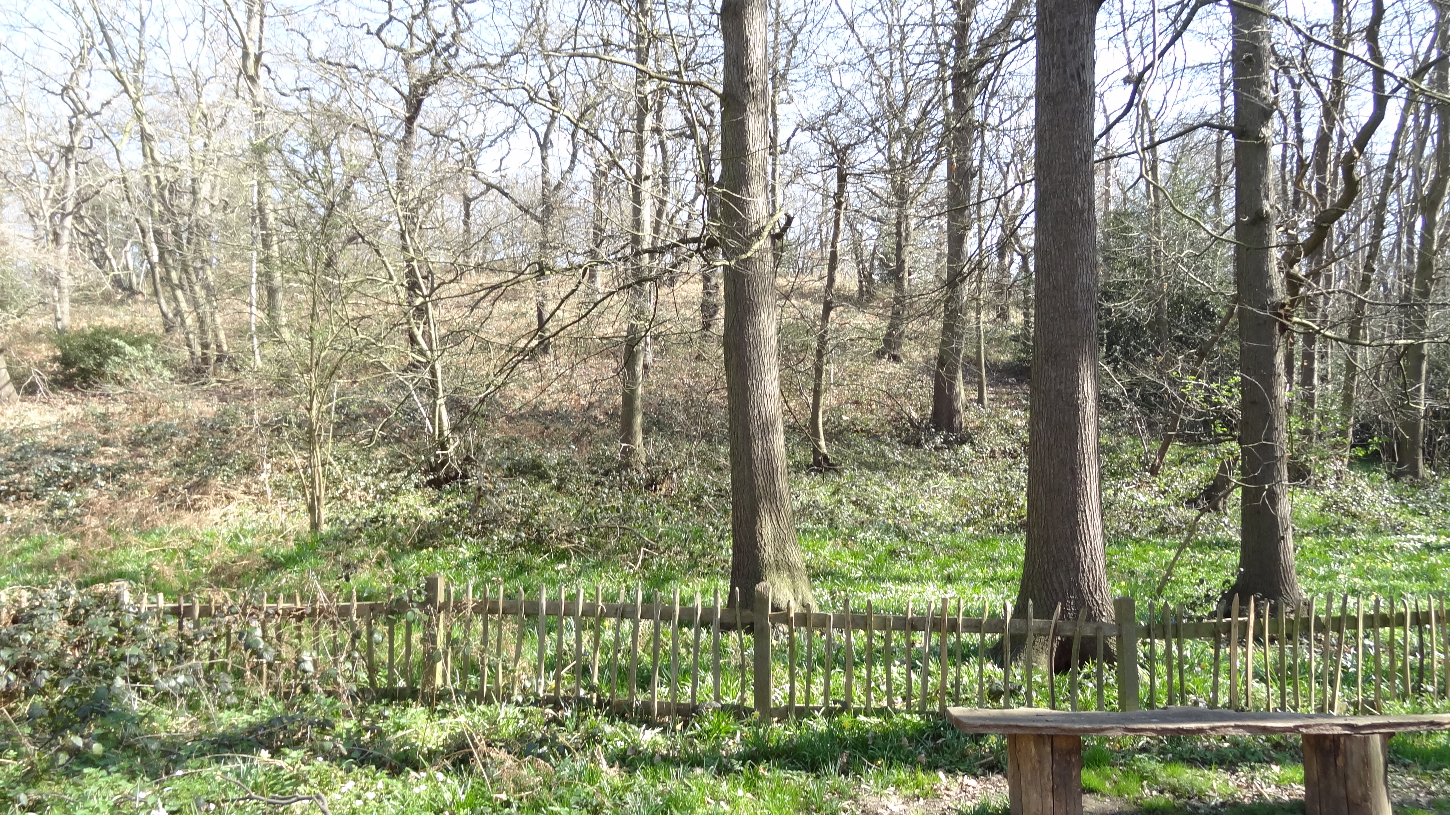
Lesnes Abbey, located in the county of Kent, England, is a historic site that once housed a medieval monastery. Situated in the borough of Bexley, Lesnes Abbey is surrounded by the picturesque Lesnes Abbey Woods, a nature reserve that covers an area of 88 hectares.

Originally founded in 1178, Lesnes Abbey was a priory of the Augustinian order and served as a religious institution until its dissolution in 1525. The abbey had a significant influence on the local community, providing spiritual guidance and contributing to the area's economic development through its agricultural activities.

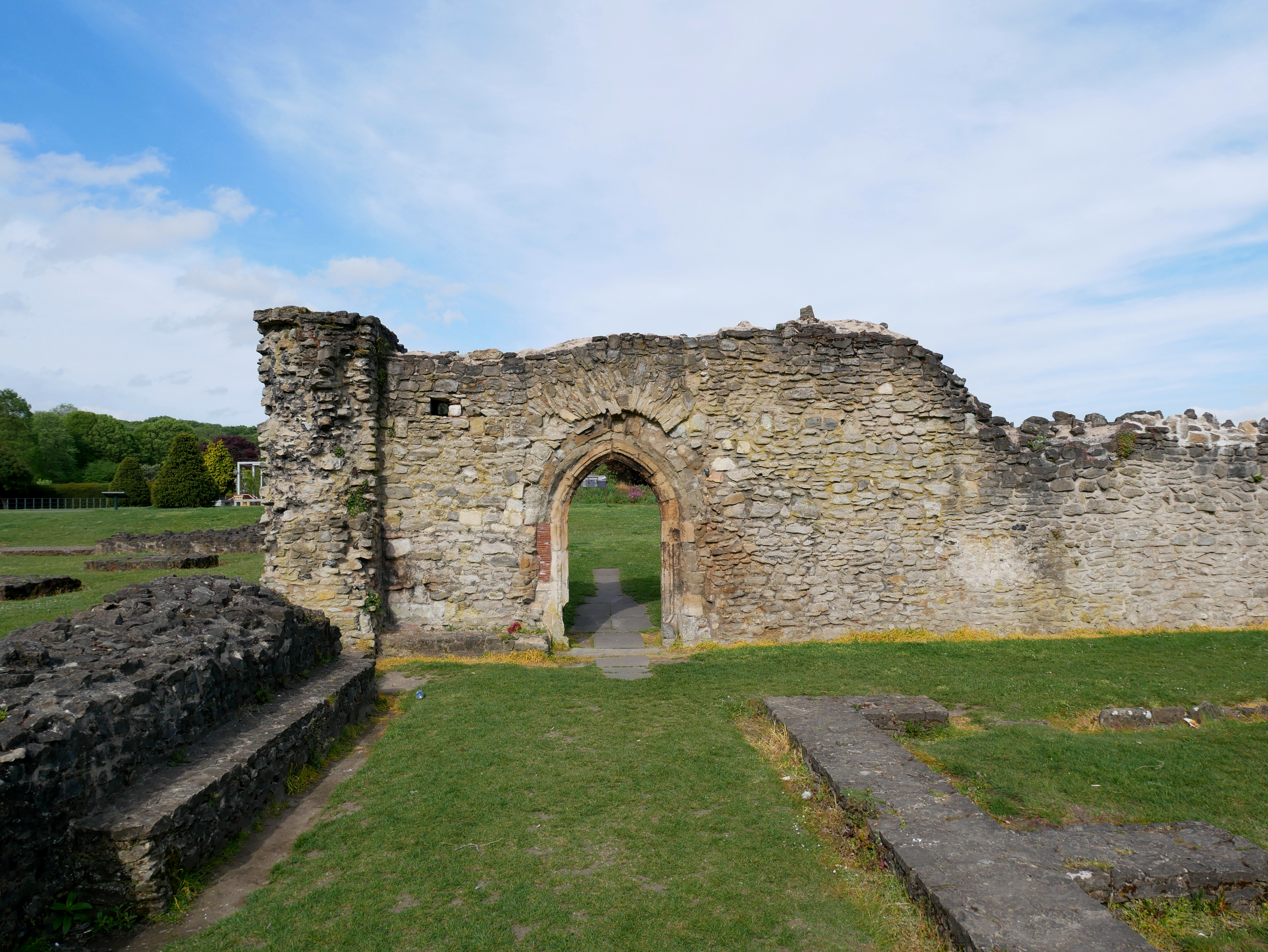
Today, all that remains of the original abbey are the ruins, but they serve as a poignant reminder of the site's historical importance. The ruins include sections of the church, cloister, chapter house, and dormitory. Visitors can explore these remnants, offering an insight into the architectural style and daily life of the abbey's inhabitants.

Lesnes Abbey is also home to a modern visitor center, which provides more information about the site's history and offers educational resources for school groups. The surrounding Lesnes Abbey Woods, managed by the London Borough of Bexley, provide a tranquil setting for leisurely walks and nature exploration.

In recent years, efforts have been made to restore and preserve the ruins and enhance the visitor experience at Lesnes Abbey. The site attracts both history enthusiasts and nature lovers who appreciate the unique combination of historical significance and natural beauty that Lesnes Abbey has to offer.

If you have any feedback on the listing, please let us know in the comments section below.

Lesnes Abbey Images

Images are sourced within 2km of 51.482387/0.12561475 or Grid Reference TQ4778. Thanks to Geograph Open Source API. All images are credited.

sunset Sunset over Southmere Lake with the flats in shadow
sunset
Sunset over Southmere Lake with the flats in shadow
Abbey Wood station The 'far south eastern' suburb of Abbey Wood is a long way from Central London.  London's last tram route, which closed on 7 July 1952, ran all the way from here to the Embankment, taking well over an hour.  In the present photograph, a new Class 376 unit heads an up service to London Charing Cross.
Abbey Wood station
The 'far south eastern' suburb of Abbey Wood is a long way from Central London. London's last tram route, which closed on 7 July 1952, ran all the way from here to the Embankment, taking well over an hour. In the present photograph, a new Class 376 unit heads an up service to London Charing Cross.
Abbey Wood Library, Eynsham Drive, London SE2 At the time of the photograph, the library and the attached parade of shops and attached flats were receiving a major refurbishment.
Abbey Wood Library, Eynsham Drive, London SE2
At the time of the photograph, the library and the attached parade of shops and attached flats were receiving a major refurbishment.
Terrace houses, Blithdale Road, Abbey Wood, London SE2 A style of housing popular between the wars.  Whilst Blithdale Road is a pleasant enough road in most respects, it would appear that there are some dog owners hereabouts who would benefit from a little advice from the local Public Health department.
Terrace houses, Blithdale Road, Abbey Wood, London SE2
A style of housing popular between the wars. Whilst Blithdale Road is a pleasant enough road in most respects, it would appear that there are some dog owners hereabouts who would benefit from a little advice from the local Public Health department.
St. Michael and All Angels Church, Abbey Wood Road, London SE2 The local Church of England has a large and active congregation.  There is also a Catholic church just around the corner.
St. Michael and All Angels Church, Abbey Wood Road, London SE2
The local Church of England has a large and active congregation. There is also a Catholic church just around the corner.
Byway Open to All Traffic (BOAT) BOATs are not so common in London as they are in some other areas.  This one is called Leather Bottle Lane and is at the north edge of Lesnes Abbey Woods in Belvedere, Kent.  Thankfully, no-one was trying to drive a motor vehicle down it.
Byway Open to All Traffic (BOAT)
BOATs are not so common in London as they are in some other areas. This one is called Leather Bottle Lane and is at the north edge of Lesnes Abbey Woods in Belvedere, Kent. Thankfully, no-one was trying to drive a motor vehicle down it.
Parkway Primary School, Alsike Road, Erith, Kent A large modern primary school serving an area of mostly new housing.
Parkway Primary School, Alsike Road, Erith, Kent
A large modern primary school serving an area of mostly new housing.
Lesnes Abbey ruins, Belvedere, Kent Not much left of the actual abbey now, but the ruins stand in pleasant parkland, with picnic facilities and Lesnes Abbey Wood nearby.
Lesnes Abbey ruins, Belvedere, Kent
Not much left of the actual abbey now, but the ruins stand in pleasant parkland, with picnic facilities and Lesnes Abbey Wood nearby.
Congregational Church, Picardy Road, Belvedere, Kent This very pleasant building seems to be about 100 years old, but there has been a church on this site for longer than that: the First Edition six-inch map labels a "Bapt. Ch." at this spot, which was then almost in open country.
Congregational Church, Picardy Road, Belvedere, Kent
This very pleasant building seems to be about 100 years old, but there has been a church on this site for longer than that: the First Edition six-inch map labels a "Bapt. Ch." at this spot, which was then almost in open country.
The Bedon Stream, Lessness Heath, Belvedere, Kent I was at first unable to discover an official name for this minute brook, but a local person told me that it was called The Streamway.  He also said that many years ago watercress was cultivated here.  However, a correspondent has now contacted me with the information that the correct name is The Bedon Stream.
The Bedon Stream, Lessness Heath, Belvedere, Kent
I was at first unable to discover an official name for this minute brook, but a local person told me that it was called The Streamway. He also said that many years ago watercress was cultivated here. However, a correspondent has now contacted me with the information that the correct name is The Bedon Stream.
Trees and daffodils, Bedonwell Road, Bexley, Kent It's early April, and the daffodils and a blossom tree are out in this roadside view in Bexley.
Trees and daffodils, Bedonwell Road, Bexley, Kent
It's early April, and the daffodils and a blossom tree are out in this roadside view in Bexley.
St. Andrew's Church, Brampton Road, Belvedere, Kent A workman carries out maintenance on the garden wall of this very pleasing modern Church of England building.
St. Andrew's Church, Brampton Road, Belvedere, Kent
A workman carries out maintenance on the garden wall of this very pleasing modern Church of England building.
Plumstead Cemetery The sun obliged me by being in just the right position for this shot of Plumstead Cemetery with its very elaborate spired mortuary chapel, constructed of limestone.
Plumstead Cemetery
The sun obliged me by being in just the right position for this shot of Plumstead Cemetery with its very elaborate spired mortuary chapel, constructed of limestone.
Mortuary chapel, Woolwich Old Cemetery A building of excellent appearance dating from the early Victorian years, it has a porch and spire, and is shaded by an old cedar tree.  This hillside cemetery appears open and uncrowded.
Mortuary chapel, Woolwich Old Cemetery
A building of excellent appearance dating from the early Victorian years, it has a porch and spire, and is shaded by an old cedar tree. This hillside cemetery appears open and uncrowded.
Stevens Park, East Wickham, Kent This grid square is almost all suburban housing built between the wars, but is relieved by the open space of the small Stevens Park.
Stevens Park, East Wickham, Kent
This grid square is almost all suburban housing built between the wars, but is relieved by the open space of the small Stevens Park.
St Peter's Church, Pickford Lane, Bexleyheath Sunday morning - but the place was completely deserted!
St Peter's Church, Pickford Lane, Bexleyheath
Sunday morning - but the place was completely deserted!
Abbey Wood railway station This building is the main entrance to the station, and can be seen to the right of the train in Neil's <a href="https://www.geograph.org.uk/photo/141798">TQ4779 : Abbey Wood station</a>. The station is currently the planned south-eastern terminus of the Crossrail project, and an image of the proposed re-design of the station can be found here <span class="nowrap"><a title="http://www.railway-technology.com/projects/crossrail/crossrail7.html" rel="nofollow ugc noopener" href="http://www.railway-technology.com/projects/crossrail/crossrail7.html">Link</a><img style="margin-left:2px;" alt="External link" title="External link - shift click to open in new window" src="https://s1.geograph.org.uk/img/external.png" width="10" height="10"/></span>
Abbey Wood railway station
This building is the main entrance to the station, and can be seen to the right of the train in Neil's TQ4779 : Abbey Wood station. The station is currently the planned south-eastern terminus of the Crossrail project, and an image of the proposed re-design of the station can be found here LinkExternal link
Thamesmead: A2041 Harrow Manorway footbridge The footbridge links the Abbey Wood Park area to Southmere.
Thamesmead: A2041 Harrow Manorway footbridge
The footbridge links the Abbey Wood Park area to Southmere.
Show me another place!

Lesnes Abbey is located at Grid Ref: TQ4778 (Lat: 51.482387, Lng: 0.12561475)

Unitary Authority: Bexley

Police Authority: Metropolitan

What 3 Words

///stages.bells.jolly. Near Abbey Wood, London

Related Wikis

Abbey Wood SSSI

Abbey Wood is a 6.3-hectare (16-acre) geological Site of Special Scientific Interest in Abbey Wood in the London Borough of Bexley. It is located in Lesnes...

West Heath, London

West Heath is an area of South East London within the London Borough of Bexley. It lies south of Abbey Wood and north of Welling. == Transport == West...

Lesnes Abbey

Lesnes Abbey is a former abbey, now ruined, in Abbey Wood, in the London Borough of Bexley, southeast London, England. It is a scheduled monument, and...

Lesnes Abbey Woods

Lesnes Abbey Woods, sometimes known as Abbey Wood, is a 73 ha ancient woodland in southeast London, England. It is located near to, and named after, the...

Nearby Amenities

Located within 500m of 51.482387,0.12561475
Fixme: is there a path into the wood from here?
Lat/Long: 51.483666/0.1281457
Turning Circle
Lat/Long: 51.4826813/0.1294552
Crossing
Crossing: traffic_signals
Crossing Island: yes
Crossing Ref: pelican
Tactile Paving: yes
Lat/Long: 51.4814992/0.1223012
Not Highway: turning_circle
Lat/Long: 51.4812018/0.127001
Barrier: cycle_barrier
Lat/Long: 51.4825279/0.1240711
Bus Stop
Woolwich Road / Bedonwell Road
Bus: yes
Local Ref: D
Naptan AtcoCode: 490003803E
Naptan Bearing: N
Naptan CommonName: Woolwich Road Bedonwell Road
Naptan Street: WOOLWICH ROAD
Naptan Verified: no
Public Transport: platform
Ref: 53343
Lat/Long: 51.4815353/0.1304852
Bus Stop
Woolwich Road / Bedonwell Road
Bus: yes
Local Ref: G
Naptan AtcoCode: 490003803W
Naptan Bearing: N
Naptan CommonName: Woolwich Road Bedonwell Road
Naptan Street: WOOLWICH ROAD
Naptan Verified: no
Public Transport: platform
Ref: 71358
Lat/Long: 51.4815213/0.1325378
Bus Stop
Woolwich Road / Brampton Road
Bus: yes
Local Ref: B
Naptan AtcoCode: 490004246E
Naptan Bearing: N
Naptan CommonName: Woolwich Road Brampton Road
Naptan Verified: no
Public Transport: platform
Ref: 53697
Source Ref: naptan
Lat/Long: 51.4814576/0.1231481
Bus Stop
Bostall Hill / Brampton Road
Bus: yes
Local Ref: J
Naptan AtcoCode: 490008867W
Naptan Bearing: N
Naptan CommonName: Bostall Hill Brampton Road
Naptan Verified: no
Public Transport: platform
Ref: 50257
Source Ref: naptan
Lat/Long: 51.4813212/0.1216875
Bus Stop
New Road
Bus: yes
Local Ref: C
Naptan AtcoCode: 490010253E
Naptan Bearing: N
Naptan CommonName: New Road Woolwich Road
Naptan Verified: no
Public Transport: platform
Ref: 74918
Lat/Long: 51.4814071/0.1276847
Bus Stop
New Road
Bus: yes
Local Ref: H
Naptan AtcoCode: 490010253W
Naptan Bearing: N
Naptan CommonName: New Road Woolwich Road
Naptan Verified: no
Public Transport: platform
Lat/Long: 51.4812198/0.1254427
Bus Stop
Hail & Ride Pinewood Road
Bus: yes
Naptan AtcoCode: 490011011N
Naptan Bearing: N
Naptan CommonName: Pinewood Road
Naptan Verified: no
Public Transport: platform
Lat/Long: 51.4790962/0.1231158
Bus Stop
Hail & Ride Pinewood Road
Bus: yes
Naptan AtcoCode: 490011011S
Naptan Bearing: N
Naptan CommonName: Pinewood Road
Naptan Verified: no
Public Transport: platform
Lat/Long: 51.479445/0.1231327
Bus Stop
Hurst Lane
Bus: yes
Local Ref: E
Naptan AtcoCode: 490016307N
Naptan Bearing: N
Naptan CommonName: Hurst Lane
Naptan Street: NEW ROAD
Naptan Verified: no
Public Transport: platform
Ref: 47687
Source Ref: naptan
Lat/Long: 51.4822597/0.1263141
Bus Stop
Hurst Lane
Bus: yes
Local Ref: F
Naptan AtcoCode: 490016307S
Naptan Bearing: S
Naptan CommonName: Hurst Lane
Naptan Street: NEW ROAD
Naptan Verified: no
Public Transport: platform
Ref: 58615
Lat/Long: 51.4823579/0.1264531
Barrier: cycle_barrier
Cycle Barrier: triple
Cycle Barrier Installation: openable
Foot: yes
Lat/Long: 51.4858841/0.1269368
Post Box
Brand: Royal Mail
Brand Wikidata: Q638098
Brand Wikipedia: en:Royal Mail
Collection Times: Mo-Fr 17:30; Sa 12:00
Drive Through: no
Operator: Royal Mail
Operator Wikidata: Q638098
Post Box Design: type_a
Post Box Type: pillar
Ref: SE2 10
Royal Cypher: GR
Royal Cypher Wikidata: Q33102273
Source: survey
Lat/Long: 51.4813775/0.1254168
Post Box
Brand: Royal Mail
Brand Wikidata: Q638098
Brand Wikipedia: en:Royal Mail
Collection Times: Mo-Fr 17:30; Sa 12:00
Drive Through: no
Operator: Royal Mail
Operator Wikidata: Q638098
Post Box Design: type_b
Post Box Type: pillar
Ref: SE2 18
Royal Cypher: GR
Royal Cypher Wikidata: Q33102273
Source: survey
Lat/Long: 51.4798323/0.1313634
Barrier: lift_gate
Lat/Long: 51.4814997/0.1201046
Turning Circle
Lat/Long: 51.4832419/0.128139
Fixme: continue
Lat/Long: 51.4851653/0.1307615
Barrier: cycle_barrier
Cycle Barrier: triple
Cycle Barrier Installation: openable
Foot: yes
Lat/Long: 51.4859075/0.1271909
Fixme: Means of access?
Lat/Long: 51.4865922/0.1272059
West Heath
Place: suburb
Wikidata: Q146245
Lat/Long: 51.4808745/0.1273574
Crossing
Crossing: uncontrolled
Crossing Island: yes
Crossing Ref: zebra
Lat/Long: 51.4813283/0.1272494
Barrier: cycle_barrier
Material: metal
Lat/Long: 51.482448/0.1254691
Barrier: kissing_gate
Material: metal
Lat/Long: 51.4824474/0.125436
Barrier: cycle_barrier
Material: metal
Lat/Long: 51.4837989/0.1268498
Barrier: kissing_gate
Material: metal
Lat/Long: 51.4838082/0.1268472
Barrier: cycle_barrier
Material: metal
Lat/Long: 51.4837995/0.1266914
Barrier: kissing_gate
Material: metal
Lat/Long: 51.48379/0.1266887
Fixme: I didn't follow this path. Please continue.
Lat/Long: 51.4845474/0.1280366
Fixme: I didn't follow this path. Please continue.
Lat/Long: 51.4836529/0.1260236
Veterinary
Aspen Vets
Lat/Long: 51.481365/0.1322885
Green Chain Walk
Information: guidepost
Tourism: information
Lat/Long: 51.4818728/0.1220779
Traffic Signals
Traffic Signals Direction: backward
Lat/Long: 51.4815422/0.1222882
Give Way
Direction: forward
Lat/Long: 51.482653/0.1230157
Green Chain Walk
Information: guidepost
Tourism: information
Lat/Long: 51.481502/0.120058
Give Way
Direction: forward
Lat/Long: 51.4812542/0.1269224
Give Way
Direction: forward
Lat/Long: 51.4812479/0.1271013
Barrier: kissing_gate
Material: metal
Lat/Long: 51.4829878/0.1223856
Barrier: cycle_barrier
Material: metal
Lat/Long: 51.4829785/0.1224236
Barrier: bollard
Bollard: fixed
Material: wood
Lat/Long: 51.4823231/0.1239193
Data Tree
Historic: monument
Lat/Long: 51.4859256/0.129468
Barrier: cycle_barrier
Lat/Long: 51.4801831/0.1228673
Owl
Artwork Type: statue
Material: wood
Tourism: artwork
Lat/Long: 51.4842573/0.1245013
Bench
Lat/Long: 51.4809623/0.1192544
Traffic Signals
Traffic Signals Direction: forward
Lat/Long: 51.4814053/0.1221324
Traffic Signals
Traffic Signals Direction: forward
Lat/Long: 51.4813589/0.1226046
Traffic Signals
Traffic Signals Direction: backward
Lat/Long: 51.4811024/0.1224286
Cycleway: asl
Direction: backward
Lat/Long: 51.4811387/0.122416
Crossing
Crossing: traffic_signals
Crossing Island: no
Crossing Ref: pelican
Lat/Long: 51.4814066/0.1222074
Crossing
Crossing: traffic_signals
Crossing Island: no
Crossing Ref: pelican
Lat/Long: 51.4813591/0.1222135
Crossing
Crossing: traffic_signals
Crossing Island: no
Crossing Ref: pelican
Lat/Long: 51.4812881/0.1223644
Crossing
Crossing: traffic_signals
Crossing Island: no
Crossing Ref: pelican
Lat/Long: 51.4814084/0.1225552
Crossing
Crossing: unmarked
Crossing Markings: no
Lat/Long: 51.481359/0.1225576
Tactile Paving: yes
Lat/Long: 51.4814947/0.12224
Tactile Paving: yes
Lat/Long: 51.4815054/0.1224006
Bench
Backrest: yes
Lat/Long: 51.4855352/0.1306531
Information: guidepost
Tourism: information
Lat/Long: 51.4826851/0.125346
Waste Basket
Waste: dog_excrement
Lat/Long: 51.4808666/0.1215763
Board Type: map
Information: board
Tourism: information
Lat/Long: 51.4838791/0.1269279
Waste Basket
Lat/Long: 51.4837895/0.125435
Bench
Backrest: yes
Lat/Long: 51.4837526/0.1254944
Waste Basket
Waste: dog_excrement
Lat/Long: 51.4813741/0.1190719
The data included in this document is from www.openstreetmap.org. The data is made available under ODbL.

Have you been to Lesnes Abbey?

Leave your review of Lesnes Abbey below (or comments, questions and feedback).