Gedney Broadgate

Settlement in Lincolnshire South Holland

England

Gedney Broadgate

Private farm track off Maisdyke Lane, Fleet. Looking west.
Private farm track off Maisdyke Lane, Fleet. Credit: Guy Erwood

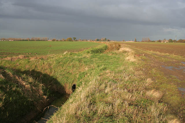
Gedney Broadgate is a small village located in the South Holland district of Lincolnshire, England. Situated approximately 10 miles east of Spalding, it lies in the flat fenland area of the county. The village is part of the civil parish of Gedney and is surrounded by agricultural land, characterized by vast fields and open countryside.

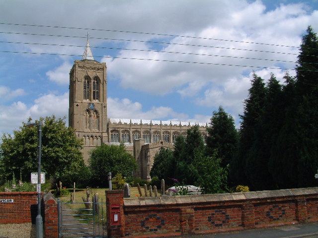
Historically, Gedney Broadgate was primarily an agricultural community, with farming being the main occupation of its inhabitants. The village has a rich history that can be traced back to medieval times, as evidenced by the presence of St. Mary Magdalene Church, which dates back to the 14th century. The church is a notable landmark in the village, known for its striking architecture and historical significance.

Despite its small size, Gedney Broadgate offers a range of amenities for its residents. These include a primary school, a village hall, a post office, and a local pub, which serves as a social hub for the community. The village is surrounded by picturesque countryside, providing opportunities for outdoor activities such as walking, cycling, and horse riding.

Gedney Broadgate is well-connected to neighboring towns and cities, with good road links to Spalding, Holbeach, and Kings Lynn. The village offers a peaceful and rural lifestyle, making it an attractive place to live for those seeking a tranquil setting away from the hustle and bustle of urban areas.

If you have any feedback on the listing, please let us know in the comments section below.

Gedney Broadgate Images

Images are sourced within 2km of 52.77506/0.075433317 or Grid Reference TF4021. Thanks to Geograph Open Source API. All images are credited.

Private farm track off Maisdyke Lane, Fleet. Looking west.
Private farm track off Maisdyke Lane, Fleet.
Looking west.
End of surfaced section of Maisdyke Lane, Fleet
Land drain, Gedney Fen, Lincolnshire Most of the drains are full after a succession of heavy late winter rains.
Land drain, Gedney Fen, Lincolnshire
Most of the drains are full after a succession of heavy late winter rains.
Fen Dike, Gedney Fen This large farm is The Fenlands. Taken from the juncntion with Ryefield Lane.
Fen Dike, Gedney Fen
This large farm is The Fenlands. Taken from the juncntion with Ryefield Lane.
Bullock's Short Gate, Gedney Fen Raven's Drove, turns into Bullock's Short Gate as it turns away from Delph Bank. Red Lodge Farm is on the left.
Bullock's Short Gate, Gedney Fen
Raven's Drove, turns into Bullock's Short Gate as it turns away from Delph Bank. Red Lodge Farm is on the left.
Fleet Fen Fleet Drain in the foreground. Photograph taken from the footpath on the east bank looking towards Maisdike Lane.
Fleet Fen
Fleet Drain in the foreground. Photograph taken from the footpath on the east bank looking towards Maisdike Lane.
Sunlit Fens Looking along the footpath towards Pinstock Lane and dark rain clouds. Fleet Drain runs through the centre and is the boundary between Fleet Fen on the left and Gedney Fen on the right.
Sunlit Fens
Looking along the footpath towards Pinstock Lane and dark rain clouds. Fleet Drain runs through the centre and is the boundary between Fleet Fen on the left and Gedney Fen on the right.
Fleet Fen Looking across the Fen from the public footpath alongside Fleet Drain.
Fleet Fen
Looking across the Fen from the public footpath alongside Fleet Drain.
Fleet Drain Fleet Fen to the right and Gedney Fen to the left. The pylons are in <a href="https://www.geograph.org.uk/gridref/TF3721">TF3721</a>, <a href="https://www.geograph.org.uk/gridref/TF3821">TF3821</a> and <a href="https://www.geograph.org.uk/gridref/TF3920">TF3920</a>.
Fleet Drain
Fleet Fen to the right and Gedney Fen to the left. The pylons are in TF3721, TF3821 and TF3920.
Fleet Fen on Delph Bank This drain must be pretty old as it does tend to meander through the farmland rather than take the usual straight course. It forms the boundary between Fleet Fen on the left with Gedney Fen on the right and forms part of the system that drains into South Holland Main Drain. This in turn flows into the River Nene. This view is looking upstream.
Fleet Fen on Delph Bank
This drain must be pretty old as it does tend to meander through the farmland rather than take the usual straight course. It forms the boundary between Fleet Fen on the left with Gedney Fen on the right and forms part of the system that drains into South Holland Main Drain. This in turn flows into the River Nene. This view is looking upstream.
Gedney Fen Looking across from Fleet Drain to Harford Gate, the road to Gedney Broadgate.
Gedney Fen
Looking across from Fleet Drain to Harford Gate, the road to Gedney Broadgate.
Fleet Fen With Fleet Drain in the foreground.
Fleet Fen
With Fleet Drain in the foreground.
Fleet Drain The bridge carries the footpath over The Fleet River, (really a drain), which joins Fleet Drain here. View looking north towards Fleet Hargate, (<a href="https://www.geograph.org.uk/gridref/TF+3024">TF 3024</a>), with Fleet Fen on the left and Gedney Fen on the right.
Fleet Drain
The bridge carries the footpath over The Fleet River, (really a drain), which joins Fleet Drain here. View looking north towards Fleet Hargate, (TF 3024), with Fleet Fen on the left and Gedney Fen on the right.
Fleet Drain An unusual sight in the Fens, a hedge!
Fleet Drain
An unusual sight in the Fens, a hedge!
Gedney Fen Looking towards Gedney Broadgate.
This drain take a couple of right angled turns in the middle distance. Its route can be followed by the dry reeds.
Gedney Fen
Looking towards Gedney Broadgate. This drain take a couple of right angled turns in the middle distance. Its route can be followed by the dry reeds.
Fleet Fen This subsidiary drain was flowing from Maisdike Lane into Fleet Drain through a culvert under the farm track on the eastern bank.
Fleet Fen
This subsidiary drain was flowing from Maisdike Lane into Fleet Drain through a culvert under the farm track on the eastern bank.
Culvert on Fleet Drain Just south of the boundary with <a href="https://www.geograph.org.uk/gridref/TF3923">TF3923</a> this culvert allows the farm track to cross Fleet Drain.
Culvert on Fleet Drain
Just south of the boundary with TF3923 this culvert allows the farm track to cross Fleet Drain.
Gedney Fen View from Fleet Drain towards Gedney Broadgate
Gedney Fen
View from Fleet Drain towards Gedney Broadgate
Show me another place!

Gedney Broadgate is located at Grid Ref: TF4021 (Lat: 52.77506, Lng: 0.075433317)

Division: Parts of Holland

Administrative County: Lincolnshire

District: South Holland

Police Authority: Lincolnshire

What 3 Words

///waitress.agreeable.frown. Near Fleet, Lincolnshire

Nearby Locations

Gedney Broadgate

Related Wikis

Gedney Broadgate

Gedney Broadgate is a hamlet in the civil parish of Gedney and the South Holland district of Lincolnshire, England. It is situated west from the A17 road...

Fleet, Lincolnshire

Fleet is a village, civil parish and electoral ward in the South Holland district of Lincolnshire, England. It lies on Delph Bank, 3 miles (4.8 km) south...

Gedney railway station

Gedney railway station was a station in Gedney, Lincolnshire. It was a station on the Midland and Great Northern Joint Railway network. It opened on 1...

Gedney, Lincolnshire

Gedney is a village, civil parish and electoral ward in the South Holland district of Lincolnshire, England. It is just to the south of the A17 Boston...

St Mary Magdalene Church, Gedney

St Mary Magdalene Church is an Anglican parish church of medieval origin in Gedney, Lincolnshire. Renowned for its large size in the surrounding low-lying...

Fleet railway station (Lincolnshire)

Fleet railway station was a station in Fleet, Lincolnshire. It opened in 1862 and closed to passengers in 1959, with the goods yard closing on 3 February...

Long Sutton railway station

Long Sutton railway station was a station in Long Sutton, Lincolnshire, England. It was part of the Midland and Great Northern Joint Railway which closed...

Low Fulney

Low Fulney is a hamlet in the South Holland district of Lincolnshire, England. It is in the Spalding St. Paul's ward of the South Holland District Council...

Nearby Amenities

Located within 500m of 52.77506,0.075433317
Post Box
Collection Times: Mo-Fr 10:00; Sa 10:00
Description: /Bullocks Shortgate / Cades Drove / Harford Gate//In wall at N end of brick barn, next to telegraph post, where it joins the garden wall of adjacent house, "Pulvertoft Hall".
Fixme: Again, not convinced this junction pos is correct.
Post Box Type: wall
Ref: PE12 46
Lat/Long: 52.774952/0.075252
Plumtree House
Place: isolated_dwelling
Source: Bing
Lat/Long: 52.777428/0.0777151
Pulvertoft Cottage
Place: isolated_dwelling
Source: Bing
Lat/Long: 52.7764453/0.0766724
Pulvertoft Hall Farm
Place: farm
Source: Bing
Lat/Long: 52.7752966/0.0751906
Teasel Cottage
Place: isolated_dwelling
Source: Bing
Lat/Long: 52.7729897/0.0717922
Broadgate Nurseries
Place: farm
Source: Bing
Lat/Long: 52.7730652/0.0747913
Haveril House
Place: isolated_dwelling
Source: Bing
Lat/Long: 52.7745792/0.0766133
Give Way
Direction: forward
Lat/Long: 52.7730727/0.0816853
Give Way
Direction: backward
Lat/Long: 52.7731579/0.08157
Give Way
Direction: forward
Lat/Long: 52.7732017/0.0816692
The data included in this document is from www.openstreetmap.org. The data is made available under ODbL.

Have you been to Gedney Broadgate?

Leave your review of Gedney Broadgate below (or comments, questions and feedback).