Crowlink

Settlement in Sussex Wealden

England

Crowlink

Official designations relating to the Birling Gap area, East Sussex Seaford and Beachy Head are approximately 7 miles distant from each other with Birling Gap lying between the two and somewhat nearer to Beachy Head. The coast at Birling Gap is shown in the accompanying photo and it is particularly famed as a site for the study of periglacial landforms and for its rapid rate of coastal erosion which equates to about 60cm / year.
The coastline between Seaford and Beachy Head, which includes the Seven Sisters, has long been recognised as an outstanding stretch of chalk cliff coast and estuarine river mouth. In response to that perceived beauty and its undeveloped nature, it has been recognised in various pieces of legislation. Since 1953, the area has been designated as a Site of Special Scientific Interest (SSSI) for its wildlife and geology; its 1966 designation as an Area of Outstanding Natural Beauty (ANOB) was replaced by becoming part of the South Downs National Park (SDNP) in 2010 and the iconic stretch of coast between Eastbourne and Splash Point in Seaford became the UK’s first Heritage Coast in 1973. Other noteworthy sites include the Seven Sisters Country Park, which since 30th July 2021has been under the ownership of the South Downs National Park Authority and the coast at Hope Gap which is a Geological Conservation Review (GCR) site.
Official designations relating to the Birling Gap area, East Sussex Credit: Andrew Diack

Crowlink is a picturesque hamlet located in the South Downs National Park, East Sussex, England. Situated on the southern slope of the downs, it offers stunning panoramic views of the English Channel and the surrounding countryside.

The area is known for its tranquil and unspoiled beauty, attracting nature enthusiasts and hikers alike. Crowlink is home to a diverse range of wildlife, including rare bird species, such as the skylark, as well as various butterflies and plants. The rolling hills and cliffs provide an ideal habitat for these creatures, making it a popular spot for birdwatching.

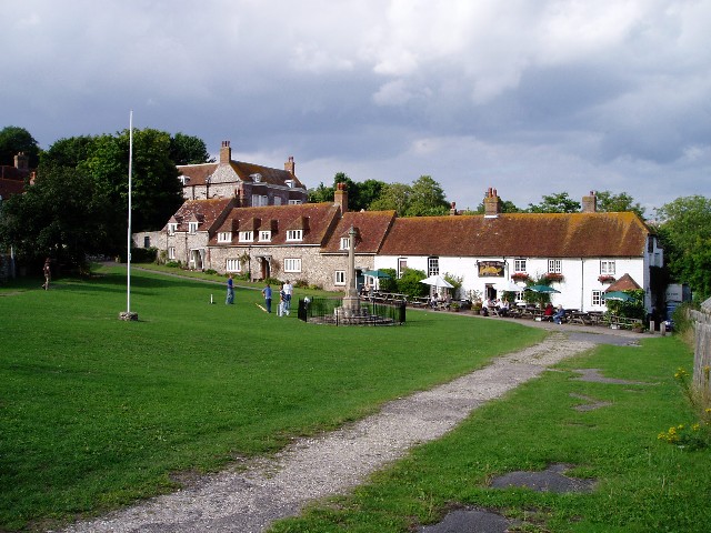
The hamlet itself consists of a handful of traditional cottages and farmhouses, giving it a charming and rustic feel. Many of these buildings date back several centuries, adding to the area's historical significance. The local community is small but tight-knit, with a strong sense of pride in the preservation of their natural surroundings.

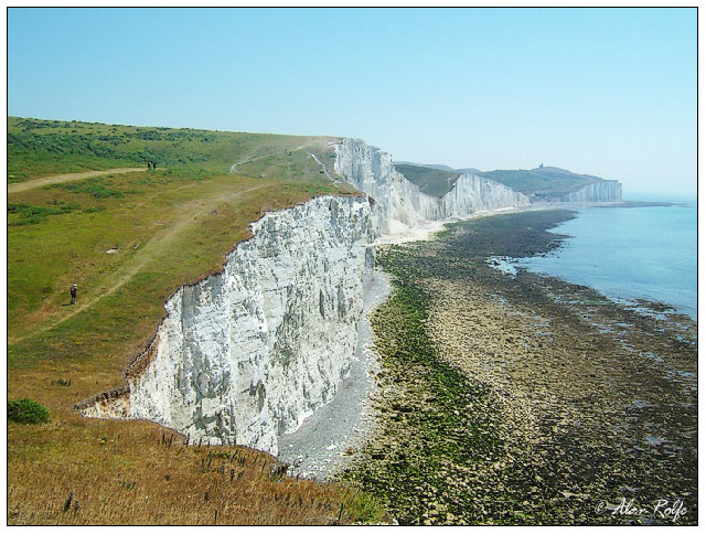
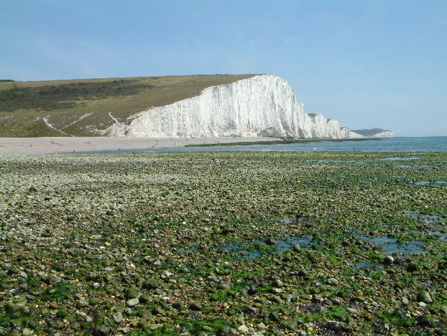
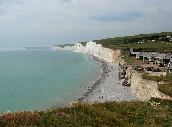
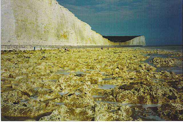
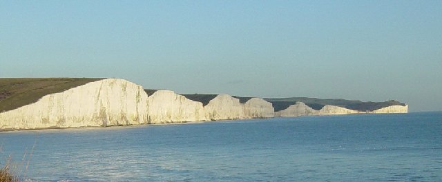
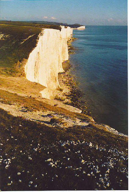
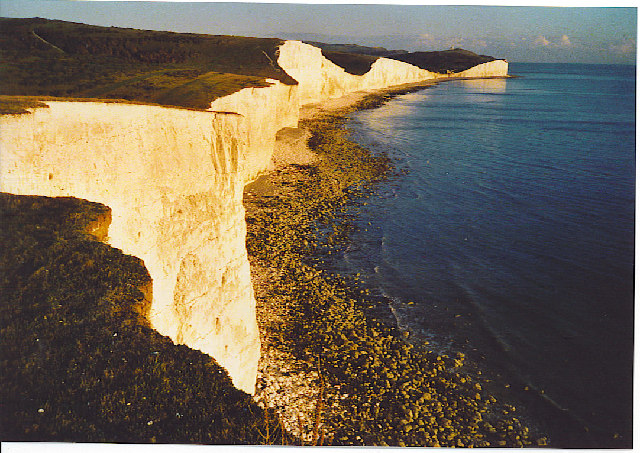
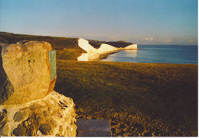
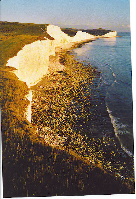
Crowlink is also renowned for its extensive network of walking trails, offering visitors the opportunity to explore the stunning landscape at their own pace. The iconic Seven Sisters cliffs, a series of chalk cliffs, are a prominent feature of the area and provide breathtaking views of the coastline. Additionally, the nearby Belle Tout lighthouse, a Victorian landmark, adds to the charm of the region.

Overall, Crowlink is a hidden gem in Sussex, offering visitors a chance to escape the hustle and bustle of modern life and immerse themselves in the beauty of nature. Whether it's admiring the stunning views, spotting rare wildlife, or exploring the historic trails, Crowlink provides an unforgettable experience for all who visit.

If you have any feedback on the listing, please let us know in the comments section below.

Crowlink Images

Images are sourced within 2km of 50.756752/0.1886543 or Grid Reference TV5497. Thanks to Geograph Open Source API. All images are credited.

Official designations relating to the Birling Gap area, East Sussex Seaford and Beachy Head are approximately 7 miles distant from each other with Birling Gap lying between the two and somewhat nearer to Beachy Head. The coast at Birling Gap is shown in the accompanying photo and it is particularly famed as a site for the study of periglacial landforms and for its rapid rate of coastal erosion which equates to about 60cm / year.
The coastline between Seaford and Beachy Head, which includes the Seven Sisters, has long been recognised as an outstanding stretch of chalk cliff coast and estuarine river mouth. In response to that perceived beauty and its undeveloped nature, it has been recognised in various pieces of legislation. Since 1953, the area has been designated as a Site of Special Scientific Interest (SSSI) for its wildlife and geology; its 1966 designation as an Area of Outstanding Natural Beauty (ANOB) was replaced by becoming part of the South Downs National Park (SDNP) in 2010 and the iconic stretch of coast between Eastbourne and Splash Point in Seaford became the UK’s first Heritage Coast in 1973. Other noteworthy sites include the Seven Sisters Country Park, which since 30th July 2021has been under the ownership of the South Downs National Park Authority and the coast at Hope Gap which is a Geological Conservation Review (GCR) site.
Official designations relating to the Birling Gap area, East Sussex
Seaford and Beachy Head are approximately 7 miles distant from each other with Birling Gap lying between the two and somewhat nearer to Beachy Head. The coast at Birling Gap is shown in the accompanying photo and it is particularly famed as a site for the study of periglacial landforms and for its rapid rate of coastal erosion which equates to about 60cm / year. The coastline between Seaford and Beachy Head, which includes the Seven Sisters, has long been recognised as an outstanding stretch of chalk cliff coast and estuarine river mouth. In response to that perceived beauty and its undeveloped nature, it has been recognised in various pieces of legislation. Since 1953, the area has been designated as a Site of Special Scientific Interest (SSSI) for its wildlife and geology; its 1966 designation as an Area of Outstanding Natural Beauty (ANOB) was replaced by becoming part of the South Downs National Park (SDNP) in 2010 and the iconic stretch of coast between Eastbourne and Splash Point in Seaford became the UK’s first Heritage Coast in 1973. Other noteworthy sites include the Seven Sisters Country Park, which since 30th July 2021has been under the ownership of the South Downs National Park Authority and the coast at Hope Gap which is a Geological Conservation Review (GCR) site.
Demolition of the former National Trust café, Birling Gap, East Sussex The photo shows work beginning on the mechanised demolition of the former National Trust café at Birling Gap in East Sussex. This work starts the removal of the landmark building from the iconic landscape of which it has been a part since the time of its construction in 1878 – 1909.  The demolition of the much loved café has been made necessary because of the rapid rate of coastal erosion with the result that the café is now only 5 yards from the cliff edge. A National Trust spokesperson has said that “The section of building, nearest the cliff edge, is being taken down to ensure we keep visitors safe and continue to adapt to the changing coastline.”
Demolition of the former National Trust café, Birling Gap, East Sussex
The photo shows work beginning on the mechanised demolition of the former National Trust café at Birling Gap in East Sussex. This work starts the removal of the landmark building from the iconic landscape of which it has been a part since the time of its construction in 1878 – 1909. The demolition of the much loved café has been made necessary because of the rapid rate of coastal erosion with the result that the café is now only 5 yards from the cliff edge. A National Trust spokesperson has said that “The section of building, nearest the cliff edge, is being taken down to ensure we keep visitors safe and continue to adapt to the changing coastline.”
Heading east off the Seven Sisters into Birling Gap
Michel Dean monument In the last dip on the Seven Sisters before Birling Gap. The monument is mark the gift of the land to the National Trust.
Michel Dean monument
In the last dip on the Seven Sisters before Birling Gap. The monument is mark the gift of the land to the National Trust.
On the Seven Sisters looking east The old lighthouse of Belle Tout can be seen right on the distant cliff. This was moved some 16 metres or so back from the cliff edge in 1999 and may have to be moved again within the next 50 years.
On the Seven Sisters looking east
The old lighthouse of Belle Tout can be seen right on the distant cliff. This was moved some 16 metres or so back from the cliff edge in 1999 and may have to be moved again within the next 50 years.
Cliff End, E side of Cuckmere Haven Cuckmere Haven lies on the coast at the point where the South Downs meet the sea. Cliff End marks the western end of the famous Seven Sisters chalk cliffs.
Cliff End, E side of Cuckmere Haven
Cuckmere Haven lies on the coast at the point where the South Downs meet the sea. Cliff End marks the western end of the famous Seven Sisters chalk cliffs.
East Dean village green An impromptu game of cricket being played outside the Tiger Inn
East Dean village green
An impromptu game of cricket being played outside the Tiger Inn
Friston church I quite like this lych-gate.  The footpath to East Dean passes through it and the churchyard.
Friston church
I quite like this lych-gate. The footpath to East Dean passes through it and the churchyard.
Birling Gap This image taken in 2001 shows how precarious the houses are.  I wonder whether they are still there? Some of them are still there, up to the one painted cream but the other two have gone. <a href="https://www.geograph.org.uk/photo/4128405">TV5595 : Former Coastguard  Cottages, Birling Gap, Sussex</a> for how it looks now.
Birling Gap
This image taken in 2001 shows how precarious the houses are. I wonder whether they are still there? Some of them are still there, up to the one painted cream but the other two have gone. TV5595 : Former Coastguard Cottages, Birling Gap, Sussex for how it looks now.
Birling Gap Birling Gap hotel, beach and lifeboat, facing to the west.
Birling Gap
Birling Gap hotel, beach and lifeboat, facing to the west.
Eroding Chalk cliffs at Birling Gap One of the most unusual accesses to a beach you'll find!
Eroding Chalk cliffs at Birling Gap
One of the most unusual accesses to a beach you'll find!
The Seven Sisters - Foreshore at Low Tide Below towering chalk-white cliffs is an eroded chalk foreshore pavement at low tide. The trapped seawater is milky white too. In the distance, the dip in the cliffline is Birling Gap.
The Seven Sisters - Foreshore at Low Tide
Below towering chalk-white cliffs is an eroded chalk foreshore pavement at low tide. The trapped seawater is milky white too. In the distance, the dip in the cliffline is Birling Gap.
The Seven Sisters The nearest chalk cliff is just to the east of Cuckmere Haven in square TV5297. The Seven Sisters extend eastwards to Birling Gap in square TV5595.
The Seven Sisters
The nearest chalk cliff is just to the east of Cuckmere Haven in square TV5297. The Seven Sisters extend eastwards to Birling Gap in square TV5595.
The Seven Sisters from Cliff End. Looking east towards Birling Gap. The cliff face is steadily moving inland as marine undercutting erodes the soft chalk.
The Seven Sisters from Cliff End.
Looking east towards Birling Gap. The cliff face is steadily moving inland as marine undercutting erodes the soft chalk.
Nearly High Tide at Crowlink, Seven Sisters. Chalk cliffs undergoing steady erosion.
Nearly High Tide at Crowlink, Seven Sisters.
Chalk cliffs undergoing steady erosion.
Monument at Crowlink, Seven Sisters. William Charles Campbell Monument on the South Downs Way, overlooking chalk cliffs.
Monument at Crowlink, Seven Sisters.
William Charles Campbell Monument on the South Downs Way, overlooking chalk cliffs.
Seven Sisters and Foreshore. Taken from near Crowlink, looking towards Birling Gap.
Seven Sisters and Foreshore.
Taken from near Crowlink, looking towards Birling Gap.
Old Water Tower, Friston Taken from Willingdon Road looking South East.
Old Water Tower, Friston
Taken from Willingdon Road looking South East.
Show me another place!

Crowlink is located at Grid Ref: TV5497 (Lat: 50.756752, Lng: 0.1886543)

Administrative County: East Sussex

District: Wealden

Police Authority: Sussex

What 3 Words

///gearing.mows.revisits. Near Friston, East Sussex

Nearby Locations

Crowlink

Related Wikis

Seaford to Beachy Head

Seaford to Beachy Head is a 1,108.7-hectare (2,740-acre) biological and geological Site of Special Scientific Interest which stretches from Seaford to...

East Dean and Friston

East Dean and Friston is a civil parish in the Wealden District of East Sussex, England.The two villages in the parish are in a dry valley on the South...

Seven Sisters Sheep Centre

The Seven Sisters Sheep Centre was a farm near East Dean, in the Seven Sisters Country Park of the South Downs. It held a large collection of about 50...

RAF Friston

Royal Air Force Friston or more simply RAF Friston is a former Royal Air Force satellite station and Emergency Landing Ground located in East Sussex, England...

Nearby Amenities

Located within 500m of 50.756752,0.1886543
Post Box
Collection Times: Mo-Fr 09:00; Sa 07:00
Operator: Royal Mail
Post Box Type: lamp
Ref: BN20 708D
Royal Cypher: EIIR
Royal Cypher Wikidata: Q33102113
Lat/Long: 50.7572489/0.189952
Barrier: kissing_gate
Foot: yes
Lat/Long: 50.7540926/0.185554
Fixme: continue
Lat/Long: 50.7568835/0.1894305
Addr Housename: Crowlink End
Addr Street: Crowlink Lane
Lat/Long: 50.7562285/0.1870377
The data included in this document is from www.openstreetmap.org. The data is made available under ODbL.

Have you been to Crowlink?

Leave your review of Crowlink below (or comments, questions and feedback).