Churchtown

Settlement in Cornwall

England

Churchtown

Fishing from Gam Bridge The bridge spans the River Camel.
Fishing from Gam Bridge Credit: John Baker

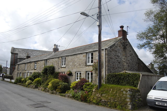
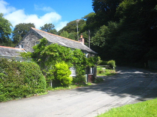
Churchtown is a small village located in the county of Cornwall, England. Situated on the southwestern tip of the country, it is nestled in a picturesque setting, surrounded by rolling hills and lush green countryside. The village is known for its charming and quaint atmosphere, attracting tourists and locals alike.

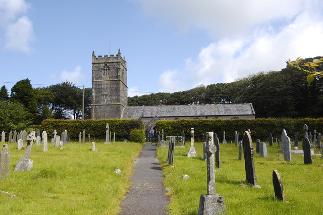
One of the most notable landmarks in Churchtown is its historic church, which dates back to the 12th century. This beautiful stone building stands proudly in the heart of the village, serving as a symbol of the area's rich heritage. The church is open to visitors, allowing them to admire its stunning architecture and explore its interior, which is adorned with intricate stained glass windows and ancient artifacts.

In addition to its historical significance, Churchtown offers a range of amenities for residents and visitors. The village boasts a selection of cozy pubs and welcoming tea rooms, where visitors can sample traditional Cornish cuisine and indulge in a cup of locally brewed tea. There are also several shops selling locally made crafts and souvenirs, providing an opportunity to take a piece of Churchtown home.

Nature enthusiasts will find plenty to explore in the surrounding area, with numerous walking trails and scenic viewpoints. The village is located just a short distance from the stunning Cornish coastline, allowing visitors to enjoy sandy beaches, rugged cliffs, and panoramic sea views.

Overall, Churchtown is a charming village that offers a glimpse into Cornwall's rich history and natural beauty. With its warm hospitality and idyllic setting, it is a must-visit destination for anyone seeking a tranquil escape in the heart of the English countryside.

If you have any feedback on the listing, please let us know in the comments section below.

Churchtown Images

Images are sourced within 2km of 50.563075/-4.6863382 or Grid Reference SX0977. Thanks to Geograph Open Source API. All images are credited.

Fishing from Gam Bridge The bridge spans the River Camel.
Fishing from Gam Bridge
The bridge spans the River Camel.
North Cornwall : The B3266 The B3266 near Trevenning in North Cornwall.
North Cornwall : The B3266
The B3266 near Trevenning in North Cornwall.
Hengar Manor House, St Tudy
St Breward Methodist Church Dating from as recently as 1957, replacing the chapel destroyed in World War II by a German bomb (see: <span class="nowrap"><a title="http://www.bbc.co.uk/history/ww2peopleswar/stories/31/a8346431.shtml" rel="nofollow ugc noopener" href="http://www.bbc.co.uk/history/ww2peopleswar/stories/31/a8346431.shtml">Link</a><img style="margin-left:2px;" alt="External link" title="External link - shift click to open in new window" src="https://s1.geograph.org.uk/img/external.png" width="10" height="10"/></span> ).
St Breward Methodist Church
Dating from as recently as 1957, replacing the chapel destroyed in World War II by a German bomb (see: LinkExternal link ).
Terraced cottages, St Breward For a comprehensive description of the history and architecture of Cornwall's highest village, see: <span class="nowrap"><a title="http://www.historic-cornwall.org.uk/cisi/st_breward/cisi_st_breward_report.pdf" rel="nofollow ugc noopener" href="http://www.historic-cornwall.org.uk/cisi/st_breward/cisi_st_breward_report.pdf">Link</a><img style="margin-left:2px;" alt="External link" title="External link - shift click to open in new window" src="https://s1.geograph.org.uk/img/external.png" width="10" height="10"/></span>
Terraced cottages, St Breward
For a comprehensive description of the history and architecture of Cornwall's highest village, see: LinkExternal link
St Breward Primary School Built 1930.  The granite was probably quarried in the village.
St Breward Primary School
Built 1930. The granite was probably quarried in the village.
St Brueredus Church, St Breward Grade I listed: <span class="nowrap"><a title="http://www.britishlistedbuildings.co.uk/en-67459-church-of-st-brueredus-st-breward" rel="nofollow ugc noopener" href="http://www.britishlistedbuildings.co.uk/en-67459-church-of-st-brueredus-st-breward">Link</a><img style="margin-left:2px;" alt="External link" title="External link - shift click to open in new window" src="https://s1.geograph.org.uk/img/external.png" width="10" height="10"/></span>
St Brueredus Church, St Breward
Grade I listed: LinkExternal link
St Breward war memorial A modern structure in a rather unusual location on the moorland just outside the village.
St Breward war memorial
A modern structure in a rather unusual location on the moorland just outside the village.
House at Gam Bridge in the Camel valley
Entrance drive to Fellover Fellover School is noted on the OS map but it seems it closed on 31 July 1990.
Entrance drive to Fellover
Fellover School is noted on the OS map but it seems it closed on 31 July 1990.
Ordnance Survey Cut Mark This OS cut mark can be found on the west face of the church of St Bruerdus. It marks a point 214.798m above mean sea level.
Ordnance Survey Cut Mark
This OS cut mark can be found on the west face of the church of St Bruerdus. It marks a point 214.798m above mean sea level.
Old Boundary Marker on Lady Down, St Breward parish Estate Boundary Marker on the lane to St Breward and Higher Lank, adjacent to the cattle grid at the western edge of Lady Down. St Breward parish.

This stone appears to mark the western limit of Lady Down. Tithe records show that Lady Down was owned by the Manor of Blisland, which was held by the Molesworth family and whose mark M X can be seen on the stone’s eastern face.

Milestone Society National ID: CW_BREWAR19em
Old Boundary Marker on Lady Down, St Breward parish
Estate Boundary Marker on the lane to St Breward and Higher Lank, adjacent to the cattle grid at the western edge of Lady Down. St Breward parish. This stone appears to mark the western limit of Lady Down. Tithe records show that Lady Down was owned by the Manor of Blisland, which was held by the Molesworth family and whose mark M X can be seen on the stone’s eastern face. Milestone Society National ID: CW_BREWAR19em
Old Boundary Marker on Lady Down, St Breward parish Estate Boundary Marker near a cottage gate against the stone wall at the northwest edge of Lady Down. St Breward parish.

This stone appears to mark the north western boundary of Lady Down and the enclosed farmland of Hallagenna Farm. Tithe records show that Lady Down was owned by the Manor of Blisland, which was held by the Molesworth family and whose mark M X can be seen on the stone’s eastern face.

Milestone Society National ID: CW_BREWAR20em
Old Boundary Marker on Lady Down, St Breward parish
Estate Boundary Marker near a cottage gate against the stone wall at the northwest edge of Lady Down. St Breward parish. This stone appears to mark the north western boundary of Lady Down and the enclosed farmland of Hallagenna Farm. Tithe records show that Lady Down was owned by the Manor of Blisland, which was held by the Molesworth family and whose mark M X can be seen on the stone’s eastern face. Milestone Society National ID: CW_BREWAR20em
Old Boundary Marker on Lady Down, St Breward parish Estate Boundary Marker close to the lane to St Breward and Higher Lank on the southwest edge of Lady Down and close to a ninety-degree bend in the Cornish hedge that forms the southern boundary of Lady Down. St Breward parish.

This stone appears to mark the northern boundary of a small rectangular piece of Lady Down that was under different ownership of the majority of the downs. The northern face of the stone is marked M but other faces of the stone are unmarked. M was the mark of the Molesworth family, who owned Lady Down.

Milestone Society National ID: CW_BREWAR21em
Old Boundary Marker on Lady Down, St Breward parish
Estate Boundary Marker close to the lane to St Breward and Higher Lank on the southwest edge of Lady Down and close to a ninety-degree bend in the Cornish hedge that forms the southern boundary of Lady Down. St Breward parish. This stone appears to mark the northern boundary of a small rectangular piece of Lady Down that was under different ownership of the majority of the downs. The northern face of the stone is marked M but other faces of the stone are unmarked. M was the mark of the Molesworth family, who owned Lady Down. Milestone Society National ID: CW_BREWAR21em
Old Boundary Marker on Lady Down, St Breward parish Estate Boundary Marker on the southwest edge of Lady Down at the junction of the lanes to St Breward and Higher Lank, and to Hantergantic. St Breward parish.

This stone appears to mark the northern boundary of a small rectangular piece of Lady Down that was under different ownership of the majority of the downs. The northern face of the stone is marked M but other faces of the stone are unmarked. M was the mark of the Molesworth family, who owned Lady Down

Milestone Society National ID: CW_BREWAR22em
Old Boundary Marker on Lady Down, St Breward parish
Estate Boundary Marker on the southwest edge of Lady Down at the junction of the lanes to St Breward and Higher Lank, and to Hantergantic. St Breward parish. This stone appears to mark the northern boundary of a small rectangular piece of Lady Down that was under different ownership of the majority of the downs. The northern face of the stone is marked M but other faces of the stone are unmarked. M was the mark of the Molesworth family, who owned Lady Down Milestone Society National ID: CW_BREWAR22em
Lady Down, St Breward Grazing here for centuries
Lady Down, St Breward
Grazing here for centuries
Moorland inhabitant I had stopped on my bike to take a picture of this cow, which seemed very friendly. While I was doing this a car approached along the road. The mother, obviously thinking that I was about to be gored to death and not wanting her children to witness such a scene, told the children to look away, while father drove off at high speed!
Moorland inhabitant
I had stopped on my bike to take a picture of this cow, which seemed very friendly. While I was doing this a car approached along the road. The mother, obviously thinking that I was about to be gored to death and not wanting her children to witness such a scene, told the children to look away, while father drove off at high speed!
The Manor House at Hengar Manor Now converted into holiday apartments and restaurant, this manor house is the centrepiece of a holiday and leisure complex to which it gives its name.
The Manor House at Hengar Manor
Now converted into holiday apartments and restaurant, this manor house is the centrepiece of a holiday and leisure complex to which it gives its name.
Show me another place!

Churchtown is located at Grid Ref: SX0977 (Lat: 50.563075, Lng: -4.6863382)

Unitary Authority: Cornwall

Police Authority: Devon and Cornwall

What 3 Words

///jiffy.scouts.inflates. Near Camelford, Cornwall

Nearby Locations

Churchtown Tuckingmill

Related Wikis

St Breward

St Breward (Cornish: S. Bruwerd) is a civil parish and village in Cornwall, England, United Kingdom. It is on the western side of Bodmin Moor, about 6...

Tuckingmill, St Breward, Cornwall

Tuckingmill is a small hamlet near St Breward, Cornwall. It is located within the parish of St. Breward. It contains a number of properties including a...

Gam, Cornwall

Gam is a hamlet in the parish of St Breward (where the 2011 census population is included), Cornwall, England. == References ==

Fentonadle

Fentonadle is a hamlet situated 4 miles (6.4 km) south-west from Camelford in Cornwall, England. Fentonadle lies at around 120 metres (390 ft) above sea...

Nearby Amenities

Located within 500m of 50.563075,-4.6863382
St. Breward
Is In: Cornwall, England, UK
Is In Country: England
Is In Country Code: GB
Is In County: Cornwall
Name Kw: Sen Bruwerd
Place: village
Lat/Long: 50.5596209/-4.6884949
Post Box
Post Box Type: wall
Lat/Long: 50.565139/-4.6885211
Give Way
Lat/Long: 50.562129/-4.6861852
Post Box
Ref: PL30 150
Lat/Long: 50.561332/-4.6872102
Bus Stop
Shelter
Naptan AtcoCode: 0800COA10498
Naptan Bearing: SW
Naptan CommonName: Shelter
Naptan NaptanCode: cordmptw
Naptan Street: Rylands Terrace
Naptan Verified: no
Source: naptan_import
Lat/Long: 50.5620616/-4.6861542
Bus Stop
Old Inn
Naptan AtcoCode: 0800COA10501
Naptan Bearing: N
Naptan CommonName: Old Inn
Naptan Indicator: Opp
Naptan NaptanCode: cordmpmw
Naptan Street: Unclassified
Naptan Verified: no
Source: naptan_import
Lat/Long: 50.5641416/-4.6886527
Give Way
Lat/Long: 50.561143/-4.6872923
Give Way
Lat/Long: 50.5619731/-4.6863159
Give Way
Lat/Long: 50.5630633/-4.6863635
Give Way
Lat/Long: 50.5630031/-4.6840949
Barrier: stile
Lat/Long: 50.5653347/-4.6867222
Entrance: yes
Lat/Long: 50.5647267/-4.6880573
Give Way
Lat/Long: 50.5602932/-4.6909115
Give Way
Lat/Long: 50.5630081/-4.6842727
Barrier: stile
Lat/Long: 50.5647427/-4.6875602
Historic: memorial
Lat/Long: 50.565783/-4.6888407
Barrier: stile
Lat/Long: 50.5656921/-4.6815061
Barrier: stile
Lat/Long: 50.5657404/-4.6815716
Barrier: stile
Lat/Long: 50.5661172/-4.6830431
Barrier: stile
Lat/Long: 50.5662347/-4.6836774
Barrier: stile
Lat/Long: 50.5661802/-4.6837445
Barrier: stile
Lat/Long: 50.565963/-4.6840583
Bench
Lat/Long: 50.5612302/-4.6873896
St. Breward Stores
Shop: convenience
Lat/Long: 50.5643126/-4.6883296
Power: pole
Lat/Long: 50.5645143/-4.6817073
Power: pole
Lat/Long: 50.5657478/-4.681356
Power: pole
Lat/Long: 50.5632024/-4.6820802
Power: pole
Lat/Long: 50.5614756/-4.6826864
Power: pole
Lat/Long: 50.5597776/-4.6834347
Power: pole
Lat/Long: 50.5619585/-4.6797901
Springfield
Place: isolated_dwelling
Lat/Long: 50.5621341/-4.6804279
Power: pole
Lat/Long: 50.5616016/-4.6927755
Give Way
Lat/Long: 50.5605895/-4.6867955
The data included in this document is from www.openstreetmap.org. The data is made available under ODbL.

Have you been to Churchtown?

Leave your review of Churchtown below (or comments, questions and feedback).