Bruisyard Street

Settlement in Suffolk East Suffolk

England

Bruisyard Street

View into the Gull valley west of Sweffling
View into the Gull valley west of Sweffling Credit: Christopher Hilton

Bruisyard Street is a small village located in Suffolk, England. Situated approximately 4 miles west of the market town of Saxmundham, it is nestled in the beautiful countryside of the Suffolk Coastal Area of Outstanding Natural Beauty. The village is surrounded by picturesque rolling hills and farmland, creating a serene and idyllic setting.

With its origins dating back to medieval times, Bruisyard Street is steeped in history and boasts a number of charming period properties. The village is characterized by its quaint and peaceful atmosphere, offering a tranquil escape from the hustle and bustle of modern life.

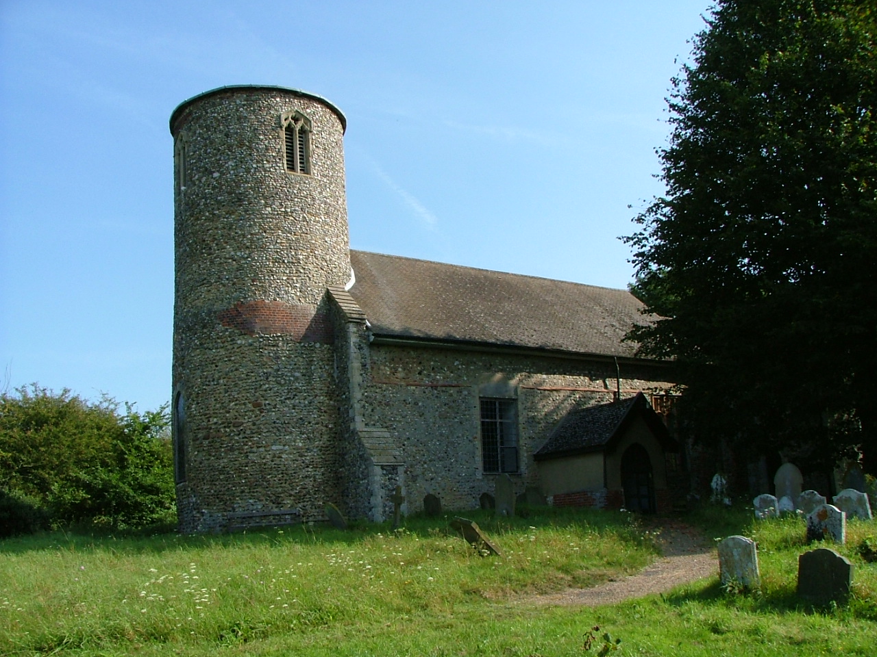
Despite its small size, Bruisyard Street has a strong sense of community. The village is home to a close-knit population who take pride in their surroundings. The parish church, St. Peter's, stands as a focal point in the village, providing a place of worship and hosting community events.

The surrounding countryside offers a range of outdoor recreational activities for residents and visitors alike. Walking and cycling routes are plentiful, allowing individuals to explore the natural beauty of the area. The nearby Bruisyard Hall, a stunning Tudor mansion, provides a venue for various events, including weddings and concerts.

While Bruisyard Street does not have its own amenities, the nearby town of Saxmundham offers a range of shops, restaurants, and services just a short drive away. Additionally, the village benefits from excellent transport links, with the A12 road providing easy access to other parts of Suffolk and beyond.

In summary, Bruisyard Street is a charming and historic village surrounded by beautiful countryside, offering a peaceful and close-knit community for its residents.

If you have any feedback on the listing, please let us know in the comments section below.

Bruisyard Street Images

Images are sourced within 2km of 52.239857/1.4178877 or Grid Reference TM3365. Thanks to Geograph Open Source API. All images are credited.

View into the Gull valley west of Sweffling
Bruisyard Road, Cransford
Track from the B1119 towards Sweffling Hall
Cransford  Village  Hall
Cransford Village Hall
Church of St. Peter, Bruisyard <span class="nowrap"><a title="https://historicengland.org.uk/listing/the-list/list-entry/1377166?section=official-list-entry" rel="nofollow ugc noopener" href="https://historicengland.org.uk/listing/the-list/list-entry/1377166?section=official-list-entry">Link</a><img style="margin-left:2px;" alt="External link" title="External link - shift click to open in new window" src="https://s1.geograph.org.uk/img/external.png" width="10" height="10"/></span>
Church of St. Peter, Bruisyard
Church of St. Michael, Rendham <span class="nowrap"><a title="https://historicengland.org.uk/listing/the-list/list-entry/1199503?section=official-list-entry" rel="nofollow ugc noopener" href="https://historicengland.org.uk/listing/the-list/list-entry/1199503?section=official-list-entry">Link</a><img style="margin-left:2px;" alt="External link" title="External link - shift click to open in new window" src="https://s1.geograph.org.uk/img/external.png" width="10" height="10"/></span>
Church of St. Michael, Rendham
Floods in the valley of the River Alde
The Rendham Congregational church War Memorial The memorial is now located in the parish church of St. Michael. This memorial bears 24 names of men lost in WW1 whereas the parish church memorial has only four names. A possible explanation for the great difference in numbers was perhaps that the rector at the time would not permit the names of men on the church memorial who did not regularly attend the church, whereas the Congregationalist minister was more sympathetic. Not an uncommon occurrence.
The Rendham Congregational church War Memorial
The memorial is now located in the parish church of St. Michael. This memorial bears 24 names of men lost in WW1 whereas the parish church memorial has only four names. A possible explanation for the great difference in numbers was perhaps that the rector at the time would not permit the names of men on the church memorial who did not regularly attend the church, whereas the Congregationalist minister was more sympathetic. Not an uncommon occurrence.
Rendham village hall
St Michael's church, Rendham Some parts of the church are C15 but it was extensively restored in 1852.
St Michael's church, Rendham
Some parts of the church are C15 but it was extensively restored in 1852.
Rendham, the White Horse pub Built in C17. See <span class="nowrap"><a title="http://www.britishlistedbuildings.co.uk/en-285696-white-horse-rendham-suffolk#.VuWd-vmLTIU" rel="nofollow ugc noopener" href="http://www.britishlistedbuildings.co.uk/en-285696-white-horse-rendham-suffolk#.VuWd-vmLTIU">Link</a><img style="margin-left:2px;" alt="External link" title="External link - shift click to open in new window" src="https://s1.geograph.org.uk/img/external.png" width="10" height="10"/></span> for entry in British Listed Buildings. The village sign can be seen on the left of the picture. See <a title="https://www.geograph.org.uk/photo/4861565" href="https://www.geograph.org.uk/photo/4861565">Link</a> for a close-up.
Rendham, the White Horse pub
Built in C17. See LinkExternal link for entry in British Listed Buildings. The village sign can be seen on the left of the picture. See Link for a close-up.
Rendham village sign The Roman-looking head at the bottom is of the Emperor Claudius. In 1907 the head of a statue of Claudius was found in the river. It was identified as having been looted from the temple in Calmulodunum (Colchester) probably in AD 60. See <span class="nowrap"><a title="http://rendham.onesuffolk.net/home/rendham-story/history-of-rendham/" rel="nofollow ugc noopener" href="http://rendham.onesuffolk.net/home/rendham-story/history-of-rendham/">Link</a><img style="margin-left:2px;" alt="External link" title="External link - shift click to open in new window" src="https://s1.geograph.org.uk/img/external.png" width="10" height="10"/></span> .
Rendham village sign
The Roman-looking head at the bottom is of the Emperor Claudius. In 1907 the head of a statue of Claudius was found in the river. It was identified as having been looted from the temple in Calmulodunum (Colchester) probably in AD 60. See LinkExternal link .
Cut Mark Bruisyard St Peters Church Cut Mark Bruisyard St Peters Church E face, SE angle.
Cut Mark Bruisyard St Peters Church
Cut Mark Bruisyard St Peters Church E face, SE angle.
Cransford Baptist Church 1987 Great Storm Memorial Stone Inscribed: Cransford Baptist Church 1st Erected 1841Destroyed By Hurricane 1987 Rebuilt To Gods Glory 1989.
Cransford Baptist Church 1987 Great Storm Memorial Stone
Inscribed: Cransford Baptist Church 1st Erected 1841Destroyed By Hurricane 1987 Rebuilt To Gods Glory 1989.
East end of St Michael's church, Rendham
Cottages in Rendham, from the churchyard
Rendham, after the rain The last rain of Storm Dennis had just stopped, and the final hour of the afternoon saw the setting sun emerge from below the clouds and illuminate the houses and St Michael's church.
Rendham, after the rain
The last rain of Storm Dennis had just stopped, and the final hour of the afternoon saw the setting sun emerge from below the clouds and illuminate the houses and St Michael's church.
Lane north of Rendham Taken in the last light of the day.
Lane north of Rendham
Taken in the last light of the day.
Show me another place!

Bruisyard Street is located at Grid Ref: TM3365 (Lat: 52.239857, Lng: 1.4178877)

Administrative County: Suffolk

District: East Suffolk

Police Authority: Suffolk

What 3 Words

///daunting.chicken.lushly. Near Saxmundham, Suffolk

Nearby Locations

Bruisyard Street

Related Wikis

Bruisyard Abbey

The Abbey of Bruisyard was a house of Minoresses (Poor Clares) at Bruisyard in Suffolk. It was founded from Campsey Priory in Suffolk on the initiative...

Bruisyard

Bruisyard is a village in the valley of the River Alde in the county of Suffolk, England. The village had a population of around 175 at the 2011 census...

Rendham

Rendham is a village and civil parish on the B1119 road, in the East Suffolk district, in the English county of Suffolk. It is near the town Saxmundham...

Cransford

Cransford is a village and a civil parish in the East Suffolk district, in the English county of Suffolk. The civil parish had a population at the 2011...

Nearby Amenities

Located within 500m of 52.239857,1.4178877
Bruisyard Street
Note: appears in property search results as well as on old maps
Place: village
Source: OS 1:25k
Verified: yes
Lat/Long: 52.240033/1.4195786
Bus Stop
Tinhouse Road
Naptan AtcoCode: 390060230
Naptan Bearing: S
Naptan BusStopType: CUS
Naptan CommonName: Tinhouse Road
Naptan Indicator: opp
Naptan Landmark: Tinhouse Road
Naptan NaptanCode: sufgpama
Naptan Street: The Street
Naptan Verified: no
Source: naptan_import
Lat/Long: 52.2418171/1.4185439
Bus Stop
Tinhouse Road
Naptan AtcoCode: 390060231
Naptan Bearing: N
Naptan BusStopType: CUS
Naptan CommonName: Tinhouse Road
Naptan Indicator: adj
Naptan Landmark: Tinhouse Road
Naptan NaptanCode: sufgpamd
Naptan Street: The Street
Naptan Verified: no
Source: naptan_import
Lat/Long: 52.2419726/1.4183512
Bus Stop
Blacksmiths Corner
Naptan AtcoCode: 390060232
Naptan Bearing: N
Naptan BusStopType: CUS
Naptan CommonName: Blacksmiths Corner
Naptan Indicator: N-bound
Naptan Landmark: Blacksmiths Corner
Naptan NaptanCode: sufgpamg
Naptan Street: Bruisyard Road
Naptan Verified: no
Source: naptan_import
Lat/Long: 52.238951/1.4174008
Bus Stop
Blacksmiths Corner
Naptan AtcoCode: 390060233
Naptan Bearing: S
Naptan BusStopType: CUS
Naptan CommonName: Blacksmiths Corner
Naptan Indicator: S-bound
Naptan Landmark: Blacksmiths Corner
Naptan NaptanCode: sufgpamj
Naptan Street: Bruisyard Road
Naptan Verified: no
Source: naptan_import
Lat/Long: 52.2387266/1.4173836
Bus Stop
Hall
Naptan AtcoCode: 390060918
Naptan Bearing: E
Naptan BusStopType: CUS
Naptan CommonName: Hall
Naptan Indicator: adj
Naptan Landmark: Hall
Naptan NaptanCode: sufjmagd
Naptan Street: Tinhouse Road
Naptan Verified: no
Source: naptan_import
Lat/Long: 52.242658/1.4162908
Bus Stop
Hall
Naptan AtcoCode: 390060919
Naptan Bearing: W
Naptan BusStopType: CUS
Naptan CommonName: Hall
Naptan Indicator: opp
Naptan Landmark: Hall
Naptan NaptanCode: sufjmagj
Naptan Street: Tinhouse Road
Naptan Verified: no
Source: naptan_import
Lat/Long: 52.2425058/1.4160918
Bus Stop
The Street
Naptan AtcoCode: 390060920
Naptan Bearing: E
Naptan BusStopType: CUS
Naptan CommonName: The Street
Naptan Indicator: adj
Naptan Landmark: The Street
Naptan NaptanCode: sufjmagm
Naptan Street: Rendham Road
Naptan Verified: no
Source: naptan_import
Lat/Long: 52.2393687/1.4200555
Bus Stop
The Street
Naptan AtcoCode: 390060921
Naptan Bearing: W
Naptan BusStopType: CUS
Naptan CommonName: The Street
Naptan Indicator: opp
Naptan Landmark: The Street
Naptan NaptanCode: sufjmagp
Naptan Street: Rendham Road
Naptan Verified: no
Source: naptan_import
Lat/Long: 52.2392593/1.4201057
Power: pole
Lat/Long: 52.235481/1.4192858
Power: pole
Lat/Long: 52.2365669/1.4198139
Power: pole
Lat/Long: 52.2391572/1.4210558
Power: pole
Lat/Long: 52.2423369/1.4226249
Power: pole
Lat/Long: 52.2404317/1.4216888
Post Box
Collection Times: Mo-Fr 16:00; Sa 10:00
Operator: Royal Mail
Post Box Type: lamp
Ref: IP17 4649
Royal Cypher: EIIR
Royal Cypher Wikidata: Q33102113
Lat/Long: 52.2408094/1.4175593
The data included in this document is from www.openstreetmap.org. The data is made available under ODbL.

Have you been to Bruisyard Street?

Leave your review of Bruisyard Street below (or comments, questions and feedback).