Braunstone

Settlement in Leicestershire

England

Braunstone

Braunstone is a suburb located in the western part of Leicester, Leicestershire, England. It is situated around 3.5 miles from the city center and is bordered by the neighborhoods of Western Park, Rowley Fields, and Glenfield. Historically, Braunstone was a rural village, but it transformed into a residential area in the mid-20th century due to an increase in housing demand.

The suburb is known for its diverse community and offers a range of amenities for its residents. It is home to the famous Braunstone Park, a large public park spanning approximately 198 acres. The park features beautiful gardens, woodlands, and a large lake, providing a serene environment for leisurely walks, picnics, and other outdoor activities. Additionally, there are various sports facilities within the park, including football pitches, a cricket field, and a children's play area.

Braunstone also offers a range of shopping facilities to cater to the needs of its residents. The main shopping center, known as the Braunstone Crossroads, is home to several supermarkets, local shops, and a variety of eateries. The suburb is well-connected to the city center and surrounding areas by an efficient bus network, ensuring easy accessibility for both residents and commuters.

In terms of education, Braunstone has several primary schools and a secondary school, providing quality education to the local community. There are also various community centers, healthcare facilities, and religious institutions that serve the diverse population.

Overall, Braunstone is a vibrant and diverse suburb in Leicestershire, offering a range of amenities, green spaces, and a strong sense of community.

If you have any feedback on the listing, please let us know in the comments section below.

Braunstone is located at Grid Ref: SK5502 (Lat: 52.619309, Lng: -1.1811601)

Unitary Authority: Leicester

Police Authority: Leicestershire

What 3 Words

///finest.glare.spike. Near Glenfield, Leicestershire

Related Wikis

The Winstanley School

The Winstanley School is a coeducational secondary school located in Braunstone in the English county of Leicestershire. The school specialises in sports...

Braunstone Town

Braunstone is a town and civil parish in the district of Blaby in Leicestershire, England. At the 2011 census the population of the town was 16,850. Braunstone...
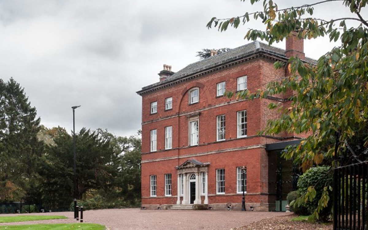
Winstanley House

Winstanley House in Leicestershire previously called Braunstone Hall, is a building of historical significance and is Grade II listed on the English Heritage...

Emmanuel Christian School, Leicester

Emmanuel Christian School, Leicester, is a small, independent, co-educational Christian school for pupils aged 4–16. Opening on 28 August 2003, it was...

Nearby Amenities

Located within 500m of 52.619309,-1.1811601
Braunstone Town
Is In County: Leicestershire
Is In District: Blaby
Place: village
Wikidata: Q4383696
Wikipedia: en:Braunstone Town
Lat/Long: 52.615963/-1.1826524
Traffic Calming: chicane
Lat/Long: 52.623603/-1.1816955
Mini Roundabout
Direction: clockwise
Lat/Long: 52.6180504/-1.1774121
Mini Roundabout
Direction: clockwise
Lat/Long: 52.6179404/-1.1747955
Police
Braunstone Police Station
Created By: Potlatch 0.10f
Lat/Long: 52.6183908/-1.1757806
Place Of Worship
Friar Lane and Braunstone Baptist Church
Denomination: baptist
Religion: christian
Lat/Long: 52.6186969/-1.1750972
Turning Circle
Lat/Long: 52.6212831/-1.1843257
Barrier: bollard
Bicycle: yes
Foot: yes
Lat/Long: 52.618184/-1.1776906
Barrier: bollard
Bicycle: yes
Foot: yes
Lat/Long: 52.6191902/-1.1787261
Barrier: bollard
Bicycle: yes
Foot: yes
Lat/Long: 52.6193187/-1.1788598
Noexit: yes
Lat/Long: 52.6213463/-1.1820917
Turning Circle
Lat/Long: 52.622597/-1.1821941
Turning Circle
Lat/Long: 52.6224114/-1.1840348
Post Box
Lat/Long: 52.6179272/-1.1741108
Bus Stop
Braunstone Avenue
Bus: yes
Naptan AtcoCode: 260003231
Naptan Bearing: NW
Naptan CommonName: Braunstone Avenue
Naptan Indicator: opposite
Naptan Landmark: Braunstone Avenue
Naptan NaptanCode: leidpwdj
Naptan Notes: Hourly - County
Naptan PlusbusZoneRef: LESTER
Naptan Street: Braunstone Lane
Naptan Verified: no
Public Transport: platform
Source: naptan_import
Lat/Long: 52.6183166/-1.1788352
Bus Stop
Hathaway Avenue
Bus: yes
Naptan AtcoCode: 260003246
Naptan Bearing: S
Naptan CommonName: Hathaway Avenue
Naptan Indicator: outside
Naptan Landmark: 76 Henley Crescent
Naptan NaptanCode: leidpwjm
Naptan Notes: Hourly - County
Naptan PlusbusZoneRef: LESTER
Naptan Street: Henley Crescent
Naptan Verified: no
Public Transport: platform
Source: naptan_import
Lat/Long: 52.6153389/-1.1785512
Bus Stop
Shakespeare Drive
Bus: yes
Naptan AtcoCode: 260003247
Naptan Bearing: NW
Naptan CommonName: Shakespeare Drive
Naptan Indicator: opp
Naptan Landmark: Shakespeare Drive
Naptan NaptanCode: leidpwjp
Naptan Notes: Hourly - County
Naptan PlusbusZoneRef: LESTER
Naptan Street: Hathaway Avenue
Naptan Verified: no
Public Transport: platform
Source: naptan_import
Lat/Long: 52.61597/-1.1788052
Bus Stop
Shakespeare Drive
Bus: yes
Naptan AtcoCode: 260003248
Naptan Bearing: SE
Naptan CommonName: Shakespeare Drive
Naptan Indicator: outside
Naptan Landmark: 2 Hathaway Avenue
Naptan NaptanCode: leidpwjt
Naptan Notes: Hourly - County
Naptan PlusbusZoneRef: LESTER
Naptan Street: Hathaway Avenue
Naptan Verified: no
Public Transport: platform
Source: naptan_import
Lat/Long: 52.6168039/-1.179794
Bus Stop
Hathaway Avenue
Bus: yes
Naptan AtcoCode: 260003250
Naptan Bearing: NE
Naptan CommonName: Hathaway Avenue
Naptan Indicator: opposite
Naptan Landmark: Hathaway Avenue
Naptan NaptanCode: leidpwma
Naptan Notes: Hourly - County
Naptan PlusbusZoneRef: LESTER
Naptan Street: Shakespeare Drive
Naptan Verified: no
Public Transport: platform
Source: naptan_import
Lat/Long: 52.6172809/-1.179859
Bus Stop
Hathaway Avenue
Bus: yes
Naptan AtcoCode: 260003251
Naptan Bearing: SW
Naptan CommonName: Hathaway Avenue
Naptan Indicator: before
Naptan Landmark: Hathaway Avenue
Naptan NaptanCode: leidpwmd
Naptan Notes: Hourly - County
Naptan PlusbusZoneRef: LESTER
Naptan Street: Shakespeare Drive
Naptan Verified: no
Public Transport: platform
Source: naptan_import
Lat/Long: 52.6177732/-1.1782545
Bus Stop
Braunstone Avenue
Bus: yes
Naptan AtcoCode: 260003254
Naptan Bearing: E
Naptan CommonName: Braunstone Avenue
Naptan Indicator: adjacent
Naptan Landmark: Braunstone Avenue
Naptan NaptanCode: leidpwmp
Naptan Notes: Hourly - County
Naptan PlusbusZoneRef: LESTER
Naptan Street: Braunstone Lane
Naptan Verified: no
Public Transport: platform
Source: naptan_import
Lat/Long: 52.618106/-1.1769779
Bidford Road
Naptan AtcoCode: 260003263
Naptan Bearing: SE
Naptan BusStopType: CUS
Naptan CommonName: Bidford Road
Naptan Indicator: outside
Naptan Landmark: 54 Evelyn Road
Naptan NaptanCode: leidpwpw
Naptan Notes: Non-Hourly - County
Naptan PlusbusZoneRef: LESTER
Naptan Street: Evelyn Road
Naptan Verified: no
Source: naptan_import
Lat/Long: 52.6194913/-1.1848991
Barrier: cattle_grid
Bicycle: yes
Foot: yes
Motorcar: yes
Motorcycle: yes
Lat/Long: 52.615534/-1.1830284
Barrier: bollard
Bicycle: yes
Foot: yes
Lat/Long: 52.6162009/-1.1828295
Barrier: bollard
Bicycle: yes
Foot: yes
Lat/Long: 52.6162654/-1.1829378
Barrier: bollard
Bicycle: yes
Foot: yes
Horse: yes
Lat/Long: 52.6162303/-1.1828272
Barrier: bollard
Bicycle: yes
Foot: yes
Horse: yes
Lat/Long: 52.6171147/-1.1825414
Barrier: entrance
Bicycle: yes
Foot: yes
Motorcar: yes
Motorcycle: yes
Lat/Long: 52.6173416/-1.1824802
Barrier: entrance
Foot: yes
Lat/Long: 52.6176818/-1.1820383
Barrier: kissing_gate
Foot: yes
Lat/Long: 52.6178098/-1.182223
Barrier: entrance
Foot: yes
Lat/Long: 52.6183765/-1.1798964
Barrier: entrance
Foot: yes
Lat/Long: 52.6186753/-1.1809626
Post Box
Ref: LE3 383
Lat/Long: 52.6191473/-1.1844368
NJM Hair
Shop: hairdresser
Lat/Long: 52.6199147/-1.1829988
Bidford General Store Off License
Addr City: Braunstone Town
Addr Country: GB
Addr Housenumber: 14
Addr Postcode: LE3 3AE
Addr Street: Bidford Road
Fhrs Authority: Blaby
Fhrs Id: 1201533
Fhrs Local Authority Id: 1843
Shop: alcohol
Lat/Long: 52.6198753/-1.1830814
NJM Beauty
Shop: beauty
Lat/Long: 52.6198326/-1.1831659
Barrier: bollard
Bicycle: yes
Foot: yes
Lat/Long: 52.6176652/-1.1877329
Barrier: cycle_barrier
Lat/Long: 52.6206378/-1.1879687
Barrier: cycle_barrier
Lat/Long: 52.6205397/-1.1879235
Barrier: bollard
Bicycle: yes
Foot: yes
Lat/Long: 52.6206863/-1.1879488
Barrier: bollard
Bicycle: yes
Foot: yes
Lat/Long: 52.6205177/-1.1877707
Bus Stop
Woodshawe Rise
Bus: yes
Public Transport: platform
Lat/Long: 52.6219983/-1.1814952
Barrier: cycle_barrier
Lat/Long: 52.6186821/-1.1856083
Bus Stop
Linacres Road
Bus: yes
Public Transport: platform
Lat/Long: 52.6217788/-1.1829774
Generator Method: photovoltaic
Generator Output Electricity: yes
Generator Source: solar
Generator Type: solar_photovoltaic_panel
Location: roof
Power: generator
Lat/Long: 52.6166812/-1.1864968
Generator Method: photovoltaic
Generator Output Electricity: yes
Generator Source: solar
Generator Type: solar_photovoltaic_panel
Location: roof
Power: generator
Lat/Long: 52.6159076/-1.1802299
Generator Method: photovoltaic
Generator Output Electricity: yes
Generator Source: solar
Generator Type: solar_photovoltaic_panel
Location: roof
Power: generator
Lat/Long: 52.6158886/-1.1801478
Generator Method: photovoltaic
Generator Output Electricity: yes
Generator Source: solar
Generator Type: solar_photovoltaic_panel
Location: roof
Power: generator
Lat/Long: 52.6166081/-1.1863044
Generator Method: photovoltaic
Generator Output Electricity: yes
Generator Source: solar
Generator Type: solar_photovoltaic_panel
Location: roof
Power: generator
Lat/Long: 52.6172841/-1.1791341
Generator Method: photovoltaic
Generator Output Electricity: yes
Generator Source: solar
Generator Type: solar_photovoltaic_panel
Location: roof
Power: generator
Lat/Long: 52.6207811/-1.1863355
Community Centre
Braunstone Sure Start Children's Centre
Addr City: Braunstone Town
Addr Country: GB
Addr Housenumber: 66
Addr Postcode: LE3 3BD
Addr Street: Kingsway North
Fhrs Authority: Blaby
Fhrs Id: 1201942
Fhrs Local Authority Id: 39505
Lat/Long: 52.6185023/-1.1856678
Bidford News
Addr City: Braunstone Town
Addr Country: GB
Addr Housenumber: 266
Addr Postcode: LE3 3AT
Addr Street: Braunstone Lane
Fhrs Authority: Blaby
Fhrs Id: 1202146
Fhrs Local Authority Id: 48392
Shop: newsagent
Lat/Long: 52.620007/-1.18316
Bar
Shakespeare Park Bowls Club
Addr City: Braunstone Town
Addr Country: GB
Addr Postcode: LE3 3AB
Addr Street: Avon Road
Fhrs Authority: Blaby
Fhrs Id: 1201575
Fhrs Local Authority Id: 2003
Lat/Long: 52.6174797/-1.1820737
4th Leicester Scout Group
Addr City: Leicester
Addr Housename: The Barn
Addr Housenumber: 230a
Addr Postcode: LE3 3AS
Addr Street: Braunstone Lane
Club: scout
Email: 4thleicesterscoutgroup@mail.com
Operator: 4th Leicester Scout Group
Phone: +447712660595
Website: https://4thleicesterscoutgroup.co.uk/
Lat/Long: 52.618785/-1.1806271
Paul Pender & Son Ltd
Addr City: Leicester
Addr Housenumber: 226
Addr Postcode: LE3 3AS
Addr Street: Braunstone Lane
Opening Hours: Mo-Fr 09:00-17:00
Operator: Paul Pender & Son Ltd
Phone: +441162896608
Shop: funeral_directors
Website: https://paulpenderandson.co.uk/
Lat/Long: 52.6186742/-1.1798573
The data included in this document is from www.openstreetmap.org. The data is made available under ODbL.

Have you been to Braunstone?

Leave your review of Braunstone below (or comments, questions and feedback).