Llanddwyn Island

Island in Anglesey

Wales

Llanddwyn Island

Edge of Newborough Forest, Llanddwyn Bay Sands
Edge of Newborough Forest, Llanddwyn Bay Sands Credit: Brian Deegan

Llanddwyn Island is a small tidal island located off the west coast of Anglesey, Wales. It is situated near the southwestern entrance to the Menai Strait, which separates Anglesey from the mainland. The island is named after Saint Dwynwen, the patron saint of lovers in Welsh culture.

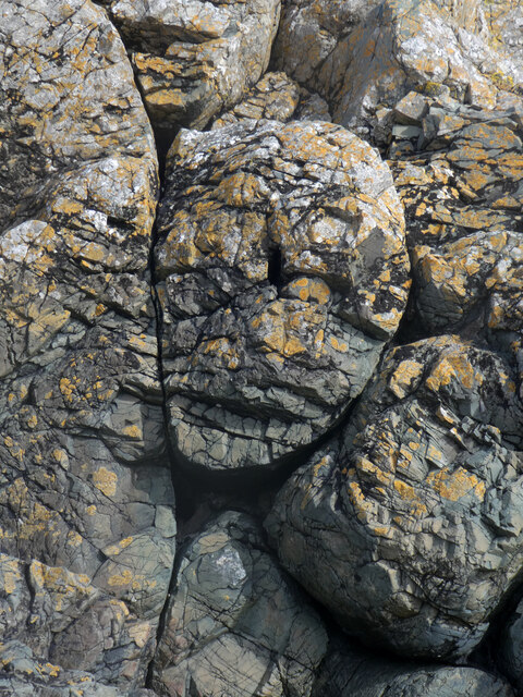
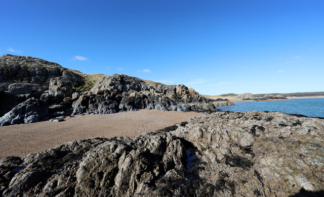
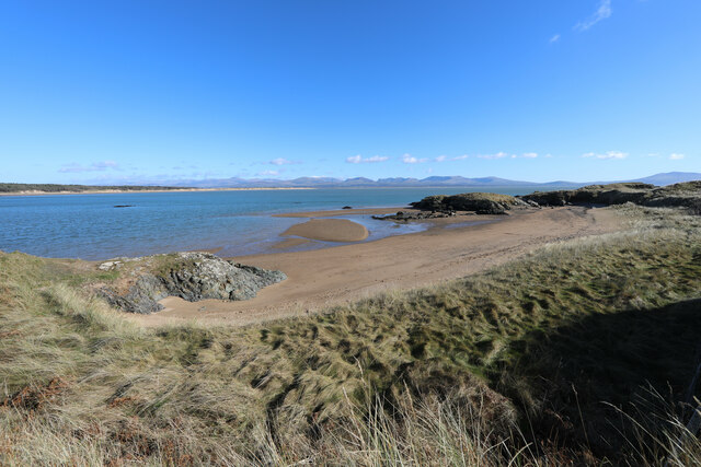
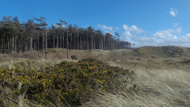
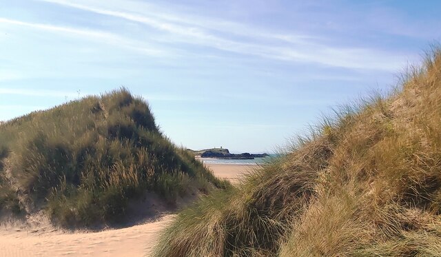
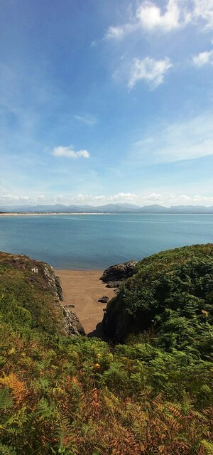
Covering an area of around 0.25 square miles, Llanddwyn Island boasts stunning natural beauty and is a popular tourist destination. It is accessible on foot during low tide, but caution should be exercised as the island can become cut off during high tide. The island features sandy beaches, rocky outcrops, and a mixture of grassland and dunes.

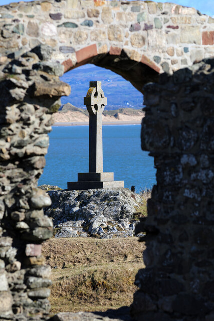
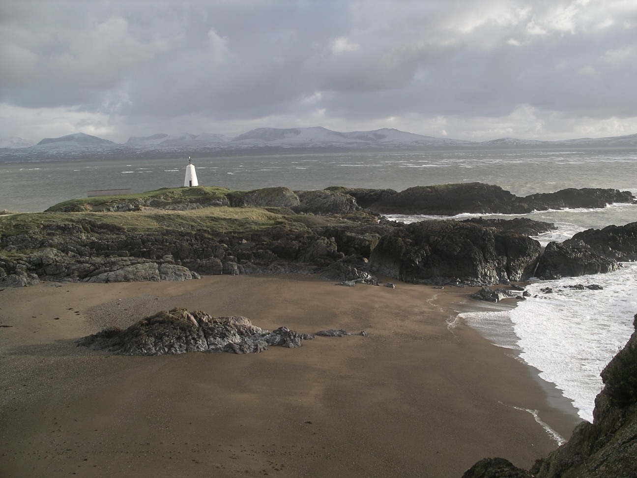
One of the main attractions on Llanddwyn Island is the picturesque Llanddwyn Beach, which stretches for approximately two miles along the island's southern coast. This beach offers breathtaking views of Snowdonia National Park and the Llŷn Peninsula. Additionally, there is a historic lighthouse located on the island, known as Twr Mawr, which has guided ships through the treacherous waters of the Menai Strait since the mid-19th century.

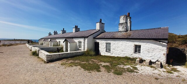
Llanddwyn Island is also home to a ruined church, dedicated to Saint Dwynwen. Pilgrims often visit the church, which is said to be the site of Dwynwen's 5th-century hermitage. The island's rich history and natural beauty make it a popular location for walks, picnics, and birdwatching.

Due to its cultural and environmental significance, Llanddwyn Island has been designated as a National Nature Reserve and a Site of Special Scientific Interest. Visitors can immerse themselves in the tranquility and serenity of this idyllic island, exploring its diverse flora and fauna while enjoying the stunning coastal scenery.

If you have any feedback on the listing, please let us know in the comments section below.

Llanddwyn Island Images

Images are sourced within 2km of 53.138714/-4.4106978 or Grid Reference SH3862. Thanks to Geograph Open Source API. All images are credited.

Edge of Newborough Forest, Llanddwyn Bay Sands
Edmygu'r nodweddion lafa clustog / Admiring the pillow lava formation
Gwyneb yn y graig / Portrait in the pillow lava
Coedwig Niwbwrch / Newborough Forest (2)
Tidal skerry off Ynys Llanddwyn This rock is a skerry at high tide, but since it is now near low water, it is easily accessible over the small tombolo beach (after a short scramble down from the busy path).
Tidal skerry off Ynys Llanddwyn
This rock is a skerry at high tide, but since it is now near low water, it is easily accessible over the small tombolo beach (after a short scramble down from the busy path).
Landing beach at Ynys Llanddwyn For sea kayakers who have paddled out of Menai Strait over Caernarfon Bar (which can be quite rough if the wind opposes the tide) this is one of the first landing places to catch breath and warm up - I remember being very glad of it on one of my early paddles (out from Plas Menai in 2002 on a circumnavigation of Anglesey). In much calmer weather today, there is an open canoe which is hiding behind the skerry in the centre of the view - not a boat to be here with in a lot of wind.
Landing beach at Ynys Llanddwyn
For sea kayakers who have paddled out of Menai Strait over Caernarfon Bar (which can be quite rough if the wind opposes the tide) this is one of the first landing places to catch breath and warm up - I remember being very glad of it on one of my early paddles (out from Plas Menai in 2002 on a circumnavigation of Anglesey). In much calmer weather today, there is an open canoe which is hiding behind the skerry in the centre of the view - not a boat to be here with in a lot of wind.
Saint Dwynwen's Cross Amongst the natural scenery of Ynys Llanddwyn, for some reason the photographer's eye is nonetheless attracted to the man-made, maybe at least partly (in geograph terms) because such objects are readily located on a map. Beyond the church and the cross, across Llanddwyn Bay lies the beach of Newborough Warren and the walk out to Abermenai Point.
Saint Dwynwen's Cross
Amongst the natural scenery of Ynys Llanddwyn, for some reason the photographer's eye is nonetheless attracted to the man-made, maybe at least partly (in geograph terms) because such objects are readily located on a map. Beyond the church and the cross, across Llanddwyn Bay lies the beach of Newborough Warren and the walk out to Abermenai Point.
Y goedwig ar lwybr y gwynt / The woodland caught by wind
Wales Coast Path in Newborough Forest
Fast drying pond in Newborough Forest Photo taken during the driest period experienced in the UK since 1976
Fast drying pond in Newborough Forest
Photo taken during the driest period experienced in the UK since 1976
Traeth Penrhos - Malltreath Bay
Through the Dunes to Llanddwyn Island
St Dwynwen's Church on Llanddwyn Island
By Llanddwyn Island at low tide
Llanddwyn Lighthouse
The path to Llanddwyn Lighthouse
Pilot's Cottages on Llanddwyn Island
Cove on the East side of Llanddwyn Island
Show me another place!

Llanddwyn Island is located at Grid Ref: SH3862 (Lat: 53.138714, Lng: -4.4106978)

Unitary Authority: Isle of Anglesey

Police Authority: North Wales

Also known as: Ynys Llanddwyn

What 3 Words

///icons.niece.unlisted. Near Caernarfon, Gwynedd

Related Wikis

Ynys Llanddwyn

Ynys Llanddwyn (also known as Llanddwyn Island) is a small tidal island off the west coast of Anglesey (Welsh: Ynys Môn), northwest Wales. The nearest...
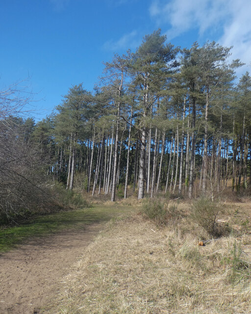
Newborough Forest

Newborough Forest (Welsh: Coedwig Niwbwrch) is a forest to the west of Newborough, Anglesey, North Wales. It is one of the most important red squirrel...

Llys Rhosyr

Llys Rhosyr, also known as "Cae Llys", is an archaeological site near Newborough in Anglesey; the ruins of a pre-Edwardian commotal court. == History... ==

Newborough Warren

Newborough Warren (Welsh: Tywyn Niwbwrch) near the village of Newborough (Niwbwrch) in Anglesey, Wales, is a large dune and beach system of 2,269 hectares...

Nearby Amenities

Located within 500m of 53.138714,-4.4106978
Source: PGS
Lat/Long: 53.1399082/-4.4112663
Source: PGS
Lat/Long: 53.1417235/-4.411708
Source: PGS
Lat/Long: 53.1412854/-4.4120523
Source: PGS
Lat/Long: 53.1403391/-4.412017
Source: PGS
Lat/Long: 53.139535/-4.4125348
Source: PGS
Lat/Long: 53.1390617/-4.4137773
Source: PGS
Lat/Long: 53.1385245/-4.4140468
Source: PGS
Lat/Long: 53.1378354/-4.4142102
Source: PGS
Lat/Long: 53.1375345/-4.4142052
Source: PGS
Lat/Long: 53.1371909/-4.4146818
Source: PGS
Lat/Long: 53.1366673/-4.4151236
Source: PGS
Lat/Long: 53.1357657/-4.4160573
Source: PGS
Lat/Long: 53.1354741/-4.4159014
Source: PGS
Lat/Long: 53.1349728/-4.4148156
Source: PGS
Lat/Long: 53.1346555/-4.4125322
Source: PGS
Lat/Long: 53.1350705/-4.4134842
Source: PGS
Lat/Long: 53.1354677/-4.4128415
Source: PGS
Lat/Long: 53.1364199/-4.4113538
Source: PGS
Lat/Long: 53.1369088/-4.4109824
Source: PGS
Lat/Long: 53.1373359/-4.4112042
Source: PGS
Lat/Long: 53.1375344/-4.4111522
Source: PGS
Lat/Long: 53.1378604/-4.4106851
Source: PGS
Lat/Long: 53.1382715/-4.409168
Source: PGS
Lat/Long: 53.1383044/-4.4083331
Source: PGS
Lat/Long: 53.1395448/-4.4074618
Source: PGS
Lat/Long: 53.139815/-4.4067571
Source: PGS
Lat/Long: 53.1400472/-4.4065376
Source: PGS
Lat/Long: 53.140501/-4.4057794
Source: PGS
Lat/Long: 53.140771/-4.4058128
Source: PGS
Lat/Long: 53.1408959/-4.4066342
Source: PGS
Lat/Long: 53.1413527/-4.4069075
Source: PGS
Lat/Long: 53.1415643/-4.4068539
Source: PGS
Lat/Long: 53.1423037/-4.4068897
Man Made: tower
Lat/Long: 53.1352499/-4.4154517
Place Of Worship
St Dwynwen's Church (ruined)
Religion: christian
Ruins: yes
Wikidata: Q7592986
Lat/Long: 53.137473/-4.4129378
St Dwynwen's Cross
Historic: monument
Lat/Long: 53.1376084/-4.4119866
Board Type: nature
Check Date: 2021-08-28
Information: board
Tourism: information
Lat/Long: 53.1423602/-4.4075979
Source: PGS
Lat/Long: 53.1424472/-4.4073502
Cross
Historic: monument
Lat/Long: 53.1369896/-4.4134422
Porth y Clochydd
Natural: bay
Lat/Long: 53.1375618/-4.4099238
Source: PGS
Lat/Long: 53.138048/-4.409938
Ffynnon y Sais
Drinking Water: no
Natural: spring
Lat/Long: 53.1408597/-4.4103096
Natural: cave_entrance
Lat/Long: 53.138619/-4.4132985
Pilot's Cove
Natural: bay
Lat/Long: 53.1350208/-4.4128269
Well
Man Made: water_well
Lat/Long: 53.1356352/-4.4128487
Porth yr Halen
Natural: bay
Lat/Long: 53.1395915/-4.4071474
Porth y Cwch
Natural: bay
Lat/Long: 53.1415553/-4.4058063
Porth yr Ogof
Natural: bay
Lat/Long: 53.1387299/-4.4146346
Ynys Llanddwyn
Ele: 10
Natural: peak
Lat/Long: 53.1370702/-4.4127611
Seamark Type: rock
Lat/Long: 53.1356276/-4.409927
Seamark Type: rock
Lat/Long: 53.1364807/-4.4098291
Seamark Type: rock
Lat/Long: 53.1378728/-4.4088669
Seamark Type: rock
Lat/Long: 53.1381205/-4.4072404
Seamark Type: rock
Lat/Long: 53.1348594/-4.4075702
Bench
Backrest: no
Lat/Long: 53.1365182/-4.4144809
Barrier: kissing_gate
Material: wood
Lat/Long: 53.1410517/-4.4071913
Historic: canon
Lat/Long: 53.1357634/-4.4131612
The data included in this document is from www.openstreetmap.org. The data is made available under ODbL.

Have you been to Llanddwyn Island?

Leave your review of Llanddwyn Island below (or comments, questions and feedback).