Boat Craig

Island in Aberdeenshire

Scotland

Boat Craig

Coast at Rattray Head High dunes fringe the sandy shore. Rattray Head Lighthouse (1895) is in the background.
<span class="nowrap"><a title="http://en.wikipedia.org/wiki/Rattray_Head" rel="nofollow ugc noopener" href="http://en.wikipedia.org/wiki/Rattray_Head">Link</a><img style="margin-left:2px;" alt="External link" title="External link - shift click to open in new window" src="https://s1.geograph.org.uk/img/external.png" width="10" height="10"/></span>
Coast at Rattray Head Credit: Colin Smith

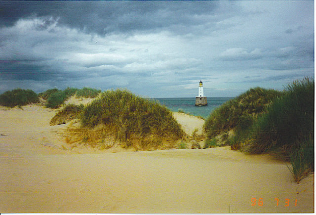
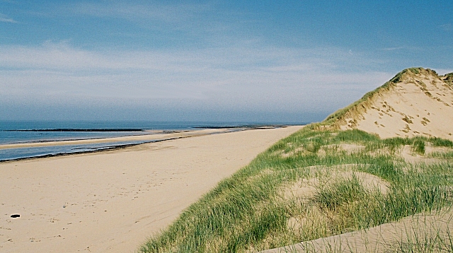
Boat Craig is a small island located off the coast of Aberdeenshire, Scotland. Situated in the North Sea, this island is part of a group of islands known as the Buchan coastline. Boat Craig is approximately 2 kilometers long and lies about 1 kilometer off the mainland.

The island is primarily composed of rugged cliffs, reaching heights of up to 30 meters, and is mostly uninhabited. It is renowned for its stunning natural beauty, with its rocky shoreline and diverse marine wildlife attracting nature enthusiasts and photographers alike.

Access to Boat Craig is limited due to its remote location and lack of infrastructure. There are no permanent structures or facilities on the island, making it a true haven for those seeking solitude in nature. However, it is possible to visit the island by boat or kayak, allowing visitors to explore its untouched landscapes and observe the abundant birdlife that inhabits the cliffs.

Boat Craig is a designated Site of Special Scientific Interest (SSSI) due to its ecological importance. The island is home to various seabird colonies, including guillemots, razorbills, and puffins. Additionally, seals and dolphins can often be spotted in the surrounding waters.

Overall, Boat Craig offers a unique and unspoiled natural experience for those willing to venture off the beaten path. Its secluded location and diverse wildlife make it a hidden gem along the Aberdeenshire coastline.

If you have any feedback on the listing, please let us know in the comments section below.

Boat Craig Images

Images are sourced within 2km of 57.615364/-1.825222 or Grid Reference NK1058. Thanks to Geograph Open Source API. All images are credited.

Coast at Rattray Head High dunes fringe the sandy shore. Rattray Head Lighthouse (1895) is in the background.
<span class="nowrap"><a title="http://en.wikipedia.org/wiki/Rattray_Head" rel="nofollow ugc noopener" href="http://en.wikipedia.org/wiki/Rattray_Head">Link</a><img style="margin-left:2px;" alt="External link" title="External link - shift click to open in new window" src="https://s1.geograph.org.uk/img/external.png" width="10" height="10"/></span>
Coast at Rattray Head
High dunes fringe the sandy shore. Rattray Head Lighthouse (1895) is in the background. LinkExternal link
Pillbox roof, Rattray, Aberdeenshire This pillbox is one of a series of 16 which overlooked an anti-tank ditch running behind the dunes for about 7km between the Loch of Strathbeg and the Black Water river to the south.  The distance between the pillboxes varied but was typically 400-600m and each pillbox usually overlooked a point where there was a change of direction in the ditch. They were all of the same design which was a Scottish variant of the Type 24.  Most of the ditch has been filled in but some lengths of it can still be traced: <a href="https://www.geograph.org.uk/photo/6996761">NK0958 : Anti-tank ditch, Rattray Head, Aberdeenshire</a>.

There is an Ordnance Survey rivet on the roof of this pillbox which can be seen near the midpoint of the lower edge of the photo.
Pillbox roof, Rattray, Aberdeenshire
This pillbox is one of a series of 16 which overlooked an anti-tank ditch running behind the dunes for about 7km between the Loch of Strathbeg and the Black Water river to the south. The distance between the pillboxes varied but was typically 400-600m and each pillbox usually overlooked a point where there was a change of direction in the ditch. They were all of the same design which was a Scottish variant of the Type 24. Most of the ditch has been filled in but some lengths of it can still be traced: NK0958 : Anti-tank ditch, Rattray Head, Aberdeenshire. There is an Ordnance Survey rivet on the roof of this pillbox which can be seen near the midpoint of the lower edge of the photo.
Former coastguard cottages, Rattray Head, Aberdeenshire The cottages have become more derelict since they were photographed by Peter eleven years ago: <a href="https://www.geograph.org.uk/photo/2310707">NK0958 : Ruins near Rattray Head</a>.
Former coastguard cottages, Rattray Head, Aberdeenshire
The cottages have become more derelict since they were photographed by Peter eleven years ago: NK0958 : Ruins near Rattray Head.
Anti-tank ditch, Rattray Head, Aberdeenshire This is one of the few remaining stretches of an anti-tank ditch which ran behind dunes for about 7km between the Loch of Strathbeg and the Black Water river to the south.  The ditch was overlooked by a series of 16 pillboxes which were mostly located at a point where the ditch changed direction.  <a href="https://www.geograph.org.uk/photo/1727248">NK0958 : Pillbox at Rattray</a> can be seen on the left and <a href="https://www.geograph.org.uk/photo/1727241">NK0958 : Pillbox at Rattray</a> is just visible on the hillside beyond it.
Anti-tank ditch, Rattray Head, Aberdeenshire
This is one of the few remaining stretches of an anti-tank ditch which ran behind dunes for about 7km between the Loch of Strathbeg and the Black Water river to the south. The ditch was overlooked by a series of 16 pillboxes which were mostly located at a point where the ditch changed direction. NK0958 : Pillbox at Rattray can be seen on the left and NK0958 : Pillbox at Rattray is just visible on the hillside beyond it.
Pillbox, Old Rattray, Aberdeenshire This is the first of a series of 16 pillboxes which overlooked an anti-tank ditch which ran for about 7km between the Loch of Strathbeg, which can be seen in the background, and the Black Water river to the south.
Pillbox, Old Rattray, Aberdeenshire
This is the first of a series of 16 pillboxes which overlooked an anti-tank ditch which ran for about 7km between the Loch of Strathbeg, which can be seen in the background, and the Black Water river to the south.
Coastal farmland near Rattray Head Arable and grazings near Rattray Head with the lighthouse and associated buildings in the distance.

This photograph was taken during the Coronavirus (COVID-19) pandemic of 2020/21/22.
Coastal farmland near Rattray Head
Arable and grazings near Rattray Head with the lighthouse and associated buildings in the distance. This photograph was taken during the Coronavirus (COVID-19) pandemic of 2020/21/22.
A beach walk at Rattray Head
Rattray Head lighthouse Erected 1895 with design innovations including foghorn and engine room incorporated into the granite base and white enamelled brickwork for the tower; automated in 1982.  B-listed (LB3042): <span class="nowrap"><a title="http://portal.historicenvironment.scot/designation/LB3042" rel="nofollow ugc noopener" href="http://portal.historicenvironment.scot/designation/LB3042">Link</a><img style="margin-left:2px;" alt="External link" title="External link - shift click to open in new window" src="https://s1.geograph.org.uk/img/external.png" width="10" height="10"/></span> .
Rattray Head lighthouse
Erected 1895 with design innovations including foghorn and engine room incorporated into the granite base and white enamelled brickwork for the tower; automated in 1982. B-listed (LB3042): LinkExternal link .
Dune landscape, Rattray Head
View northwards towards Rattray Head
The lighthouse at Rattray Head The 37 metre high lighthouse dates from 1895.

This photograph was taken during the Coronavirus (COVID-19) pandemic of 2020/21/22.
The lighthouse at Rattray Head
The 37 metre high lighthouse dates from 1895. This photograph was taken during the Coronavirus (COVID-19) pandemic of 2020/21/22.
Seatown, Rattray Head A derelict farm and associated buildings near Rattray Head.

This photograph was taken during the Coronavirus (COVID-19) pandemic of 2020/21/22.
Seatown, Rattray Head
A derelict farm and associated buildings near Rattray Head. This photograph was taken during the Coronavirus (COVID-19) pandemic of 2020/21/22.
Rattray Head Looking over the dunes towards the lighthouse
Rattray Head
Looking over the dunes towards the lighthouse
Rattery Head lighthouse
Rattray Head Lighthouse. Taken from the dunes.
Rattray Head Lighthouse.
Taken from the dunes.
Looking South over the Dunes at Rattray Head. The flarestacks at St Fergus Gas Terminal are just visible in the distance.
Looking South over the Dunes at Rattray Head.
The flarestacks at St Fergus Gas Terminal are just visible in the distance.
Dunes at Rattray Head
Rattray Lighthouse Cottages The former lighthouse shore station now offers bed and breakfast. The lighthouse is just visible beyond the dunes to the left of the house.
Rattray Lighthouse Cottages
The former lighthouse shore station now offers bed and breakfast. The lighthouse is just visible beyond the dunes to the left of the house.
Show me another place!

Boat Craig is located at Grid Ref: NK1058 (Lat: 57.615364, Lng: -1.825222)

Unitary Authority: Aberdeenshire

Police Authority: North East

What 3 Words

///sensual.bids.computers. Near Peterhead, Aberdeenshire

Related Wikis

Rattray Head

Rattray Head (), historically Rattray Point, is a headland in Buchan, Aberdeenshire, on the north-east coast Scotland. To north lies Strathbeg Bay and...

Rattray, Aberdeenshire

Rattray (historic: Rettre; occasionally: Rattery; Scottish Gaelic: Raitear), (found at grid reference NK088578) had been settled as far back as 4000 BC...

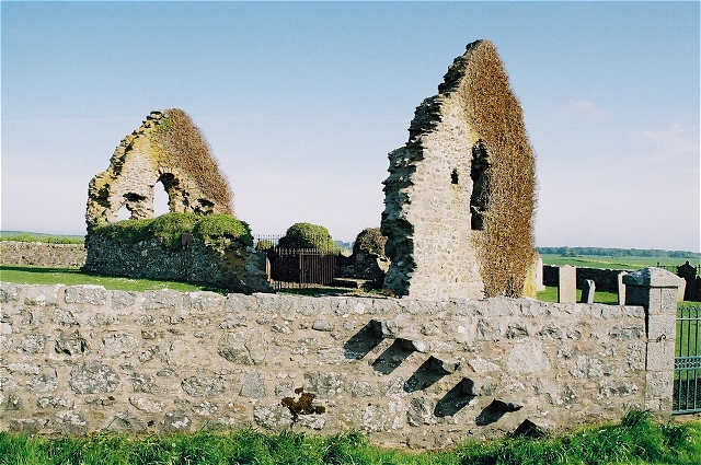
St Mary's Chapel, Rattray

St Mary's Chapel (known also as "the Chapel of the Blessed Virgin") is a late 12th/early 13th century chapel found in Rattray, Aberdeenshire, Scotland...

Castle of Rattray

The Castle of Rattray was a medieval Scottish castle, with multiple variations on its structure over approximately six centuries. Originally built as a...

Loch of Strathbeg

The Loch of Strathbeg (also known as Loch Strathbeg; historically "Strathbeg Water"; "Water of Strathbeg"; "Rattray Water" or "Water of Rattray") is a...
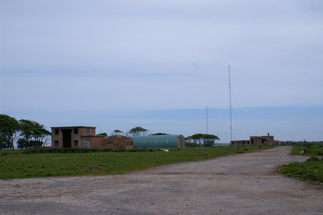
RNAS Rattray

Royal Navy Air Station Rattray, (RNAS Rattray; or HMS Merganser) and also known as Crimond Airfield, Crimond Aerodrome or Rattray Aerodrome was a Royal...

Crimond Raceway

Crimond Raceway is the most northerly stock car track in the United Kingdom. It is located about a mile from the village of Crimond in Aberdeenshire, Scotland...

Lonmay Castle

The remains of the Castle of Lonmay are found near Netherton of Lonmay, to the north of Loch Strathbeg in Buchan, Scotland. The remains are not located...

Nearby Amenities

Located within 500m of 57.615364,-1.825222
Source: Old Landsat image trace
Lat/Long: 57.6127268/-1.8239354
Source: Old Landsat image trace
Lat/Long: 57.6158151/-1.831126
Source: Old Landsat image trace
Lat/Long: 57.614042/-1.8260198
Source: Old Landsat image trace
Lat/Long: 57.6148131/-1.8272812
Source: Old Landsat image trace
Lat/Long: 57.6155076/-1.8302267
Source: Old Landsat image trace
Lat/Long: 57.6135088/-1.8254695
Source: Old Landsat image trace
Lat/Long: 57.6113203/-1.8232396
Source: Old Landsat image trace
Lat/Long: 57.6162761/-1.8327416
Source: Old Landsat image trace
Lat/Long: 57.614496/-1.8263625
Source: Old Landsat image trace
Lat/Long: 57.6150458/-1.8283791
Rattray Head
Name Sco: Rauttra Heid
Natural: cape
Place: locality
Lat/Long: 57.6114737/-1.8218428
The data included in this document is from www.openstreetmap.org. The data is made available under ODbL.

Have you been to Boat Craig?

Leave your review of Boat Craig below (or comments, questions and feedback).