Berry Snob

Island in Kincardineshire

Scotland

Berry Snob

Cliff girt coast at Muchalls
Cliff girt coast at Muchalls Credit: Alan Reid

Berry Snob is a small island located in Kincardineshire, Scotland. It is situated off the eastern coast of the country in the North Sea. The island covers an area of approximately 2 square miles and is known for its picturesque landscape and rugged coastline.

The island of Berry Snob is largely uninhabited, with only a handful of residents living here. The population is estimated to be less than 50 people, making it a peaceful and secluded destination. Visitors can access the island by boat or by a small ferry service that operates from the mainland.

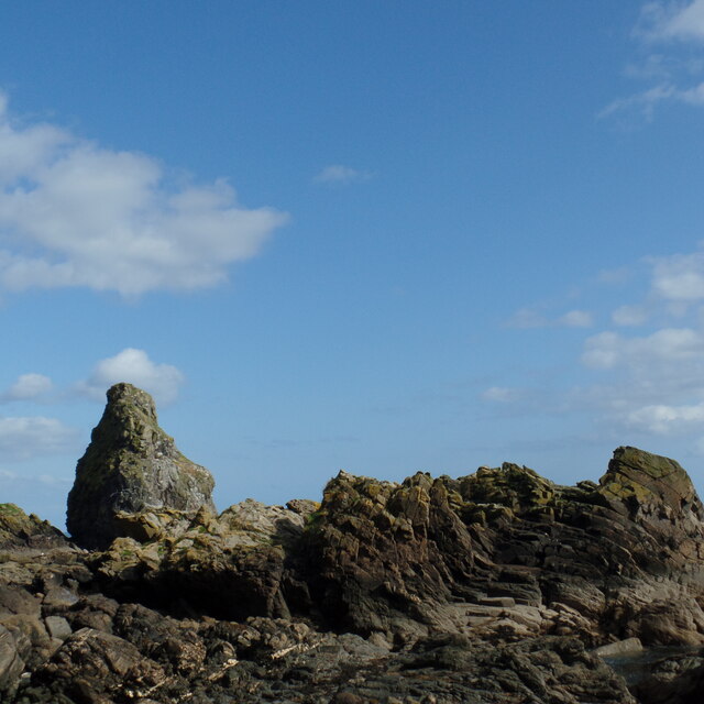
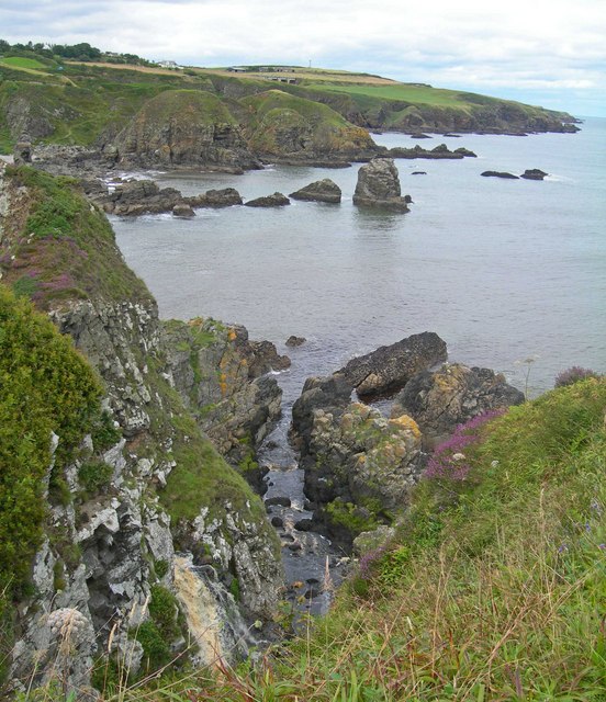
The island is characterized by its stunning natural beauty. It boasts rolling hills, green meadows, and sandy beaches, all of which provide ample opportunities for outdoor activities such as hiking, bird-watching, and beachcombing. The coastline is particularly notable, with its dramatic cliffs and breathtaking views of the sea.

Despite its small size, Berry Snob has a rich history. Ruins of an ancient castle can be found on the island, serving as a reminder of its past significance. The castle dates back to the medieval period and offers a glimpse into the island's historical importance.

While Berry Snob lacks infrastructure and amenities, it is a perfect getaway for nature lovers and those seeking tranquility. The absence of commercial development ensures an untouched and unspoiled environment. Visitors can disconnect from the hustle and bustle of the modern world and immerse themselves in the natural wonders of Berry Snob.

If you have any feedback on the listing, please let us know in the comments section below.

Berry Snob Images

Images are sourced within 2km of 56.998936/-2.1688011 or Grid Reference NO8989. Thanks to Geograph Open Source API. All images are credited.

Cliff girt coast at Muchalls
View from Doonies Point In the foreground are some of the flat-lying rocks north of a zone of intense deformation known as the Steep Belt. Compare this with <a href="https://www.geograph.org.uk/photo/6279535">NO9090 : Folded Rock</a>.
View from Doonies Point
In the foreground are some of the flat-lying rocks north of a zone of intense deformation known as the Steep Belt. Compare this with NO9090 : Folded Rock.
Cliffs at Muchalls A rather misty view north from Doonies Point, where another step, to get into the square, would have sent me hurtling down the cliff!
Cliffs at Muchalls
A rather misty view north from Doonies Point, where another step, to get into the square, would have sent me hurtling down the cliff!
Doonie Point A geo, possibly a collapsed cave, at Doonies Point. Notice that the rock strata are still lying more or less horizontal here.
Doonie Point
A geo, possibly a collapsed cave, at Doonies Point. Notice that the rock strata are still lying more or less horizontal here.
Folded Rock Compare this with <a href="https://www.geograph.org.uk/photo/6279528">NO9090 : Doonie Point</a>, just a few tens of metres away, and note that these strata have been dramatically folded so that some of them are now vertical.
Folded Rock
Compare this with NO9090 : Doonie Point, just a few tens of metres away, and note that these strata have been dramatically folded so that some of them are now vertical.
Tank Traps? These really puzzled us. On several narrow cols between the main cliffs and outlying blocks there are clusters of three concrete blocks exactly like tank traps. We couldn't image how a tank could possibly manage to get up the steep narrow paths to one of these cols, so why the need for the concrete block?
Tank Traps?
These really puzzled us. On several narrow cols between the main cliffs and outlying blocks there are clusters of three concrete blocks exactly like tank traps. We couldn't image how a tank could possibly manage to get up the steep narrow paths to one of these cols, so why the need for the concrete block?
Doonies Point A 'panoramic' view of the cliffs at Doonies Point.
Doonies Point
A 'panoramic' view of the cliffs at Doonies Point.
Douniefell with west entrance to Ship Hole This is a nearly stack/island which is part of the intertidal area below Seacliff, Muchalls. The entry to Ship Hole - shown as a subterranean passage on the 1902 version of the 25 in/mile OS - about central, but in shadow.
The top of Douniefell is a Canmore site 37225 'enclosure', undated so far.
<a href="https://www.geograph.org.uk/photo/533882">NO9091 : Coastline from Doonies Point north to Grim Brigs</a> and <a href="https://www.geograph.org.uk/photo/101421">NO9091 : Headland erosion at Muchalls</a> show it from the south. It is a bit easier to spot in the latter, in which its shadow on the cliff to the east (this camera location) makes it easier to pick out. See also the oblique aerial view from the north on Canmore.
Douniefell with west entrance to Ship Hole
This is a nearly stack/island which is part of the intertidal area below Seacliff, Muchalls. The entry to Ship Hole - shown as a subterranean passage on the 1902 version of the 25 in/mile OS - about central, but in shadow. The top of Douniefell is a Canmore site 37225 'enclosure', undated so far. NO9091 : Coastline from Doonies Point north to Grim Brigs and NO9091 : Headland erosion at Muchalls show it from the south. It is a bit easier to spot in the latter, in which its shadow on the cliff to the east (this camera location) makes it easier to pick out. See also the oblique aerial view from the north on Canmore.
Looking through Ship Hole This tunnel runs under Douniefell - see <a href="https://www.geograph.org.uk/photo/6643758">NO9091 : Douniefell with west entrance to Ship Hole</a> - and is 33m long.
According to the OS namebook, a ship was wrecked at the sea end of this, some time before it was published ca 1870.
Looking through Ship Hole
This tunnel runs under Douniefell - see NO9091 : Douniefell with west entrance to Ship Hole - and is 33m long. According to the OS namebook, a ship was wrecked at the sea end of this, some time before it was published ca 1870.
South entrance to a cave on Grum Briggs See <a href="https://www.geograph.org.uk/photo/6667229">NO9091 : North entrance to cave on Grum Briggs</a> for the north end.
As far as I know, this cannot be seen from the beach south of here because of rocky stacks - themselves not scaleable except with climbing equipment. It would be easily visible from the sea inlet behind the camera. The passage is 16m long.
South entrance to a cave on Grum Briggs
See NO9091 : North entrance to cave on Grum Briggs for the north end. As far as I know, this cannot be seen from the beach south of here because of rocky stacks - themselves not scaleable except with climbing equipment. It would be easily visible from the sea inlet behind the camera. The passage is 16m long.
A rock-scape from Grum Briggs This was taken from just inside the south end of a passage running through Grum Briggs, fairly near its eastern end. The rock face just off centre and in shadow is the north side of an un-named stack which is just north of Douniefell. There are more than 20m of sea separating Grum Briggs from this stack and you may just be able to make out a bit of sea to the left of a black boulder, and the barnacle belt above it.
A rock-scape from Grum Briggs
This was taken from just inside the south end of a passage running through Grum Briggs, fairly near its eastern end. The rock face just off centre and in shadow is the north side of an un-named stack which is just north of Douniefell. There are more than 20m of sea separating Grum Briggs from this stack and you may just be able to make out a bit of sea to the left of a black boulder, and the barnacle belt above it.
Ophelia's waterfall The burn of Muchalls flows from the Mill of Muchalls into a short gorge, then into Ophelia's pool. This is named so because it was used as a film location for a production of Hamlet. This is the overflow from Ophelia's pool. It is hard to see from anywhere else. The channel into which it flows is tidal.
Ophelia's waterfall
The burn of Muchalls flows from the Mill of Muchalls into a short gorge, then into Ophelia's pool. This is named so because it was used as a film location for a production of Hamlet. This is the overflow from Ophelia's pool. It is hard to see from anywhere else. The channel into which it flows is tidal.
Tilly Tenant Tilly Tenant is a stack, approx 30m tall.   Viewed from Hall Bay with folded rocks in the foreground.
Tilly Tenant
Tilly Tenant is a stack, approx 30m tall. Viewed from Hall Bay with folded rocks in the foreground.
Coastal cliffs near Bridge of Muchalls
The A90 passing Bridge of Muchalls from the air, at dusk
Bungalow at Hillhead of Cowie, near Bridge of Muchalls
A92 towards Bridge of Muchalls, The A92 is a major highway that runs for 89 miles through Fife, Dundee, Angus, Aberdeenshire, and Aberdeen City in Scotland. From south to north, it runs from Dunfermline to Blackdog, just north of Aberdeen.
A92 towards Bridge of Muchalls,
The A92 is a major highway that runs for 89 miles through Fife, Dundee, Angus, Aberdeenshire, and Aberdeen City in Scotland. From south to north, it runs from Dunfermline to Blackdog, just north of Aberdeen.
Cows Grazing near Bridge of Muchalls
Show me another place!

Berry Snob is located at Grid Ref: NO8989 (Lat: 56.998936, Lng: -2.1688011)

Unitary Authority: Aberdeenshire

Police Authority: North East

What 3 Words

///cooked.witty.mistress. Near Newtonhill, Aberdeenshire

Related Wikis

Limpet Burn

Limpet Burn is a watercourse in Aberdeenshire, Scotland whose discharge is deemed part of the North Sea coastal drainage. Prominent geographic features...

Doonie Point

Doonie Point is a rocky headland situated approximately 1.5 kilometres south of the village of Muchalls in Aberdeenshire, Scotland. The clifftop of Doonie...

Limpet Mill railway station

Limpet Mill was a railway station in Kincardineshire, Scotland from 1849 to 1850 on the Aberdeen Railway. == History == This station was opened on 1 November...

Mill of Muchalls

The Mill of Muchalls is an historic water-powered mill located along the Burn of Muchalls in Aberdeenshire, Scotland. This mill is situated near to the...

Nearby Amenities

Located within 500m of 56.998936,-2.1688011
Source: PGS
Lat/Long: 56.9974089/-2.1747447
Source: PGS
Lat/Long: 56.9976474/-2.1741495
Source: PGS
Lat/Long: 56.997709/-2.1736706
Source: PGS
Lat/Long: 56.9981268/-2.1729091
Source: PGS
Lat/Long: 56.9980682/-2.1724147
Source: PGS
Lat/Long: 56.998233/-2.1717452
Source: PGS
Lat/Long: 56.998153/-2.1715729
Source: PGS
Lat/Long: 56.9980894/-2.1714553
Source: PGS
Lat/Long: 56.9981121/-2.1712398
Source: PGS
Lat/Long: 56.9984766/-2.1709608
Source: PGS
Lat/Long: 56.9985364/-2.170525
Source: PGS
Lat/Long: 56.9985654/-2.1703447
Source: PGS
Lat/Long: 56.9985637/-2.170177
Source: PGS
Lat/Long: 56.998487/-2.1699978
Source: PGS
Lat/Long: 56.998613/-2.169788
Source: PGS
Lat/Long: 56.99874/-2.169551
Source: PGS
Lat/Long: 56.999251/-2.169304
Source: PGS
Lat/Long: 56.9993545/-2.1700376
Source: PGS
Lat/Long: 56.9995651/-2.1707763
Source: PGS
Lat/Long: 57.000537/-2.170214
Source: PGS
Lat/Long: 57.000658/-2.169273
Source: PGS
Lat/Long: 57.000512/-2.1684476
Source: PGS
Lat/Long: 57.001041/-2.169031
Source: PGS
Lat/Long: 57.001297/-2.169025
Source: PGS
Lat/Long: 57.0012413/-2.1684246
Source: PGS
Lat/Long: 57.00155/-2.16855
Source: PGS
Lat/Long: 57.0018215/-2.1690173
Source: PGS
Lat/Long: 57.002062/-2.168539
Source: PGS
Lat/Long: 57.002318/-2.168533
Source: PGS
Lat/Long: 57.0025992/-2.1680415
Source: PGS
Lat/Long: 57.0023886/-2.1680265
Source: PGS
Lat/Long: 57.0024762/-2.1672674
Source: PGS
Lat/Long: 57.0025393/-2.1665497
Source: PGS
Lat/Long: 57.0028253/-2.1664853
The data included in this document is from www.openstreetmap.org. The data is made available under ODbL.

Have you been to Berry Snob?

Leave your review of Berry Snob below (or comments, questions and feedback).