Spectacle
Island in Angus
Scotland
Spectacle

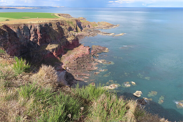
Spectacle, Angus is a small island located off the northeast coast of Scotland, in the North Sea. It is part of the Angus council area and is situated about 1.5 miles east of Arbroath. The island covers an area of approximately 8 acres and is accessible by boat.
The island gets its name from its unique shape, which resembles a pair of spectacles when viewed from above. It is composed of sandstone and is characterized by rugged cliffs and rocky shores, offering stunning views of the surrounding sea and coastline.
Spectacle, Angus is home to a variety of wildlife, including seabirds such as puffins, guillemots, and razorbills. The island is also a breeding ground for grey seals, which can often be spotted lounging on the rocks or swimming in the waters nearby.
Historically, Spectacle, Angus has been used for fishing and as a navigation aid for ships entering the nearby Arbroath Harbor. It is also rumored to have been a hiding place for smugglers in the past.
Today, the island is primarily a tourist attraction, offering visitors a chance to explore its natural beauty and observe the diverse range of wildlife. Boat trips are available for those wishing to visit the island, and guided tours provide interesting insights into its history and ecology.
In conclusion, Spectacle, Angus is a picturesque island off the coast of Scotland, known for its unique shape, stunning views, and abundant wildlife.
If you have any feedback on the listing, please let us know in the comments section below.
Spectacle Images
Images are sourced within 2km of 56.627029/-2.4813193 or Grid Reference NO7048. Thanks to Geograph Open Source API. All images are credited.


Spectacle is located at Grid Ref: NO7048 (Lat: 56.627029, Lng: -2.4813193)
Unitary Authority: Angus
Police Authority: Tayside
What 3 Words
///trips.friday.scribble. Near Arbroath, Angus
Nearby Locations
Related Wikis
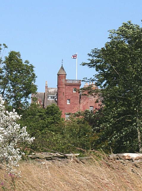
Ethie Castle
Ethie Castle is a 15,091 square feet (1,402.0 m2) 14th-century castle, situated around 3 miles north of the fishing town of Arbroath in Angus, Scotland...
Lunan Water
The Lunan Water is an easterly flowing river in Angus, Scotland, that discharges to the North Sea 11 kilometres (6.8 mi) north of the town of Arbroath...

Red Castle, Angus
Red Castle of Lunan is a ruined fortified house on the coast of Angus, Scotland. It is about 4 miles (6.4 km) south-southwest of Montrose. == History... ==

Lunan, Angus
Lunan is a hamlet in Angus, Scotland, in the parish of the same name, 6 kilometres (3.7 mi) south of Montrose. The hamlet overlooks Lunan Bay, which is...
Have you been to Spectacle?
Leave your review of Spectacle below (or comments, questions and feedback).