Beacon Rock

Island in Angus

Scotland

Beacon Rock

Street sculpture, Hawkhill, Dundee (or is it a monument/memorial?).   If anybody can supply information I will update the caption.
Street sculpture, Hawkhill, Dundee Credit: Bill Harrison

Beacon Rock is a small island located in the Angus region of Scotland. Situated off the east coast of Scotland, it is part of the North Sea and lies approximately 3 miles (4.8 kilometers) from the mainland. The island gets its name from a prominent rock formation known as Beacon Rock, which stands tall and can be seen from a distance, serving as a navigational landmark for sailors.

Beacon Rock, Angus Island, covers an area of about 0.2 square miles (0.5 square kilometers) and is mostly comprised of rocky terrain. The island is uninhabited, with no permanent residents or infrastructure. It is primarily known for its rugged beauty, offering stunning views of the surrounding sea and coastline.

The island is a popular destination for nature lovers and birdwatchers, as it is home to a variety of bird species, including puffins, guillemots, and razorbills. Visitors can observe these birds nesting and going about their daily activities, making it a haven for wildlife enthusiasts.

Access to Beacon Rock is limited, as there are no regular ferry services to the island. However, it is possible to arrange private boat trips or join guided tours that offer visits to the island, allowing visitors to explore its natural wonders and appreciate the tranquility and untouched beauty it offers.

Overall, Beacon Rock, Angus Island, is a picturesque and secluded destination, perfect for those seeking a peaceful escape amidst stunning coastal scenery and abundant wildlife.

If you have any feedback on the listing, please let us know in the comments section below.

Beacon Rock Images

Images are sourced within 2km of 56.4588/-2.9553286 or Grid Reference NO4130. Thanks to Geograph Open Source API. All images are credited.

Street sculpture, Hawkhill, Dundee (or is it a monument/memorial?).   If anybody can supply information I will update the caption.
Street sculpture, Hawkhill, Dundee
(or is it a monument/memorial?). If anybody can supply information I will update the caption.
Urban landscape, Dundee Looking towards West Port roundabout on the inner ring road (the A991) and farther back a multi-storey car park with St Mary's tower (built ca. 1495) behind.  The A-listed tower (LB25370 <span class="nowrap"><a title="http://portal.historicenvironment.scot/designation/LB25370" rel="nofollow ugc noopener" href="http://portal.historicenvironment.scot/designation/LB25370">Link</a><img style="margin-left:2px;" alt="External link" title="External link - shift click to open in new window" src="https://s1.geograph.org.uk/img/external.png" width="10" height="10"/></span> ) is the largest medieval tower in Scotland.
Urban landscape, Dundee
Looking towards West Port roundabout on the inner ring road (the A991) and farther back a multi-storey car park with St Mary's tower (built ca. 1495) behind. The A-listed tower (LB25370 LinkExternal link ) is the largest medieval tower in Scotland.
Looking down Session Street, Dundee... ...with an Indian restaurant and a nightclub in view.
Looking down Session Street, Dundee...
...with an Indian restaurant and a nightclub in view.
Urban living, Dundee style Flats, some with balconies, looking onto Hawkhill.
Urban living, Dundee style
Flats, some with balconies, looking onto Hawkhill.
Looking east on Guthrie Street, Dundee A wing of the A-listed (LB25030: <span class="nowrap"><a title="http://portal.historicenvironment.scot/designation/LB25030" rel="nofollow ugc noopener" href="http://portal.historicenvironment.scot/designation/LB25030">Link</a><img style="margin-left:2px;" alt="External link" title="External link - shift click to open in new window" src="https://s1.geograph.org.uk/img/external.png" width="10" height="10"/></span> ) Tay Works jute mill dominates the picture.
Looking east on Guthrie Street, Dundee
A wing of the A-listed (LB25030: LinkExternal link ) Tay Works jute mill dominates the picture.
Past glories at Dundee Part of the gigantic 58-bay facade of Tay Works jute mill, now converted to student flats.   The mill is A-listed (LB25030: <span class="nowrap"><a title="http://portal.historicenvironment.scot/designation/LB25030" rel="nofollow ugc noopener" href="http://portal.historicenvironment.scot/designation/LB25030">Link</a><img style="margin-left:2px;" alt="External link" title="External link - shift click to open in new window" src="https://s1.geograph.org.uk/img/external.png" width="10" height="10"/></span> ).  The inner ring road (the A991) now runs alongside.  The A991 is almost 3 km in length: <span class="nowrap"><a title="https://en.wikipedia.org/wiki/A991_road" rel="nofollow ugc noopener" href="https://en.wikipedia.org/wiki/A991_road">Link</a><img style="margin-left:2px;" alt="External link" title="External link - shift click to open in new window" src="https://s1.geograph.org.uk/img/external.png" width="10" height="10"/></span> .
Past glories at Dundee
Part of the gigantic 58-bay facade of Tay Works jute mill, now converted to student flats. The mill is A-listed (LB25030: LinkExternal link ). The inner ring road (the A991) now runs alongside. The A991 is almost 3 km in length: LinkExternal link .
1 Courthouse Square, Dundee Dating from 1927 with art deco touches.  The Canmore listing (235298: <span class="nowrap"><a title="https://canmore.org.uk/site/235298/dundee-29-ward-road-bank" rel="nofollow ugc noopener" href="https://canmore.org.uk/site/235298/dundee-29-ward-road-bank">Link</a><img style="margin-left:2px;" alt="External link" title="External link - shift click to open in new window" src="https://s1.geograph.org.uk/img/external.png" width="10" height="10"/></span> ) identifies it as a former bank, but no further details are given.  The ground floor appears to now be occupied by a tutorial agency.
1 Courthouse Square, Dundee
Dating from 1927 with art deco touches. The Canmore listing (235298: LinkExternal link ) identifies it as a former bank, but no further details are given. The ground floor appears to now be occupied by a tutorial agency.
Dundee Sheriff Court The B-listed (LB25631 <span class="nowrap"><a title="http://portal.historicenvironment.scot/designation/LB25631" rel="nofollow ugc noopener" href="http://portal.historicenvironment.scot/designation/LB25631">Link</a><img style="margin-left:2px;" alt="External link" title="External link - shift click to open in new window" src="https://s1.geograph.org.uk/img/external.png" width="10" height="10"/></span> ) Classical structure dates from 1863 with later additions.  Note the Scottish version of the royal arms in the tympanum.
Dundee Sheriff Court
The B-listed (LB25631 LinkExternal link ) Classical structure dates from 1863 with later additions. Note the Scottish version of the royal arms in the tympanum.
Dundee police war memorial Memorial to those who fell in WW1 (16) and WW2 (8).  C-listed (LB25633 <span class="nowrap"><a title="http://portal.historicenvironment.scot/designation/LB25633" rel="nofollow ugc noopener" href="http://portal.historicenvironment.scot/designation/LB25633">Link</a><img style="margin-left:2px;" alt="External link" title="External link - shift click to open in new window" src="https://s1.geograph.org.uk/img/external.png" width="10" height="10"/></span> ).
Dundee police war memorial
Memorial to those who fell in WW1 (16) and WW2 (8). C-listed (LB25633 LinkExternal link ).
Dundee police headquarters, Marketgait
Dundee ring road scene Marketgait (the A991) with a chimney possibly associated with Tay Works jute mill to the left and the police headquarters to the right.  Farther back behind the roundabout is part of Abertay University, possibly student accommodation.
Dundee ring road scene
Marketgait (the A991) with a chimney possibly associated with Tay Works jute mill to the left and the police headquarters to the right. Farther back behind the roundabout is part of Abertay University, possibly student accommodation.
Looking towards Dudhope roundabout, Dundee A green-liveried hydrogen-powered bus is visible.
Looking towards Dudhope roundabout, Dundee
A green-liveried hydrogen-powered bus is visible.
Elim Pentecostal Church, Dundee In the right background is St Mary Magdalene's Scottish Episcopal Church.  Note the nepus gables in the tenements in the background.
Elim Pentecostal Church, Dundee
In the right background is St Mary Magdalene's Scottish Episcopal Church. Note the nepus gables in the tenements in the background.
St Mary Magdalene's Scottish Episcopal Church, Dundee Built ca. 1867 for the Catholic Apostolic Church (<span class="nowrap"><a title="https://en.wikipedia.org/wiki/Catholic_Apostolic_Church" rel="nofollow ugc noopener" href="https://en.wikipedia.org/wiki/Catholic_Apostolic_Church">Link</a><img style="margin-left:2px;" alt="External link" title="External link - shift click to open in new window" src="https://s1.geograph.org.uk/img/external.png" width="10" height="10"/></span> ) but the Dundee congregation disbanded in 1945 and the Episcopalians took over the building in 1952: B-listed (LB25113: <span class="nowrap"><a title="http://portal.historicenvironment.scot/designation/LB25113" rel="nofollow ugc noopener" href="http://portal.historicenvironment.scot/designation/LB25113">Link</a><img style="margin-left:2px;" alt="External link" title="External link - shift click to open in new window" src="https://s1.geograph.org.uk/img/external.png" width="10" height="10"/></span> ). The inner ring road passes in front.
St Mary Magdalene's Scottish Episcopal Church, Dundee
Built ca. 1867 for the Catholic Apostolic Church (LinkExternal link ) but the Dundee congregation disbanded in 1945 and the Episcopalians took over the building in 1952: B-listed (LB25113: LinkExternal link ). The inner ring road passes in front.
Electric bike hire and charging station, Dundee
Constitution Road, Dundee Just north of the inner ring road, tenements with impressive chimneys...
Constitution Road, Dundee
Just north of the inner ring road, tenements with impressive chimneys...
Looking up Constitution Road, Dundee The road is presumably one-way because of its steepness.  The 'except for access' Laurel Bank curves away to the right and re-joins Constitution Road farther up the hill, having made a P-shape, with a number of fine Victorian villas along its length.
Looking up Constitution Road, Dundee
The road is presumably one-way because of its steepness. The 'except for access' Laurel Bank curves away to the right and re-joins Constitution Road farther up the hill, having made a P-shape, with a number of fine Victorian villas along its length.
Glimpse of a villa A fine Classical villa dating from ca. 1837 at the corner of Constitution Road and Union Terrace, which was once occupied by a jute magnate.   B-listed: LB25506 <span class="nowrap"><a title="http://portal.historicenvironment.scot/designation/LB25506" rel="nofollow ugc noopener" href="http://portal.historicenvironment.scot/designation/LB25506">Link</a><img style="margin-left:2px;" alt="External link" title="External link - shift click to open in new window" src="https://s1.geograph.org.uk/img/external.png" width="10" height="10"/></span> .
Glimpse of a villa
A fine Classical villa dating from ca. 1837 at the corner of Constitution Road and Union Terrace, which was once occupied by a jute magnate. B-listed: LB25506 LinkExternal link .
Show me another place!

Beacon Rock is located at Grid Ref: NO4130 (Lat: 56.4588, Lng: -2.9553286)

Unitary Authority: City of Dundee

Police Authority: Tayside

What 3 Words

///beast.laying.league. Near Dundee, Dundee City

Nearby Locations

Fowler Rock Beacon Rock

Related Wikis

North Carr Lightship

North Carr is the last remaining Scottish lightship. She is 101 feet (31 m) in length, 25 feet (7.6 m) in beam and 268 tons. The purpose of the vessel...

HMS Unicorn (1824)

HMS Unicorn is a surviving sailing frigate of the successful Leda class, although the original design had been modified by the time that the Unicorn was...

Dundee International Submarine Memorial

Dundee International Submarine Memorial commemorates the 296 sailors and commandos lost on operations from the submarine base at Dundee in Scotland, HMS...

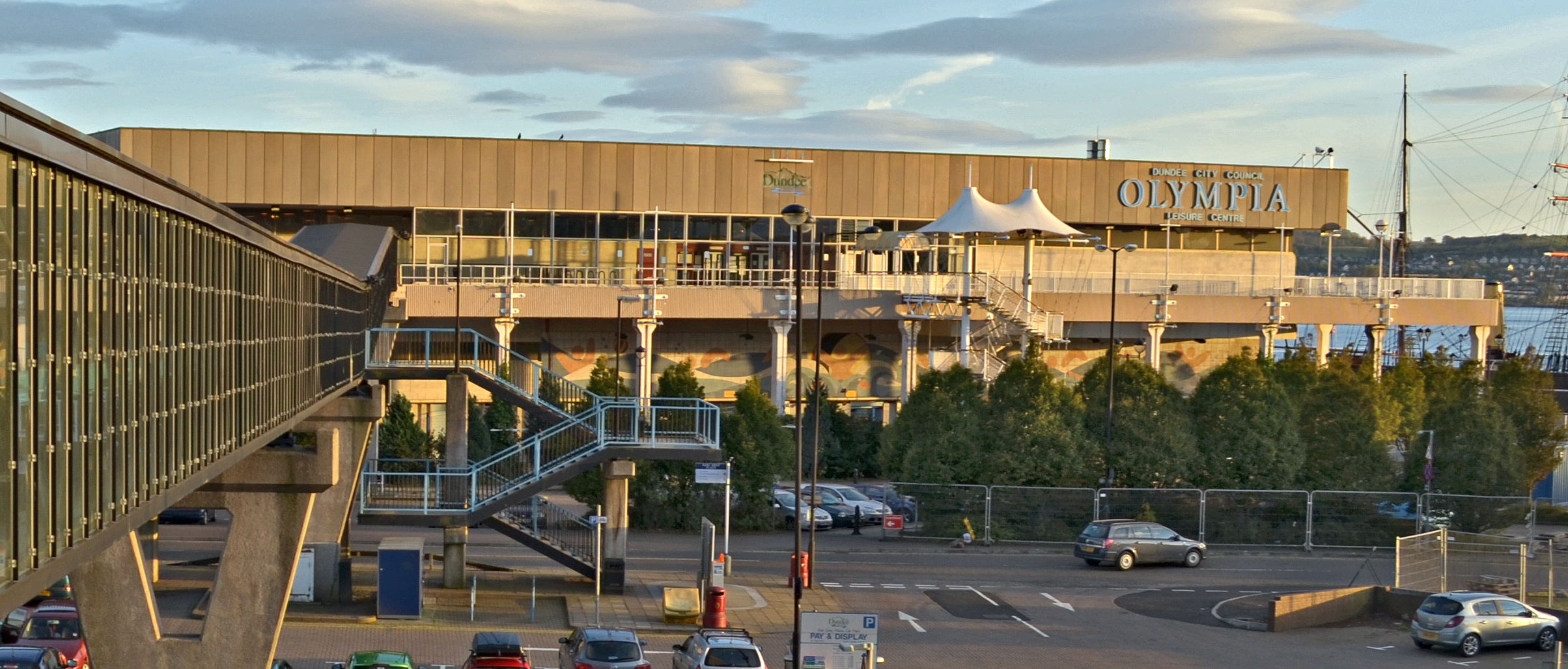
Olympia Leisure Centre (1974)

The Olympia Leisure Centre was a swimming pool in Dundee. == History == The facility was built on an infilled dock.The facility opened on 15 July 1974...

RRS Discovery

The RRS Discovery is a barque-rigged auxiliary steamship built in Dundee, Scotland for Antarctic research. Launched in 1901, she was the last traditional...

V&A Dundee

V&A Dundee is a design museum in Dundee, Scotland, which opened on 15 September 2018. The V&A Dundee is the first design museum in Scotland and the first...

Olympia Leisure Centre (2013)

The Olympia Leisure Centre is a swimming pool in Dundee, Scotland. It is currently closed for repair work. == History == The building was constructed to...

Seagate bus station

Seagate bus station serves Dundee, Scotland. It has eight stances. The Seagate Bus Station is the main stop for journeys leaving the city, while in-town...

Nearby Amenities

Located within 500m of 56.4588,-2.9553286
Created By: almien_coastlines
Lat/Long: 56.4628912/-2.9529268
Created By: almien_coastlines
Lat/Long: 56.462711/-2.9523088
Created By: almien_coastlines
Lat/Long: 56.4622747/-2.9511587
Bicycle: yes
Foot: yes
Man Made: lift
Lat/Long: 56.4591312/-2.9630427
Tourism: viewpoint
Lat/Long: 56.4595359/-2.960994
Barrier: bollard
Bicycle: yes
Bollard: removable
Foot: yes
Lat/Long: 56.4611757/-2.9552626
Barrier: bollard
Bicycle: yes
Bollard: removable
Foot: yes
Lat/Long: 56.4614918/-2.9542275
Barrier: bollard
Bicycle: yes
Bollard: removable
Foot: yes
Motorcycle: yes
Lat/Long: 56.4605802/-2.9609176
Cafe
Café Cressy
Addr City: Dundee
Addr Postcode: DD1 3JA
Addr Street: Camperdown Street
Addr Suburb: City Quay
Fhrs Id: 186065
Source Addr: FHRS Open Data
Lat/Long: 56.4620028/-2.960185
Dentist
City Quay Dental Clinic
Healthcare: dentist
Lat/Long: 56.4622823/-2.9594241
City Quay
Is In: Dundee, Scotland
Place: suburb
Source: knowledge
Lat/Long: 56.4608227/-2.9584866
Dundee International Submarine Memorial
Addr City: Dundee
Addr Street: Camperdown Street
Description: 'Still on Patrol' a sculpture by artists Jeremy Cunningham and Paul Grime.
Historic: memorial
Inscription: Names of submariners lost with their submarines from the International Brigade during the WW2
Memorial: war_memorial
Wikidata: Q5314825
Wikipedia: en:Dundee International Submarine Memorial
Lat/Long: 56.4628189/-2.9563015
Recycling
Recycling Glass: yes
Recycling Type: container
Lat/Long: 56.4613784/-2.95839
Crossing
Crossing: traffic_signals
Lat/Long: 56.4600755/-2.9629196
Barrier: lift_gate
Bicycle: yes
Foot: yes
Lat/Long: 56.4598578/-2.9629183
Seamark Name: Beacon Rock
Seamark Radar Reflector: yes
Seamark Type: beacon_isolated_danger
Source: bing
Lat/Long: 56.4587727/-2.9555512
Seamark Name: Fowler Rock
Seamark Type: beacon_isolated_danger
Source: bing
Lat/Long: 56.4595724/-2.9558736
Seamark Buoy Lateral Category: port
Seamark Buoy Lateral Colour: red
Seamark Buoy Lateral Shape: can
Seamark Buoy Lateral System: iala-a
Seamark Type: buoy_lateral
Source: bing
Lat/Long: 56.4600071/-2.9543444
Telford Beacon
Historic: monument
Lat/Long: 56.4589516/-2.9630685
Bicycle Parking
Bicycle Parking: stands
Capacity: 8
Covered: yes
Lat/Long: 56.4595993/-2.9611752
Bicycle Parking
Bicycle Parking: stands
Capacity: 8
Covered: yes
Lat/Long: 56.4598071/-2.9613923
Bicycle Parking
Bicycle Parking: stands
Capacity: 24
Covered: yes
Lat/Long: 56.4600289/-2.9616305
Bicycle Parking
Bicycle Parking: stands
Capacity: 24
Covered: yes
Lat/Long: 56.4601991/-2.9618085
Good health & fitness
Leisure: fitness_centre
Lat/Long: 56.4620248/-2.9609891
Tina O'Doherty's
Level: 0
Shop: beauty
Lat/Long: 56.4621132/-2.9601874
Panmure Passage
Addr City: Dundee
Addr Housenumber: 0
Addr Street: Marine Parade Walk
Artist Name: Marion Smith
Artwork Type: sculpture
Description: Sculpture, showing the sections of the RS Discovery. Located on the site of the slip that Discovery was built on.
Tourism: artwork
Lat/Long: 56.4600403/-2.95982
Wakeboarding track
Addr City: Dundee
Addr Country: GB
Addr Postcode: DD1 3JP
Addr Street: West Victoria Dock Road
Leisure: water_park
Operator: Foxlake Dundee
Website: https://www.foxlakedundee.co.uk/info/gettinghere/
Lat/Long: 56.4609788/-2.9624149
Railway: switch
Lat/Long: 56.4606912/-2.9622289
Railway: switch
Lat/Long: 56.4608434/-2.9624051
Railway: railway_crossing
Lat/Long: 56.4624579/-2.9508367
Parking
Access: private
Parking: surface
Lat/Long: 56.4599071/-2.9608617
Parking
Access: private
Parking: surface
Lat/Long: 56.4602076/-2.9611648
Post Box
Brand: Royal Mail
Brand Wikidata: Q638098
Collection Times: Mo-Fr 15:45; Sa 11:00
Manufacturer: ROMEC
Operator: Royal Mail
Operator Wikidata: Q638098
Post Box Design: 2010_pattern
Post Box Type: pillar
Ref: DD1 999
Royal Cypher: scottish_crown
Source: survey
Lat/Long: 56.4605407/-2.9623263
Dentist
Waterside Dental Care
Addr City: Dundee
Addr Housenumber: Unit 33, Shed 26
Addr Postcode: DD1 3JA
Addr Street: Camperdown Street
Healthcare: dentist
Healthcare Speciality: dental_oral_maxillo_facial_surgery
Opening Hours: Mo-Th 08:30-17:30; Fr 08:30-17:00
Operator: Cooper Russell & Associates
Phone: +441382322347
Website: https://www.watersidedentaldundee.co.uk/
Lat/Long: 56.4628606/-2.9586703
Addr Housenumber: 17
Lat/Long: 56.4609304/-2.9575823
The data included in this document is from www.openstreetmap.org. The data is made available under ODbL.

Have you been to Beacon Rock?

Leave your review of Beacon Rock below (or comments, questions and feedback).