Aig a' Chreathair

Island in Sutherland

Scotland

Aig a' Chreathair

View over Strath Melness, Sutherland Strath Melness is a small valley on the north coast of Scotland.  The peaks of Ben Loyal are in the background.
View over Strath Melness, Sutherland Credit: Andrew Tryon

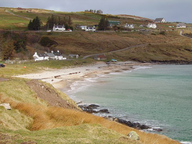
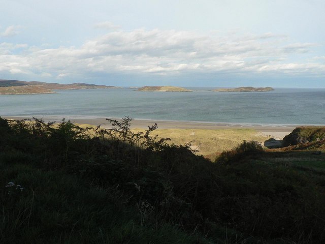
Aig a' Chreathair is a small island located in Sutherland, Scotland. It is situated in the far northwestern part of the country, off the northwest coast of Scotland. The island is part of the larger Summer Isles archipelago, which consists of several other islands.

With an area of approximately 160 hectares, Aig a' Chreathair is relatively small in size. It is characterized by its rugged and rocky terrain, typical of the Scottish Highlands. The island is surrounded by the clear waters of the North Atlantic Ocean, providing breathtaking views and a tranquil atmosphere.

The vegetation on Aig a' Chreathair is diverse, with a mix of heather, grasses, and scattered trees. The island is home to various bird species, including seabirds such as puffins and guillemots, making it a haven for birdwatchers and nature enthusiasts.

Access to the island is mainly by boat, as there are no permanent settlements or facilities on Aig a' Chreathair. Visitors can explore the island's shoreline, take in the stunning natural landscapes, and enjoy the peacefulness that comes with being surrounded by the ocean.

Due to its remote location, Aig a' Chreathair offers a unique sense of isolation and tranquility. It is a place where visitors can disconnect from the hustle and bustle of modern life and immerse themselves in the beauty of nature. Whether it's exploring the rocky coastline, observing wildlife, or simply enjoying the serenity of the surroundings, Aig a' Chreathair offers a truly unforgettable experience for those who venture to this remote island.

If you have any feedback on the listing, please let us know in the comments section below.

Aig a' Chreathair Images

Images are sourced within 2km of 58.554381/-4.434332 or Grid Reference NC5865. Thanks to Geograph Open Source API. All images are credited.

View over Strath Melness, Sutherland Strath Melness is a small valley on the north coast of Scotland.  The peaks of Ben Loyal are in the background.
View over Strath Melness, Sutherland
Strath Melness is a small valley on the north coast of Scotland. The peaks of Ben Loyal are in the background.
Disused Postbox at Dalnafree, Strath Melness, Sutherland An old postbox painted black and covered with a metal plate to prevent usage.
Disused Postbox at Dalnafree, Strath Melness, Sutherland
An old postbox painted black and covered with a metal plate to prevent usage.
Wintry road in Melness A collection of photographs (just one from each contributor) taken on New Year's Day 2023 by Geographers from all over Great Britain, Ireland and the Isle of Man.

View all the photos on a map here: <a title="https://www.geograph.org.uk/search.php?i=172163615" href="https://www.geograph.org.uk/search.php?i=172163615">Link</a>
Wintry road in Melness
A collection of photographs (just one from each contributor) taken on New Year's Day 2023 by Geographers from all over Great Britain, Ireland and the Isle of Man. View all the photos on a map here: Link
Divergence The track splits here. I took the left one.
Divergence
The track splits here. I took the left one.
Loch Vasgo
Loch Vasgo
All calm at Port Vasgo This fantastic natural harbour is laborious to reach but well worth it when the weather holds out. This photo looks NNE from the bottom of the grid square.
All calm at Port Vasgo
This fantastic natural harbour is laborious to reach but well worth it when the weather holds out. This photo looks NNE from the bottom of the grid square.
View of Talmine Taken from the right hand side of the square looking directly South over the bay.
View of Talmine
Taken from the right hand side of the square looking directly South over the bay.
From the harbour at Talmine When the tide is out, this is a great beach, sandy and with ship wrecks in the sand.
From the harbour at Talmine
When the tide is out, this is a great beach, sandy and with ship wrecks in the sand.
Croft land, Achnahuaigh The drainage is failing but there is some improved land near the almost ruined house, now used as a byre.
Croft land, Achnahuaigh
The drainage is failing but there is some improved land near the almost ruined house, now used as a byre.
Loch Vasgo In the midst of some very rugged terrain. Thin peaty soils unfit for cultivation.
Loch Vasgo
In the midst of some very rugged terrain. Thin peaty soils unfit for cultivation.
Farmyard in Strath Melness Shorthorn cow and calf. The calf is very young and has not yet had its EU eartag fitted. (All cattle carry "numberplates in the European Union.") The cow was unhappy , but there was an easy route round.
Farmyard in Strath Melness
Shorthorn cow and calf. The calf is very young and has not yet had its EU eartag fitted. (All cattle carry "numberplates in the European Union.") The cow was unhappy , but there was an easy route round.
Achnahuaigh Sheep and ruin on croftland at the mouth of the Kyle of Tongue.
Achnahuaigh
Sheep and ruin on croftland at the mouth of the Kyle of Tongue.
Allt na Caillich Waterfalls where the burn runs steeply down off Ben Hutig to Strath Melness
Allt na Caillich
Waterfalls where the burn runs steeply down off Ben Hutig to Strath Melness
Ruin, Strath Melness Once a glen like Strath Melness would have had a larger population. The usual story , repeated throughout Britain is that new generations leave for education and to seek work. Those that remain have often moved to newer more comfortable houses, leaving many ruins behind. Other redundant houses are used as farm buildings.
Ruin, Strath Melness
Once a glen like Strath Melness would have had a larger population. The usual story , repeated throughout Britain is that new generations leave for education and to seek work. Those that remain have often moved to newer more comfortable houses, leaving many ruins behind. Other redundant houses are used as farm buildings.
Achininver Beach
Achininver Beach
Strath Melness Looking up Strath Melness from the beach at Achininver
Strath Melness
Looking up Strath Melness from the beach at Achininver
Acininver Beach Small north facing sandy bay at Acininver
Acininver Beach
Small north facing sandy bay at Acininver
Midfield Beach A fantastic place!
Midfield Beach
A fantastic place!
Show me another place!

Aig a' Chreathair is located at Grid Ref: NC5865 (Lat: 58.554381, Lng: -4.434332)

Unitary Authority: Highland

Police Authority: Highlands and Islands

What 3 Words

///inflamed.sulked.become. Near Altnaharra, Highland

Related Wikis

Midfield, Highland

Midfield is a remote hamlet on the north coast of Scotland in Sutherland in the Highland Council Area. It is a mile south of Tormade Point and just over...

Achnahuaigh

Achnahuaigh or Achinahuaigh (Scottish Gaelic: Achadh na h-Uamha) is a crofting hamlet and neighbourhood in the Melness area of Sutherland in the Highland...

Melness

Melness (Gaelic: Taobh Mhealanais) is a locality, comprising a group of small remote crofting townships, lying to the west of Tongue Bay opposite Coldbackie...

Talmine, Sutherland

Talmine is a crofting and fishing township, overlooking Talmine Bay, an inlet on the western shore of Tongue Bay in northern Sutherland, Scottish Highlands...

Tongue Bay

Tongue Bay (Scottish Gaelic: Tunga from Old Norse: Tunga) is located in northwest Highland, Scotland, in the western part of the former county of Sutherland...

Eilean nan Ròn

Eilean nan Ròn (Scottish Gaelic: island of the seals) is an island near Skerray, in the north of Sutherland, Scotland. An estimated 350 seal pups are born...

Skullomie

Scullomie is a small fishing and crofting township at the head of Tongue Bay in Sutherland in the Scottish Highlands. It is located around 3 miles (4...

Coldbackie

Coldbackie (Scottish Gaelic: Callbacaidh) is a crofting township in Sutherland and is in the Scottish council area of Highland Scotland. == Geography... ==

Nearby Amenities

Located within 500m of 58.554381,-4.434332
Source: PGS
Lat/Long: 58.55042/-4.4339591
Source: PGS
Lat/Long: 58.5506101/-4.4329039
Source: PGS
Lat/Long: 58.5507483/-4.433069
Source: PGS
Lat/Long: 58.5512123/-4.433471
Source: PGS
Lat/Long: 58.5513093/-4.4337344
Source: PGS
Lat/Long: 58.5515307/-4.4335091
Source: PGS
Lat/Long: 58.5516995/-4.4331443
Source: PGS
Lat/Long: 58.5520488/-4.4323719
Source: PGS
Lat/Long: 58.5521414/-4.4315779
Source: PGS
Lat/Long: 58.5525705/-4.4319963
Source: PGS
Lat/Long: 58.5530717/-4.4325022
Source: PGS
Lat/Long: 58.5533742/-4.4320071
Source: PGS
Lat/Long: 58.5535908/-4.4320393
Source: PGS
Lat/Long: 58.55419/-4.433246
Source: PGS
Lat/Long: 58.5541839/-4.4338524
Source: PGS
Lat/Long: 58.5542466/-4.4342387
Source: PGS
Lat/Long: 58.5542474/-4.4344103
Source: PGS
Lat/Long: 58.554286/-4.4345498
Source: PGS
Lat/Long: 58.5542799/-4.4347641
Source: PGS
Lat/Long: 58.5542482/-4.435236
Source: PGS
Lat/Long: 58.5540472/-4.4365724
Source: PGS
Lat/Long: 58.5542464/-4.4368366
Source: PGS
Lat/Long: 58.554444/-4.4366614
Source: PGS
Lat/Long: 58.5548894/-4.4363844
Source: PGS
Lat/Long: 58.5553895/-4.4360518
Source: PGS
Lat/Long: 58.555461/-4.4367681
Source: PGS
Lat/Long: 58.5556844/-4.4366805
Source: PGS
Lat/Long: 58.5557718/-4.436825
Source: PGS
Lat/Long: 58.5558635/-4.4369638
Source: PGS
Lat/Long: 58.5559648/-4.4372749
Source: PGS
Lat/Long: 58.5562827/-4.4370282
Source: PGS
Lat/Long: 58.5560115/-4.438054
Source: PGS
Lat/Long: 58.5563016/-4.4379581
Source: PGS
Lat/Long: 58.5563349/-4.4387455
Source: PGS
Lat/Long: 58.5556441/-4.4396245
Source: PGS
Lat/Long: 58.5554452/-4.4398928
Source: PGS
Lat/Long: 58.5552722/-4.4400644
Source: PGS
Lat/Long: 58.5548824/-4.440529
Source: PGS
Lat/Long: 58.5545776/-4.4399679
Source: PGS
Lat/Long: 58.5539681/-4.4404614
Source: PGS
Lat/Long: 58.5537604/-4.4412843
Source: PGS
Lat/Long: 58.5532007/-4.4413556
Source: PGS
Lat/Long: 58.5531403/-4.4413792
Source: PGS
Lat/Long: 58.5516976/-4.4278026
Source: PGS
Lat/Long: 58.5515806/-4.4281257
Source: PGS
Lat/Long: 58.5511723/-4.4288072
Source: PGS
Lat/Long: 58.5510895/-4.429683
Source: PGS
Lat/Long: 58.5509196/-4.4306698
Source: PGS
Lat/Long: 58.5509398/-4.4310711
Source: PGS
Lat/Long: 58.550677/-4.4313586
Source: PGS
Lat/Long: 58.5505035/-4.4318371
Source: PGS
Lat/Long: 58.5504736/-4.4325136
Source: PGS
Lat/Long: 58.5505437/-4.432789
The data included in this document is from www.openstreetmap.org. The data is made available under ODbL.

Have you been to Aig a' Chreathair?

Leave your review of Aig a' Chreathair below (or comments, questions and feedback).