Luton

Settlement in Kent

England

Luton

Capstone Farm Country Park, near Gillingham Black headed gulls sitting on the footbridge over the lake.  Capstone Farm Country Park covers 114 hectares of former farmland set on the North Downs. There is a variety of habitats within the park, including ancient woodlands, old orchards, a freshwater lake, meadows and hedgerows.
Capstone Farm Country Park, near Gillingham Credit: pam fray

Luton is a small village located in the county of Kent, England. Situated in the southeastern part of the country, it is nestled in the picturesque landscape of the Kent Downs, an Area of Outstanding Natural Beauty. Luton is approximately 5 miles south of Maidstone, the county town of Kent.

The village is known for its charming and tranquil atmosphere, offering a peaceful retreat from the hustle and bustle of nearby towns. Luton's rural setting provides a delightful backdrop for outdoor enthusiasts and nature lovers, with ample opportunities for hiking, cycling, and exploring the surrounding countryside.

Luton boasts a small but close-knit community, with friendly locals who take pride in their village. The village center features a quaint parish church, St. Nicholas, which dates back to the 12th century and is a notable architectural landmark in the area. Additionally, there is a village hall that serves as a hub for community activities and events.

Despite its small size, Luton offers some amenities to its residents. These include a local primary school, a post office, and a few shops and convenience stores. However, for a wider range of amenities and services, residents can easily access nearby towns such as Maidstone or the town of Bearsted, which is just a short drive away.

Overall, Luton is a picturesque village that offers a peaceful and idyllic lifestyle, making it an attractive place to live for those seeking a quiet and rural retreat in the beautiful county of Kent.

If you have any feedback on the listing, please let us know in the comments section below.
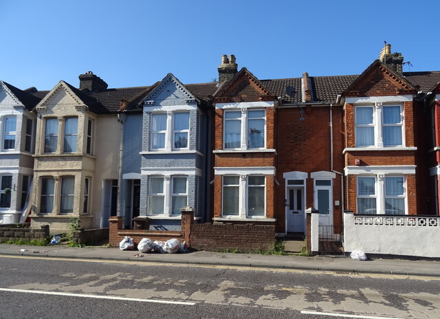
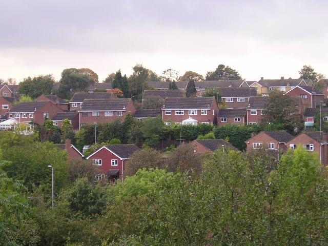
Luton Images

Images are sourced within 2km of 51.369131/0.540295 or Grid Reference TQ7666. Thanks to Geograph Open Source API. All images are credited.

Capstone Farm Country Park, near Gillingham Black headed gulls sitting on the footbridge over the lake.  Capstone Farm Country Park covers 114 hectares of former farmland set on the North Downs. There is a variety of habitats within the park, including ancient woodlands, old orchards, a freshwater lake, meadows and hedgerows.
Capstone Farm Country Park, near Gillingham
Black headed gulls sitting on the footbridge over the lake. Capstone Farm Country Park covers 114 hectares of former farmland set on the North Downs. There is a variety of habitats within the park, including ancient woodlands, old orchards, a freshwater lake, meadows and hedgerows.
Capstone Farm Country Park, near Gillingham Footpath to the east of the lake.  Capstone Farm Country Park covers 114 hectares of former farmland set on the North Downs. There is a variety of habitats within the park, including ancient woodlands, old orchards, a freshwater lake, meadows and hedgerows.
Capstone Farm Country Park, near Gillingham
Footpath to the east of the lake. Capstone Farm Country Park covers 114 hectares of former farmland set on the North Downs. There is a variety of habitats within the park, including ancient woodlands, old orchards, a freshwater lake, meadows and hedgerows.
Capstone Farm Country Park near Gillingham Capstone Farm Country Park covers 114 hectares of former farmland set on the North Downs. There is a variety of habitats within the park, including ancient woodlands, old orchards, a freshwater lake, meadows and hedgerows.
Capstone Farm Country Park near Gillingham
Capstone Farm Country Park covers 114 hectares of former farmland set on the North Downs. There is a variety of habitats within the park, including ancient woodlands, old orchards, a freshwater lake, meadows and hedgerows.
Capstone Farm Country  Park near Gillingham Capstone Farm Country Park covers 114 hectares of former farmland set on the North Downs. There is a variety of habitats within the park, including ancient woodlands, old orchards, a freshwater lake, meadows and hedgerows.
Capstone Farm Country Park near Gillingham
Capstone Farm Country Park covers 114 hectares of former farmland set on the North Downs. There is a variety of habitats within the park, including ancient woodlands, old orchards, a freshwater lake, meadows and hedgerows.
Capstone Farm Country Park near Gillingham View over the lake from the east side. Capstone Farm Country Park covers 114 hectares of former farmland set on the North Downs. There is a variety of habitats within the park, including ancient woodlands, old orchards, a freshwater lake, meadows and hedgerows.
Capstone Farm Country Park near Gillingham
View over the lake from the east side. Capstone Farm Country Park covers 114 hectares of former farmland set on the North Downs. There is a variety of habitats within the park, including ancient woodlands, old orchards, a freshwater lake, meadows and hedgerows.
Capstone Farm Country Park near Gillingham Capstone Farm Country Park covers 114 hectares of former farmland set on the North Downs. There is a variety of habitats within the park, including ancient woodlands, old orchards, a freshwater lake, meadows and hedgerows.
Capstone Farm Country Park near Gillingham
Capstone Farm Country Park covers 114 hectares of former farmland set on the North Downs. There is a variety of habitats within the park, including ancient woodlands, old orchards, a freshwater lake, meadows and hedgerows.
Capstone Farm Country Park near Gillingham One of the main paths with the trees showing autumn colour. Capstone Farm Country Park covers 114 hectares of former farmland set on the North Downs. There is a variety of habitats within the park, including ancient woodlands, old orchards, a freshwater lake, meadows and hedgerows.
Capstone Farm Country Park near Gillingham
One of the main paths with the trees showing autumn colour. Capstone Farm Country Park covers 114 hectares of former farmland set on the North Downs. There is a variety of habitats within the park, including ancient woodlands, old orchards, a freshwater lake, meadows and hedgerows.
Chatham Hill at night time Chatham Hill viewed from Imperial Road.
Chatham Hill at night time
Chatham Hill viewed from Imperial Road.
Service station on the A2 Petrol 189.9p.
Diesel 199.9p.
Service station on the A2
Petrol 189.9p. Diesel 199.9p.
Tower block, Chatham One of several.
Tower block, Chatham
One of several.
Junction on the A2, Chatham
New Road (A2), Chatham Towards Gillingham.
New Road (A2), Chatham
Towards Gillingham.
Houses on Chatham Hill
Former White Horse public house on Chatham Hill
Houses on Chatham Hill
Chatham Hill (A2)
Chatham Hill (A2)
Houses on Rainham Road
The Old Ash Tree public house On Ash Tree Lane.
The Old Ash Tree public house
On Ash Tree Lane.
Show me another place!

Luton is located at Grid Ref: TQ7666 (Lat: 51.369131, Lng: 0.540295)

Unitary Authority: Medway

Police Authority: Kent

What 3 Words

///later.deaf.view. Near Chatham, Kent

Nearby Locations

Luton

Related Wikis

Chatham (UK Parliament constituency)

Chatham was a parliamentary constituency in Kent which returned one Member of Parliament (MP) to the House of Commons of the Parliament of the United Kingdom...

The Victory Academy

The Victory Academy (formerly Bishop of Rochester Academy and Medway Community College) is a mixed secondary school and sixth form located in Chatham in...
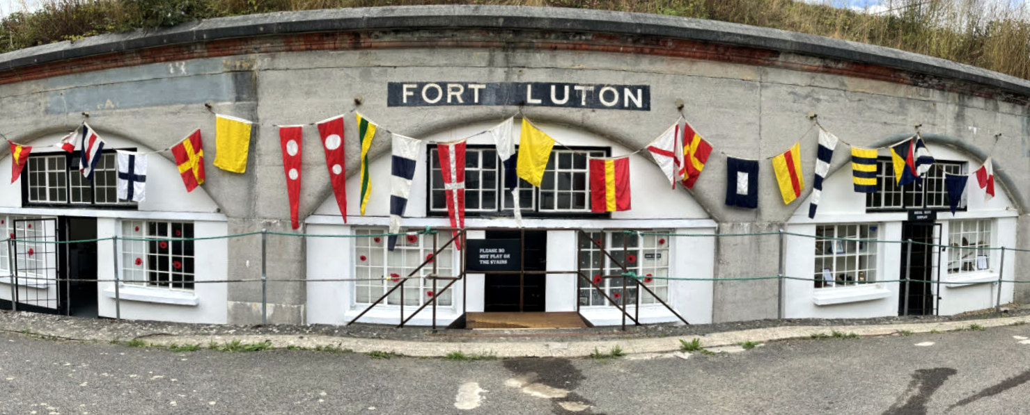
Fort Luton

Fort Luton was built between 1876 and 1892 south of Chatham, Medway, South East England. It is one of the five late Victorian land front forts built to...

Chatham Grammar School for Girls

Chatham Grammar School for Girls ("CGSG") is a girls grammar school with academy status and a mixed sixth form. In September 2017 it became a member school...

Jezreel's tower

Jezreel's Tower (also known as Jezreel's Temple) was built in Gillingham, Kent, England, by a religious sect founded by James Jershom Jezreel in the 1880s...

Medway Maritime Hospital

Medway Maritime Hospital is a general hospital in Gillingham, England within the NHS South East Coast. It is run by Medway NHS Foundation Trust. It is...

Hempstead, Kent

Hempstead is a village near Gillingham, Kent in South East England. Historically a small hamlet, Hempstead grew throughout the 20th century to become part...

Gillingham Fair fire disaster

The Gillingham Fair fire disaster (also known as the Fireman's Wedding disaster) occurred on 11 July 1929 in Gillingham, Kent, England, when a firefighting...

Nearby Amenities

Located within 500m of 51.369131,0.540295
Luton
Place: suburb
Source: npe
Lat/Long: 51.3689842/0.547464
Mini Roundabout
Direction: clockwise
Lat/Long: 51.3689189/0.5464423
M001
Lat/Long: 51.3664402/0.5450487
Turning Circle
Lat/Long: 51.3668685/0.5430862
Turning Circle
Lat/Long: 51.3683416/0.5431466
Bus Stop
Street End Road
Naptan AtcoCode: 249000000189
Naptan Bearing: SW
Naptan CommonName: Street End Road
Naptan Indicator: SW-bound
Naptan Landmark: Allotments
Naptan NaptanCode: chadpma
Naptan PlusbusZoneRef: MEDWAY
Naptan Street: Street End Road
Naptan Verified: no
Source: naptan_import
Lat/Long: 51.3660867/0.5394817
Bus Stop
Street End Road
Naptan AtcoCode: 249000000192
Naptan Bearing: NE
Naptan CommonName: Street End Road
Naptan Indicator: NE-bound
Naptan Landmark: Allotments
Naptan NaptanCode: chadpmj
Naptan PlusbusZoneRef: MEDWAY
Naptan Street: Street End Road
Naptan Verified: no
Source: naptan_import
Lat/Long: 51.3659198/0.5388834
Bus Stop
Mill Lane
Bus: yes
Naptan AtcoCode: 249000000193
Naptan Bearing: NE
Naptan CommonName: Mill Lane
Naptan Indicator: opp
Naptan Landmark: Mill Lane
Naptan NaptanCode: chadpmp
Naptan PlusbusZoneRef: MEDWAY
Naptan Street: Street End Road
Naptan Verified: no
Public Transport: platform
Source: naptan_import
Lat/Long: 51.3679287/0.542874
Bus Stop
Mill Lane
Bus: yes
Naptan AtcoCode: 249000000194
Naptan Bearing: SW
Naptan CommonName: Mill Lane
Naptan Indicator: adj
Naptan Landmark: Mill Lane
Naptan NaptanCode: chadpmt
Naptan PlusbusZoneRef: MEDWAY
Naptan Street: Street End Road
Naptan Verified: no
Public Transport: platform
Source: naptan_import
Lat/Long: 51.3677776/0.5427938
Bus Stop
Hen & Chicks
Bus: yes
Naptan AtcoCode: 249000000226
Naptan Bearing: S
Naptan CommonName: Hen & Chicks
Naptan Indicator: adj
Naptan Landmark: Hen & Chicks PH
Naptan NaptanCode: chadtaj
Naptan PlusbusZoneRef: MEDWAY
Naptan Street: Luton High Street
Naptan Verified: no
Public Transport: platform
Source: naptan_import
Lat/Long: 51.369475/0.5474571
Bus Stop
Albany Road
Bus: yes
Naptan AtcoCode: 249000000729
Naptan Bearing: NW
Naptan CommonName: Albany Road
Naptan Indicator: adj
Naptan Landmark: York Hill
Naptan NaptanCode: chajapt
Naptan PlusbusZoneRef: MEDWAY
Naptan Street: Luton Road
Naptan Verified: no
Public Transport: platform
Source: naptan_import
Lat/Long: 51.373275/0.5419931
Bus Stop
Luton Junior School
Bus: yes
Naptan AtcoCode: 249000000730
Naptan Bearing: NW
Naptan CommonName: Brickmakers Arms
Naptan Indicator: opp
Naptan Landmark: Brickmakers Arms PH
Naptan NaptanCode: chajapw
Naptan PlusbusZoneRef: MEDWAY
Naptan Street: Luton Road
Naptan Verified: no
Public Transport: platform
Source: naptan_import
Lat/Long: 51.3722699/0.5438331
Bus Stop
Luton Junior School
Bus: yes
Naptan AtcoCode: 249000000731
Naptan Bearing: SE
Naptan CommonName: Brickmakers Arms
Naptan Indicator: adj
Naptan Landmark: Brickmakers Arms PH
Naptan NaptanCode: chajata
Naptan PlusbusZoneRef: MEDWAY
Naptan Street: Luton Road
Naptan Verified: no
Public Transport: platform
Source: naptan_import
Lat/Long: 51.3720016/0.5445942
Bus Stop
Upper Luton Road
Bus: yes
Naptan AtcoCode: 249000000732
Naptan Bearing: NW
Naptan CommonName: Upper Luton Road
Naptan Indicator: opp
Naptan Landmark: Upper Luton Road
Naptan NaptanCode: chajatd
Naptan PlusbusZoneRef: MEDWAY
Naptan Street: Luton Road
Naptan Verified: no
Public Transport: platform
Source: naptan_import
Lat/Long: 51.3711405/0.5461414
Bus Stop
Upper Luton Road
Bus: yes
Naptan AtcoCode: 249000000733
Naptan Bearing: S
Naptan CommonName: Upper Luton Road
Naptan Indicator: adj
Naptan Landmark: Upper Luton Road
Naptan NaptanCode: chajatg
Naptan PlusbusZoneRef: MEDWAY
Naptan Street: Luton Road
Naptan Verified: no
Public Transport: platform
Source: naptan_import
Lat/Long: 51.3706669/0.5467769
Bus Stop
Hen & Chicks
Bus: yes
Naptan AtcoCode: 249000000734
Naptan Bearing: NW
Naptan CommonName: Hen & Chicks
Naptan Indicator: opp
Naptan Landmark: Hen & Chicks PH
Naptan NaptanCode: chajatj
Naptan PlusbusZoneRef: MEDWAY
Naptan Street: High Street
Naptan Verified: no
Public Transport: platform
Source: naptan_import
Lat/Long: 51.3700317/0.5470857
Bus Stop
Albany Road
Bus: yes
Naptan AtcoCode: 249000000852
Naptan Bearing: SE
Naptan CommonName: Albany Road
Naptan Indicator: opp
Naptan Landmark: York Hill
Naptan NaptanCode: chajmaj
Naptan PlusbusZoneRef: MEDWAY
Naptan Street: Luton Road
Naptan Verified: no
Public Transport: platform
Source: naptan_import
Lat/Long: 51.3732852/0.5422225
Post Office
Luton Post Office
Source: OS OpenData StreetView
Lat/Long: 51.3695291/0.5472221
Traffic Signals
Crossing: traffic_signals
Crossing Ref: pelican
Lat/Long: 51.369405/0.54718
Post Box
Addr Street: Luton High Street
Collection Times: Mo-Fr 17:15; Sa 12:15
Operator: Royal Mail
Post Box Type: pillar
Ref: ME5 96
Royal Cypher: EIIR
Royal Cypher Wikidata: Q33102113
Source: survey
Lat/Long: 51.3695897/0.5473124
Post Box
Addr Street: Luton Road
Operator: Royal Mail
Post Box Type: wall
Ref: ME4 34D
Lat/Long: 51.3722911/0.543688
Post Box
Addr Street: Albany Road
Operator: Royal Mail
Post Box Type: lamp
Ref: ME4 442D
Lat/Long: 51.3712973/0.5399972
Post Box
Addr Street: Mill Lane
Operator: Royal Mail
Post Box Type: pillar
Ref: ME5 39D
Lat/Long: 51.3667722/0.5443291
Post Box
Addr Street: Shipwrights Avenue
Operator: Royal Mail
Post Box Type: lamp
Ref: ME4 396D
Lat/Long: 51.3707172/0.5350447
Post Box
Operator: Royal Mail
Post Box Type: lamp
Ref: ME5 36D
Lat/Long: 51.3683156/0.5431697
Pharmacy
Delmergate Pharmacy
Addr City: Chatham
Addr Country: GB
Addr County: Kent
Addr Housenumber: 23
Addr Postcode: ME5 0AA
Addr Street: Street End Road
Dispensing: yes
Operator: Delmergate Ltd
Lat/Long: 51.3682376/0.5444837
Doctors
Stonecross Surgery
Wheelchair: yes
Lat/Long: 51.3681107/0.5446767
Traffic Calming: table
Lat/Long: 51.3718926/0.5445103
Traffic Calming: table
Lat/Long: 51.3722753/0.5440686
Traffic Calming: table
Lat/Long: 51.3723405/0.5436598
Traffic Calming: table
Lat/Long: 51.3726979/0.5429909
Traffic Calming: table
Lat/Long: 51.3730556/0.5423267
Traffic Calming: table
Lat/Long: 51.3733464/0.5421099
Best-one
Brand: Best-one
Brand Wikidata: Q4896532
Brand Wikipedia: en:Best-one
Contact Website: https://stores.best-one.co.uk/best-one-8aa1ca680aad
Level: 0
Shop: convenience
Lat/Long: 51.3723239/0.5441025
Addr Housenumber: 43-45
Addr Postcode: ME5 7LP
Addr Street: Luton High Street
Lat/Long: 51.3693861/0.5474379
Haywards Cars Direct
Brand: Renault
Shop: car
Lat/Long: 51.3709797/0.5458017
Fast Food
Famous Fried Chicken
Addr City: Chatham
Addr Housenumber: 268
Addr Place: Luton
Addr Postcode: ME4 5BS
Addr Street: Luton Road
Cuisine: chicken
Fhrs Authority: Medway
Fhrs Id: 947266
Fhrs Inspectiondate: 2017-02-16
Fhrs Rating: 5
Level: 0
Takeaway: only
Lat/Long: 51.3731266/0.5421594
Skarks 2 Shubunkins aquatic centre
Level: 0
Shop: pet
Lat/Long: 51.3734453/0.5419057
Barney's Bikes
Shop: motorcycle
Lat/Long: 51.3729878/0.5424487
The Kabin
Addr City: Chatham
Addr Country: GB
Addr County: Kent
Addr Housenumber: 270
Addr Postcode: ME4 5BS
Addr Street: Luton Road
Brand: Premier
Brand Wikidata: Q7240340
Fhrs Authority: Medway
Fhrs Id: 1086792
Level: 0
Operator: Premier
Shop: convenience
Source Addr: FHRS Open Data
Lat/Long: 51.3731161/0.5422286
Jolene's Nail & Beauty Bar
Level: 0
Shop: beauty
Wheelchair: no
Lat/Long: 51.3693546/0.5473884
Profile Hair Design
Female: yes
Level: 0
Male: no
Shop: hairdresser
Unisex: no
Lat/Long: 51.3694721/0.5470283
Magnolija shop
Addr City: Chatham
Addr Housenumber: 308
Addr Place: Luton
Addr Postcode: ME4 5BX
Addr Street: Luton Road
Fhrs Authority: Medway
Fhrs Id: 814447
Fhrs Inspectiondate: 2016-09-29
Fhrs Rating: 4
Level: 0
Shop: convenience
Lat/Long: 51.3722791/0.5437304
Fast Food
Turkish Delight
Addr City: Chatham
Addr Housenumber: 290
Addr Postcode: ME4 5BU
Addr Street: Luton Road
Cuisine: burger;kebab;pizza
Fhrs Authority: Medway
Fhrs Id: 580477
Fhrs Inspectiondate: 2015-07-27
Fhrs Rating: 5
Level: 0
Takeaway: only
Lat/Long: 51.3727258/0.5429323
Childcare
Addr Postcode: ME4 5DL
Fhrs Authority: Medway
Fhrs Id: 716252
Fhrs Inspectiondate: 2014-11-07
Fhrs Rating: 4
Level: 0
Lat/Long: 51.3715895/0.5461556
Fast Food
Open Rice
Addr City: Chatham
Addr Housenumber: 291
Addr Place: Luton
Addr Postcode: ME4 5BL
Addr Street: Luton Road
Cuisine: chinese
Fhrs Authority: Medway
Fhrs Id: 656579
Fhrs Inspectiondate: 2016-02-18
Fhrs Rating: 4
Level: 0
Takeaway: only
Lat/Long: 51.3733587/0.5422751
Martin's
Addr Housenumber: 49
Addr Postcode: ME5 7LP
Addr Street: Luton High Street
Brand: Martin's
Brand Wikidata: Q116779207
Brand Wikipedia: en:McColl's
Fhrs Authority: Medway
Fhrs Id: 786146
Fhrs Inspectiondate: 2015-08-14
Fhrs Rating: 5
Level: 0
Shop: newsagent
Wheelchair: no
Lat/Long: 51.3693291/0.5472444
Day Today Off Licence and Real Ale Centre
Addr Housenumber: 72
Addr Postcode: ME4 5DN
Addr Street: Albany Road
Fhrs Authority: Medway
Fhrs Id: 732151
Fhrs Inspectiondate: 2016-07-26
Fhrs Rating: 3
Level: 0
Shop: convenience
Lat/Long: 51.3718461/0.5405114
Community Centre
Tramways Community Centre
Operator: Orbit Housing
Lat/Long: 51.3706732/0.5462429
School
All Saints Children's Centre
Addr Housename: Community Centre
Addr Housenumber: 2
Addr Place: Luton
Addr Postcode: ME5 7LS
Addr Street: Tramways
Fhrs Authority: Medway
Fhrs Id: 571993
Fhrs Inspectiondate: 2015-02-06
Fhrs Rating: 5
Kindergarten: yes
Nursery: yes
Operator: Medway Council
Operator Type: government
Operator Wikidata: Q16997526
Lat/Long: 51.37069/0.5462978
Grit Bin
Access: yes
Operator: Medway Council
Ref: SB356
Source: survey
Lat/Long: 51.368881/0.5440284
Grit Bin
Access: yes
Operator: Medway Council
Ref: SB317
Source: survey
Lat/Long: 51.3675925/0.5464089
Grit Bin
Access: yes
Operator: Medway Council
Ref: SB268
Source: survey
Lat/Long: 51.366828/0.5443275
Grit Bin
Access: yes
Operator: Medway Council
Ref: SB271
Source: survey
Lat/Long: 51.3664554/0.5418129
Grit Bin
Access: yes
Ref: SB045
Source: survey
Lat/Long: 51.3697476/0.5332553
Grit Bin
Access: yes
Ref: SB392
Source: survey
Lat/Long: 51.3702918/0.5339393
Grit Bin
Access: yes
Ref: SB044
Source: survey
Lat/Long: 51.3715091/0.5369809
Grit Bin
Access: yes
Ref: SB019
Source: survey
Lat/Long: 51.3724819/0.5364767
Grit Bin
Access: yes
Ref: SB327
Source: survey
Lat/Long: 51.3721236/0.535841
Grit Bin
Access: yes
Ref: SB018
Source: survey
Lat/Long: 51.3729725/0.5372626
Grit Bin
Access: yes
Ref: SB0033
Source: survey
Lat/Long: 51.3708352/0.5393238
Grit Bin
Access: yes
Ref: SB006
Source: survey
Lat/Long: 51.3706083/0.5421549
Grit Bin
Access: yes
Ref: SB007
Source: survey
Lat/Long: 51.3724342/0.5444361
Medway Soft Drinks Ltd
Addr City: Chatham
Addr Country: GB
Addr Postcode: ME4 5AU
Addr Street: Second Avenue
Contact Phone: +44 1634 827333
Lat/Long: 51.3699385/0.544365
Plastic Data Card Ltd
Addr City: Chatham
Addr Country: GB
Addr Housename: Dajen Business Park
Addr Postcode: ME4 5AU
Addr Street: Second Avenue
Contact Email: sales@plasticdatacard.co.uk
Contact Phone: +44 1634 811455
Contact Website: http://www.plasticdatacard.co.uk
Lat/Long: 51.3696957/0.5438822
Frost Signs & Graphics
Addr City: Chatham
Addr Country: GB
Addr Housename: Dajen Business Park
Addr Postcode: ME4 5AU
Addr Street: Second Avenue
Contact Email: info@frostsigns.co.uk
Contact Phone: +44 1634 290111
Contact Website: http://www.frostsigns.co.uk
Craft: signmaker
Lat/Long: 51.369612/0.5437213
TKO Elite
Addr City: Chatham
Addr Country: GB
Addr Housename: Dajen Business Park
Addr Postcode: ME4 5AU
Addr Street: Second Avenue
Addr Unit: 2
Contact Email: info@tkoelite.co.uk
Contact Phone: +44 7912 577773
Contact Website: http://www.tkoelite.co.uk/
Leisure: fitness_centre
Lat/Long: 51.369612/0.5439627
MCDA Allstars
Addr City: Chatham
Addr Country: GB
Addr Housename: Dajen Business Park
Addr Postcode: ME4 5AU
Addr Street: Second Avenue
Addr Unit: 3
Contact Email: info@mcda-allstars.com
Contact Phone: +44 7830 309505
Contact Website: http://www.mcda-allstars.com/
Lat/Long: 51.36954/0.5440485
OnPoint. Flooring
Addr City: Chatham
Addr Country: GB
Addr Housename: Dajen Business Park
Addr Postcode: ME4 5AU
Addr Street: Second Avenue
Addr Unit: 5
Shop: flooring
Lat/Long: 51.3694412/0.5440807
Freelance Mazda
Addr City: Chatham
Addr Country: GB
Addr Housenumber: 33-37
Addr Postcode: ME4 5AY
Addr Street: Second Avenue
Brand: Mazda
Contact Phone: +44 1634 829444
Contact Website: http://www.freelancemazda.co.uk
Service: parts;repair;tyres
Shop: car_repair
Lat/Long: 51.3692168/0.5435389
Place Of Worship
Endtime Evangelical Church
Addr City: Chatham
Addr Country: GB
Addr Housename: Zion House
Addr Housenumber: 33-37
Addr Postcode: ME4 5AY
Addr Street: Second Avenue
Contact Email: eeczionhouse1@btconnect.com
Contact Phone: +44 1634 400111
Contact Website: https://www.eeczionhouse.com/
Religion: christian
Lat/Long: 51.3693173/0.5432948
Car Rental
Hire 4 Medway
Addr City: Chatham
Addr Country: GB
Addr Housenumber: 33-37
Addr Postcode: ME4 5AY
Addr Street: Second Avenue
Addr Unit: D
Contact Email: hire@hire4medway.com
Contact Phone: +44 1634 409617
Contact Website: http://www.hire4medway.com
Lat/Long: 51.3691532/0.5431178
J & A Precision Engineering
Addr City: Chatham
Addr Country: GB
Addr Housenumber: 33-37
Addr Postcode: ME4 5AY
Addr Street: Second Avenue
Addr Unit: B
Contact Email: mail@jandaprecisioneng.co.uk
Contact Fax: +44 1634 832115
Contact Phone: +44 1634 406727
Contact Website: http://www.jandaprecisioneng.co.uk/
Craft: engineering
Lat/Long: 51.3688919/0.5431715
Enroute Couriers
Addr City: Chatham
Addr Country: GB
Addr Housenumber: 33-37
Addr Postcode: ME4 5AU
Addr Street: Second Avenue
Lat/Long: 51.3689773/0.5429462
Medway Joinery Ltd
Addr City: Chatham
Addr Country: GB
Addr Housenumber: 59
Addr Postcode: ME4 5AU
Addr Street: Second Avenue
Contact Phone: +44 1634 828261
Craft: carpenter
Lat/Long: 51.3674669/0.541133
Childcare
Crestway Pre-School
Addr City: Chatham
Addr Housename: Stonecross Lea Community Centre
Addr Postcode: ME5 0BL
Addr Street: Stonecross Lea
Addr Suburb: Wayfield
Fhrs Authority: Medway
Fhrs Id: 802080
Fhrs Inspectiondate: 2015-09-09
Fhrs Rating: 5
Lat/Long: 51.3659044/0.5416948
Addr Flats: 10-15
Entrance: home
Lat/Long: 51.3698675/0.5470331
Addr Flats: 1-9
Entrance: home
Lat/Long: 51.369782/0.5471282
Car Wash
Valeting Center
Lat/Long: 51.3693308/0.5465397
Majestic Ventures Ltd
Shop: car_repair
Lat/Long: 51.3692433/0.5464259
J & S Plumbing & Heating Centre
Shop: doityourself
Lat/Long: 51.3715371/0.545693
Downsview Digital One
Addr Postcode: ME5 0AR
Office: it
Lat/Long: 51.3660184/0.544552
Ethels Tea
Lat/Long: 51.3659571/0.5445681
Barrier: lift_gate
Lat/Long: 51.3678067/0.5415733
Generator Method: photovoltaic
Generator Output Electricity: yes
Generator Source: solar
Generator Type: solar_photovoltaic_panel
Location: roof
Power: generator
Lat/Long: 51.3674409/0.5426873
Generator Method: photovoltaic
Generator Output Electricity: yes
Generator Source: solar
Generator Type: solar_photovoltaic_panel
Location: roof
Power: generator
Lat/Long: 51.3675908/0.5430213
Generator Method: photovoltaic
Generator Output Electricity: yes
Generator Source: solar
Generator Type: solar_photovoltaic_panel
Location: roof
Power: generator
Lat/Long: 51.3680371/0.5436368
Generator Method: photovoltaic
Generator Output Electricity: yes
Generator Source: solar
Generator Type: solar_photovoltaic_panel
Location: roof
Power: generator
Lat/Long: 51.3688836/0.5454057
Generator Method: photovoltaic
Generator Output Electricity: yes
Generator Source: solar
Generator Type: solar_photovoltaic_panel
Location: roof
Power: generator
Lat/Long: 51.3689037/0.5455023
Generator Method: photovoltaic
Generator Output Electricity: yes
Generator Source: solar
Generator Type: solar_photovoltaic_panel
Location: roof
Power: generator
Lat/Long: 51.3726594/0.543386
Generator Method: photovoltaic
Generator Output Electricity: yes
Generator Source: solar
Generator Type: solar_photovoltaic_panel
Location: roof
Power: generator
Lat/Long: 51.3723095/0.5426632
Generator Method: photovoltaic
Generator Output Electricity: yes
Generator Source: solar
Generator Type: solar_photovoltaic_panel
Location: roof
Power: generator
Lat/Long: 51.372266/0.5426189
Generator Method: photovoltaic
Generator Output Electricity: yes
Generator Source: solar
Generator Type: solar_photovoltaic_panel
Location: roof
Power: generator
Lat/Long: 51.3699854/0.5394056
Generator Method: photovoltaic
Generator Output Electricity: yes
Generator Source: solar
Generator Type: solar_photovoltaic_panel
Location: roof
Power: generator
Lat/Long: 51.3716129/0.5370265
Generator Method: photovoltaic
Generator Output Electricity: yes
Generator Source: solar
Generator Type: solar_photovoltaic_panel
Location: roof
Power: generator
Lat/Long: 51.3657002/0.5438501
Generator Method: photovoltaic
Generator Output Electricity: yes
Generator Source: solar
Generator Type: solar_photovoltaic_panel
Location: roof
Power: generator
Lat/Long: 51.3656014/0.5441532
Generator Method: photovoltaic
Generator Output Electricity: yes
Generator Source: solar
Generator Type: solar_photovoltaic_panel
Location: roof
Power: generator
Lat/Long: 51.3650094/0.5374999
Generator Method: photovoltaic
Generator Output Electricity: yes
Generator Source: solar
Generator Type: solar_photovoltaic_panel
Location: roof
Power: generator
Lat/Long: 51.3650061/0.5375536
Entrance: yes
Lat/Long: 51.3719052/0.5439017
Entrance: yes
Lat/Long: 51.3705535/0.5423363
Entrance: yes
Lat/Long: 51.3719858/0.5439919
Entrance: yes
Lat/Long: 51.3718688/0.5438123
Entrance: yes
Lat/Long: 51.3715528/0.5439672
Entrance: yes
Lat/Long: 51.3705781/0.5351218
Entrance: yes
Lat/Long: 51.371552/0.5438063
Entrance: yes
Lat/Long: 51.3710858/0.5431389
Playground: climbingframe
Lat/Long: 51.3720767/0.5441171
Playground: climbingframe
Lat/Long: 51.3720291/0.5441981
Playground: climbingframe
Lat/Long: 51.372015/0.5442662
Playground: climbingframe
Lat/Long: 51.3719082/0.5443306
Entrance: yes
Lat/Long: 51.3714776/0.5438036
Entrance: yes
Lat/Long: 51.3714023/0.5437094
Entrance: yes
Lat/Long: 51.3714094/0.5433208
Entrance: yes
Lat/Long: 51.3712721/0.5431445
Entrance: yes
Lat/Long: 51.3709392/0.5427856
Entrance: yes
Lat/Long: 51.3708169/0.5425863
Playground: climbingframe
Lat/Long: 51.3705108/0.5425369
Playground: climbingframe
Lat/Long: 51.3706012/0.5426544
Entrance: yes
Lat/Long: 51.3714611/0.546231
The data included in this document is from www.openstreetmap.org. The data is made available under ODbL.

Have you been to Luton?

Leave your review of Luton below (or comments, questions and feedback).