Sgeirean na Giusaich

Island in Argyllshire

Scotland

Sgeirean na Giusaich

Lunga (Treshnish Isles) from Arinagour, Coll Looking due south from <a href="https://www.geograph.org.uk/photo/7238968">NM2257 : Coll - Arinagour - Coll Hotel gardens</a> over Arinagour's harbour to Lunga, the largest of the Treshnish Isles. The green starboard buoy seen in mid distance is at NM23075566 (see <a href="https://www.geograph.org.uk/photo/3924955">NM2355 : Bogha Mor and marker buoy</a> for a close view).
Lunga (Treshnish Isles) from Arinagour, Coll Credit: Rob Farrow

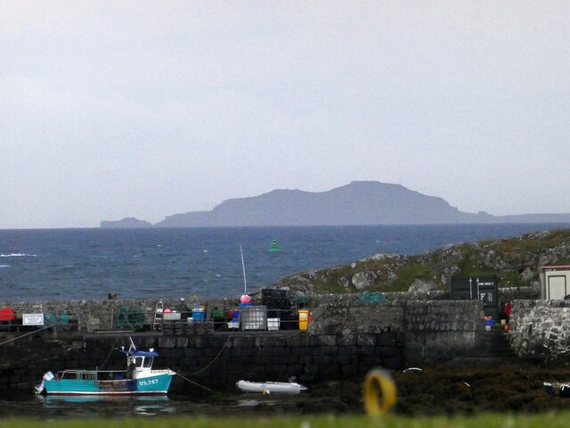
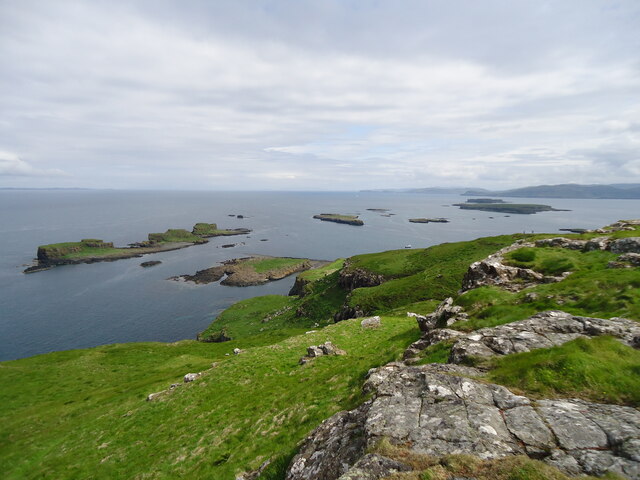
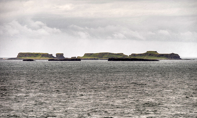
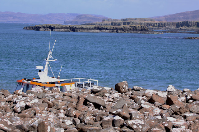
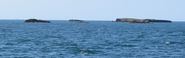
Sgeirean na Giusaich is a group of small islands located off the west coast of Scotland, specifically in Argyllshire. It is situated in the Inner Hebrides, an archipelago known for its rugged landscapes and beautiful natural scenery. The islands are uninhabited and are part of a nature reserve, making them an important site for wildlife conservation.

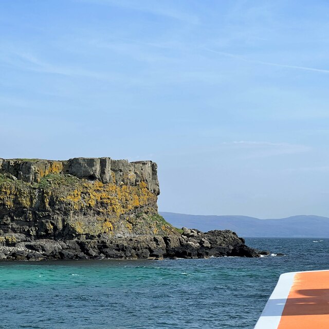
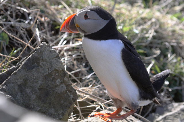
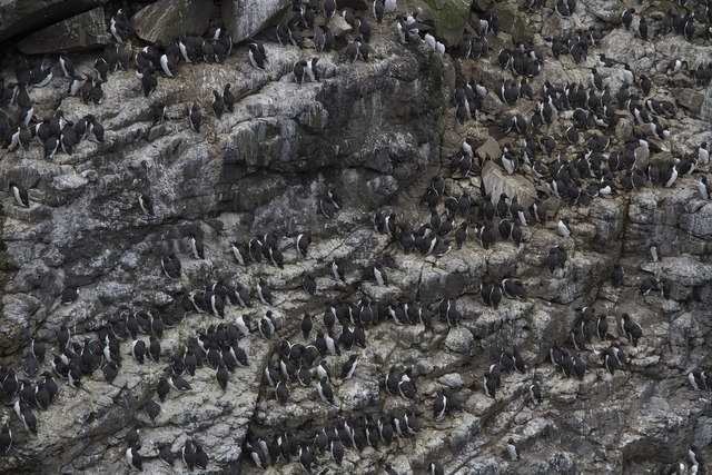
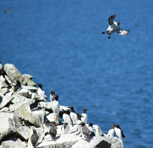
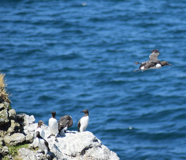
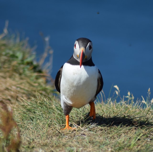
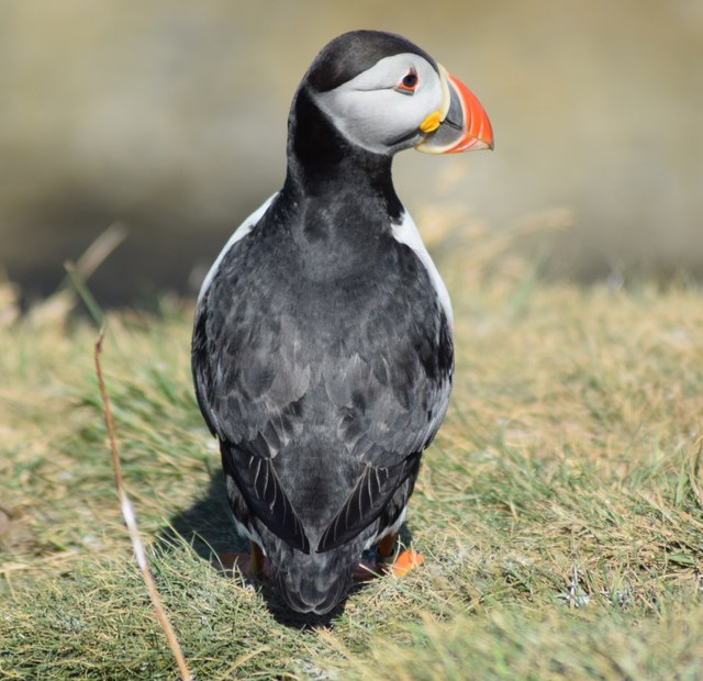
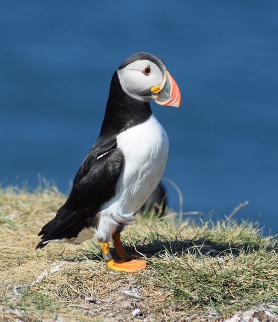
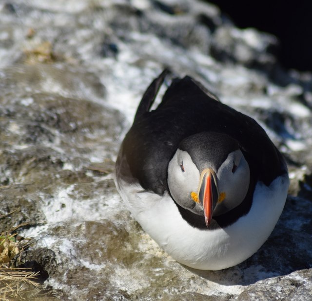
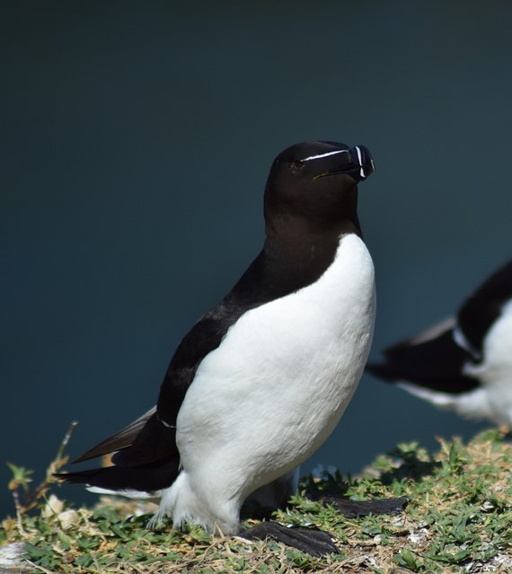
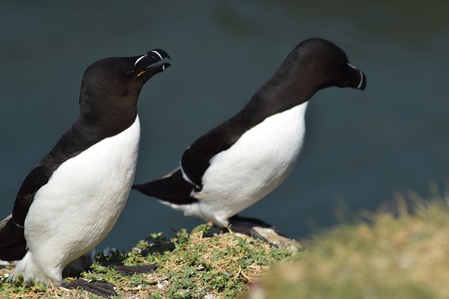
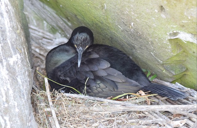
The name "Sgeirean na Giusaich" translates to "the skerries of Giusaich" in English. Skerries are rocky islets that are often found in coastal areas, and they are a prominent feature of these islands. The coastline is characterized by dramatic cliffs and rocky outcrops, which provide nesting sites for various seabird species, including guillemots, razorbills, and puffins.

The islands are also home to a diverse range of marine life. The surrounding waters are teeming with fish, making it an ideal location for fishing enthusiasts. Seals can often be spotted basking on the rocks, while dolphins and porpoises occasionally make appearances in the area.

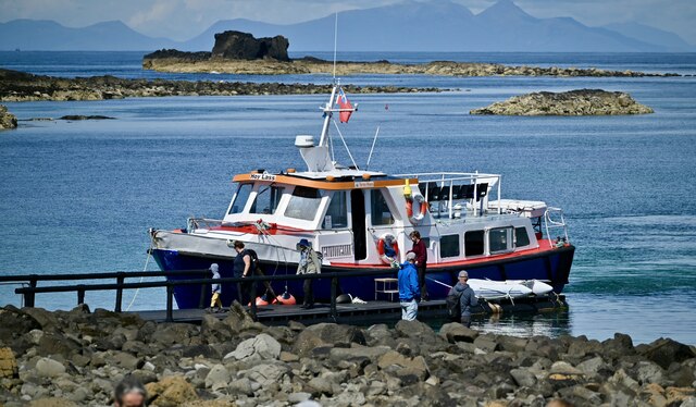
Access to Sgeirean na Giusaich is limited due to their remote location and lack of infrastructure. However, boat trips and guided tours are available for those interested in exploring the islands and observing the wildlife. Visitors are advised to take precautions and adhere to the conservation guidelines in order to minimize any potential impact on the delicate ecosystem.

Overall, Sgeirean na Giusaich offers a unique opportunity to experience the untamed beauty of the Scottish coastline and witness the wonders of the natural world.

If you have any feedback on the listing, please let us know in the comments section below.

Sgeirean na Giusaich Images

Images are sourced within 2km of 56.498504/-6.4096451 or Grid Reference NM2842. Thanks to Geograph Open Source API. All images are credited.

Lunga (Treshnish Isles) from Arinagour, Coll Looking due south from <a href="https://www.geograph.org.uk/photo/7238968">NM2257 : Coll - Arinagour - Coll Hotel gardens</a> over Arinagour's harbour to Lunga, the largest of the Treshnish Isles. The green starboard buoy seen in mid distance is at NM23075566 (see <a href="https://www.geograph.org.uk/photo/3924955">NM2355 : Bogha Mor and marker buoy</a> for a close view).
Lunga (Treshnish Isles) from Arinagour, Coll
Looking due south from NM2257 : Coll - Arinagour - Coll Hotel gardens over Arinagour's harbour to Lunga, the largest of the Treshnish Isles. The green starboard buoy seen in mid distance is at NM23075566 (see NM2355 : Bogha Mor and marker buoy for a close view).
Cruachan, the summit of Lunga, Treshnish Isles We are looking just east of north. On the left is Sgeir a' Chaisteil and smaller islands, and the largest, flat-looking island is Fladda in <a href="https://www.geograph.org.uk/gridref/NM2943">NM2943</a>. More distant are part of west Mull, and Ardnamurchan Point.
Cruachan, the summit of Lunga, Treshnish Isles
We are looking just east of north. On the left is Sgeir a' Chaisteil and smaller islands, and the largest, flat-looking island is Fladda in NM2943. More distant are part of west Mull, and Ardnamurchan Point.
'Hoy Lass' at a landing place on Lunga, Treshnish Isles The 'Hoy Lass' operated by Turus Mara at a place where they disemark and embark passengers on Lunga.   Treshnish Isles are an SSSI, see <span class="nowrap"><a title="https://sitelink.nature.scot/site/1562" rel="nofollow ugc noopener" href="https://sitelink.nature.scot/site/1562">Link</a><img style="margin-left:2px;" alt="External link" title="External link - shift click to open in new window" src="https://s1.geograph.org.uk/img/external.png" width="10" height="10"/></span>
'Hoy Lass' at a landing place on Lunga, Treshnish Isles
The 'Hoy Lass' operated by Turus Mara at a place where they disemark and embark passengers on Lunga. Treshnish Isles are an SSSI, see LinkExternal link
Southern tip of Fladda The Staffa tour boat threaded its way through the Treshnish Isles on its return journey to Kilchoan and Tobermory.
Southern tip of Fladda
The Staffa tour boat threaded its way through the Treshnish Isles on its return journey to Kilchoan and Tobermory.
Treshnish Islands, Lunga Of volcanic origin, the island of Lunga is the largest of the Treshnish Isles in the Inner Hebrides. During the summer, tourist boats visit Lunga; the main attraction is the many thousands of breeding puffins as well as the abundant plant life for which it has been designated as a Site of Special Scientific Interest. One such boat, operated by the Staffa Tours company can be seen moored at the southern end of the Island in this photograph.
Treshnish Islands, Lunga
Of volcanic origin, the island of Lunga is the largest of the Treshnish Isles in the Inner Hebrides. During the summer, tourist boats visit Lunga; the main attraction is the many thousands of breeding puffins as well as the abundant plant life for which it has been designated as a Site of Special Scientific Interest. One such boat, operated by the Staffa Tours company can be seen moored at the southern end of the Island in this photograph.
Lunga landing There is no permanent pier on Lunga. The boatman has a temporary floating pier that is pushed against the shore between the boat and the rocks. Depending on the state of the tide you may have to scramble across slippery, rounded seaweed covered rocks to get to the shore proper.
Lunga landing
There is no permanent pier on Lunga. The boatman has a temporary floating pier that is pushed against the shore between the boat and the rocks. Depending on the state of the tide you may have to scramble across slippery, rounded seaweed covered rocks to get to the shore proper.
Puffin on Lunga One of very many Puffin that nest in burrows on Lunga. If you sit still they will approach you getting well within arms reach. This is a really exciting experience.
Puffin on Lunga
One of very many Puffin that nest in burrows on Lunga. If you sit still they will approach you getting well within arms reach. This is a really exciting experience.
The wildlife of Lunga This cliff is crowded with Razorbills and Guillemot all trying to find a small space in which to lay their eggs. We came here two years ago just one week earlier and the only birds on the island were the Puffin and a few Shag. The Razorbills etc. had not arrived to start nesting.
The wildlife of Lunga
This cliff is crowded with Razorbills and Guillemot all trying to find a small space in which to lay their eggs. We came here two years ago just one week earlier and the only birds on the island were the Puffin and a few Shag. The Razorbills etc. had not arrived to start nesting.
Treshnish Isles - Unnamed islets NW of Bogha Ruadh As our boat threaded through the myriad islets of the Treshnish Islands this was the view back northwards. The large island in the background is Fladda while the islets associated with Bogha Ruadh are in the foreground.
Treshnish Isles - Unnamed islets NW of Bogha Ruadh
As our boat threaded through the myriad islets of the Treshnish Islands this was the view back northwards. The large island in the background is Fladda while the islets associated with Bogha Ruadh are in the foreground.
Coming in to Land - Harp Rock, Lunga There is a huge colony of guillemots (Uria aalge) and razorbills (Alca torda) nesting on Harp Rock off the western coast of the island of Lunga, the largest of the Treshnish Islands. Amongst these two species are also a number of puffins, although they generally prefer the grassier slopes of the main island. There were also a variety of gulls about.
Here a guillemot (I think) is coming in to land on the edge of this rock. The guillemots are slightly slenderer than the razorbills and have pointier bills. The razorbills have a distinctive diagonal stripe towards the tip of their bills as can be seen on the bird at bottom right.
Coming in to Land - Harp Rock, Lunga
There is a huge colony of guillemots (Uria aalge) and razorbills (Alca torda) nesting on Harp Rock off the western coast of the island of Lunga, the largest of the Treshnish Islands. Amongst these two species are also a number of puffins, although they generally prefer the grassier slopes of the main island. There were also a variety of gulls about. Here a guillemot (I think) is coming in to land on the edge of this rock. The guillemots are slightly slenderer than the razorbills and have pointier bills. The razorbills have a distinctive diagonal stripe towards the tip of their bills as can be seen on the bird at bottom right.
A guillemot takes flight One of the thousands of guillemots (Uria aalge) nesting on Harp Rock, Lunga Island, takes flight on a mission to catch fish (mainly sand eels). See also <a href="https://www.geograph.org.uk/photo/5834320">NM2742 : Coming in to Land - Harp Rock, Lunga</a> for more information.
A guillemot takes flight
One of the thousands of guillemots (Uria aalge) nesting on Harp Rock, Lunga Island, takes flight on a mission to catch fish (mainly sand eels). See also NM2742 : Coming in to Land - Harp Rock, Lunga for more information.
Puffin (Fratercula arctica) on Lunga (1) A head-on view of one of the very trusting - and photogenic - puffins that nest in their hundreds (probably thousands) on the little island of Lunga in the Treshnish Isles off Mull.
The puffin (Fratercula arctica) shares the island with many other seabirds, in particular guillemots and razorbills which nest in their thousands on the nearby Harp Rock.
Puffin (Fratercula arctica) on Lunga (1)
A head-on view of one of the very trusting - and photogenic - puffins that nest in their hundreds (probably thousands) on the little island of Lunga in the Treshnish Isles off Mull. The puffin (Fratercula arctica) shares the island with many other seabirds, in particular guillemots and razorbills which nest in their thousands on the nearby Harp Rock.
Puffin (Fratercula arctica) on Lunga (2) The puffins on Lunga obligingly waddled about allowing shots from every angle - here the glossy black plumage of its back is seen along with its head in profile.
Puffin (Fratercula arctica) on Lunga (2)
The puffins on Lunga obligingly waddled about allowing shots from every angle - here the glossy black plumage of its back is seen along with its head in profile.
Puffin (Fratercula arctica) on Lunga (3) A side view of one of the many photogenic little puffins on Lunga.
Puffin (Fratercula arctica) on Lunga (3)
A side view of one of the many photogenic little puffins on Lunga.
Puffin (Fratercula arctica) on Lunga (4) This puffin is resting on a ledge on the offshore "Harp Rock" just off the cost of Lunga the largest of the Treshnish Isles.
Puffin (Fratercula arctica) on Lunga (4)
This puffin is resting on a ledge on the offshore "Harp Rock" just off the cost of Lunga the largest of the Treshnish Isles.
Razorbill (Alca torda) on Lunga There are thousands of both razorbills (Alca torda) and guillemots (Uria aalge) on Lunga; most are on the slightly offshore Harp Rock, but a few such as this one were sharing the grassy sides of the main island with the puffins.
The razorbill and guillemot are quite similar, though the former  has a thicker bill with a distinctive diagonal white streak towards its tip.
Razorbill (Alca torda) on Lunga
There are thousands of both razorbills (Alca torda) and guillemots (Uria aalge) on Lunga; most are on the slightly offshore Harp Rock, but a few such as this one were sharing the grassy sides of the main island with the puffins. The razorbill and guillemot are quite similar, though the former has a thicker bill with a distinctive diagonal white streak towards its tip.
Two razorbills (Alca torda) on Lunga These two razorbills (Alca torda) on Lunga were away from the main colony which was on nearby Harp Rock.
See <a href="https://www.geograph.org.uk/photo/5834419">NM2742 : Razorbill (Alca torda) on Lunga</a> for more information.
Two razorbills (Alca torda) on Lunga
These two razorbills (Alca torda) on Lunga were away from the main colony which was on nearby Harp Rock. See NM2742 : Razorbill (Alca torda) on Lunga for more information.
Nesting shag (Phalacrocorax aristotelis) on Lunga A shag (Phalacrocorax aristotelis) seen on its nest in a cleft of the rocks beside the path that leads from the north of the island to Harp Rock.
Nesting shag (Phalacrocorax aristotelis) on Lunga
A shag (Phalacrocorax aristotelis) seen on its nest in a cleft of the rocks beside the path that leads from the north of the island to Harp Rock.
Show me another place!

Sgeirean na Giusaich is located at Grid Ref: NM2842 (Lat: 56.498504, Lng: -6.4096451)

Unitary Authority: Argyll and Bute

Police Authority: Argyll and West Dunbartonshire

What 3 Words

///wordy.nephews.seasonality. Near Calgary, Argyll & Bute

Related Wikis

Treshnish Isles

The Treshnish Isles are an archipelago of small islands and skerries, lying west of the Isle of Mull, in Scotland. They are part of the Inner Hebrides...

Lunga, Treshnish Isles

The island of Lunga is the largest of the Treshnish Isles in Argyll and Bute, Scotland. The Isles are part of the Loch Na Keal National Scenic Area....

Fladda, Treshnish Isles

Fladda is the northernmost of the Treshnish Isles. Its name comes from the Old Norse Flat-ey meaning "flat island". Fladda is owned by the Hebridean Trust...

Cairnburgh Castle

Cairnburgh Castle is a ruined castle that is located on the islands of Cairn na Burgh Mòr and Cairn na Burgh Beag, Argyll and Bute, Scotland. These islands...

Nearby Amenities

Located within 500m of 56.498504,-6.4096451
Source: PGS
Lat/Long: 56.5027088/-6.4104024
Source: PGS
Lat/Long: 56.5023804/-6.4092664
Source: PGS
Lat/Long: 56.5021043/-6.4090635
Source: PGS
Lat/Long: 56.5023437/-6.4101729
Source: PGS
Lat/Long: 56.5023057/-6.4101034
Source: PGS
Lat/Long: 56.5026435/-6.410468
Source: PGS
Lat/Long: 56.5016389/-6.414289
Source: PGS
Lat/Long: 56.5015456/-6.414528
Source: PGS
Lat/Long: 56.5017052/-6.4147174
Source: PGS
Lat/Long: 56.4983743/-6.4073451
Source: PGS
Lat/Long: 56.4985591/-6.4074561
Source: PGS
Lat/Long: 56.499034/-6.4072958
Source: PGS
Lat/Long: 56.4991954/-6.4069177
Source: PGS
Lat/Long: 56.4989758/-6.4066182
Source: PGS
Lat/Long: 56.4986605/-6.4066304
Source: PGS
Lat/Long: 56.4983781/-6.4068577
Source: PGS
Lat/Long: 56.4982752/-6.4072198
Source: PGS
Lat/Long: 56.4974805/-6.4084103
Source: PGS
Lat/Long: 56.4974708/-6.4084749
Source: PGS
Lat/Long: 56.4974908/-6.408554
Source: PGS
Lat/Long: 56.4975595/-6.4087871
Source: PGS
Lat/Long: 56.4977288/-6.4087164
Source: PGS
Lat/Long: 56.4978126/-6.4081509
Source: PGS
Lat/Long: 56.4975786/-6.408063
Source: PGS
Lat/Long: 56.4975378/-6.4081505
Source: PGS
Lat/Long: 56.4990022/-6.4070116
The data included in this document is from www.openstreetmap.org. The data is made available under ODbL.

Have you been to Sgeirean na Giusaich?

Leave your review of Sgeirean na Giusaich below (or comments, questions and feedback).