Dà Bhriomag

Island in Ross-shire

Scotland

Dà Bhriomag

West coast of Great Bernera This is the west side of a spit of land extending south of Tobson. The ground is rocky with a thin covering of grass.

In the distance, on the left is the tip of the island of Pabaigh Mor .. and on the right Geodha Mor (west of Tobson).
West coast of Great Bernera Credit: Rob Burke

Dà Bhriomag is a small island located off the coast of Ross-shire in the Highland region of Scotland. It is situated in the Inner Hebrides, specifically in the Inner Sound, between the mainland and the Isle of Skye. The name "Dà Bhriomag" translates to "two hillocks" in Gaelic, which accurately describes the island's landscape.

Covering an area of approximately 2 square miles, Dà Bhriomag is characterized by its rugged and rocky terrain, with two prominent hills dominating its landscape. The island is uninhabited and lacks any permanent structures or amenities for visitors.

Despite its small size, Dà Bhriomag is notable for its rich biodiversity. The island is home to a variety of bird species, including puffins, guillemots, and razorbills, making it a popular destination for birdwatchers. The surrounding waters are also teeming with marine life, including seals and porpoises.

Access to Dà Bhriomag is mainly by boat, as there are no bridges connecting it to the mainland or other islands. Visitors can enjoy the tranquil and unspoiled nature of the island, taking in the stunning coastal views and exploring its rocky shores. However, it is important to note that there are no facilities or services available on the island, so visitors should come prepared with food, water, and appropriate outdoor gear.

Dà Bhriomag offers a unique opportunity to experience the untamed beauty of the Scottish Highlands and is a haven for nature enthusiasts seeking solitude and natural wonders.

If you have any feedback on the listing, please let us know in the comments section below.
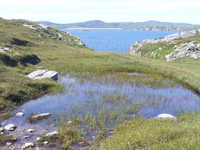
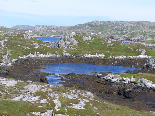
Dà Bhriomag Images

Images are sourced within 2km of 58.225636/-6.8750594 or Grid Reference NB1336. Thanks to Geograph Open Source API. All images are credited.

West coast of Great Bernera This is the west side of a spit of land extending south of Tobson. The ground is rocky with a thin covering of grass.

In the distance, on the left is the tip of the island of Pabaigh Mor .. and on the right Geodha Mor (west of Tobson).
West coast of Great Bernera
This is the west side of a spit of land extending south of Tobson. The ground is rocky with a thin covering of grass. In the distance, on the left is the tip of the island of Pabaigh Mor .. and on the right Geodha Mor (west of Tobson).
Camas Sanndaig Looking across the bay. In the distance is the low island of Pabaigh Mor with the headland of Bhaltos beyond.

A bundle of fencing wire is abandoned in the rocky gully above the sea.
Camas Sanndaig
Looking across the bay. In the distance is the low island of Pabaigh Mor with the headland of Bhaltos beyond. A bundle of fencing wire is abandoned in the rocky gully above the sea.
Beach north of Bhalasaigh
Sea loch west of Loch Veiravat Although it isn't obvious from here, this is the start of a long channel that leads out to the sea.
Sea loch west of Loch Veiravat
Although it isn't obvious from here, this is the start of a long channel that leads out to the sea.
Moorland and loch on Great Bernera The loch is unnamed on the map, but the Allt Loch an Fheoir flows into it, so this must be Loch an Fheoir.

The houses in the distance are on the road south of Bhalasaigh.
Moorland and loch on Great Bernera
The loch is unnamed on the map, but the Allt Loch an Fheoir flows into it, so this must be Loch an Fheoir. The houses in the distance are on the road south of Bhalasaigh.
Waymarked coastal walk There are clear waymarks on the route from the community centre to Bosta on Great Bernera. Return by the same route or on the road.
Waymarked coastal walk
There are clear waymarks on the route from the community centre to Bosta on Great Bernera. Return by the same route or on the road.
Bridge at Bhalasaigh Looking back to the road end on the main island of Great Bernera.
Bridge at Bhalasaigh
Looking back to the road end on the main island of Great Bernera.
West coast of Great Bernera A complicated coastline with many interesting features.
West coast of Great Bernera
A complicated coastline with many interesting features.
Loch Ionail Freshwater loch on the island of Great Bernera / Bearnaraigh.
<span class="nowrap"><a title="http://www.uigandbernera.com/" rel="nofollow ugc noopener" href="http://www.uigandbernera.com/">Link</a><img style="margin-left:2px;" alt="External link" title="External link - shift click to open in new window" src="https://s1.geograph.org.uk/img/external.png" width="10" height="10"/></span>
Loch Ionail
Freshwater loch on the island of Great Bernera / Bearnaraigh. LinkExternal link
Tob Bhalasaigh Tidal lagoon with a mix of rare seaweeds on Great Bernera / Bearnaraigh.
<span class="nowrap"><a title="http://www.uigandbernera.com/" rel="nofollow ugc noopener" href="http://www.uigandbernera.com/">Link</a><img style="margin-left:2px;" alt="External link" title="External link - shift click to open in new window" src="https://s1.geograph.org.uk/img/external.png" width="10" height="10"/></span>
Tob Bhalasaigh
Tidal lagoon with a mix of rare seaweeds on Great Bernera / Bearnaraigh. LinkExternal link
Valasay Bridge Carrying the single track road across an outlet of the tidal lagoon, Tob Bhalasaigh on Great Bernera / Bearnaraigh.
<span class="nowrap"><a title="http://www.uigandbernera.com/" rel="nofollow ugc noopener" href="http://www.uigandbernera.com/">Link</a><img style="margin-left:2px;" alt="External link" title="External link - shift click to open in new window" src="https://s1.geograph.org.uk/img/external.png" width="10" height="10"/></span>
Valasay Bridge
Carrying the single track road across an outlet of the tidal lagoon, Tob Bhalasaigh on Great Bernera / Bearnaraigh. LinkExternal link
Shoreline at Tob Bhalasaigh Rocks and heather at the edge of the tidal lagoon in Valasay.
<span class="nowrap"><a title="http://www.uigandbernera.com/" rel="nofollow ugc noopener" href="http://www.uigandbernera.com/">Link</a><img style="margin-left:2px;" alt="External link" title="External link - shift click to open in new window" src="https://s1.geograph.org.uk/img/external.png" width="10" height="10"/></span>
Shoreline at Tob Bhalasaigh
Rocks and heather at the edge of the tidal lagoon in Valasay. LinkExternal link
Valasay Footbridge The bridge across the tidal Tob Bhalasaigh was built in 1898.
<span class="nowrap"><a title="http://www.uigandbernera.com/" rel="nofollow ugc noopener" href="http://www.uigandbernera.com/">Link</a><img style="margin-left:2px;" alt="External link" title="External link - shift click to open in new window" src="https://s1.geograph.org.uk/img/external.png" width="10" height="10"/></span>
Valasay Footbridge
The bridge across the tidal Tob Bhalasaigh was built in 1898. LinkExternal link
Tidal Lagoon, Valasay Tob Bhalasaigh, on the island of Great Bernera / Bearnaraigh.
<span class="nowrap"><a title="http://www.uigandbernera.com/" rel="nofollow ugc noopener" href="http://www.uigandbernera.com/">Link</a><img style="margin-left:2px;" alt="External link" title="External link - shift click to open in new window" src="https://s1.geograph.org.uk/img/external.png" width="10" height="10"/></span>
Tidal Lagoon, Valasay
Tob Bhalasaigh, on the island of Great Bernera / Bearnaraigh. LinkExternal link
Tob Bhalasaigh from the Footbridge View northwards, along the narrow tidal lagoon, to Tobson 2 kilometres away in the distance.
Tob Bhalasaigh from the Footbridge
View northwards, along the narrow tidal lagoon, to Tobson 2 kilometres away in the distance.
Poll Ula On the indistinct coastal path along the west coast of great Bernera / Bearnaraigh. Well placed wooden marker posts are easy to follow.
<span class="nowrap"><a title="http://www.uigandbernera.com/" rel="nofollow ugc noopener" href="http://www.uigandbernera.com/">Link</a><img style="margin-left:2px;" alt="External link" title="External link - shift click to open in new window" src="https://s1.geograph.org.uk/img/external.png" width="10" height="10"/></span>
Poll Ula
On the indistinct coastal path along the west coast of great Bernera / Bearnaraigh. Well placed wooden marker posts are easy to follow. LinkExternal link
Above Geodha nan Uan On the Bernera coastal path with view across the sound to Traigh na Beirigh at Valtos.
<span class="nowrap"><a title="http://www.uigandbernera.com/" rel="nofollow ugc noopener" href="http://www.uigandbernera.com/">Link</a><img style="margin-left:2px;" alt="External link" title="External link - shift click to open in new window" src="https://s1.geograph.org.uk/img/external.png" width="10" height="10"/></span>
Above Geodha nan Uan
On the Bernera coastal path with view across the sound to Traigh na Beirigh at Valtos. LinkExternal link
Tob Lathach Small tidal lagoon on the west coast of Great Bernera / Bearnaraigh.
<span class="nowrap"><a title="http://www.uigandbernera.com/" rel="nofollow ugc noopener" href="http://www.uigandbernera.com/">Link</a><img style="margin-left:2px;" alt="External link" title="External link - shift click to open in new window" src="https://s1.geograph.org.uk/img/external.png" width="10" height="10"/></span>
Tob Lathach
Small tidal lagoon on the west coast of Great Bernera / Bearnaraigh. LinkExternal link
Show me another place!

Dà Bhriomag is located at Grid Ref: NB1336 (Lat: 58.225636, Lng: -6.8750594)

Unitary Authority: Na h-Eileanan an Iar

Police Authority: Highlands and Islands

What 3 Words

///petulant.vocals.bumpy. Near Carloway, Na h-Eileanan Siar

Related Wikis

Great Bernera

Great Bernera (; Scottish Gaelic: Beàrnaraigh Mòr), often known just as Bernera (Scottish Gaelic: Beàrnaraigh), is an island and community in the Outer...

Fuaigh Mòr

Fuaigh Mòr (sometimes anglicised as Vuia Mor) is an island in the Outer Hebrides of Scotland. It is off the west coast of Lewis near Great Bernera in...

Bernera Riot

The Bernera Riot occurred in 1874, on the island of Great Bernera, in Scotland in response to the Highland Clearances. The use of the term 'Bernera Riot...

Dun Bharabhat, Great Bernera

Dun Bharabhat (or Dun Baravat) is an Iron Age galleried dun or "semi-broch" situated on the island of Great Bernera near Lewis in Scotland (grid reference...

Related Videos

The Isle of Great Bernera

Great Bernera is a small island off the coast of a bigger island, the isle of Lewis. Recently, I've been staying on the isle of Lewis ...

Great Bernera, Iron Age House

Great Bernera, Iron Age House, Bosta Beach. Outer Hebrides, Scotland.

Island Of Great Bernera On History Visit To The Outer Hebrides Of Scotland

Tour Scotland short travel video clip, with Scottish music, of the Island Of Great Bernera on ancestry, genealogy, history visit to the ...

Outer Hebrides, Scotland, June 18th 2021

Ferry from Ullapool to Stornoway, car from Isle of Harris to Isle of Lewis and finally ending at Bosta Beach,

Nearby Amenities

Located within 500m of 58.225636,-6.8750594
Great Bernera Walk
Hiking: yes
Information: guidepost
Tourism: information
Lat/Long: 58.2272748/-6.8676173
Great Bernera Walk
Hiking: yes
Information: guidepost
Tourism: information
Lat/Long: 58.2279073/-6.8688849
Great Bernera Walk
Hiking: yes
Information: guidepost
Tourism: information
Lat/Long: 58.2279693/-6.870653
Great Bernera Walk
Hiking: yes
Information: guidepost
Tourism: information
Lat/Long: 58.2296684/-6.8741383
Great Bernera Walk
Hiking: yes
Information: guidepost
Tourism: information
Lat/Long: 58.2289253/-6.873664
Stile
Material: wood
Stile: stepover
Lat/Long: 58.227938/-6.8691436
Great Bernera Walk
Hiking: yes
Information: guidepost
Tourism: information
Lat/Long: 58.2281986/-6.8719004
The data included in this document is from www.openstreetmap.org. The data is made available under ODbL.

Have you been to Dà Bhriomag?

Leave your review of Dà Bhriomag below (or comments, questions and feedback).