Eilean na Sròine

Island in Inverness-shire

Scotland

Eilean na Sròine

Houses at Samhla
Houses at Samhla Credit: Sandy Gerrard

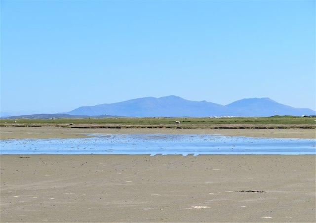
Eilean na Sròine, located in Inverness-shire, Scotland, is a small island situated in the River Ness. The island is approximately 1.7 hectares in size and is known for its picturesque beauty and historical significance.

The island is accessible by a footbridge, connecting it to the mainland, and is a popular spot for tourists and locals alike. It offers stunning panoramic views of the surrounding landscape, with its lush greenery and the flowing waters of the River Ness.

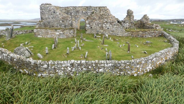
Eilean na Sròine has a rich history dating back centuries. It was once home to a Pictish fort, and remnants of it can still be seen today. The island also played a role during the Jacobite uprising, serving as a hiding place for Bonnie Prince Charlie during his escape after the Battle of Culloden in 1746.

Today, the island is a peaceful retreat where visitors can enjoy a leisurely stroll, have a picnic, or simply take in the tranquility of the surroundings. The island is known for its diverse wildlife, including various bird species, making it a haven for birdwatchers.

Eilean na Sròine is a place of natural beauty and historical significance, offering visitors a unique glimpse into Scotland's past. With its idyllic setting and rich heritage, it continues to be a cherished destination for both nature enthusiasts and history buffs.

If you have any feedback on the listing, please let us know in the comments section below.

Eilean na Sròine Images

Images are sourced within 2km of 57.533168/-7.3365801 or Grid Reference NF8061. Thanks to Geograph Open Source API. All images are credited.

Houses at Samhla
Houses at Samhla
Outside Talla Chairinis, North Uist Outside a community hall
Outside Talla Chairinis, North Uist
Outside a community hall
Blar Chairinis Site of battle in 1601.
Blar Chairinis
Site of battle in 1601.
Stone barn at Carinish
The ruins of Trinity Temple (Teampull na Trianaid) According to the plaque "Medieval monastery and college of European significance, founded by Beathag, daughter of Somhairle (Somerled).  Enlarged about 1350 to 1390 by Amie Mic Ruarie, first wife of John, Lord of the Isles.  Reconstructed in the 16th century.  Destroyed after the reformation.  Later restored in the 19th century by Dotair Ban."
The ruins of Trinity Temple (Teampull na Trianaid)
According to the plaque "Medieval monastery and college of European significance, founded by Beathag, daughter of Somhairle (Somerled). Enlarged about 1350 to 1390 by Amie Mic Ruarie, first wife of John, Lord of the Isles. Reconstructed in the 16th century. Destroyed after the reformation. Later restored in the 19th century by Dotair Ban."
Field and houses at Carinish And also the site of Feith na Fala (The ditch of blood) - a battle waged in 1601 between the MacLeods and the MacDonalds.
Field and houses at Carinish
And also the site of Feith na Fala (The ditch of blood) - a battle waged in 1601 between the MacLeods and the MacDonalds.
Bagh a’ Ghriasaiche
Bagh a’ Ghriasaiche
Fèithe na Fala - The ditch of blood
View from Temple View Hotel Teampull na Trionaid is a ruined 13th-century church and seminary at Carinish, North Uist, Scotland. Amie mac Ruari is said to have rebuilt the church in the 14th century after her divorce from John of Islay, Lord of the Isles. The ruins are protected as a scheduled monument.
View from Temple View Hotel
Teampull na Trionaid is a ruined 13th-century church and seminary at Carinish, North Uist, Scotland. Amie mac Ruari is said to have rebuilt the church in the 14th century after her divorce from John of Islay, Lord of the Isles. The ruins are protected as a scheduled monument.
Closer to the temple The ruins of Trinity Temple (Teampull na Trianaid)
Closer to the temple
The ruins of Trinity Temple (Teampull na Trianaid)
Teampull Na Trionaid A 14th century church with earlier origins. <span class="nowrap"><a title="https://canmore.org.uk/site/10265/north-uist-carinish-teampull-na-trionaid" rel="nofollow ugc noopener" href="https://canmore.org.uk/site/10265/north-uist-carinish-teampull-na-trionaid">Link</a><img style="margin-left:2px;" alt="External link" title="External link - shift click to open in new window" src="https://s1.geograph.org.uk/img/external.png" width="10" height="10"/></span>
Teampull Na Trionaid
A 14th century church with earlier origins. LinkExternal link
Teampull Na Trionaid View from the south. <span class="nowrap"><a title="https://canmore.org.uk/site/10265/north-uist-carinish-teampull-na-trionaid" rel="nofollow ugc noopener" href="https://canmore.org.uk/site/10265/north-uist-carinish-teampull-na-trionaid">Link</a><img style="margin-left:2px;" alt="External link" title="External link - shift click to open in new window" src="https://s1.geograph.org.uk/img/external.png" width="10" height="10"/></span>
Teampull Na Trionaid
View from the south. LinkExternal link
Baleshare - North Uist Causeway Looking east from Samhla to North Uist. Interestingly, although both sides are open to the sea, there is water to the south but it was dry on the north.
Baleshare - North Uist Causeway
Looking east from Samhla to North Uist. Interestingly, although both sides are open to the sea, there is water to the south but it was dry on the north.
Shore at Samhla Looking south from the west end of the causeway.
Shore at Samhla
Looking south from the west end of the causeway.
Farmhouse on Baleshare The peak in the distance, to the left, is Eaval on North Uist.
Farmhouse on Baleshare
The peak in the distance, to the left, is Eaval on North Uist.
A sandy island surrounded by sand This is the part of the extensive area of tidal sand on the east side of Baile Sear island. The sand must be firm due to the number of vehicle tyre tracks across it. Looking due east towards the profile of Eabhal.
A sandy island surrounded by sand
This is the part of the extensive area of tidal sand on the east side of Baile Sear island. The sand must be firm due to the number of vehicle tyre tracks across it. Looking due east towards the profile of Eabhal.
Vehicle graveyard Baile Sear Vehicles are rather like dwellings on the Western Isles. When no longer wanted, they are simply left to rot out in the elements.
Vehicle graveyard Baile Sear
Vehicles are rather like dwellings on the Western Isles. When no longer wanted, they are simply left to rot out in the elements.
Sand and land, Baile Sear Looking south along the beach on the east side of Baile Sear island. The view is south across the low lying Benbecula towards the big hills of South Uist.
Sand and land, Baile Sear
Looking south along the beach on the east side of Baile Sear island. The view is south across the low lying Benbecula towards the big hills of South Uist.
Show me another place!

Eilean na Sròine is located at Grid Ref: NF8061 (Lat: 57.533168, Lng: -7.3365801)

Unitary Authority: Na h-Eileanan an Iar

Police Authority: Highlands and Islands

What 3 Words

///childcare.basher.clues. Near Balivanich, Na h-Eileanan Siar

Related Wikis

Battle of Carinish

The Battle of Carinish was a Scottish clan battle fought in North Uist in 1601. It was part of a year of feuding between Clan MacLeod of Dunvegan and the...

Teampull na Trionaid

Teampull na Trionaid ("trinity church") is a ruined 13th-century Augustinian nunnery at Carinish, on North Uist, in the Outer Hebrides of Scotland. �...

Baleshare

Baleshare (Scottish Gaelic: Baile Sear) is a flat tidal island in the Outer Hebrides of Scotland. Baleshare lies to the south-west of North Uist. Its economics...

Carinish

Carinish (Scottish Gaelic: Càirinis), is a hamlet on North Uist, in the Outer Hebrides, Scotland. It is in the south of the island, about two miles (three...

Bail' Iochdrach

Bail' Iochdrach or Baliochrach (Scottish Gaelic: Am Baile Ìochdrach) is a village on Benbecula in the Outer Hebrides, Scotland. Baliochrach is within the...

Baile Glas

Baile Glas or Ballaglasa (Scottish Gaelic: Am Baile Glas) is a settlement on Grimsay in the Outer Hebrides, Scotland. Ballaglasa is within the parish of...

Kirkibost

Kirkibost (Scottish Gaelic: Eilean Chirceaboist) is a low-lying island west of North Uist in the Outer Hebrides of Scotland. == Geography == Kirkibost...

Benbecula Airport

Benbecula Airport (Scottish Gaelic: Port-adhair Bheinn na Faoghla) (IATA: BEB, ICAO: EGPL) is located on the island of Benbecula in the Outer Hebrides...

Have you been to Eilean na Sròine?

Leave your review of Eilean na Sròine below (or comments, questions and feedback).