Corrie of Laidwinley
Corrie (Glacial Valley) in Angus
Scotland
Corrie of Laidwinley

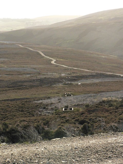
Corrie of Laidwinley, located in Angus, Scotland, is a picturesque glacial valley known for its stunning natural beauty and unique geological features. Also known as Corrie, this small valley is nestled within the eastern edge of the Cairngorms National Park, offering visitors a serene and tranquil environment.
The area is characterized by its U-shaped valley, which is a distinctive feature resulting from glacial erosion during the last Ice Age. The valley is surrounded by steep, rugged slopes, with the highest point being Mount Laidwinley, reaching an elevation of approximately 900 meters (2,953 feet). The slopes are covered in a diverse range of vegetation, including heather, grasses, and scattered birch trees, adding to the scenic appeal of the area.
Corrie of Laidwinley is home to a variety of wildlife, including red deer, mountain hares, and various bird species such as ptarmigans and golden eagles. The valley is also known for its crystal-clear streams and small waterfalls, which add to the overall charm and tranquility of the landscape.
Outdoor enthusiasts can explore Corrie by following a network of well-defined hiking trails that offer breathtaking views of the valley and surrounding peaks. The area is particularly popular among hikers, climbers, and nature lovers seeking an escape from the hustle and bustle of urban life.
Overall, Corrie of Laidwinley is a hidden gem within Angus, offering a unique and awe-inspiring natural environment for those seeking a peaceful retreat or a thrilling outdoor adventure.
If you have any feedback on the listing, please let us know in the comments section below.
Corrie of Laidwinley Images
Images are sourced within 2km of 56.803658/-2.8527629 or Grid Reference NO4868. Thanks to Geograph Open Source API. All images are credited.


Corrie of Laidwinley is located at Grid Ref: NO4868 (Lat: 56.803658, Lng: -2.8527629)
Unitary Authority: Angus
Police Authority: Tayside
What 3 Words
///wreck.grumbles.machinery. Near Brechin, Angus
Nearby Locations
Related Wikis

Angus (UK Parliament constituency)
Angus is a county constituency of the House of Commons of the Parliament of the United Kingdom (at Westminster). It elects one Member of Parliament (MP...

Auchnacree
Auchnacree is an estate in Angus, Scotland, five miles north of Forfar.In 1921 the estate overseer, Mr Frank Rae, discovered what is now called the Auchnacree...
Five Glens of Angus
The Five Glens of Angus are the five Highland glens located in the western portion of the Angus region of Scotland. The five glens from westernmost to...

Menmuir
Menmuir is a parish in the county of Angus in Scotland. Kirkton of Menmuir consists of only three houses (the Old Schoolhouse, the Manse, the Old Inn)...

Caterthun
Caterthun, or the Caterthuns, is a ridge of hills near the city of Brechin in Angus, Scotland. The Caterthuns are notable for being the site of two Iron...

Noranside
Noranside is a hamlet in Angus, Scotland, located at 56° 44' 0" North, 2° 52' 0" West,. The prison HMP Noranside was operated there from 1966 to 2011....

Careston railway station
Careston railway station served the hamlet of Careston, Angus, Scotland, from 1895 to 1964 on the Forfar and Brechin Railway. == History == The station...
Careston
Careston is a hamlet in Angus, Scotland that is in the parish of the same name, 5 miles west of Brechin. The parish and hamlet supposedly took their name...
Have you been to Corrie of Laidwinley?
Leave your review of Corrie of Laidwinley below (or comments, questions and feedback).