Coire na Cloiche

Corrie (Glacial Valley) in Angus

Scotland

Coire na Cloiche

Corwharn cairn A neatly built cairn on a stoney ridge just a few metres from the 611 metre (2005 feet) high summit of Corwharn. About two metres tall, it is generally known as a 'stone man'. What looks at first like another 'stone man' on the background hill left of centre is actually a much larger edifice, the Airlie Tower monument <a href="https://www.geograph.org.uk/gridref/NO3761">NO3761</a>.
Corwharn cairn Credit: James Allan

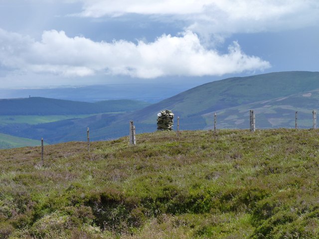
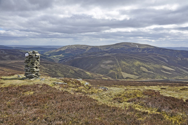
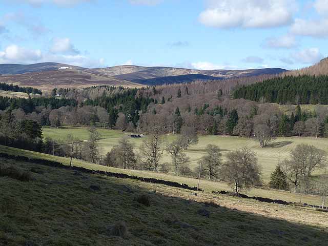
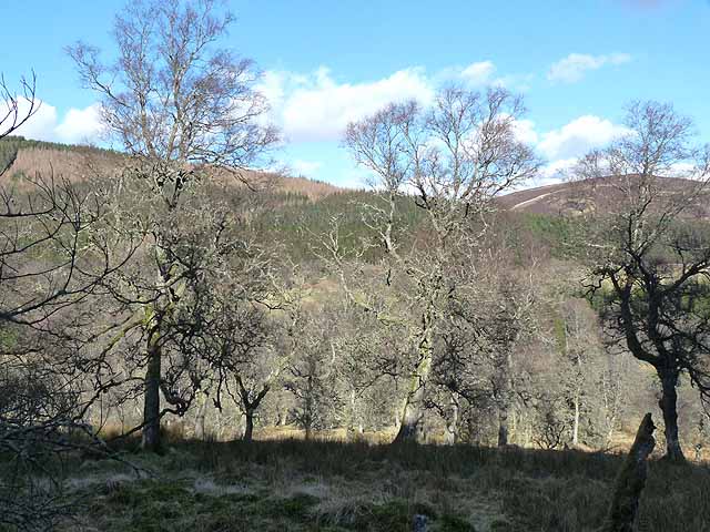
Coire na Cloiche, also known as Corrie, is a stunning glacial valley located in the Angus region of Scotland. Surrounded by towering mountains and characterized by its steep sides and U-shaped formation, this natural wonder offers breathtaking views and a serene atmosphere.

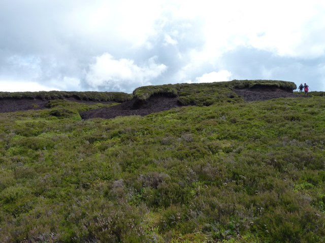
Situated within the Cairngorms National Park, Coire na Cloiche is a testament to the region's glacial past. The valley was formed thousands of years ago during the last ice age when powerful glaciers carved out the landscape, leaving behind this magnificent geological feature. The valley floor is covered in lush grasses and dotted with small streams, adding to its picturesque charm.

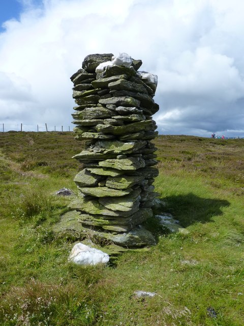
Coire na Cloiche is a popular destination for hikers and nature enthusiasts. Its remote location and rugged terrain make it an ideal spot for those seeking a challenging adventure. The valley provides numerous hiking trails, allowing visitors to explore its beauty and experience the tranquility of the surrounding wilderness.

Wildlife enthusiasts will also find Coire na Cloiche to be a haven for various species. The valley is home to a diverse range of flora and fauna, including mountain hares, red deer, and a variety of bird species. Birdwatchers can spot golden eagles soaring above the mountains, while botany enthusiasts can marvel at the colorful wildflowers that bloom in the summer months.

Whether you are an avid hiker, a nature lover, or simply seeking a peaceful retreat, Coire na Cloiche is a place of natural beauty that is not to be missed. Its awe-inspiring landscapes and rich biodiversity make it a must-visit destination for anyone exploring the Angus region of Scotland.

If you have any feedback on the listing, please let us know in the comments section below.

Coire na Cloiche Images

Images are sourced within 2km of 56.771776/-3.1334325 or Grid Reference NO3065. Thanks to Geograph Open Source API. All images are credited.

Corwharn cairn A neatly built cairn on a stoney ridge just a few metres from the 611 metre (2005 feet) high summit of Corwharn. About two metres tall, it is generally known as a 'stone man'. What looks at first like another 'stone man' on the background hill left of centre is actually a much larger edifice, the Airlie Tower monument <a href="https://www.geograph.org.uk/gridref/NO3761">NO3761</a>.
Corwharn cairn
A neatly built cairn on a stoney ridge just a few metres from the 611 metre (2005 feet) high summit of Corwharn. About two metres tall, it is generally known as a 'stone man'. What looks at first like another 'stone man' on the background hill left of centre is actually a much larger edifice, the Airlie Tower monument NO3761.
Peat haggs The figures alongside them give some impression of the size of these peat haggs near the summit of Corwharn.
Peat haggs
The figures alongside them give some impression of the size of these peat haggs near the summit of Corwharn.
Enigmatic 'stone man' on Corwharn A carefully crafted square section dry-stone cairn about two metres tall near the 2005 feet summit of Corwharn. Its builder, obviously a dab hand at dry-stane dyking, seems to have used local slatey stone and quartz in its construction, but who built the so-called 'stone man', when and for what purpose seems to be shrouded in mystery.
Enigmatic 'stone man' on Corwharn
A carefully crafted square section dry-stone cairn about two metres tall near the 2005 feet summit of Corwharn. Its builder, obviously a dab hand at dry-stane dyking, seems to have used local slatey stone and quartz in its construction, but who built the so-called 'stone man', when and for what purpose seems to be shrouded in mystery.
Cairn on Corwharn Glen Uig below and Cat Law beyond
Cairn on Corwharn
Glen Uig below and Cat Law beyond
Peat haggs Near the summit of Corwharn.
Peat haggs
Near the summit of Corwharn.
Glen Uig, Braes of Angus The overgrown sheep fank to the left of the picture shows how grouse moors have replaced sheep runs in this part of the Grampians.
Glen Uig, Braes of Angus
The overgrown sheep fank to the left of the picture shows how grouse moors have replaced sheep runs in this part of the Grampians.
Glen Prosen at Cormuir The most prominent peak on the skyline is Driesh <a href="https://www.geograph.org.uk/gridref/NO2773">NO2773</a>, still with patches of snow even on south-facing slopes.
Glen Prosen at Cormuir
The most prominent peak on the skyline is Driesh NO2773, still with patches of snow even on south-facing slopes.
Glen Prosen - the path to Glen Markie and Glen Isla One of a chain of signposted paths linking the Glens of Angus.
Glen Prosen - the path to Glen Markie and Glen Isla
One of a chain of signposted paths linking the Glens of Angus.
Glen Prosen at Balnaboth Balnaboth is hidden in the trees on the far side of the valley. There are still patches of snow on the mountains at the head of the Glen, even on the south-facing slopes.
Glen Prosen at Balnaboth
Balnaboth is hidden in the trees on the far side of the valley. There are still patches of snow on the mountains at the head of the Glen, even on the south-facing slopes.
Woodland near Dalairn The wooded slopes of Blanaboth Craig can be seen on the far side of the valley.
Woodland near Dalairn
The wooded slopes of Blanaboth Craig can be seen on the far side of the valley.
Prosen Water Near Cormuir.
Typical 'glen weather'.
Prosen Water
Near Cormuir. Typical 'glen weather'.
Dalairn Cottage beside Prosen Water.
Dalairn
Cottage beside Prosen Water.
Sheep near Cormuir Sheep scattered around a field of buttercups near Cormuir in Glen Prosen.
Sheep near Cormuir
Sheep scattered around a field of buttercups near Cormuir in Glen Prosen.
Wooded road in Glen Prosen The road heading up Glen Prosen through a section of wooded hillside.
Wooded road in Glen Prosen
The road heading up Glen Prosen through a section of wooded hillside.
Glen Prosen woodland Woodland next to the Glen Prosen road near Dalairn.
Glen Prosen woodland
Woodland next to the Glen Prosen road near Dalairn.
The head of Glen Uig. Below Corwharn, the Glen Uig side of the pass between Glen Uig and Glen Quharity.  Downstream the glen deepens and narrows.
The head of Glen Uig.
Below Corwharn, the Glen Uig side of the pass between Glen Uig and Glen Quharity. Downstream the glen deepens and narrows.
Heather moor There are no named features within this square. This picture is taken just beyond the fence above a valley that contains an unnamed tributary of the Burn of Cormuir.
Heather moor
There are no named features within this square. This picture is taken just beyond the fence above a valley that contains an unnamed tributary of the Burn of Cormuir.
Footpath in Glen Uig The sign indicates it is 1.9 miles to Glenuig, 3.2 miles to Easter Lednathie, 2.1 miles to Longdrum or 3.7 miles to Balintore.  This is grouse country and the ground is managed for the shooting with many larsen traps in the surrounding area.
Footpath in Glen Uig
The sign indicates it is 1.9 miles to Glenuig, 3.2 miles to Easter Lednathie, 2.1 miles to Longdrum or 3.7 miles to Balintore. This is grouse country and the ground is managed for the shooting with many larsen traps in the surrounding area.
Show me another place!

Coire na Cloiche is located at Grid Ref: NO3065 (Lat: 56.771776, Lng: -3.1334325)

Unitary Authority: Angus

Police Authority: Tayside

What 3 Words

///fuzz.grow.gliders. Near Kirriemuir, Angus

Related Wikis

Cat Law

Cat Law (671 m) is a hill in the southern Mounth of Scotland, north of Kirriemuir in Angus. A rounded peak, it lies above Strathmore in the south and offers...

Balintore Castle

Balintore Castle is a Victorian Category A listed building in Scotland. The castle occupies an elevated site in moorland above Balintore village, a few...

Balintore, Angus

Balintore (Scottish Gaelic: Baile an Todhair) is a village in Angus, Scotland. It lies in Glen Isla, four miles north of the Loch of Lintrathen and seven...

Mile Hill, Dykehead

There is another Mile Hill nearby which is a MarilynMile Hill is located in Angus, Scotland, 1000 metres west of Dykehead. It is a circular hill rising...

Ascreavie

Ascreavie is a country house in Angus, Scotland. It is located 2 kilometres (1.2 mi) north of Kirkton of Kingoldrum, and 6 kilometres (3.7 mi) north-west...

Clova, Angus

Clova is a village in Glen Clova, Angus, Scotland. It lies on the River South Esk, some 12 miles (19 km) north of Kirriemuir. During the 1745 Jacobite...

Backwater Reservoir

Backwater Reservoir is a reservoir in north west Angus, Scotland. The reservoir's sole purpose is to provide drinking water, and as such, it supplies Angus...

Knockshannoch Lodge

Knockshannoch Lodge is a Category B listed building in the Scottish village of Glenisla, Angus, built around 1888. It is a small, single-storey cottage...

Nearby Amenities

Located within 500m of 56.771776,-3.1334325
Hill of Adenaich
Ele: 553
Natural: peak
Lat/Long: 56.7734998/-3.1405894
Coire na Cloiche
Natural: valley
Valley: cirque
Lat/Long: 56.7719729/-3.1340976
The data included in this document is from www.openstreetmap.org. The data is made available under ODbL.

Have you been to Coire na Cloiche?

Leave your review of Coire na Cloiche below (or comments, questions and feedback).