Corrie of Farchal

Corrie (Glacial Valley) in Angus

Scotland

Corrie of Farchal

Ruined dwelling at Bontyre, Glen Clova See also <a href="https://www.geograph.org.uk/photo/472227">NO3074 : Ruin, Glen Clova.</a> The ruins may have been a shepherd's home as nearby there remains evidence of a fairly large fank.
Ruined dwelling at Bontyre, Glen Clova Credit: Douglas Nelson

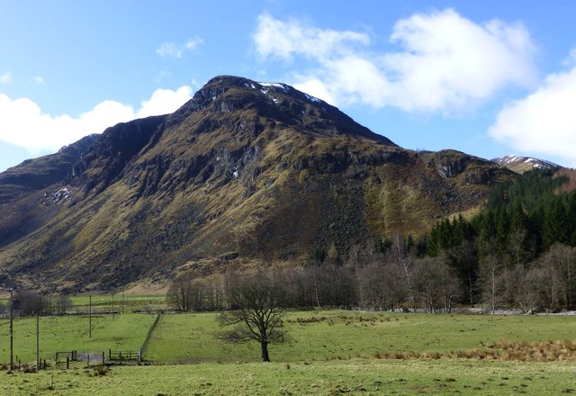
Corrie of Farchal is a glacial valley located in the Angus region of Scotland. Nestled within the stunning landscapes of the Cairngorms National Park, it is a popular destination for outdoor enthusiasts and nature lovers alike.

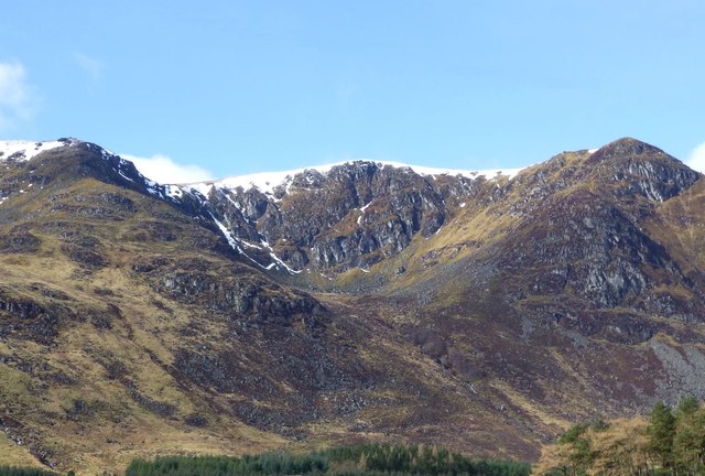
The corrie, also known as a cirque or a cwm, was formed during the last ice age as a result of glacial erosion. Its distinct U-shaped valley is surrounded by steep cliffs and is typically found at the head of a mountain. Corrie of Farchal is no exception, with its dramatic and rugged terrain making it a visually captivating location.

The valley is characterized by its picturesque beauty, boasting breathtaking views of the surrounding mountains and the crystal-clear waters of the Farchal Burn that flow through it. The vegetation in the area is diverse, with heather, grasses, and mosses covering the lower slopes, while hardier alpine plants can be found higher up.

Hiking and mountaineering are popular activities in Corrie of Farchal, with several trails offering different levels of difficulty. The corrie is also home to a variety of wildlife, including red deer, mountain hares, and golden eagles, making it a haven for wildlife enthusiasts and birdwatchers.

Overall, Corrie of Farchal is a remarkable natural feature, showcasing the geological wonders and biodiversity of the Scottish Highlands. Its scenic beauty and accessibility make it an ideal destination for those seeking to immerse themselves in the splendor of this glacial valley.

If you have any feedback on the listing, please let us know in the comments section below.

Corrie of Farchal Images

Images are sourced within 2km of 56.851104/-3.1763962 or Grid Reference NO2873. Thanks to Geograph Open Source API. All images are credited.

Ruined dwelling at Bontyre, Glen Clova See also <a href="https://www.geograph.org.uk/photo/472227">NO3074 : Ruin, Glen Clova.</a> The ruins may have been a shepherd's home as nearby there remains evidence of a fairly large fank.
Ruined dwelling at Bontyre, Glen Clova
See also NO3074 : Ruin, Glen Clova. The ruins may have been a shepherd's home as nearby there remains evidence of a fairly large fank.
Remains of fank, Glen Clova The outline of stones indicate the possibility of a fairly large fank being in existence. Nearby there are the ruins of a dwelling. See <a href="https://www.geograph.org.uk/photo/5466583">NO3074 : Ruined dwelling at Bontyre, Glen Clova</a>
Remains of fank, Glen Clova
The outline of stones indicate the possibility of a fairly large fank being in existence. Nearby there are the ruins of a dwelling. See NO3074 : Ruined dwelling at Bontyre, Glen Clova
Trig and cairn on Driesh
Approaching summit of Driesh Flat summit area crowned by a stone shelter and trig pillar.
Approaching summit of Driesh
Flat summit area crowned by a stone shelter and trig pillar.
Corrie Kilbo from the bottom The two patches of woodland provide good protection for a large herd of deer.
Corrie Kilbo from the bottom
The two patches of woodland provide good protection for a large herd of deer.
Summit of Driesh 947m A Munro defined as a mountain in Scotland with a height over 3,000 feet (914.4 m), and which is on the Scottish Mountaineering Club (SMC) official list of Munros; there is no explicit topographical prominence requirement.
Summit of Driesh 947m
A Munro defined as a mountain in Scotland with a height over 3,000 feet (914.4 m), and which is on the Scottish Mountaineering Club (SMC) official list of Munros; there is no explicit topographical prominence requirement.
The Scorrie Viewed from Acharn.
The Shank of Drumfollow just visible on the right.
The Scorrie
Viewed from Acharn. The Shank of Drumfollow just visible on the right.
Winter Corrie, Glen Clova With a little snow in the gullies and remnants of cornices.
Winter Corrie, Glen Clova
With a little snow in the gullies and remnants of cornices.
Red Craig The rocky lower slopes.
Red Craig
The rocky lower slopes.
The Scorrie
The Scorrie
Driesh summit towards Glen Doll Forest
Field, Glen Clova Looking towards Driesh and the Winter Corrie.
Field, Glen Clova
Looking towards Driesh and the Winter Corrie.
Road up Glen Clova At the head of the glen on a February morning.
Road up Glen Clova
At the head of the glen on a February morning.
Driesh and Little Driesh Driesh is slightly behind the foreground ridge of Little Driesh but is actually the higher summit.
Driesh and Little Driesh
Driesh is slightly behind the foreground ridge of Little Driesh but is actually the higher summit.
Driesh Trig Point The enclosure gives a welcome shelter from the chill winds while having your lunch.
Driesh Trig Point
The enclosure gives a welcome shelter from the chill winds while having your lunch.
Burn of Kilbo The Kilbo Path crosses the burn of the same name here.
Burn of Kilbo
The Kilbo Path crosses the burn of the same name here.
Shank of Driesh track The track heading northwards up the Shank of Driesh.
Shank of Driesh track
The track heading northwards up the Shank of Driesh.
Summit of Driesh Looking south-westwards to the trig pillar and stone shelter on the summit of Driesh.
Summit of Driesh
Looking south-westwards to the trig pillar and stone shelter on the summit of Driesh.
Show me another place!

Corrie of Farchal is located at Grid Ref: NO2873 (Lat: 56.851104, Lng: -3.1763962)

Unitary Authority: Angus

Police Authority: Tayside

What 3 Words

///shaves.dialects.icebergs. Near Kirriemuir, Angus

Nearby Locations

Corrie of Farchal

Related Wikis

Driesh

Driesh (Gaelic: Dris) is a mountain located in the Grampians of Scotland. Apart from Mount Keen (939 m/3,080 ft), it is the most easterly of the Munro...

Glen Doll

Glen Doll, also sometimes spelt Glendoll, lies within the Cairngorms National Park, Scotland, at the top of Glen Clova, in an area of steep hills, corries...

Corrie Fee

Corrie Fee is a glacier-carved corrie situated at the head of Glen Clova in the Angus Glens of Scotland. It forms part of Corrie Fee National Nature Reserve...

Mayar (mountain)

Mayar is a mountain in the Grampians, in Angus, Scotland. It is usually climbed together with its near neighbour, Driesh. At an elevation of 928 m, it...

Clova, Angus

Clova is a village in Glen Clova, Angus, Scotland. It lies on the River South Esk, some 12 miles (19 km) north of Kirriemuir. During the 1745 Jacobite...

Caenlochan

Caenlochan (Scottish Gaelic: Cadha an Lochain) is a glen in the Grampian Mountains of Scotland. Under EU Natura 2000 legislation it is a Special Area of...

Glas-allt-Shiel

Glas-allt-Shiel is a lodge on the Balmoral Estate by the shore of Loch Muick in Aberdeenshire, Scotland. In its present form it was built in 1868 by Queen...

Broad Cairn

Broad Cairn is a mountain in the Grampians of Scotland, located about sixteen miles south of the River Dee near Balmoral.

Nearby Amenities

Located within 500m of 56.851104,-3.1763962
Sneck of Farchal
Natural: saddle
Lat/Long: 56.8479849/-3.1785005
Corrie of Farchal
Natural: cirque
Lat/Long: 56.8534293/-3.1762045
The data included in this document is from www.openstreetmap.org. The data is made available under ODbL.

Have you been to Corrie of Farchal?

Leave your review of Corrie of Farchal below (or comments, questions and feedback).