Coire Breabaig

Corrie (Glacial Valley) in Banffshire

Scotland

Coire Breabaig

Island on the Avon
Island on the Avon Credit: Mike Dunn

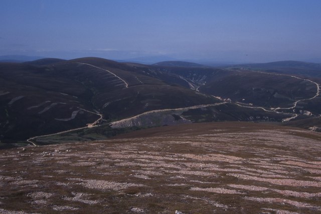
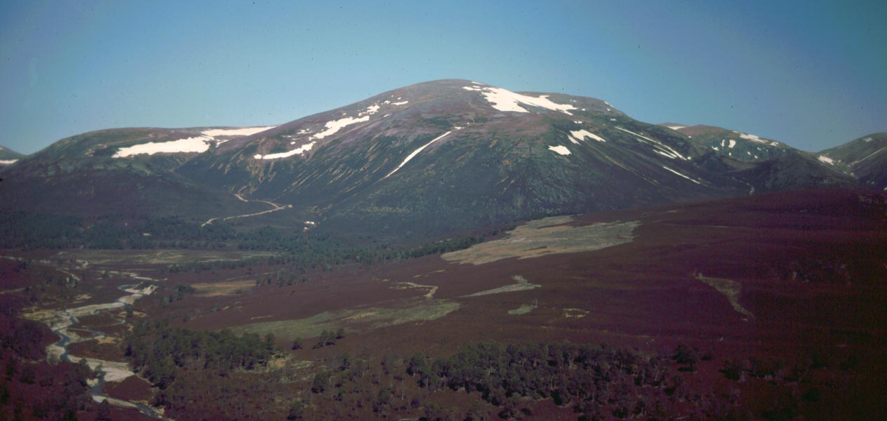
Coire Breabaig is a stunning glacial valley located in Banffshire, Scotland. Nestled within the Cairngorms National Park, this picturesque corrie (a bowl-shaped hollow) is a popular destination for hikers and nature enthusiasts alike.

The corrie is situated at an elevation of approximately 800 meters, surrounded by towering mountains and rugged cliffs. Its formation can be attributed to the powerful glacial activity during the last Ice Age, which carved out this remarkable landscape. As a result, Coire Breabaig boasts steep, rocky slopes and a deep basin, providing a dramatic and awe-inspiring sight for visitors.

The valley is characterized by its diverse and lush vegetation, with various species of heather, moss, and wildflowers dotting the landscape. The area is also home to a wide array of wildlife, including red deer, mountain hares, and golden eagles, making it a haven for nature lovers and wildlife enthusiasts.

Hiking is a popular activity in Coire Breabaig, with several trails available for exploration. These trails offer stunning panoramic views of the surrounding mountains and valleys, as well as opportunities to spot the local wildlife. Additionally, the corrie serves as a starting point for more challenging hikes, such as ascending the nearby Munros (mountains over 3,000 feet).

Coire Breabaig is a place of natural beauty and tranquility, offering visitors a chance to immerse themselves in the breathtaking scenery of the Scottish Highlands. With its rich geological history, diverse flora and fauna, and numerous hiking opportunities, this glacial valley is a must-visit destination for anyone seeking an unforgettable outdoor experience.

If you have any feedback on the listing, please let us know in the comments section below.

Coire Breabaig Images

Images are sourced within 2km of 57.130106/-3.4269765 or Grid Reference NJ1305. Thanks to Geograph Open Source API. All images are credited.

Island on the Avon
Island on the Avon
Looking west up Glen Avon
The burn between Da Dhruim Lom and Clach Fiaraidh
Ford, Allt nam Broighleag On an estate track which goes up Glen Avon to Faindouran.
Ford, Allt nam Broighleag
On an estate track which goes up Glen Avon to Faindouran.
Track in Glen Avon An estate track going up Glen Avon towards Faindouran.  Looking towards Beinn A' Bhuird.
Track in Glen Avon
An estate track going up Glen Avon towards Faindouran. Looking towards Beinn A' Bhuird.
River Avon north of The Bruach With Ben Avon in the distance.
River Avon north of The Bruach
With Ben Avon in the distance.
The Ponymen's Hut, Glen Avon A dilapidated shelter beside the River Avon.
The Ponymen's Hut, Glen Avon
A dilapidated shelter beside the River Avon.
Footbridge over the River Avon at the Ponymen's Hut A suspension bridge on a path towards Beinn A' Bhuird.
Footbridge over the River Avon at the Ponymen's Hut
A suspension bridge on a path towards Beinn A' Bhuird.
View North from West Muir Gorm Craig Looking down into Glen Avon.
View North from West Muir Gorm Craig
Looking down into Glen Avon.
View West from East Muir Gorm Craig
Summit of Stob Bac an Fhurain
Moraine deposits in Glen Avon. Track down Glen Avon with glacial deposits visible beneath Ben Avon. Some of the Ben Avon tors can also be seen.
Moraine deposits in Glen Avon.
Track down Glen Avon with glacial deposits visible beneath Ben Avon. Some of the Ben Avon tors can also be seen.
Granite outcrop on Ben Avon This is much bigger than it appears - 25 metres high, with several others situated on the ridge above and below. It is similar to the tors on the summit plateau. These outcrops occur at approximately Munro height.
Granite outcrop on Ben Avon
This is much bigger than it appears - 25 metres high, with several others situated on the ridge above and below. It is similar to the tors on the summit plateau. These outcrops occur at approximately Munro height.
Footbridge over the River Avon
Bridge over River Avon Wobbly bridge only suitable for pedestrians. Track and shed position slightly different to that shown on OS Map at time.
Bridge over River Avon
Wobbly bridge only suitable for pedestrians. Track and shed position slightly different to that shown on OS Map at time.
Caol Ghleann, Ben Avon Taken on the descent of the ridge to the west of Lochan nan Gabhar, Ben Avon.
Caol Ghleann, Ben Avon
Taken on the descent of the ridge to the west of Lochan nan Gabhar, Ben Avon.
Lochan nan Gabhar, Ben Avon The beautiful Lochan nan Gabhar (Goats' Lochan) on Ben Avon.
Lochan nan Gabhar, Ben Avon
The beautiful Lochan nan Gabhar (Goats' Lochan) on Ben Avon.
North slope of Da Dhruim Lom Looking across Glen Avon towards Big Garvoun and Glen Loin, badly scarred by landrover tracks
North slope of Da Dhruim Lom
Looking across Glen Avon towards Big Garvoun and Glen Loin, badly scarred by landrover tracks
Show me another place!

Coire Breabaig is located at Grid Ref: NJ1305 (Lat: 57.130106, Lng: -3.4269765)

Unitary Authority: Moray

Police Authority: North East

What 3 Words

///overlooks.cowering.cross. Near Inverey, Aberdeenshire

Nearby Locations

Coire Breabaig

Related Wikis

Ben Avon

Ben Avon (Scottish Gaelic: Beinn Athfhinn, 'mountain of the Avon') is a mountain in the Cairngorms of Scotland. It is a sprawling mountain with a broad...

Beinn a' Bhùird

Beinn a' Bhùird is a Munro in the Cairngorm mountain range of Scotland. In Watson (1975) the author suggests the mountain should be named Beinn Bòrd -...

Culardoch

Culardoch (900 m) is a mountain in the Cairngorms of Scotland, located northeast of Braemar in Aberdeenshire. A smooth and heathery peak southeast of the...

Delnadamph Lodge

Delnadamph Lodge was located on the Balmoral Estate about 8 miles (13 km) north of the castle. The lodge and its estate lands were bought by Queen Elizabeth...

Nearby Amenities

Located within 500m of 57.130106,-3.4269765
Da Dhruim Lom
Ele: 805
Place: locality
Lat/Long: 57.1278901/-3.4205838
Coire Breabaig
Place: locality
Lat/Long: 57.1299744/-3.4288931
The data included in this document is from www.openstreetmap.org. The data is made available under ODbL.

Have you been to Coire Breabaig?

Leave your review of Coire Breabaig below (or comments, questions and feedback).