Coire Odhar

Corrie (Glacial Valley) in Banffshire

Scotland

Coire Odhar

The burn between Da Dhruim Lom and Clach Fiaraidh
The burn between Da Dhruim Lom and Clach Fiaraidh Credit: Mike Dunn

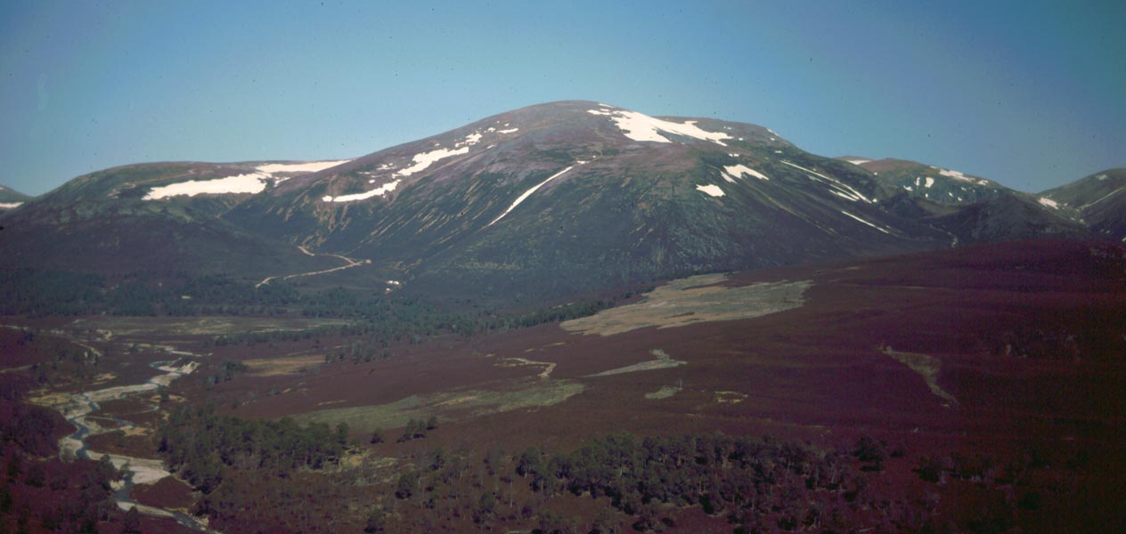
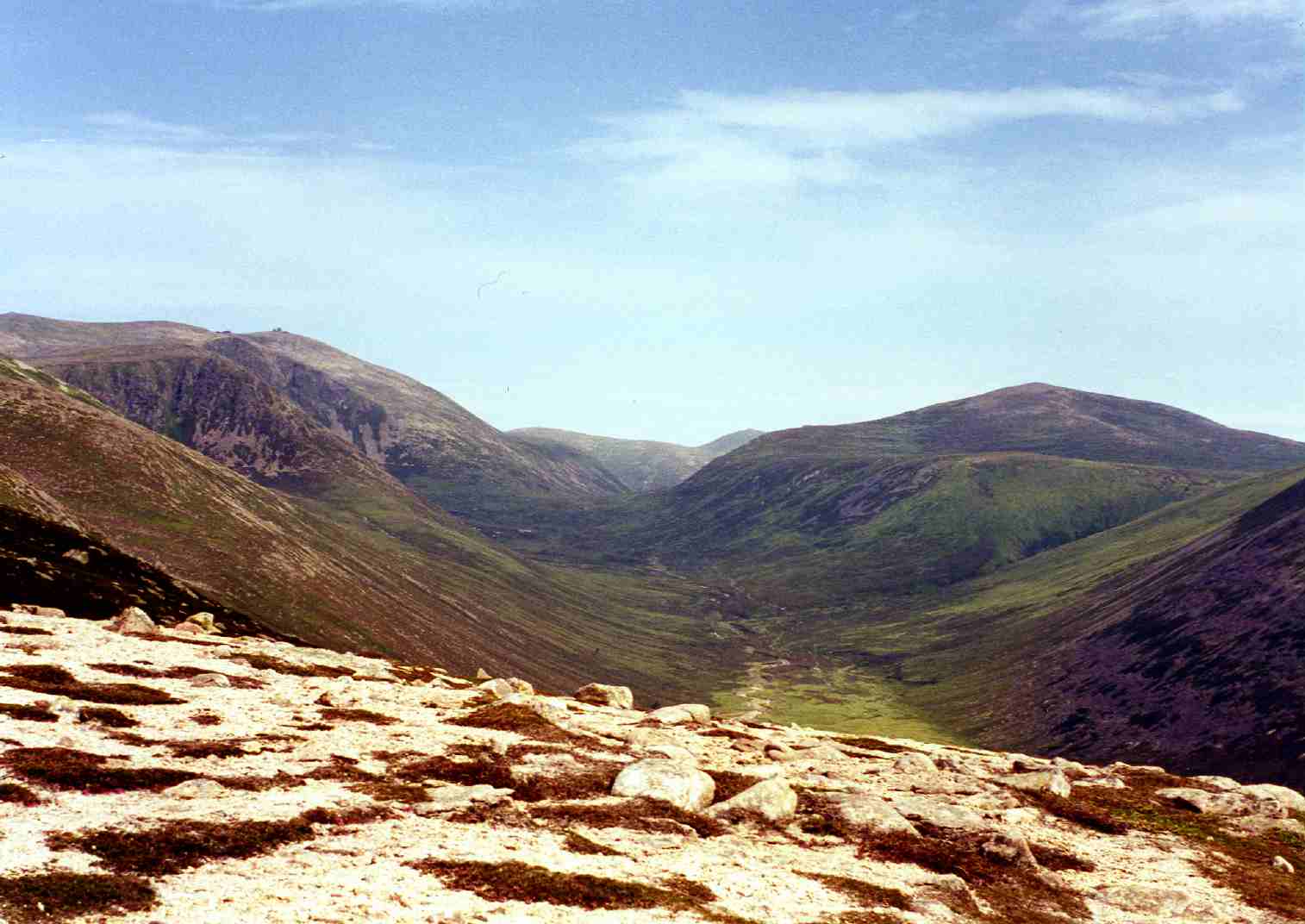
Coire Odhar, also known as Corrie, is a glacial valley located in Banffshire, Scotland. Situated in the Cairngorms National Park, it is renowned for its breathtaking natural beauty and unique geological features.

The valley is characterized by steep, U-shaped sides that were carved out by glacial activity during the last ice age. These glaciers slowly eroded the landscape, leaving behind a deep and narrow valley with towering cliffs on either side. Coire Odhar is nestled amidst the majestic Cairngorm Mountains, offering visitors stunning panoramic views of the surrounding peaks and valleys.

The valley is home to a diverse range of flora and fauna, owing to its sheltered location and varied microclimates. Visitors may encounter mountain hares, ptarmigans, and red deer while exploring the area. Additionally, the valley is adorned with vibrant heather and wildflowers during the summer months, painting the landscape with an array of colors.

Coire Odhar is a popular destination for outdoor enthusiasts, offering a range of activities such as hiking, mountaineering, and wildlife spotting. There are several well-marked trails that lead visitors through the valley, providing opportunities to explore its hidden corners and discover its natural wonders.

The area surrounding Coire Odhar is also rich in cultural heritage, with several historic sites nearby, including ancient cairns and standing stones. The valley has been a source of inspiration for artists and writers over the centuries, with its dramatic scenery often depicted in various forms of art.

Overall, Coire Odhar is a captivating glacial valley that captivates visitors with its awe-inspiring beauty and abundant natural wonders.

If you have any feedback on the listing, please let us know in the comments section below.

Coire Odhar Images

Images are sourced within 2km of 57.12208/-3.4296573 or Grid Reference NJ1304. Thanks to Geograph Open Source API. All images are credited.

The burn between Da Dhruim Lom and Clach Fiaraidh
Outflow from Lochan nan Gabhar The only corrie lochan on Ben Avon
Outflow from Lochan nan Gabhar
The only corrie lochan on Ben Avon
Track in Glen Avon An estate track going up Glen Avon towards Faindouran.  Looking towards Beinn A' Bhuird.
Track in Glen Avon
An estate track going up Glen Avon towards Faindouran. Looking towards Beinn A' Bhuird.
The Ponymen's Hut, Glen Avon A dilapidated shelter beside the River Avon.
The Ponymen's Hut, Glen Avon
A dilapidated shelter beside the River Avon.
Footbridge over the River Avon at the Ponymen's Hut A suspension bridge on a path towards Beinn A' Bhuird.
Footbridge over the River Avon at the Ponymen's Hut
A suspension bridge on a path towards Beinn A' Bhuird.
View ENE from the summit of Ben Avon showing plateau & granite tors
Rocky Tor on Ben Avon There are many of these rocky tors scattered around the Ben Avon plateau.
Rocky Tor on Ben Avon
There are many of these rocky tors scattered around the Ben Avon plateau.
Rock Basins There are numerous almost perfectly circular, bowl shaped holes in the rocks on Ben Avon plateau. Glacial stone masons at work?
Rock Basins
There are numerous almost perfectly circular, bowl shaped holes in the rocks on Ben Avon plateau. Glacial stone masons at work?
Stob Bac an Fhurain Seen from the Ben Avon plateau.
Stob Bac an Fhurain
Seen from the Ben Avon plateau.
View North-East over the broad shoulder of Mullach Lochan nan Gabhar
Hills Above Lochan nan Gabhar Seen from the North-East end of the Ben Avon plateau. The hill on the right is West Meur Gorm Craig.
Hills Above Lochan nan Gabhar
Seen from the North-East end of the Ben Avon plateau. The hill on the right is West Meur Gorm Craig.
View North from West Muir Gorm Craig Looking down into Glen Avon.
View North from West Muir Gorm Craig
Looking down into Glen Avon.
View West from East Muir Gorm Craig
Summit of Stob Bac an Fhurain
Moraine deposits in Glen Avon. Track down Glen Avon with glacial deposits visible beneath Ben Avon. Some of the Ben Avon tors can also be seen.
Moraine deposits in Glen Avon.
Track down Glen Avon with glacial deposits visible beneath Ben Avon. Some of the Ben Avon tors can also be seen.
Granite outcrop on Ben Avon This is much bigger than it appears - 25 metres high, with several others situated on the ridge above and below. It is similar to the tors on the summit plateau. These outcrops occur at approximately Munro height.
Granite outcrop on Ben Avon
This is much bigger than it appears - 25 metres high, with several others situated on the ridge above and below. It is similar to the tors on the summit plateau. These outcrops occur at approximately Munro height.
Footbridge over the River Avon
Bridge over River Avon Wobbly bridge only suitable for pedestrians. Track and shed position slightly different to that shown on OS Map at time.
Bridge over River Avon
Wobbly bridge only suitable for pedestrians. Track and shed position slightly different to that shown on OS Map at time.
Show me another place!

Coire Odhar is located at Grid Ref: NJ1304 (Lat: 57.12208, Lng: -3.4296573)

Unitary Authority: Moray

Police Authority: North East

What 3 Words

///yesterday.besotted.zoned. Near Inverey, Aberdeenshire

Nearby Locations

Coire Odhar

Related Wikis

Ben Avon

Ben Avon (Scottish Gaelic: Beinn Athfhinn, 'mountain of the Avon') is a mountain in the Cairngorms of Scotland. It is a sprawling mountain with a broad...

Beinn a' Bhùird

Beinn a' Bhùird is a Munro in the Cairngorm mountain range of Scotland. In Watson (1975) the author suggests the mountain should be named Beinn Bòrd -...

Culardoch

Culardoch (900 m) is a mountain in the Cairngorms of Scotland, located northeast of Braemar in Aberdeenshire. A smooth and heathery peak southeast of the...

Beinn a' Chaorainn (Cairngorms)

Beinn a' Chaorainn is a Scottish mountain in the heart of the Cairngorms range. It is quite a remote hill, being located roughly 19 kilometres south east...

Bynack More

Bynack More (Scottish Gaelic: A' Bheithneag Mhòr or Beinn Bheithneag) is a Scottish Mountain that is situated in the Cairngorms range, 16 kilometres east...

Delnadamph Lodge

Delnadamph Lodge was located on the Balmoral Estate about 8 miles (13 km) north of the castle. The lodge and its estate lands were bought by Queen Elizabeth...

Nearby Amenities

Located within 500m of 57.12208,-3.4296573
Coire Odhar
Place: locality
Lat/Long: 57.120773/-3.4270799
The data included in this document is from www.openstreetmap.org. The data is made available under ODbL.

Have you been to Coire Odhar?

Leave your review of Coire Odhar below (or comments, questions and feedback).