Coire Raibeirt

Corrie (Glacial Valley) in Banffshire

Scotland

Coire Raibeirt

Path towards Coire Raibeirt
Path towards Coire Raibeirt Credit: Steven Brown

The requested URL returned error: 429 Too Many Requests

If you have any feedback on the listing, please let us know in the comments section below.

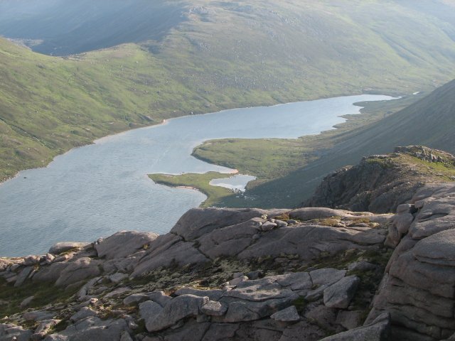
Coire Raibeirt Images

Images are sourced within 2km of 57.107722/-3.6464572 or Grid Reference NJ0003. Thanks to Geograph Open Source API. All images are credited.

Path towards Coire Raibeirt
Path in Coire Raibeirt
Allt Coire Raibeirt
Allt Coire Raibeirt
Beach on Loch Avon
Beach on Loch Avon
Head of Loch Avon
Head of Loch Avon
Wind-blown snow, Cairn Gorm A little dry snow on the NE side of the summit plateau being picked up by vortices in a strong (50 - 60 mph) W wind. More localised examples are sometimes referred to as snow devils.
Wind-blown snow, Cairn Gorm
A little dry snow on the NE side of the summit plateau being picked up by vortices in a strong (50 - 60 mph) W wind. More localised examples are sometimes referred to as snow devils.
Cairn Gorm Summit An automated weather station on the summit of Cairn Gorm.
Cairn Gorm Summit
An automated weather station on the summit of Cairn Gorm.
Cairn Gorm Footpath This well-made path descends from the Cairn Gorm summit to the Ptarmigan centre below.
Cairn Gorm Footpath
This well-made path descends from the Cairn Gorm summit to the Ptarmigan centre below.
Ptarmigan Centre The current building was constructed around 2000, replacing the old Ptarmigan, shown here around 1980: <a href="https://www.geograph.org.uk/photo/575348">NJ0004 : Ptarmigan Restaurant</a>. I tried, from memory, to stand in the same place I stood in 40 years ago.

Technically, this is the highest railway station in the UK, being the terminus of the Cairngorm funicular railway.
Ptarmigan Centre
The current building was constructed around 2000, replacing the old Ptarmigan, shown here around 1980: NJ0004 : Ptarmigan Restaurant. I tried, from memory, to stand in the same place I stood in 40 years ago. Technically, this is the highest railway station in the UK, being the terminus of the Cairngorm funicular railway.
Path down to the top station, Cairn Gorm 1981 The path down from the summit is marked by wooden posts. The dome is the former Ptarmigan restaurant next to the top chairlift station. See Robert Struthers' photograph <a href="https://www.geograph.org.uk/photo/7343854">NJ0004 : Cairn Gorm Footpath</a> for a more recent view.
Path down to the top station, Cairn Gorm 1981
The path down from the summit is marked by wooden posts. The dome is the former Ptarmigan restaurant next to the top chairlift station. See Robert Struthers' photograph NJ0004 : Cairn Gorm Footpath for a more recent view.
Avalanche debris below rock slabs The slabs are above a location named as The Saddle. It seems clear that deep snow lying on the angled slabs fractured and slid down in a modest-sized avalanche. Liz Gray has an image of the slabs without any snow at all - <a title="https://www.geograph.org.uk/photo/3175394" href="https://www.geograph.org.uk/photo/3175394">Link</a> .
Avalanche debris below rock slabs
The slabs are above a location named as The Saddle. It seems clear that deep snow lying on the angled slabs fractured and slid down in a modest-sized avalanche. Liz Gray has an image of the slabs without any snow at all - Link .
Cairn Gorm from the car park
Cairngorm Mountains Thanks to GPS, I can be sure exactly where this was taken from, but I am less certain about what it shows. The loch is Loch Avon, so Cairn Gorm mustr be hidden in the cloud. The river is the River Avon, and the conical mountain on the left will be Beinn a' Chaorainn. Taken from a motor glider.
Cairngorm Mountains
Thanks to GPS, I can be sure exactly where this was taken from, but I am less certain about what it shows. The loch is Loch Avon, so Cairn Gorm mustr be hidden in the cloud. The river is the River Avon, and the conical mountain on the left will be Beinn a' Chaorainn. Taken from a motor glider.
View from Ptarmigan station, Cairngorm Railway Work in progress to expand the viewing gallery area and generally tidy up the site.

Loch Morlich in the distance
View from Ptarmigan station, Cairngorm Railway
Work in progress to expand the viewing gallery area and generally tidy up the site. Loch Morlich in the distance
Faicaill Ridge The ridge lies between Coire an t-Sneachda and Coire an Lochain.
Faicaill Ridge
The ridge lies between Coire an t-Sneachda and Coire an Lochain.
Path, Coire Cas
Path, Coire Cas
Cairngorm plateau
Cairngorm plateau
View from Cairn Lochan Misty view down to Coire an Lochain.
View from Cairn Lochan
Misty view down to Coire an Lochain.
Show me another place!

Coire Raibeirt is located at Grid Ref: NJ0003 (Lat: 57.107722, Lng: -3.6464572)

Unitary Authority: Moray

Police Authority: North East

What 3 Words

///entertainer.rising.whirlwind. Near Aviemore, Highland

Related Wikis

Cairn Gorm

Cairn Gorm (Scottish Gaelic: An Càrn Gorm) is a mountain in the Scottish Highlands. It is part of the Cairngorms range and wider Grampian Mountains. With...

Coire an t-Sneachda

Coire an t-Sneachda (sometimes misspelled as Coire an t'Sneachda) is a glacial cirque or corrie landform in the Cairngorm or Am Monadh Ruadh mountain range...

Loch A'an

Loch A'an is a remote freshwater loch set deep within the central Cairngorms plateau, in the Cairngorms National Park, located in the eastern Highlands...

Cairngorm Lochs

Cairngorm Lochs is a protected wetland area in the Cairngorms, in the Grampian and Highland regions of Scotland. With a total area of 173 hectares, it...

Nearby Amenities

Located within 500m of 57.107722,-3.6464572
Coire Raibeirt
Place: locality
Lat/Long: 57.107244/-3.6462025
The data included in this document is from www.openstreetmap.org. The data is made available under ODbL.

Have you been to Coire Raibeirt?

Leave your review of Coire Raibeirt below (or comments, questions and feedback).