Coire Corrach

Corrie (Glacial Valley) in Stirlingshire

Scotland

Coire Corrach

Loch Lomond and the War Memorial
Loch Lomond and the War Memorial Credit: Richard Law

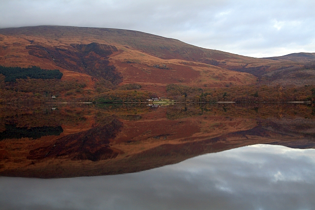
Coire Corrach is a stunning glacial valley located in Stirlingshire, Scotland. Nestled within the picturesque landscape of the Trossachs National Park, this corrie offers breathtaking views and a rich geological history.

Formed during the last Ice Age, Coire Corrach was shaped by the slow movement of glaciers that carved out its distinctive U-shaped valley. Surrounded by towering mountains and rugged cliffs, the corrie is a testament to the raw power of glacial erosion.

The valley itself is home to a diverse range of flora and fauna. Its sheltered location provides a haven for various plant species, including heather, bilberry, and saxifrage. The surrounding hillsides are often dotted with grazing sheep, further adding to the idyllic scenery.

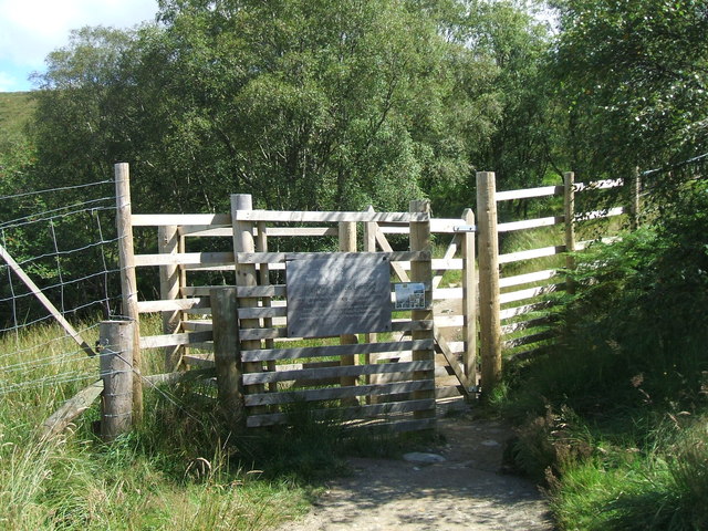
Coire Corrach also boasts a network of walking trails that allow visitors to explore its natural wonders. These paths wind through the valley, offering panoramic views of the surrounding countryside and the opportunity to spot wildlife such as red deer, golden eagles, and peregrine falcons.

In addition to its natural beauty, Coire Corrach also holds historical significance. It is believed to have been a popular hunting ground for ancient Scottish clans, who would have taken advantage of its abundant wildlife.

Overall, Coire Corrach is a captivating destination for nature lovers and outdoor enthusiasts. Its combination of stunning landscapes, diverse wildlife, and cultural heritage make it a must-visit location in Stirlingshire.

If you have any feedback on the listing, please let us know in the comments section below.

Coire Corrach Images

Images are sourced within 2km of 56.160774/-4.6238102 or Grid Reference NS3799. Thanks to Geograph Open Source API. All images are credited.

Loch Lomond and the War Memorial
Sheepfanks above Rowardennan Old sheep fanks on the hillside, adjacent to the path from the Ptarmigan ridge of Ben Lomond.
Sheepfanks above Rowardennan
Old sheep fanks on the hillside, adjacent to the path from the Ptarmigan ridge of Ben Lomond.
The path towards Ptarmigan Looking up the path towards the Ptarmigan ridge of Ben Lomond, with the waterfall of Spùt Ban on the right
The path towards Ptarmigan
Looking up the path towards the Ptarmigan ridge of Ben Lomond, with the waterfall of Spùt Ban on the right
Footbridge across a minor burn The main path onto Ben Lomond crosses a small burn in the forests.
Footbridge across a minor burn
The main path onto Ben Lomond crosses a small burn in the forests.
Forest felling allows a view to Ptarmigan
Gate at the edge of the forest A gateway in the deer fence between the forests of the lower slopes and the open upper slopes of Ben Lomond
Gate at the edge of the forest
A gateway in the deer fence between the forests of the lower slopes and the open upper slopes of Ben Lomond
Footpath ascending Ben Lomond Part of the main tourist track up the southernmost Munro, with one of the burns draining into Coire Corrach on the left.
Footpath ascending Ben Lomond
Part of the main tourist track up the southernmost Munro, with one of the burns draining into Coire Corrach on the left.
Loch Lomond A wet morning at Rowardennan
Loch Lomond
A wet morning at Rowardennan
Glaciated rocks on the shore of Loch Lomond at Rowardennan
Ben Lomond from the Pier, Rowardennan
Leaving the forest and ascending Ben Lomond
Rowardennan car park Information centre and toilet facility located in the main car park for access to Ben Lomond.
Rowardennan car park
Information centre and toilet facility located in the main car park for access to Ben Lomond.
Track in Rowardennan Forest The track runs throughout the length of the forest.
Track in Rowardennan Forest
The track runs throughout the length of the forest.
Gate on the Ben Lomond hill path Gate near the edge of Rowardennan Forest allows access to Ben Lomond.
Gate on the Ben Lomond hill path
Gate near the edge of Rowardennan Forest allows access to Ben Lomond.
Hillside beside path to Ben Lomond The most used path for Ben Lomond starts from Rowardennan and climbs through woodland emerging on open hill slopes. This view from the path at around 350m is across the adjacent slope and beyond to the Graham, Beinn Bhreac, on the far side of Loch Lomond.
Hillside beside path to Ben Lomond
The most used path for Ben Lomond starts from Rowardennan and climbs through woodland emerging on open hill slopes. This view from the path at around 350m is across the adjacent slope and beyond to the Graham, Beinn Bhreac, on the far side of Loch Lomond.
Rowardennan Lodge Youth Hostel Rowardennan Lodge Youth Hostel is situated on the banks of Loch Lomond, complete with its own jetty. This 75 bed Youth Hostel provides quality, budget accommodation, offering both multi-share rooms and private rooms. Facilities include a large communal lounge with spectacular views across Loch Lomond.
Rowardennan Lodge Youth Hostel
Rowardennan Lodge Youth Hostel is situated on the banks of Loch Lomond, complete with its own jetty. This 75 bed Youth Hostel provides quality, budget accommodation, offering both multi-share rooms and private rooms. Facilities include a large communal lounge with spectacular views across Loch Lomond.
Ben Lomond hill path
Track to Ben Lomond
Track to Ben Lomond
Show me another place!

Coire Corrach is located at Grid Ref: NS3799 (Lat: 56.160774, Lng: -4.6238102)

Unitary Authority: Stirling

Police Authority: Forth Valley

What 3 Words

///casually.allowable.skyrocket. Near Garelochhead, Argyll & Bute

Nearby Locations

Coire Corrach

Related Wikis

Rowardennan

Rowardennan (Gaelic: Rubha Aird Eònain) is a small rural community on the eastern shore of Loch Lomond in Stirling council, Scotland. It is mainly known...

Eilean nan Deargannan

Eilean nan Deargannan (sometimes written as Eilean Deargannan) is a small island in Loch Lomond, in west central Scotland. It lies between Rowardennan...

Inverbeg

Inverbeg is a settlement in Argyll and Bute, Scotland. Its Ordnance Survey grid reference is NS3497.It is on the western shore of Loch Lomond. There has...

Ben Lomond

Ben Lomond (Scottish Gaelic: Beinn Laomainn, 'Beacon Mountain'), 974 metres (3,196 ft), is a mountain in the Scottish Highlands. Situated on the eastern...

Ross Isles

The Ross Isles are two small islands in Loch Lomond, in west central Scotland. They lie opposite Luss, and are named after the promontory on the east shore...

Loch Dubh (Loch Ard Forest)

Loch Dubh ("Black Loch") is a lochan on the Duchray Water in the western part of Loch Ard Forest in the Central Highlands of Scotland. == Location == Loch...

Beinn Bhreac (Arrochar)

Beinn Bhreac (681 m) is a mountain in Argyll and Bute, Scotland. It is part of the Luss Hills, a southern subrange of the Grampian Mountains. Rising from...

West Loch Lomond Cycle Path

The West Loch Lomond Cycle Path is a cycle path that runs from Arrochar and Tarbet railway station, at the upper end of Loch Lomond in Scotland, to Balloch...

Nearby Amenities

Located within 500m of 56.160774,-4.6238102
Coire Corrach
Place: locality
Lat/Long: 56.1616577/-4.6258692
The data included in this document is from www.openstreetmap.org. The data is made available under ODbL.

Have you been to Coire Corrach?

Leave your review of Coire Corrach below (or comments, questions and feedback).