Bloody Point

Coastal Marsh, Saltings in Suffolk Babergh

England

Bloody Point

Shore, Shotley Gate
Shore, Shotley Gate Credit: Robin Webster

Bloody Point, located in Suffolk, is a coastal marsh area known for its unique and diverse ecosystem. Situated along the coast, this area consists of vast stretches of marshlands and saltings, making it an essential habitat for various flora and fauna.

The marshlands of Bloody Point are characterized by low-lying, waterlogged areas with an abundance of vegetation. These marshes are typically found in the tidal zone, where the land is regularly flooded and drained by the tides. The presence of saltwater in these marshes creates a harsh environment for many plants and animals, leading to the development of specialized species that can tolerate high salinity levels.

Saltings, on the other hand, are areas of land that are typically found above the tidal zone and are less frequently flooded. The soil in these areas is usually saline due to the accumulation of salt over time. As a result, the vegetation in the saltings is adapted to thrive in such conditions, with plants like samphire and sea lavender being common sights.

Bloody Point's coastal marshes and saltings provide a vital habitat for a wide range of wildlife. Various bird species, including waders like curlews and redshanks, can be seen foraging for food in the mudflats. Additionally, the marshes and saltings serve as important breeding grounds for many invertebrates, such as crabs and shrimps, which in turn attract larger predators like fish and seals.

In conclusion, Bloody Point in Suffolk is a remarkable coastal area characterized by its extensive marshlands and saltings. Its unique ecosystem supports a diverse range of plant and animal life, making it a significant site for conservation and ecological studies.

If you have any feedback on the listing, please let us know in the comments section below.

Bloody Point Images

Images are sourced within 2km of 51.95927/1.2812812 or Grid Reference TM2534. Thanks to Geograph Open Source API. All images are credited.

Shore, Shotley Gate
Shore, Shotley Gate
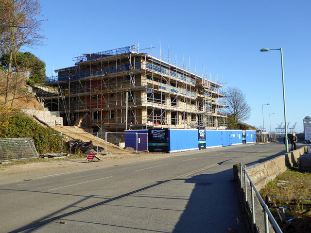
Shotley Lodge under construction, 2017 Flats on a site where there was some sort of house before.
Shotley Lodge under construction, 2017
Flats on a site where there was some sort of house before.
The Bristol Arms, Shotley Gate The barriers are around road work across the road from the pub, not the pub itself.
The Bristol Arms, Shotley Gate
The barriers are around road work across the road from the pub, not the pub itself.
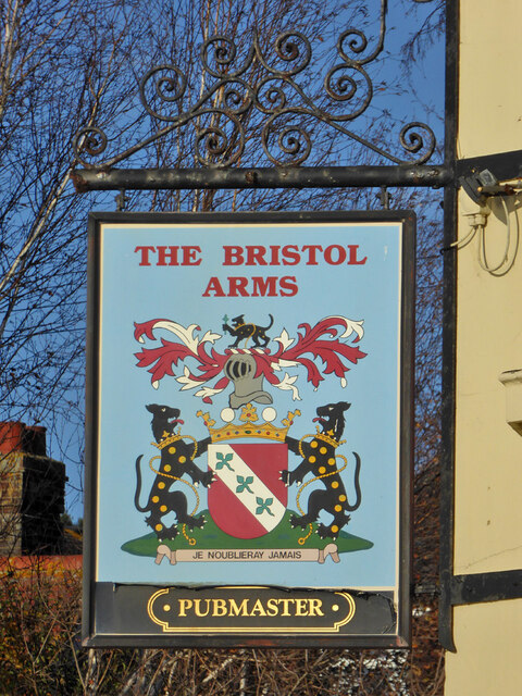
The Bristol Arms - inn sign
Welcome to Shotley Marina An unusually welcoming marina.
Welcome to Shotley Marina
An unusually welcoming marina.
Landing stage, Shotley Marina Used by the small foot ferry to Felixstowe and Harwich. The backdrop is 'Taipei Triumph' alongside at Felixstowe.
Landing stage, Shotley Marina
Used by the small foot ferry to Felixstowe and Harwich. The backdrop is 'Taipei Triumph' alongside at Felixstowe.
Boats out of water, Shotley Marina The serious boat in the middle is 'Titan Discovery', an underwater survey and operations vessel.
Boats out of water, Shotley Marina
The serious boat in the middle is 'Titan Discovery', an underwater survey and operations vessel.
Lock, Shotley Marina A public right-of-way crosses the lower gates. Straight ahead is a Martello tower, with a water tank not very reverentially placed on top.
Lock, Shotley Marina
A public right-of-way crosses the lower gates. Straight ahead is a Martello tower, with a water tank not very reverentially placed on top.
Boats in Shotley Marina Impounded above the lock.
Boats in Shotley Marina
Impounded above the lock.
Ships alongside at Felixstowe A very busy container port.
Ships alongside at Felixstowe
A very busy container port.
'Taipei Triumph' alongside at Felixstowe Reportedly built in 2017, so, if true, this must have been close to a maiden revenue earning voyage.
'Taipei Triumph' alongside at Felixstowe
Reportedly built in 2017, so, if true, this must have been close to a maiden revenue earning voyage.
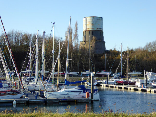
Martello/water tower above Shotley Marina A grade II listed building, despite the tower from the Napoleonic wars being spoiled by a comparatively modern extension and water tank on top.
Martello/water tower above Shotley Marina
A grade II listed building, despite the tower from the Napoleonic wars being spoiled by a comparatively modern extension and water tank on top.
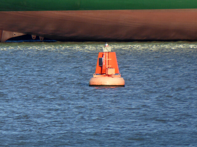
Pepys buoy, Harwich Haven On the near (SW) side of the deep dredged channel.
Pepys buoy, Harwich Haven
On the near (SW) side of the deep dredged channel.
'Allen Gardiner' turns back up the Orwell A 'river cruise restaurant' from and to Ipswich. The Fagbury buoy is on the left, marking the far (NE) side of the deep channel.
'Allen Gardiner' turns back up the Orwell
A 'river cruise restaurant' from and to Ipswich. The Fagbury buoy is on the left, marking the far (NE) side of the deep channel.
MV 'Allen Gardiner' heads up the Orwell A 'river cruise restaurant' from and to Ipswich. The red buoy, on this side of the deep channel, is called Bamburgh. The yellow buoy, on the other side, marks the start of a 6 knot speed limit up the river, and is just about on the port authority boundary between Harwich Haven and Ipswich.
MV 'Allen Gardiner' heads up the Orwell
A 'river cruise restaurant' from and to Ipswich. The red buoy, on this side of the deep channel, is called Bamburgh. The yellow buoy, on the other side, marks the start of a 6 knot speed limit up the river, and is just about on the port authority boundary between Harwich Haven and Ipswich.
Lightship LV20 moored, Harwich Haven Apparently laid up at a Trinity House mooring buoy.
Lightship LV20 moored, Harwich Haven
Apparently laid up at a Trinity House mooring buoy.
Moored lightship, Harwich Haven Apparently laid up at a Trinity House mooring buoy. There is no obvious identity, viewed from this angle, its last station name would have been fixed on the framework towards the stern. It is not LV 22, which was here a year later.
Moored lightship, Harwich Haven
Apparently laid up at a Trinity House mooring buoy. There is no obvious identity, viewed from this angle, its last station name would have been fixed on the framework towards the stern. It is not LV 22, which was here a year later.
Lock, Shotley Marina The gates have reminders that the speed limit on the Stour and Harwich Harbour is 8 knots, and on the Orwell 6 knots. There is also a warning about cross tides. Although the marina is called Shotley Marina, the lifebelt on the right has 'Shotley Point Marina' on it - an earlier name?
Lock, Shotley Marina
The gates have reminders that the speed limit on the Stour and Harwich Harbour is 8 knots, and on the Orwell 6 knots. There is also a warning about cross tides. Although the marina is called Shotley Marina, the lifebelt on the right has 'Shotley Point Marina' on it - an earlier name?
Show me another place!

Bloody Point is located at Grid Ref: TM2534 (Lat: 51.95927, Lng: 1.2812812)

Administrative County: Suffolk

District: Babergh

Police Authority: Suffolk

What 3 Words

///tougher.tomato.bolsters. Near Shotley Gate, Suffolk

Related Wikis

Shotley Battery

Shotley Battery was built in 1865 on the Shotley Peninsula to guard the port of Felixstowe, within HMS Ganges Naval Training school, on the same site as...

RNTE Shotley

Royal Naval Training Establishment Shotley, known in the Royal Navy as HMS Ganges, was a naval training establishment at Shotley, near Ipswich in Suffolk...

HMS Ganges (shore establishment)

HMS Ganges was a training ship and later stone frigate of the Royal Navy. She was established as a boys' training establishment in 1865, and was based...

HMS Ganges mast

A ship's mast stands on the site of the Royal Navy shore establishment HMS Ganges at Shotley, Suffolk in England. It was formerly used for mast climbing...

Nearby Amenities

Located within 500m of 51.95927,1.2812812
Pub
The Shipwreck
Addr City: Ipswich
Addr Locality: Shotley Marina
Addr Postcode: IP9 1QJ
Addr Village: Shotley Gate
Fhrs Id: 526301
Source Addr: FSA Food Hygiene Ratings Database
Lat/Long: 51.9573495/1.2755727
Ferry Terminal
Ferry: yes
Public Transport: station
Lat/Long: 51.9572378/1.2768471
Bus Stop
Marina
Bus: yes
Naptan AtcoCode: 390010811
Naptan Bearing: W
Naptan CommonName: Marina
Naptan Indicator: adj
Naptan Landmark: Marina
Naptan NaptanCode: sufjmwam
Naptan Street: King Edward VII Drive
Naptan Verified: no
Public Transport: platform
Source: naptan_import
Lat/Long: 51.9577349/1.27628
HMS Ganges Museum
Tourism: museum
Website: https://www.hmsgangesmuseum.org.uk/
Wikidata: Q113370035
Lat/Long: 51.9573254/1.2758497
Seamark Light Category: directional
Seamark Light Character: F
Seamark Light Colour: yellow
Seamark Light Height: 3
Seamark Light Orientation: 339.5
Seamark Light Range: 1
Seamark Light Reference: A 2213.5
Seamark Type: light_minor
Source: US NGA Pub. 114. 2011-04-02
Lat/Long: 51.9577083/1.2768201
Seamark Buoy Lateral Category: port
Seamark Buoy Lateral Colour: red
Seamark Buoy Lateral Shape: can
Seamark Buoy Lateral System: iala-a
Seamark Light Character: Fl
Seamark Light Colour: red
Seamark Light Group: 4
Seamark Light Period: 15
Seamark Name: Pepys
Seamark Type: buoy_lateral
Lat/Long: 51.9623873/1.2815409
Bench
Backrest: yes
Material: wood
Seats: 3
Lat/Long: 51.9610658/1.2783039
Bench
Backrest: yes
Material: wood
Seats: 3
Lat/Long: 51.9613313/1.277993
Waste Basket
Waste: dog_excrement
Lat/Long: 51.9613914/1.2778853
Bench
Backrest: yes
Material: plastic
Seats: 3
Lat/Long: 51.9603784/1.2786717
Bench
Backrest: yes
Material: wood
Seats: 3
Lat/Long: 51.9606703/1.2785959
Bench
Backrest: yes
Material: wood
Seats: 3
Lat/Long: 51.9605222/1.2786413
Bench
Backrest: yes
Material: wood
Seats: 3
Lat/Long: 51.9608103/1.2785039
Bench
Backrest: yes
Material: wood
Seats: 3
Lat/Long: 51.960221/1.2787679
Bench
Backrest: yes
Material: wood
Seats: 3
Lat/Long: 51.9600909/1.2787596
Bench
Backrest: yes
Material: wood
Seats: 3
Lat/Long: 51.9599142/1.2786926
Bench
Backrest: yes
Material: plastic
Seats: 3
Lat/Long: 51.9596952/1.2785588
Bench
Backrest: yes
Material: wood
Seats: 4
Lat/Long: 51.9592956/1.2782626
Bench
Backrest: yes
Material: wood
Seats: 3
Lat/Long: 51.9590343/1.2781001
Bench
Backrest: yes
Material: plastic
Seats: 3
Lat/Long: 51.9591306/1.2781681
Bench
Backrest: yes
Material: plastic
Seats: 3
Lat/Long: 51.9589539/1.2780239
Bench
Backrest: yes
Material: wood
Seats: 3
Lat/Long: 51.9588897/1.2779702
Bench
Backrest: yes
Material: wood
Seats: 3
Lat/Long: 51.9585378/1.2776606
Bench
Backrest: yes
Material: wood
Seats: 3
Lat/Long: 51.9584109/1.2775317
Bench
Backrest: yes
Material: plastic
Seats: 4
Lat/Long: 51.9583748/1.2774754
Bench
Backrest: yes
Material: wood
Seats: 3
Lat/Long: 51.958294/1.2773716
Bench
Backrest: yes
Material: wood
Seats: 3
Lat/Long: 51.9582205/1.2772842
Bench
Backrest: yes
Material: wood
Seats: 3
Lat/Long: 51.9581677/1.2771708
Bench
Backrest: yes
Material: wood
Seats: 3
Lat/Long: 51.9581398/1.2771117
Waste Basket
Waste: dog_excrement
Lat/Long: 51.9580498/1.2769152
The data included in this document is from www.openstreetmap.org. The data is made available under ODbL.

Have you been to Bloody Point?

Leave your review of Bloody Point below (or comments, questions and feedback).