Barley Bank

Coastal Marsh, Saltings in Kent Swale

England

Barley Bank

Wellmarsh Creek Elmley Island National Nature Reserve on the Isle of Sheppey in North Kent teems with wildlife, including the country’s largest lowland collection of breeding waders. It is about as remote as you can be near London. It is one of the largest bird reserves in England.

This is on the southern side of the island, looking across Wellmarsh Creek which is one of the inlets of The Swale.
Wellmarsh Creek Credit: Marathon

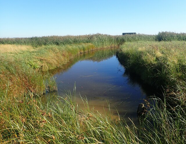
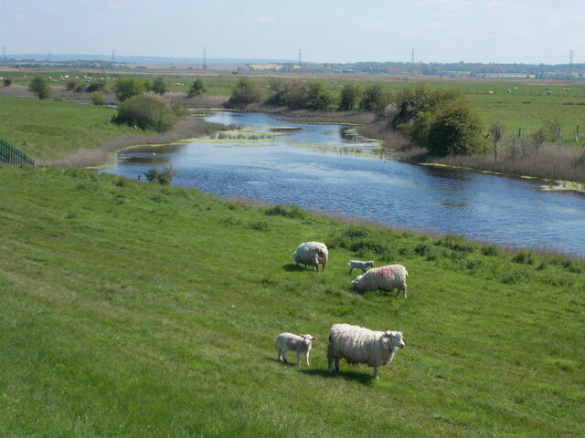
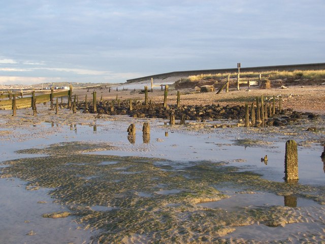
Barley Bank is a coastal marsh and saltings area located in Kent, England. Situated along the southeastern coast of the country, it is known for its stunning natural beauty and diverse ecosystem.

Covering an expansive area, Barley Bank is characterized by its unique marshland environment, which consists of a mixture of salt marshes, mudflats, and saline lagoons. These habitats are formed by the tides and are home to a wide variety of plant and animal species.

The salt marshes are dominated by plants such as sea lavender, sea aster, and glasswort, which have adapted to the saline conditions. These plants provide essential food and shelter for numerous bird species, including waders like redshanks, dunlins, and curlews. Migratory birds also use the area as a resting and feeding ground during their long journeys.

The mudflats of Barley Bank are rich in nutrients and attract a diverse range of invertebrates such as worms, snails, and crabs, which in turn provide a food source for wading birds and other wildlife. The saline lagoons, on the other hand, support a variety of fish species and serve as important breeding grounds for marine life.

Barley Bank is not only a haven for wildlife but also offers visitors the opportunity to enjoy its natural splendor. The area is popular among nature enthusiasts, birdwatchers, and photographers who come to witness the abundance of birdlife and capture the breathtaking coastal landscapes.

In conclusion, Barley Bank in Kent is a coastal marsh and saltings that boasts a rich and diverse ecosystem. Its salt marshes, mudflats, and saline lagoons provide essential habitats for a wide range of plant and animal species, making it a must-visit destination for nature lovers.

If you have any feedback on the listing, please let us know in the comments section below.

Barley Bank Images

Images are sourced within 2km of 51.363177/0.82433287 or Grid Reference TQ9666. Thanks to Geograph Open Source API. All images are credited.

Wellmarsh Creek Elmley Island National Nature Reserve on the Isle of Sheppey in North Kent teems with wildlife, including the country’s largest lowland collection of breeding waders. It is about as remote as you can be near London. It is one of the largest bird reserves in England.

This is on the southern side of the island, looking across Wellmarsh Creek which is one of the inlets of The Swale.
Wellmarsh Creek
Elmley Island National Nature Reserve on the Isle of Sheppey in North Kent teems with wildlife, including the country’s largest lowland collection of breeding waders. It is about as remote as you can be near London. It is one of the largest bird reserves in England. This is on the southern side of the island, looking across Wellmarsh Creek which is one of the inlets of The Swale.
Elmley Island National Nature Reserve Elmley Island National Nature Reserve on the Isle of Sheppey in North Kent teems with wildlife, including the country’s largest lowland collection of breeding waders. It is about as remote as you can be near London. It is one of the largest bird reserves in England.

This is to the north of one of the bird hides. The wind turbines are on Eastchurch Marshes.
Elmley Island National Nature Reserve
Elmley Island National Nature Reserve on the Isle of Sheppey in North Kent teems with wildlife, including the country’s largest lowland collection of breeding waders. It is about as remote as you can be near London. It is one of the largest bird reserves in England. This is to the north of one of the bird hides. The wind turbines are on Eastchurch Marshes.
Wellmarsh Creek Elmley Island National Nature Reserve on the Isle of Sheppey in North Kent teems with wildlife, including the country’s largest lowland collection of breeding waders. It is about as remote as you can be near London. It is one of the largest bird reserves in England.

This is on the southern side of the island, looking across Wellmarsh Creek which is one of the inlets of The Swale. The mainland can be seen in the far distance.
Wellmarsh Creek
Elmley Island National Nature Reserve on the Isle of Sheppey in North Kent teems with wildlife, including the country’s largest lowland collection of breeding waders. It is about as remote as you can be near London. It is one of the largest bird reserves in England. This is on the southern side of the island, looking across Wellmarsh Creek which is one of the inlets of The Swale. The mainland can be seen in the far distance.
View from a birdwatching hide on Elmley Island National Nature Reserve Elmley Island National Nature Reserve on the Isle of Sheppey in North Kent teems with wildlife, including the country’s largest lowland collection of breeding waders. It is about as remote as you can be near London. It is one of the largest bird reserves in England.

This is towards the southern side of the island, looking out from one of the birdwatching hides to the north of Wellmarsh Creek. It looks along Elmley Fleet. The wind turbines are on Eastchurch Marshes.
View from a birdwatching hide on Elmley Island National Nature Reserve
Elmley Island National Nature Reserve on the Isle of Sheppey in North Kent teems with wildlife, including the country’s largest lowland collection of breeding waders. It is about as remote as you can be near London. It is one of the largest bird reserves in England. This is towards the southern side of the island, looking out from one of the birdwatching hides to the north of Wellmarsh Creek. It looks along Elmley Fleet. The wind turbines are on Eastchurch Marshes.
View towards a birdwatching hide on Elmley Island National Nature Reserve Elmley Island National Nature Reserve on the Isle of Sheppey in North Kent teems with wildlife, including the country’s largest lowland collection of breeding waders. It is about as remote as you can be near London. It is one of the largest bird reserves in England.

This is towards the southern side of the island, looking towards one of the birdwatching hides to the north of Wellmarsh Creek. The view from the birdhide can be seen at <a title="https://www.geograph.org.uk/photo/6973424" href="https://www.geograph.org.uk/photo/6973424">Link</a>
View towards a birdwatching hide on Elmley Island National Nature Reserve
Elmley Island National Nature Reserve on the Isle of Sheppey in North Kent teems with wildlife, including the country’s largest lowland collection of breeding waders. It is about as remote as you can be near London. It is one of the largest bird reserves in England. This is towards the southern side of the island, looking towards one of the birdwatching hides to the north of Wellmarsh Creek. The view from the birdhide can be seen at Link
Saxon Shore Way alongside The Swale Easy walking on the level next to the River Swale with its mudflats and tidal water channel.
Saxon Shore Way alongside The Swale
Easy walking on the level next to the River Swale with its mudflats and tidal water channel.
Saxon Shore Way - wrecked boat
Low tide at Conyer Creek Near the confluence with the River Swale.
Low tide at Conyer Creek
Near the confluence with the River Swale.
Approaching Conyer at Conyer Creek
Orchard near to the Ship Inn, Conyer
The eastern side of Conyer Creek
Old fence next to the Swale
Sheep and lambs by the Swale
Conyer Creek Conyer Creek is an interesting place with boats, houses along the bank on the east side as well as the Saxon Shore Way accessing both sides of the creek. The Creek then widens as it passes through the marshes to reach The Swale. This view is from the Saxon Shore Way on the west side of the creek.
Conyer Creek
Conyer Creek is an interesting place with boats, houses along the bank on the east side as well as the Saxon Shore Way accessing both sides of the creek. The Creek then widens as it passes through the marshes to reach The Swale. This view is from the Saxon Shore Way on the west side of the creek.
The Saxon Shore Way alongside Conyer Creek Conyer Creek is an interesting place with boats, houses along North Quay as well as the Saxon Shore Way accessing both sides of the creek. The Creek then widens as it passes through the marshes to reach The Swale. This view is of the Saxon Shore Way on the west side of the creek. The houses are alongside North Quay on the east side of the creek.
The Saxon Shore Way alongside Conyer Creek
Conyer Creek is an interesting place with boats, houses along North Quay as well as the Saxon Shore Way accessing both sides of the creek. The Creek then widens as it passes through the marshes to reach The Swale. This view is of the Saxon Shore Way on the west side of the creek. The houses are alongside North Quay on the east side of the creek.
Footpath alongside Conyer Creek Conyer Creek is an interesting place with boats, houses along the bank on the east side as well as the Saxon Shore Way accessing both sides of the creek. On the east side though the Saxon Shore Way heads straight up to The Swale while this path hugs the bank of the creek and gives good views of Conyer Creek as it passes through the marshes to reach The Swale.
Footpath alongside Conyer Creek
Conyer Creek is an interesting place with boats, houses along the bank on the east side as well as the Saxon Shore Way accessing both sides of the creek. On the east side though the Saxon Shore Way heads straight up to The Swale while this path hugs the bank of the creek and gives good views of Conyer Creek as it passes through the marshes to reach The Swale.
Looking across the salt marsh to Conyer Creek Conyer Creek is an interesting place with boats, houses along North Quay on the east side, as well as the Saxon Shore Way accessing both sides of the creek. On the east side though the Saxon Shore Way heads straight up to The Swale, while a side path hugs the bank of the creek and gives good views of Conyer Creek as it passes through the marshes to reach The Swale as seen here.
Looking across the salt marsh to Conyer Creek
Conyer Creek is an interesting place with boats, houses along North Quay on the east side, as well as the Saxon Shore Way accessing both sides of the creek. On the east side though the Saxon Shore Way heads straight up to The Swale, while a side path hugs the bank of the creek and gives good views of Conyer Creek as it passes through the marshes to reach The Swale as seen here.
The Saxon Shore Way alongside Conyer Creek Conyer Creek is an interesting place with boats, houses along North Quay as well as the Saxon Shore Way accessing both sides of the creek. The Creek then widens as it passes through the marshes to reach The Swale. This view is of the Saxon Shore Way on the west side of the creek. Ahead it turns left and left again to pass round the head of the creek. The view in the other direction can be seen at <a title="https://www.geograph.org.uk/photo/5154352" href="https://www.geograph.org.uk/photo/5154352">Link</a>
The Saxon Shore Way alongside Conyer Creek
Conyer Creek is an interesting place with boats, houses along North Quay as well as the Saxon Shore Way accessing both sides of the creek. The Creek then widens as it passes through the marshes to reach The Swale. This view is of the Saxon Shore Way on the west side of the creek. Ahead it turns left and left again to pass round the head of the creek. The view in the other direction can be seen at Link
Show me another place!

Barley Bank is located at Grid Ref: TQ9666 (Lat: 51.363177, Lng: 0.82433287)

Administrative County: Kent

District: Swale

Police Authority: Kent

What 3 Words

///blindfold.hamsters.guilty. Near Teynham, Kent

Related Wikis

Conyer

Conyer is a hamlet within Teynham civil parish in the borough of Swale in Kent, England. It is located around one mile north of the village of Teynham...

Teynham Street

Teynham Street is a hamlet in the Swale district, in the English county of Kent. It is near the village of Teynham. == References == Philip's Navigator...
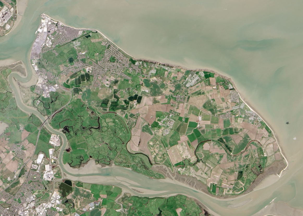
Isle of Sheppey

The Isle of Sheppey is an island off the northern coast of Kent, England, neighbouring the Thames Estuary, centred 42 miles (68 km) from central London...

Sittingbourne and Sheppey (UK Parliament constituency)

Sittingbourne and Sheppey is a constituency in Kent represented in the House of Commons of the UK Parliament since 2010 by Gordon Henderson, a Conservative...
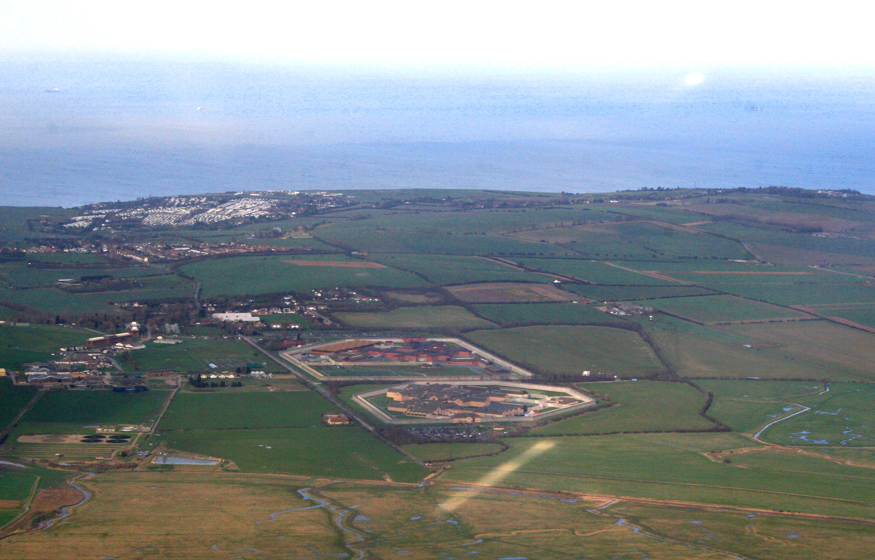
HM Prison Elmley

HM Prison Elmley is a local Category B/C men's prison, located close to the village of Eastchurch on the Isle of Sheppey, Kent. The term 'local' means...

The Swale

The Swale is a tidal channel of the Thames estuary that separates the Isle of Sheppey from the rest of Kent. On its banks is a 6,509.4-hectare (16,085...

Teynham railway station

Teynham railway station is on the Chatham Main Line in England, serving the village of Teynham, Kent. It is 47 miles 74 chains (77.1 km) down the line...

HM Prison Swaleside

HM Prison Swaleside is a Category B men's prison, located close to the village of Eastchurch on the Isle of Sheppey, Kent. Swaleside forms part of the...

Nearby Amenities

Located within 500m of 51.363177,0.82433287
Seamark Buoy Lateral Category: port
Seamark Buoy Lateral Colour: red
Seamark Buoy Lateral Shape: can
Seamark Buoy Lateral System: iala-a
Seamark Light Character: Fl
Seamark Light Colour: red
Seamark Light Period: 2
Seamark Name: No 4
Seamark Type: buoy_lateral
Lat/Long: 51.3611835/0.8302831
The data included in this document is from www.openstreetmap.org. The data is made available under ODbL.

Have you been to Barley Bank?

Leave your review of Barley Bank below (or comments, questions and feedback).