St Mary's Marshes

Coastal Marsh, Saltings in Kent

England

St Mary's Marshes

Former Parish Church of St Mary, St Mary Hoo
Former Parish Church of St Mary, St Mary Hoo Credit: JThomas

St Mary's Marshes is a coastal marsh located in the county of Kent, England. Situated along the eastern coast, it is a significant part of the unique landscape known as the Romney Marshes. The marshes cover an extensive area and stretch from the town of Lydd to the historic village of Dymchurch.

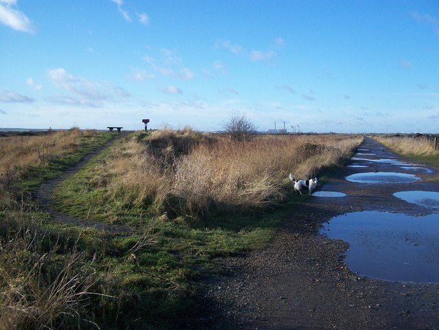
St Mary's Marshes consist of a mixture of marshland and saltings, which are areas of land that are periodically flooded by seawater. The marshes are characterized by their low-lying, flat terrain and are dissected by numerous drainage ditches and small streams. The area is renowned for its rich biodiversity, with a variety of plant and animal species calling it home.

The marshes are an important habitat for both resident and migratory birds. It serves as a breeding ground for several species, including the rare bittern and marsh harrier. During the winter months, large flocks of wading birds, such as avocets and dunlins, can be observed feeding on the mudflats and saltmarshes.

The landscape of St Mary's Marshes is also of historical and cultural significance. It has been shaped by centuries of human activity, including sheep farming and salt production. The remains of old salt pans and sheep folds can still be seen scattered throughout the marshland, providing a glimpse into the area's past.

Due to its ecological importance, St Mary's Marshes is designated as a Site of Special Scientific Interest (SSSI) and is also part of the wider Romney Marshes Special Protection Area (SPA). These designations ensure that the marshes are protected and managed sustainably to preserve their unique natural heritage for future generations to enjoy.

If you have any feedback on the listing, please let us know in the comments section below.

St Mary's Marshes Images

Images are sourced within 2km of 51.476428/0.59162826 or Grid Reference TQ8078. Thanks to Geograph Open Source API. All images are credited.

Former Parish Church of St Mary, St Mary Hoo
The former church of St Mary Hoo The small village of St Mary Hoo is one of the most attractive on the Hoo Peninsula. It is situated on a no through road leading off Ratcliffe Highway. The church of St Mary has been added to and changed over many different centuries from medieval times. The chancel was rebuilt in the late 19th century and the tower is Perpendicular. 

The churchyard is particularly attractive and features many extra resources such as picnic tables, a swing and this small garden called Church Lane. The reason for this is that the church was declared redundant at the end of the 20th century and is now a family home - see <span class="nowrap"><a title="www.kentarchaeology.org.uk/research/monumental-inscriptions/hoo" rel="nofollow ugc noopener" href="http://www.kentarchaeology.org.uk/research/monumental-inscriptions/hoo">Link</a><img style="margin-left:2px;" alt="External link" title="External link - shift click to open in new window" src="https://s1.geograph.org.uk/img/external.png" width="10" height="10"/></span>
The former church of St Mary Hoo
The small village of St Mary Hoo is one of the most attractive on the Hoo Peninsula. It is situated on a no through road leading off Ratcliffe Highway. The church of St Mary has been added to and changed over many different centuries from medieval times. The chancel was rebuilt in the late 19th century and the tower is Perpendicular. The churchyard is particularly attractive and features many extra resources such as picnic tables, a swing and this small garden called Church Lane. The reason for this is that the church was declared redundant at the end of the 20th century and is now a family home - see LinkExternal link
The former churchyard of St Mary Hoo The small village of St Mary Hoo is one of the most attractive on the Hoo Peninsula. It is situated on a no through road leading off Ratcliffe Highway. The church of St Mary has been added to and changed over many different centuries from medieval times. The chancel was rebuilt in the late 19th century and the tower is Perpendicular. 

The churchyard is particularly attractive and features many extra resources such as picnic tables, a swing and this small garden called Church Lane. The reason for this is that the church was declared redundant at the end of the 20th century and is now a family home - see <span class="nowrap"><a title="www.kentarchaeology.org.uk/research/monumental-inscriptions/hoo" rel="nofollow ugc noopener" href="http://www.kentarchaeology.org.uk/research/monumental-inscriptions/hoo">Link</a><img style="margin-left:2px;" alt="External link" title="External link - shift click to open in new window" src="https://s1.geograph.org.uk/img/external.png" width="10" height="10"/></span>
The former churchyard of St Mary Hoo
The small village of St Mary Hoo is one of the most attractive on the Hoo Peninsula. It is situated on a no through road leading off Ratcliffe Highway. The church of St Mary has been added to and changed over many different centuries from medieval times. The chancel was rebuilt in the late 19th century and the tower is Perpendicular. The churchyard is particularly attractive and features many extra resources such as picnic tables, a swing and this small garden called Church Lane. The reason for this is that the church was declared redundant at the end of the 20th century and is now a family home - see LinkExternal link
St Mary Hoo This church, which has given its name to a village on the Hoo peninsula, is now a private house: <span class="nowrap"><a title="http://en.wikipedia.org/wiki/St_Mary_Hoo" rel="nofollow ugc noopener" href="http://en.wikipedia.org/wiki/St_Mary_Hoo">Link</a><img style="margin-left:2px;" alt="External link" title="External link - shift click to open in new window" src="https://s1.geograph.org.uk/img/external.png" width="10" height="10"/></span>.
St Mary Hoo
This church, which has given its name to a village on the Hoo peninsula, is now a private house: LinkExternal link.
Saltings near Shakespeare Farm These are saltings on the River Thames to the North of Shakespeare Farm West of Allhallows-on-Sea.
Saltings near Shakespeare Farm
These are saltings on the River Thames to the North of Shakespeare Farm West of Allhallows-on-Sea.
Micro Power Station near St Mary Hoo This power station is somewhat smaller than the others in the area. It generates electricity from methane extracted from the <a href="https://www.geograph.org.uk/photo/268449">TQ8177 : Shakespeare Farm Landfill Site</a> .
Micro Power Station near St Mary Hoo
This power station is somewhat smaller than the others in the area. It generates electricity from methane extracted from the TQ8177 : Shakespeare Farm Landfill Site .
Shakespeare Farm Landfill Site This is the reception office on Shakespeare Farm Landfill Site. The methane generated by the rotting garbage is fed to <a href="https://www.geograph.org.uk/photo/268446">TQ8177 : Micro Power Station near St Mary Hoo</a>
Shakespeare Farm Landfill Site
This is the reception office on Shakespeare Farm Landfill Site. The methane generated by the rotting garbage is fed to TQ8177 : Micro Power Station near St Mary Hoo
Footpath to Swigshole This is a view of St Mary’s Marshes on the Hoo Peninsula. The footpath to Swigshole follows the fence to the left of field drain as far as TQ811781 where the choice it to turn right for Swigshole or left for Allhallows.
Footpath to Swigshole
This is a view of St Mary’s Marshes on the Hoo Peninsula. The footpath to Swigshole follows the fence to the left of field drain as far as TQ811781 where the choice it to turn right for Swigshole or left for Allhallows.
St Marys Sea Wall This is the sea wall on the Kent bank of the Thames north of the St Marys Marshes. The Picture is looking towards the coryton Oil refinery on the Essex side of the river
St Marys Sea Wall
This is the sea wall on the Kent bank of the Thames north of the St Marys Marshes. The Picture is looking towards the coryton Oil refinery on the Essex side of the river
Footpath & Confused Geographer This is a photo of the footpath that runs along the sea wall on the Kent bank of the Thames. You can see a stile to the left of the gate and a confused geographer, who has a realisation that he may have got a grid ref wrong in the past. Just coz a landmark is on a map don't mean it is still there!!!
Footpath & Confused Geographer
This is a photo of the footpath that runs along the sea wall on the Kent bank of the Thames. You can see a stile to the left of the gate and a confused geographer, who has a realisation that he may have got a grid ref wrong in the past. Just coz a landmark is on a map don't mean it is still there!!!
Allhallows Footpath This is the footpath from Swigshole to Allhallows the 3m spot height is a few  metres beyond the gate.
Allhallows Footpath
This is the footpath from Swigshole to Allhallows the 3m spot height is a few metres beyond the gate.
Church Pond, St Mary Hoo On road junction of Hall Road (heading north) and Moat Farm Road (east-west).
St Mary's Church is just to the left of the photo, beside willow tree.
Green and white building in background is Pudding Cottage.
Church Pond, St Mary Hoo
On road junction of Hall Road (heading north) and Moat Farm Road (east-west). St Mary's Church is just to the left of the photo, beside willow tree. Green and white building in background is Pudding Cottage.
Footpath junction near Ross Farm Footpath from Newlands Farm heads straight to St Mary Hoo,reaching Moat Farm Road. Path heading right leads to Ratcliffe Highway near Bell Wood.
Footpath junction near Ross Farm
Footpath from Newlands Farm heads straight to St Mary Hoo,reaching Moat Farm Road. Path heading right leads to Ratcliffe Highway near Bell Wood.
Footpath on farm track Path leads through fields towards Dagnam Farm. Track from Ratcliffe Highway leads to fields in St Mary's Marshes.
Footpath on farm track
Path leads through fields towards Dagnam Farm. Track from Ratcliffe Highway leads to fields in St Mary's Marshes.
Pillbox at junction of footpaths Path on left leads to coast and then onto Allhallows via Dagnam Saltings. Path on right leads uphill to Ratcliffe Highway.
Pillbox at junction of footpaths
Path on left leads to coast and then onto Allhallows via Dagnam Saltings. Path on right leads uphill to Ratcliffe Highway.
Footpath bend on Sea Wall Path No.RS4 leads along seawall on left along coastline towards St Mary's Bay, around St Mary's Marshes. Path also winds through Dagnam Saltings heading right to Allhallows. The River Thames is in the background.
Footpath bend on Sea Wall
Path No.RS4 leads along seawall on left along coastline towards St Mary's Bay, around St Mary's Marshes. Path also winds through Dagnam Saltings heading right to Allhallows. The River Thames is in the background.
Stile on footpath, near Dagnam Saltings Path No.RS4 from Allhallows briefly leaves marshland on coast and travels into farmland going through hedgeline before returning to coastline to travel to St Mary's Bay.
Stile on footpath, near Dagnam Saltings
Path No.RS4 from Allhallows briefly leaves marshland on coast and travels into farmland going through hedgeline before returning to coastline to travel to St Mary's Bay.
Show me another place!

St Mary's Marshes is located at Grid Ref: TQ8078 (Lat: 51.476428, Lng: 0.59162826)

Unitary Authority: Medway

Police Authority: Kent

What 3 Words

///tragedy.behind.subway. Near Allhallows, Kent

Related Wikis

South Thames Estuary and Marshes

South Thames Estuary and Marshes is a 5,289-hectare (13,070-acre) biological Site of Special Scientific Interest which stretches between Gravesend and...

St Mary Hoo

St Mary Hoo is a village and civil parish in Kent, England. It is on the Hoo Peninsula in the borough of Medway. According to the 2001 census it had...

Thames Estuary

The Thames Estuary is where the River Thames meets the waters of the North Sea, in the south-east of Great Britain. == Limits == An estuary can be defined...

River Thames

The River Thames ( TEMZ), known alternatively in parts as the River Isis, is a river that flows through southern England including London. At 215 miles...

Have you been to St Mary's Marshes?

Leave your review of St Mary's Marshes below (or comments, questions and feedback).