Mill Marsh

Coastal Marsh, Saltings in Lincolnshire South Holland

England

Mill Marsh

Underneath the wires near Penn's Farm
Underneath the wires near Penn's Farm Credit: Jonathan Thacker

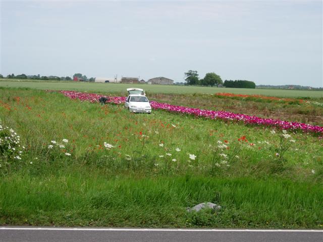
Mill Marsh is a coastal marshland located in Lincolnshire, England. It is situated in close proximity to the North Sea and is characterized by its unique landscape known as saltings. The marshland covers an area of approximately 100 hectares and is renowned for its diverse ecology and natural beauty.

The saltings of Mill Marsh are formed as a result of the tidal action of the North Sea. Twice a day, the marsh is flooded by the sea, creating a dynamic environment that supports a wide range of plant and animal species. The marsh is home to various types of salt-tolerant vegetation, such as sea lavender, thrift, and sea aster, which thrive in the saline conditions. These plants not only provide habitat and food sources for numerous bird species but also help stabilize the marshland.

Birdwatchers flock to Mill Marsh to observe the rich avian diversity that can be found here. The marsh serves as an important feeding and nesting ground for migratory birds, including wading birds like redshanks, curlews, and oystercatchers. Additionally, it attracts a variety of waterfowl, such as teal, wigeon, and shelduck.

Mill Marsh also plays a crucial role in coastal protection. The dense vegetation and intricate network of creeks and channels act as natural barriers, absorbing wave energy and reducing the risk of erosion and flooding.

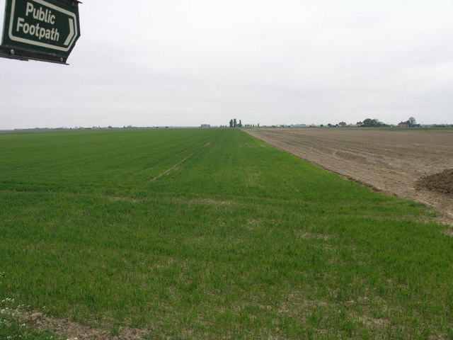
Visitors to Mill Marsh can enjoy the picturesque landscape by following the network of footpaths that wind through the marshland. The area offers a peaceful and serene experience, allowing visitors to connect with nature and appreciate the unique ecology of this coastal marsh.

If you have any feedback on the listing, please let us know in the comments section below.

Mill Marsh Images

Images are sourced within 2km of 52.831677/-0.046939358 or Grid Reference TF3127. Thanks to Geograph Open Source API. All images are credited.

Underneath the wires near Penn's Farm
Farm track off Low Gate
Field ditch off Common Road, Moulton Common
Man cutting flowers for sale, near the A17 Patches of flowers like this one, apparently grown for sale, border the A17 on this stretch.
Man cutting flowers for sale, near the A17
Patches of flowers like this one, apparently grown for sale, border the A17 on this stretch.
Big Field Big Tent The white spot on the horizon is a large marquee.  There is something a little uncomfortable about the fact that weeds grow happily at this field margin but the rest of the field remains lifeless.
Big Field Big Tent
The white spot on the horizon is a large marquee. There is something a little uncomfortable about the fact that weeds grow happily at this field margin but the rest of the field remains lifeless.
Paddock and Halesgate The buildings that lie beyond this paddock are part of Halesgate.
Paddock and Halesgate
The buildings that lie beyond this paddock are part of Halesgate.
Golden Lion This Golden Lion pub stands at the junction of Pipwell Gate and Seas End Road.
Golden Lion
This Golden Lion pub stands at the junction of Pipwell Gate and Seas End Road.
Footpath and Farm The footpath leads to the River Welland.  The farm is clearly operating on an industrial scale in its food production.
Footpath and Farm
The footpath leads to the River Welland. The farm is clearly operating on an industrial scale in its food production.
Farm Track and Shadow This farm track leads over the flat fields to the A17.  The white and red dots on the horizon, left, are lorries which are using this busy route.
Farm Track and Shadow
This farm track leads over the flat fields to the A17. The white and red dots on the horizon, left, are lorries which are using this busy route.
Flat Fenland Footpath This footpath leads from a road between Saracen's Head and Moulton Seas End, to the nearby A17.
Flat Fenland Footpath
This footpath leads from a road between Saracen's Head and Moulton Seas End, to the nearby A17.
Drain near Seas End Typical Lincolnshire Fens landscape: dead straight drain acting as the boundary between two fields. The trees on the horizon surround St Lambert's Hall, just over the boundary in <a href="https://www.geograph.org.uk/gridref/TF2926">TF2926</a>.
Drain near Seas End
Typical Lincolnshire Fens landscape: dead straight drain acting as the boundary between two fields. The trees on the horizon surround St Lambert's Hall, just over the boundary in TF2926.
Another drain near Seas End The farmland to the right is at 4 metres above sea level while the top of the bank to the left is 2 metres higher. There were several pairs of moor-hens darting in and out of the bank but non stayed to have their picture taken.
Another drain near Seas End
The farmland to the right is at 4 metres above sea level while the top of the bank to the left is 2 metres higher. There were several pairs of moor-hens darting in and out of the bank but non stayed to have their picture taken.
Farmland near Moulton Seas End The farmland here was successfully reclaimed from the marshes in the 17th century although the Romans had already built some sea defences earlier.
Farmland near Moulton Seas End
The farmland here was successfully reclaimed from the marshes in the 17th century although the Romans had already built some sea defences earlier.
Farm road on the Fens This farm road is at the end of Mill Marsh Road. It follows the line of the old sea bank and is considerably higher than the surrounding countryside.
Farm road on the Fens
This farm road is at the end of Mill Marsh Road. It follows the line of the old sea bank and is considerably higher than the surrounding countryside.
A blot on the landscape Fly tipping in the Fens alongside the track that leads to Mill Marsh Road.
A blot on the landscape
Fly tipping in the Fens alongside the track that leads to Mill Marsh Road.
Fen farmland Looking east from Carrington Road
Fen farmland
Looking east from Carrington Road
Ancient sea defences Mill Marsh Road runs along the top of the bank to the left, about a metre higher than the land straight in front of the view point. The farmland to the right of the drain is another metre lower. The bank was built in the 17th century during a large drainage project. The present day defences are several miles further west along the River Welland and northeast at the Wash.
Ancient sea defences
Mill Marsh Road runs along the top of the bank to the left, about a metre higher than the land straight in front of the view point. The farmland to the right of the drain is another metre lower. The bank was built in the 17th century during a large drainage project. The present day defences are several miles further west along the River Welland and northeast at the Wash.
Mill Marsh Road Looking towards Moulton Seas End. The road runs along the top of the old sea bank and the farmland is considerably lower either side. Middle Farm, shown in <a href="https://www.geograph.org.uk/photo/188647">TF3127 : Footpath and Farm</a>, is on the horizon.
Mill Marsh Road
Looking towards Moulton Seas End. The road runs along the top of the old sea bank and the farmland is considerably lower either side. Middle Farm, shown in TF3127 : Footpath and Farm, is on the horizon.
Show me another place!

Mill Marsh is located at Grid Ref: TF3127 (Lat: 52.831677, Lng: -0.046939358)

Administrative County: Lincolnshire

District: South Holland

Police Authority: Lincolnshire

What 3 Words

///property.shunning.soups. Near Whaplode, Lincolnshire

Nearby Locations

Mill Marsh

Related Wikis

Moulton Seas End

Moulton Seas End is a village in the civil parish of The Moultons and the South Holland district of Lincolnshire, England. It is 5 miles (8 km) north...

Parts of Holland

The Parts of Holland is a historical division of Lincolnshire, England, encompassing the south-east of the county. The name is still recognised locally...

Holbeach Clough

Holbeach Clough (today synonymous with Saracen's Head) is a fenland village in the South Holland district of Lincolnshire, England. It is just under 2...

Whaplode

Whaplode is a village and civil parish in the South Holland district of Lincolnshire, England. It is just west of the Prime Meridian. The parish includes...

Moulton Windmill

Moulton Windmill in the Lincolnshire village of Moulton, between Spalding and Holbeach is a restored windmill claimed to be the tallest tower mill in the...

Weston, Lincolnshire

Weston is a village and civil parish in the South Holland district of Lincolnshire, England. It is situated approximately 2 miles (3 km) north-east from...

Moulton, Lincolnshire

Moulton is a village in the civil parish of The Moultons, in the South Holland district of Lincolnshire, England. It is situated on the A151 and B1537...

Holbeach Bank

Holbeach Bank is a fenland village in the South Holland district of Lincolnshire, England. It is just under 2 miles (3 km) north from the market town of...

Nearby Amenities

Located within 500m of 52.831677,-0.046939358
Mill Marsh
Place: locality
Source: Bing
Lat/Long: 52.8303824/-0.0471724
The data included in this document is from www.openstreetmap.org. The data is made available under ODbL.

Have you been to Mill Marsh?

Leave your review of Mill Marsh below (or comments, questions and feedback).