Point of Od

Coastal Marsh, Saltings in Orkney

Scotland

Point of Od

Anti-tank structures These are not marked on any map I can find, nor is their purpose obvious. But research reveals that they are WW2 anti tank (anti-invasion) structures. Mostly of truncated pyramids though some are filled oil-drums. Others, I'm told, can be found nearby on dry land.
Anti-tank structures Credit: Derek Mayes

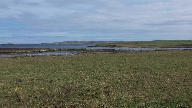
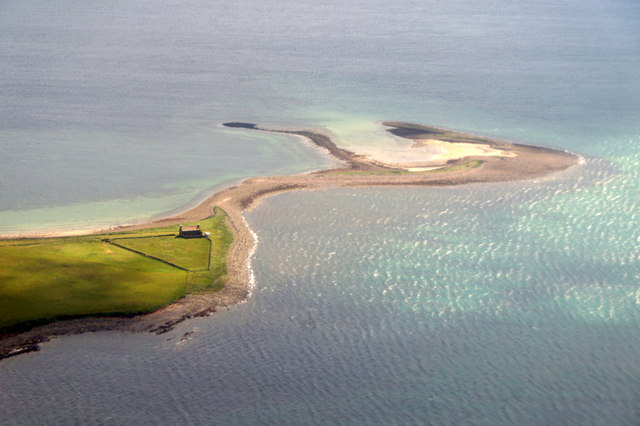
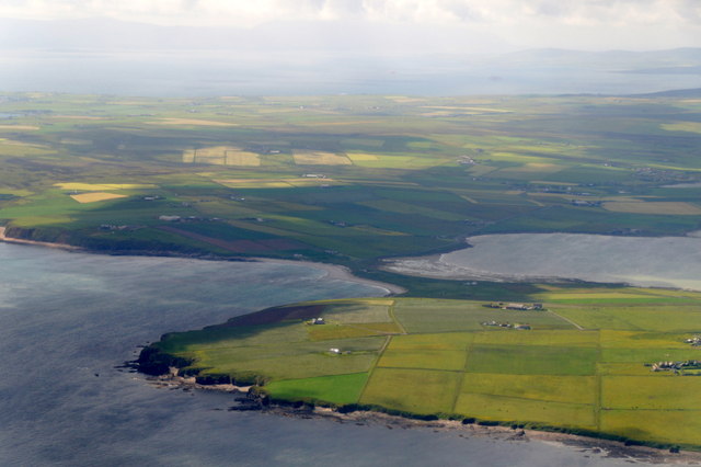
Point of Od is a coastal marsh located in Orkney, an archipelago in the northern part of Scotland. Situated on the eastern coast of Mainland, the largest island in the Orkney group, Point of Od is characterized by its unique coastal marsh and saltings.

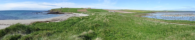
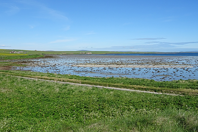
The marshland at Point of Od is a diverse ecosystem, encompassing a variety of habitats including mudflats, salt marshes, and sand dunes. These habitats are influenced by the tidal patterns of the North Sea, resulting in a dynamic environment that supports a rich array of flora and fauna.

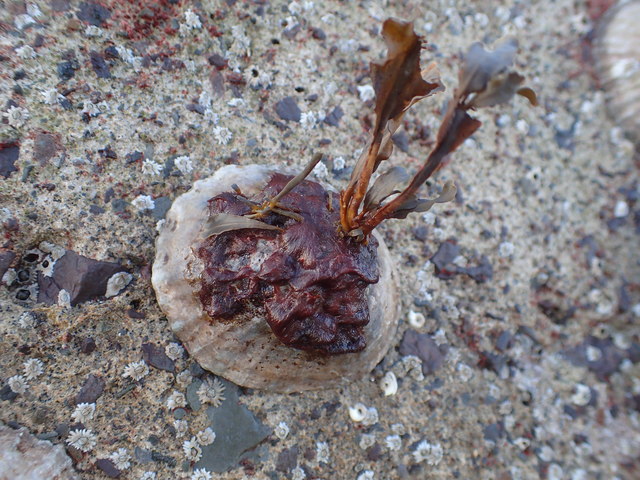
The mudflats of Point of Od provide an important feeding ground for various species of shorebirds, such as oystercatchers, curlews, and redshanks, which can be seen probing the mud for invertebrates. The salt marshes are dominated by grasses and salt-tolerant plants like sea aster and sea lavender, providing shelter and food for numerous bird species and invertebrates.

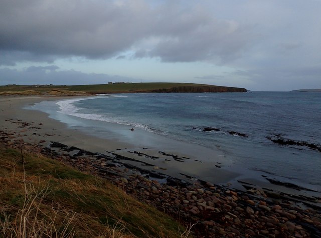
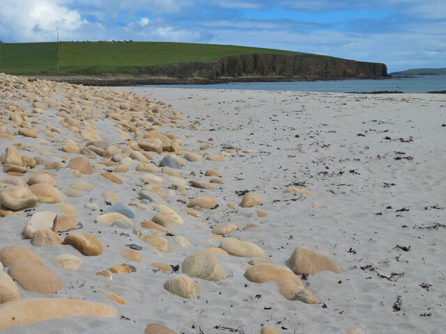
The sand dunes at Point of Od add another dimension to the landscape, with their shifting sands and hardy vegetation. These dunes act as a barrier against coastal erosion, protecting the marshland behind them.

Point of Od is not only a haven for wildlife, but it also offers breathtaking views of the surrounding coastline and the North Sea. Visitors can enjoy walks along the coast, observing the diverse birdlife and taking in the beautiful scenery.

Due to its ecological significance, Point of Od has been designated as a Site of Special Scientific Interest (SSSI), ensuring its protection and conservation for future generations to appreciate and enjoy.

If you have any feedback on the listing, please let us know in the comments section below.

Point of Od Images

Images are sourced within 2km of 58.928226/-2.8003925 or Grid Reference HY5404. Thanks to Geograph Open Source API. All images are credited.
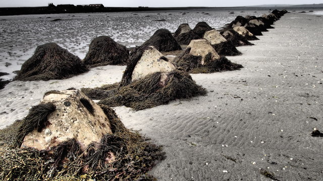
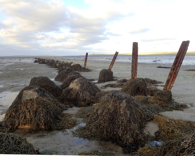
Anti-tank structures These are not marked on any map I can find, nor is their purpose obvious. But research reveals that they are WW2 anti tank (anti-invasion) structures. Mostly of truncated pyramids though some are filled oil-drums. Others, I'm told, can be found nearby on dry land.
Anti-tank structures
These are not marked on any map I can find, nor is their purpose obvious. But research reveals that they are WW2 anti tank (anti-invasion) structures. Mostly of truncated pyramids though some are filled oil-drums. Others, I'm told, can be found nearby on dry land.
Toab A field beside Bay of Suckquoy.
Toab
A field beside Bay of Suckquoy.
Lastlight in the bay Dingieshowe Bay is very popular in the summer. Lovely sand, gentle beach, sand-dunes, toilets and a good view of islands.
This is the beach where I collect washed-up small red seaweeds to identify at home.
Lastlight in the bay
Dingieshowe Bay is very popular in the summer. Lovely sand, gentle beach, sand-dunes, toilets and a good view of islands. This is the beach where I collect washed-up small red seaweeds to identify at home.
Dingieshowe Bay west end A very popular bay all year but specially with summer visitors, the skies are big and the sea bracing!
Dingieshowe Bay west end
A very popular bay all year but specially with summer visitors, the skies are big and the sea bracing!
Mirkady Point, Deerness, from the air
The isthmus connecting Deerness to Mainland, from the air
Tombolo The isthmus that links Deerness to the rest of Orkney is a tombolo, formed by two beaches back-to-back.
Tombolo
The isthmus that links Deerness to the rest of Orkney is a tombolo, formed by two beaches back-to-back.
Beach on Taracliff Bay This is the southerly, and more exposed, of the two sandy beaches making up the tombolo between Deerness and the rest of Mainland. The farms on the headland are Turnpike on the left and Biggings on the right.
Beach on Taracliff Bay
This is the southerly, and more exposed, of the two sandy beaches making up the tombolo between Deerness and the rest of Mainland. The farms on the headland are Turnpike on the left and Biggings on the right.
Sandi Sand This is the more northerly, and much more sheltered, of the two beaches that together make up the tombolo that links Deerness to the rest of Mainland.
Sandi Sand
This is the more northerly, and much more sheltered, of the two beaches that together make up the tombolo that links Deerness to the rest of Mainland.
Old Milestone by the A960, St Peter's Pool, Kirkwall By the A960, in parish of Kirkwall St Ola (Mainland District), St Peter's Pool, West of bungalow.

Inscription reads:- : K / 8 : : D / 3¾ : (To Kirkwall and Deerness)

Surveyed

Milestone Society National ID: OR_KWDN08
Old Milestone by the A960, St Peter's Pool, Kirkwall
By the A960, in parish of Kirkwall St Ola (Mainland District), St Peter's Pool, West of bungalow. Inscription reads:- : K / 8 : : D / 3¾ : (To Kirkwall and Deerness) Surveyed Milestone Society National ID: OR_KWDN08
Old Milestone by the A960, St Ola, Kirkwall parish Stone post by the A960, in parish of Kirkwall, St Ola (Mainland District), East of bungalow, on verge, on rise, South side of road.

Inscription reads:-
: K / 7 : : D / 4¾ :
(To Kirkwall and Deerness)

Surveyed

Milestone Society National ID: OR_KWDN07
Old Milestone by the A960, St Ola, Kirkwall parish
Stone post by the A960, in parish of Kirkwall, St Ola (Mainland District), East of bungalow, on verge, on rise, South side of road. Inscription reads:- : K / 7 : : D / 4¾ : (To Kirkwall and Deerness) Surveyed Milestone Society National ID: OR_KWDN07
Old Milestone by the B9051, Halley Road, North Windbreck Stone post by the B9051, in parish of St Andrews and Deerness (Mainland District), North Windbreck, over ditch on banking, East side of road.

Inscription reads:-
: K / 10 : : D / 1¼ :
(To Kirkwall and Deerness)

Surveyed

Milestone Society National ID: OR_KWDN10
Old Milestone by the B9051, Halley Road, North Windbreck
Stone post by the B9051, in parish of St Andrews and Deerness (Mainland District), North Windbreck, over ditch on banking, East side of road. Inscription reads:- : K / 10 : : D / 1¼ : (To Kirkwall and Deerness) Surveyed Milestone Society National ID: OR_KWDN10
Old Milestone by the A960, west of Grind, St Andrews and Deerness Stone post by the A960, in parish of St Andrews and Deerness (Mainland District), West of Grind, on banking, South side of road.

Inscription reads:-
: K / 9 : : D / 2¾ :
(To Kirkwall and Deerness)

Surveyed

Milestone Society National ID: OR_KWDN09
Old Milestone by the A960, west of Grind, St Andrews and Deerness
Stone post by the A960, in parish of St Andrews and Deerness (Mainland District), West of Grind, on banking, South side of road. Inscription reads:- : K / 9 : : D / 2¾ : (To Kirkwall and Deerness) Surveyed Milestone Society National ID: OR_KWDN09
Wartime Structures These structures are worth recording - I can find no Web-references. They are significant historical and ecological features. The whole line, of mostly concrete truncated pyramids, reaches nearly 200 metres from dry land to quite low water. Some are exposed for most of the day, others for only an hour or two.
They all have a good coating of Wracks (seaweeds) which hide a varied collection of other Marine organisms, some quite rare.
Linked to <a title="https://www.geograph.org.uk/photo/4717066" href="https://www.geograph.org.uk/photo/4717066">Link</a>
and my series of iSpot Observations here <span class="nowrap"><a title="https://www.ispotnature.org/communities/uk-and-ireland/view/observation/778731/" rel="nofollow ugc noopener" href="https://www.ispotnature.org/communities/uk-and-ireland/view/observation/778731/">Link</a><img style="margin-left:2px;" alt="External link" title="External link - shift click to open in new window" src="https://s1.geograph.org.uk/img/external.png" width="10" height="10"/></span>
Wartime Structures
These structures are worth recording - I can find no Web-references. They are significant historical and ecological features. The whole line, of mostly concrete truncated pyramids, reaches nearly 200 metres from dry land to quite low water. Some are exposed for most of the day, others for only an hour or two. They all have a good coating of Wracks (seaweeds) which hide a varied collection of other Marine organisms, some quite rare. Linked to Link and my series of iSpot Observations here LinkExternal link
Rare seaweed The Wartime anti-tank structures at this location <a title="https://www.geograph.org.uk/photo/6190823" href="https://www.geograph.org.uk/photo/6190823">Link</a> are ecologically significant. Some of the lowest ones host quite rare marine organisms. There are plenty of common limpets of course.
On a few, and on some concrete surfaces, there is the quite rare seaweed Colaconema caespitosum - <span class="nowrap"><a title="http://www.seaweed.ie/descriptions/Colaconema_caespitosum.php" rel="nofollow ugc noopener" href="http://www.seaweed.ie/descriptions/Colaconema_caespitosum.php">Link</a><img style="margin-left:2px;" alt="External link" title="External link - shift click to open in new window" src="https://s1.geograph.org.uk/img/external.png" width="10" height="10"/></span>
World distribution - <span class="nowrap"><a title="https://www.gbif.org/species/5278379" rel="nofollow ugc noopener" href="https://www.gbif.org/species/5278379">Link</a><img style="margin-left:2px;" alt="External link" title="External link - shift click to open in new window" src="https://s1.geograph.org.uk/img/external.png" width="10" height="10"/></span>
Personally, I think the structures should be protected for their historical and environmental value.
Rare seaweed
The Wartime anti-tank structures at this location Link are ecologically significant. Some of the lowest ones host quite rare marine organisms. There are plenty of common limpets of course. On a few, and on some concrete surfaces, there is the quite rare seaweed Colaconema caespitosum - LinkExternal link World distribution - LinkExternal link Personally, I think the structures should be protected for their historical and environmental value.
Taracliff Bay Sandy bay on the south side of the isthmus that joins the peninsula of Deerness to the rest of Mainland Orkney.
Taracliff Bay
Sandy bay on the south side of the isthmus that joins the peninsula of Deerness to the rest of Mainland Orkney.
Sandi Sand This looks rather less inviting [except to wading birds] than the fine sandy beach on the other side of the isthmus.
Sandi Sand
This looks rather less inviting [except to wading birds] than the fine sandy beach on the other side of the isthmus.
Eggs for Sale By the roadside near Garth.
Eggs for Sale
By the roadside near Garth.
Show me another place!

Point of Od is located at Grid Ref: HY5404 (Lat: 58.928226, Lng: -2.8003925)

Unitary Authority: Orkney Islands

Police Authority: Highlands and Islands

What 3 Words

///ballooned.seashell.emerge. Near Deerness, Orkney Islands

Related Wikis

St Peter's Pool, Orkney

St Peter's Pool is a bay in the East Mainland of Orkney, Scotland. This bay was the site of significant coastal defences during World War II, when a German...

Mine Howe

Mine Howe is an Iron Age subterranean man-made chamber dug 6 meters (20 feet) deep inside a large mound. It is located in the Tankerness area of Orkney...

Deerness

Deerness (, locally , Old Norse: Dyrnes) is a quoad sacra parish (i.e. one created and functioning for ecclesiastical purposes only) and peninsula in Mainland...

Toab, Orkney

Toab is a parish on the Orkney Mainland, situated in the East Mainland. Toab is located off the A960 road at the head of Deer Sound on the Mainland, Orkney...

Nearby Amenities

Located within 500m of 58.928226,-2.8003925
Ste Peter's Kirk (remains of)
Historic: archaeological_site
Lat/Long: 58.9254657/-2.8064093
The data included in this document is from www.openstreetmap.org. The data is made available under ODbL.

Have you been to Point of Od?

Leave your review of Point of Od below (or comments, questions and feedback).