Abermenai Point

Coastal Marsh, Saltings in Anglesey

Wales

Abermenai Point

Warren Farm
Warren Farm Credit: Ceri Thomas

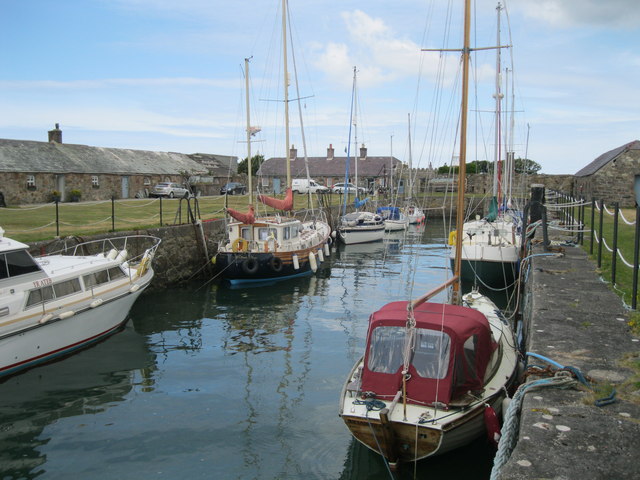
Abermenai Point is a coastal area located on the southwestern tip of Anglesey, an island off the northwest coast of Wales. This area is known for its unique blend of marshes and salt marshes, creating a diverse and important ecosystem for wildlife and plant species.

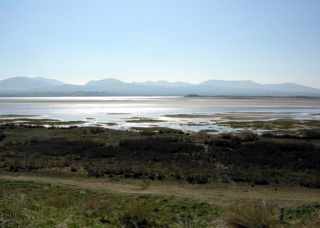
The marshes at Abermenai Point are characterized by their wet, muddy terrain, which provides a habitat for a variety of bird species, including waders, ducks, and geese. The salt marshes, on the other hand, are home to a range of salt-tolerant plants such as sea lavender and samphire.

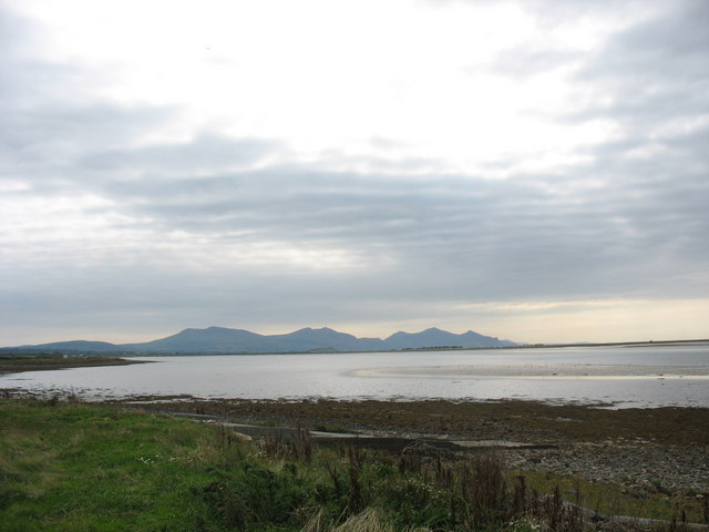
Visitors to Abermenai Point can enjoy scenic views of the Menai Strait and the Snowdonia mountain range, making it a popular spot for birdwatching and nature walks. The area is also significant for its archaeological remains, including the ruins of a Roman watchtower and a medieval church.

Overall, Abermenai Point is a picturesque and ecologically important coastal marsh and salt marsh area that offers a unique glimpse into the diverse ecosystems of Anglesey.

If you have any feedback on the listing, please let us know in the comments section below.

Abermenai Point Images

Images are sourced within 2km of 53.1291/-4.3282113 or Grid Reference SH4461. Thanks to Geograph Open Source API. All images are credited.

Warren Farm
Warren Farm
Boulders along the shoreline of Foryd Bay A high spring tide in the bay which is a Site of Special Scientific Interest and a Local Nature Reserve. The mountains are about 9 miles away on the Llŷn Peninsula.
Boulders along the shoreline of Foryd Bay
A high spring tide in the bay which is a Site of Special Scientific Interest and a Local Nature Reserve. The mountains are about 9 miles away on the Llŷn Peninsula.
End of the public right of way
Turn back here After a stroll along the embankment from Rhyd-felen it was frustrating to find the way blocked at this point, which marks the end of the public right of way. Ahead were sufficient strands of barbed wire etc to make a route across the dunes to the west sie of the headland a less than attractive proposition. Braver souls might have carried on.
Turn back here
After a stroll along the embankment from Rhyd-felen it was frustrating to find the way blocked at this point, which marks the end of the public right of way. Ahead were sufficient strands of barbed wire etc to make a route across the dunes to the west sie of the headland a less than attractive proposition. Braver souls might have carried on.
Warren Farm Farm on Morfa Dinlle situated between the embankment and the dunes in an area where there is some pasture.
Warren Farm
Farm on Morfa Dinlle situated between the embankment and the dunes in an area where there is some pasture.
Warren Farm
Warren Farm
Sea wall, western shore of Y Foryd Also a public footpath.
Sea wall, western shore of Y Foryd
Also a public footpath.
Tidal creek, Y Foryd Two and a half hours after high tide.
Tidal creek, Y Foryd
Two and a half hours after high tide.
Fields near Warren Farm On the west side of Foryd Bay, north of Caernarfon Airport.
Fields near Warren Farm
On the west side of Foryd Bay, north of Caernarfon Airport.
Plants by a muddy tidal creek, Y Foryd Nearly three hours after high tide.
Plants by a muddy tidal creek, Y Foryd
Nearly three hours after high tide.
A wet crossing Only slightly flooded sands of Traeth Abermenai looking NE across the strait. No danger.
A wet crossing
Only slightly flooded sands of Traeth Abermenai looking NE across the strait. No danger.
Inside the 'crook' of Abermenai Point A quite striking curve of differing surfaces: shingle, sand, dune grass and pretty pink flowers I'm not able to identify (anyone help?) and the misty mountains of the mainland beyond the low dunes.
Inside the 'crook' of Abermenai Point
A quite striking curve of differing surfaces: shingle, sand, dune grass and pretty pink flowers I'm not able to identify (anyone help?) and the misty mountains of the mainland beyond the low dunes.
Cormorant's Rest Looking south across the mouth of the Menai Strait with Fort Belan just out of shot on the left. Cormorants resting on a sand bar just offshore.
Cormorant's Rest
Looking south across the mouth of the Menai Strait with Fort Belan just out of shot on the left. Cormorants resting on a sand bar just offshore.
Desirable Residence? Probably a beach fisher's bothy decorated with a sense of humour. There was no address to which to apply, though.  :(
Desirable Residence?
Probably a beach fisher's bothy decorated with a sense of humour. There was no address to which to apply, though. :(
Fort Belan Dock Belan Dock was largely constructed by the second Baron Newborough and completed in 1826. His passion for maritime life did much to shape Belan's history. The cottages that surround the tidal dock on three sides are used as holiday accommodation.
Fort Belan Dock
Belan Dock was largely constructed by the second Baron Newborough and completed in 1826. His passion for maritime life did much to shape Belan's history. The cottages that surround the tidal dock on three sides are used as holiday accommodation.
Crane at Fort Belan Dock This disused crane is situated at the dockhead, which faces ESE.
Crane at Fort Belan Dock
This disused crane is situated at the dockhead, which faces ESE.
Slipway at Fort Belan The slipway is situated next to Fort Belan Dock and faces up the Menai Strait towards Caernarfon.
Slipway at Fort Belan
The slipway is situated next to Fort Belan Dock and faces up the Menai Strait towards Caernarfon.
Show me another place!

Abermenai Point is located at Grid Ref: SH4461 (Lat: 53.1291, Lng: -4.3282113)

Unitary Authority: Isle of Anglesey

Police Authority: North Wales

What 3 Words

///frame.robot.digested. Near Caernarfon, Gwynedd

Nearby Locations

Abermenai Point

Related Wikis

Abermenai Point

Abermenai Point (Welsh: Pwynt Abermenai) is a headland in the southeast of the island of Anglesey in Wales. It is the southernmost point of the island...
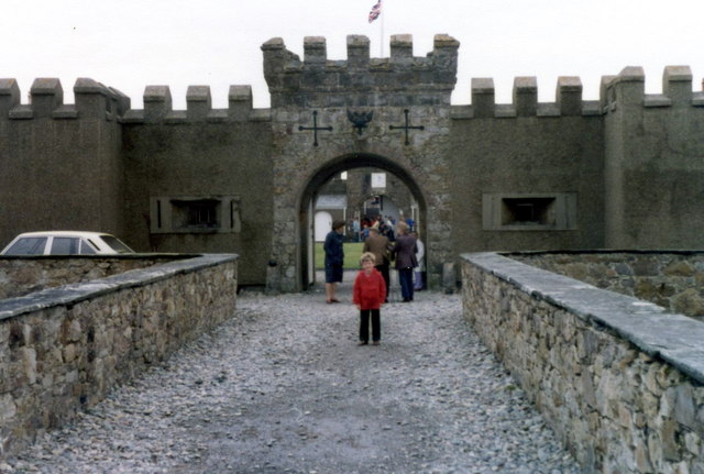
Fort Belan

Fort Belan (alternative: Belan Fort; pronounced: Bell-ann) is a coastal fortress in North Wales. It is located opposite Abermenai Point, at the south...

St Baglan's Church, Llanfaglan

St Baglan's Church, Llanfaglan, is a redundant church in the parish of Llanfaglan, Gwynedd, Wales. It is designated by Cadw as a Grade I listed building...

Foryd Bay

Foryd Bay, or Y Foryd (Welsh for 'the estuary' / 'the inlet'), is a tidal bay in Gwynedd, Wales. It is located at the south-western end of the Menai Strait...

Nearby Amenities

Located within 500m of 53.1291,-4.3282113
Source: PGS
Lat/Long: 53.1276427/-4.3318821
Source: PGS
Lat/Long: 53.1274488/-4.3316129
Source: PGS
Lat/Long: 53.127329/-4.3314089
Source: PGS
Lat/Long: 53.1269939/-4.3310046
Source: PGS
Lat/Long: 53.1263876/-4.3301099
Source: PGS
Lat/Long: 53.1263456/-4.3295312
Seamark Light 1 Character: Fl
Seamark Light 1 Colour: white
Seamark Light 1 Height: 6
Seamark Light 1 Period: 3.5
Seamark Light 1 Range: 3
Seamark Light 1 Sector End: 65
Seamark Light 1 Sector Start: 245
Seamark Light 1 Sequence: 0.5+(3)
Seamark Light 2 Character: Fl
Seamark Light 2 Colour: red
Seamark Light 2 Height: 6
Seamark Light 2 Period: 3.5
Seamark Light 2 Range: 3
Seamark Light 2 Sector End: 245
Seamark Light 2 Sector Start: 65
Seamark Light 2 Sequence: 0.5+(3)
Seamark Light Reference: A 5212
Seamark Name: Abermenai Point
Seamark Type: light_minor
Source: US NGA Pub. 114. 2011-05-26.
Lat/Long: 53.1269667/-4.32855
Source: PGS
Lat/Long: 53.128174/-4.33294
Source: PGS
Lat/Long: 53.128421/-4.333799
Source: PGS
Lat/Long: 53.128668/-4.334659
Source: PGS
Lat/Long: 53.1288343/-4.3355494
Abermenai Point
Name Cy: Trwyn Abermenai
Place: locality
Lat/Long: 53.1276132/-4.3283184
The data included in this document is from www.openstreetmap.org. The data is made available under ODbL.

Have you been to Abermenai Point?

Leave your review of Abermenai Point below (or comments, questions and feedback).