Bàgh Leac Finn

Coastal Marsh, Saltings in Sutherland

Scotland

Bàgh Leac Finn

An t- Sròn and Loch Eriboll With the settlement of Kempie on the left. The A838 making its way over the top of An t- Sròn.
An t- Sròn and Loch Eriboll Credit: Russel Wills

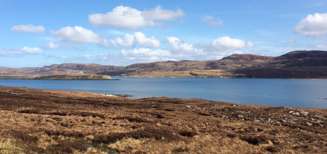
Bàgh Leac Finn, located in Sutherland, Scotland, is a coastal marsh and saltings area that spans approximately 200 acres. It is known for its unique ecological features and diverse wildlife. The site is situated along the north coast of Scotland, overlooking the North Sea.

The marshland is characterized by its wet and muddy terrain, which is influenced by the nearby ocean tides. The area is home to a variety of plant species, including salt-tolerant vegetation such as sea lavender, sea aster, and sea purslane. These plants provide essential habitat and food sources for a range of bird species.

Bàgh Leac Finn is an important site for migratory birds, acting as a stopover point during their long journeys. Species such as curlews, redshanks, dunlins, and ringed plovers can be spotted here, making it a popular location for birdwatchers and nature enthusiasts.

The coastal marsh also supports a diverse range of marine life. Many species of fish, crustaceans, and mollusks can be found in the shallow waters and mudflats of the saltings. These invertebrates attract larger predators such as otters and herons.

The area is managed by a local conservation organization, which aims to protect and preserve the unique biodiversity of Bàgh Leac Finn. The site offers educational programs and guided tours to raise awareness about the importance of wetland ecosystems and the need for their conservation.

Overall, Bàgh Leac Finn is a fascinating coastal marsh and saltings area that provides a vital habitat for various plant and animal species. Its ecological significance and natural beauty make it a valuable asset to the region's biodiversity.

If you have any feedback on the listing, please let us know in the comments section below.

Bàgh Leac Finn Images

Images are sourced within 2km of 58.47406/-4.6960397 or Grid Reference NC4257. Thanks to Geograph Open Source API. All images are credited.

An t- Sròn and Loch Eriboll With the settlement of Kempie on the left. The A838 making its way over the top of An t- Sròn.
An t- Sròn and Loch Eriboll
With the settlement of Kempie on the left. The A838 making its way over the top of An t- Sròn.
Eriboll kirk, a Church of Scotland outpost
An t-Sron, Loch Eriboll An t-Sron (The Nose), a rocky promontory on the coast of Loch Eriboll.
An t-Sron, Loch Eriboll
An t-Sron (The Nose), a rocky promontory on the coast of Loch Eriboll.
Loch Eriboll Limestone coast on the east side of Loch Eriboll.
Loch Eriboll
Limestone coast on the east side of Loch Eriboll.
Inbhirean, a harbour at Loch Eriboll Stones have been cleared from the shore to create a landing place for boats.
Inbhirean, a harbour at Loch Eriboll
Stones have been cleared from the shore to create a landing place for boats.
Meall Bad a ' Mhuidhe The summit of the hill, looking towards the mouth of Loch Eriboll.
Meall Bad a ' Mhuidhe
The summit of the hill, looking towards the mouth of Loch Eriboll.
Meall Bad a' Mhartuin Meall Bad a' Mhartuin viewed from the col to the south.
Meall Bad a' Mhartuin
Meall Bad a' Mhartuin viewed from the col to the south.
The prime man-made feature in this area, Eriboll church
Summer greens the fields of Eriboll
A838 looking across Loch Eriboll to Cranstackie
An t- Sròn and Loch Eriboll This small bay has the odd name 'Roadstead'.
An t- Sròn and Loch Eriboll
This small bay has the odd name 'Roadstead'.
Ruin above Loch Eribol RFA Lyme Bay on exercise on the Loch
Ruin above Loch Eribol
RFA Lyme Bay on exercise on the Loch
Eriboll Kirk A small Church of Scotland kirk which, it seems, is no longer used for regular services but is available for special events such as weddings.
Eriboll Kirk
A small Church of Scotland kirk which, it seems, is no longer used for regular services but is available for special events such as weddings.
Roadside gravel pit near Kempie
Loch Eriboll View towards the loch, with the southern tip of Eilean Choraidh visible on the left.
Loch Eriboll
View towards the loch, with the southern tip of Eilean Choraidh visible on the left.
Kempie: Scene from the A838 just prior to heavy rainfall
Autumn colours at Allt Eriboll
Eriboll Church Now appears to be disused - note that the right hand window has gone compared to other images of this feature
Eriboll Church
Now appears to be disused - note that the right hand window has gone compared to other images of this feature
Show me another place!

Bàgh Leac Finn is located at Grid Ref: NC4257 (Lat: 58.47406, Lng: -4.6960397)

Unitary Authority: Highland

Police Authority: Highlands and Islands

What 3 Words

///unto.still.acoustics. Near Oldshoremore, Highland

Nearby Locations

Bàgh Leac Finn

Related Wikis

Eriboll

Eriboll (Scottish Gaelic: Earabol) is a village in Sutherland, Scotland. The village is situated on the south eastern shore of Loch Eriboll, in the northern...
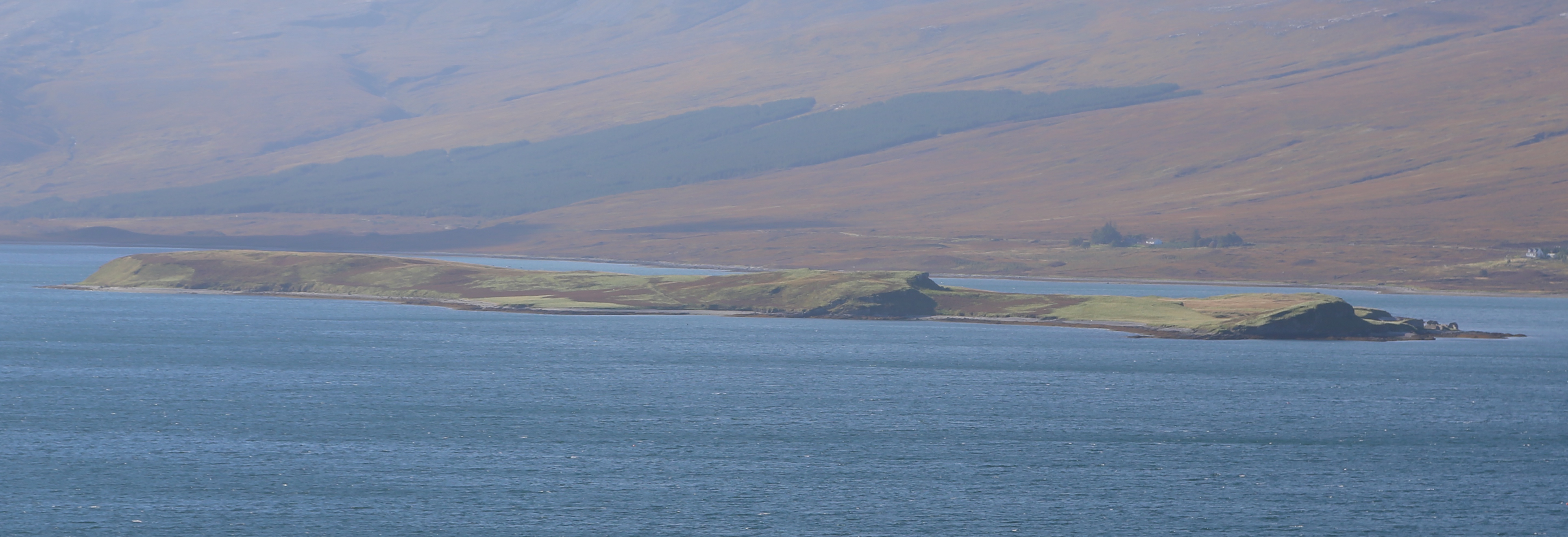
Eilean Choraidh

Eilean Choraidh, also known as Horse Island is an island in Loch Eriboll in Sutherland on the north coast of Scotland. It is about 26 hectares (64 acres...
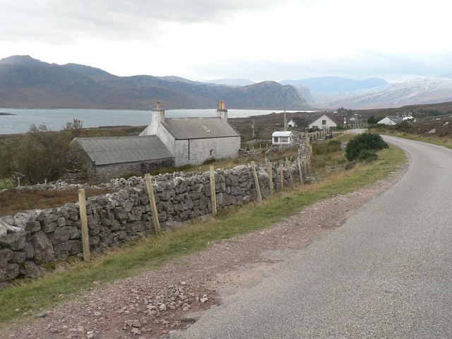
Laid, Sutherland

Laid is a remote, linear crofting township scattered along the A838 road on the western shore of the sea loch, Loch Eriboll in Sutherland in the northern...

Portnancon

Portnacon is a small remote crofting township, and former fishing station, on the west shore of Loch Eriboll in Sutherland, Scottish Highlands in the...

Related Videos

NC500 , lone campers , me and the dog called Chester

NC500 , lone camping Just me and the dog called Chester ...(misses was asleep inside ) drizzly evening found this little camp site ...

Nearby Amenities

Located within 500m of 58.47406,-4.6960397
Source: PGS
Lat/Long: 58.4773668/-4.6906979
Source: PGS
Lat/Long: 58.4775271/-4.692813
Source: PGS
Lat/Long: 58.4779383/-4.6936518
Source: PGS
Lat/Long: 58.477912/-4.6945703
Source: PGS
Lat/Long: 58.4776251/-4.6952087
Created By: almien_coastlines
Source: PGS
Lat/Long: 58.477388/-4.69576
Source: PGS
Lat/Long: 58.4765543/-4.6960488
Source: PGS
Lat/Long: 58.4764274/-4.6956076
Source: PGS
Lat/Long: 58.475949/-4.6957446
Source: PGS
Lat/Long: 58.4744254/-4.6957222
Source: PGS
Lat/Long: 58.4740384/-4.6956475
Source: PGS
Lat/Long: 58.4730829/-4.696251
Source: PGS
Lat/Long: 58.4722879/-4.69736
Source: PGS
Lat/Long: 58.4715068/-4.6979801
Source: PGS
Lat/Long: 58.4707812/-4.6983573
Source: PGS
Lat/Long: 58.4700837/-4.6985638
Power: pole
Lat/Long: 58.4742569/-4.6875746
Power: pole
Lat/Long: 58.473639/-4.6879231
Power: pole
Lat/Long: 58.4729427/-4.6883027
Power: pole
Lat/Long: 58.4721711/-4.6887427
Power: pole
Lat/Long: 58.4714351/-4.6891515
Ford: yes
Lat/Long: 58.4731614/-4.6876624
The data included in this document is from www.openstreetmap.org. The data is made available under ODbL.

Have you been to Bàgh Leac Finn?

Leave your review of Bàgh Leac Finn below (or comments, questions and feedback).